
Utah’s Three Types of Volcanoes
Perhaps because it is covered in detail in Grade School and Middle School curriculum, one of the most asked geologic questions I hear from youth has to do with differentiating between the three types of volcanoes.
| Three Main Types of Volcanoes* | |||||
|---|---|---|---|---|---|
The three main types of volcanoes differ in shape, size, and make-up; the differences partly result from the different types of eruptions. | |||||
| Volcano Type | Volcano Shape | Volcano Size | Volcano Materials | Eruption Type | Utah Example |
Cinder Cone |  Steep conical hill with straight sides | Small less than 300m high | cinders | Explosive | Diamond Cinder Cone, Washington County |
Shield Volcano |  Very gentle slopes; convex upward (shaped like a warrior’s shield) | Large over 10s of kms across | fluid lava flows (basalt) | Quiet | Cedar Hill, Box Elder County |
Stratovolcano |  Gentle lower slopes, but steep upper slopes; concave upward | Large 1-10 km in diameter | numerous layers of lava and pyroclastics | Explosive | Mount Belknap, Tushar Mountains, Paiute County |
In the State of Utah there are many examples of the three main types of volcanoes. The following is a brief introduction to Utah’s volcanoes; only several of numerous volcanoes are mentioned.
Stratovolcanoes
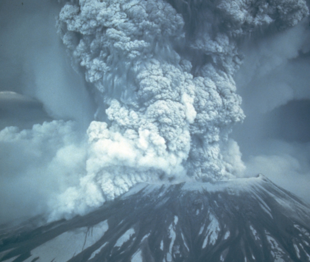
Stratovolcanoes erupted in western Utah between about 40 to 25 million years ago. At this time, Utah was closer to a continental-oceanic plate boundary where an oceanic plate (Farallon) was subducting underneath the North American continental plate. Stratovolcanoes are found at these types of plate boundaries.
Today’s active stratovolcanoes include those in the Cascade Range in Washington, Oregon, and California where an oceanic plate (Juan de Fuca) is subducting underneath the North American continental plate.
Two examples of Utah’s most recent stratovolcanoes are Mount Belknap in the Tushar Mountains and Monroe Peak on the Sevier Plateau. These stratovolcanoes exists on the tail end of a line of explosive volcanism that extended from near Richfield, southwestward to the Nevada border. Like ancient Yellowstone National Park, many of these volcanoes were among the largest volcanoes to ever erupt in North America.
Because these volcanoes are old and have been extensively eroded, it is difficult to distinguish the original volcano shapes.
Shield Volcanoes and Cinder Cones
Shield volcanoes and cinder cones started to erupt about 12 million years ago after plate motions and resulting crustal forces changed.
Compressional forces had eased, and the crust started to stretch between the Wasatch Range in Utah and the Sierra Nevada Range in California. This extension created splintered zones in the Earth’s crust where magma rose to the surface creating shield volcanoes and cinder cones. These types of volcanoes are far less explosive than stratovolcanoes and tend to create smaller deposits. Because the lava from shield volcanoes comes from a deeper source and contains more iron and less silica than stratovolcanoes, they tend to leave darker and thinner magma deposits.
The most recent volcanic activity in Utah occurred about 600 years ago in the Black Rock Desert (Millard County). The only place in the United States were these types of volcanoes are currently active is Hawaii.

Iceland and Hawaii are great modern examples of the shield volcanoes which have periodically erupted in Utah over the last 15 million years.
Science LanguageVolcano – a vent (opening) at the Earth’s crust through which magma (molten rock) and associated gases erupt. |
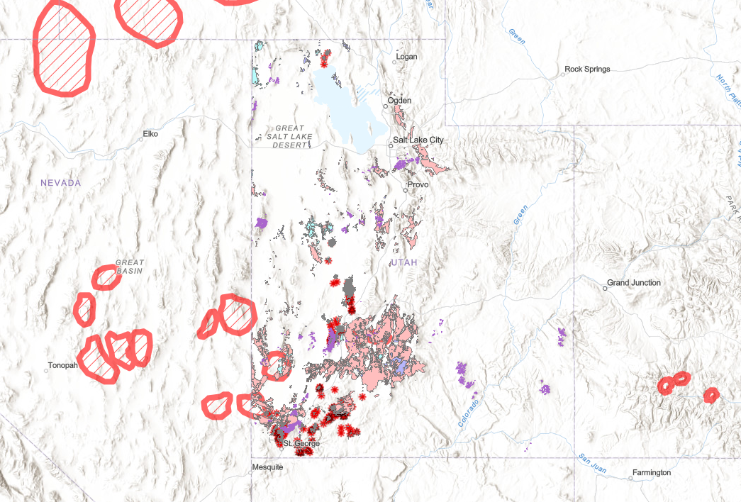
Map of Utah Volcanics. Hatched circles are ancient calderas. Pink shaded areas are exposed Rhyolite ash-fall and ash-flow tuffs (mostly Eocene/Oligocene). Purple are basalt deposits from Hawaii style lavas (mostly from the last 3 million years). Red starbursts are cinder cone volcanic vent/scoria cones which erupted the basaltic lava flows. Purple splotches on peaks of the Colorado Plateau/Colorado river area are oligocene/miocene laccolithic intrusions.
.
Utah Volcano Map
Use this map to zoom in and explore Utah’s various volcanic deposits. Each element can be clicked for more details. The top arrow opens a Legend which explains the meaning of the maps various features.
.
Age of Major Volcanoes in Utah and the Intermountain West.
–Valles Caldera/Jemez Volcanic Field: 1.2-1.3 mya / 14 mya
–Yellowstone Caldera: 2.1, 1.3 & .631 mya eruptions
–Long Valley Caldera (Bishop Tuff): .761 mya eruption
–San Francisco Peaks Volcano (Arizona): 2.8 -.4 mya eruptions
–Mount Rainer Volcano: 2 – .5mya (Most Cascade stratovolcanoes = 2mya-0.1mya)
–Mount Shasta Volcano: .590k (last eruption 10k yrs ago)
(Bill Williams Peak 2.8mya, Kendrick Peak 1.4mya, Sitgreaves Mountain 1.9mya, Humphries Peak ?)
-White Mountain Tuff/Rhyolite: .400 mya
–Mineral Mountains Beaver County: 18mya. (but starting in Oligocene)
–Silverton Caldera/San Juan Caldera: 27.6/28.4mya
-Boulder Mountain Tuff/Antimony Tuff: 25.13 to 26 Ma. (Cant be equal to Bishop Cong!)
-Utah Laccoliths: 31-20mya. Henrys/Abajo/La Sal (excess argon)
–Marysville Volcanics: 40-25mya (32-22mya)
–Absaroka Volcanics/Sunlight Peak: 53-43mya
–Bishop Conglomerate Ash Beds: 36-27mya (Oligocene=33.9-23 ma)
–Wah Wah Springs Caldera: 30.06mya
–Desert Mountain Volcanics: 40-30mya
-La Plata Intrusion: 75-60mya
–Carrizo Mountains Intrusion/Pastora Peak: 73.8-70.6mya (excess argon too? – both use same modern hornblende argon dating)
-Sierra Nevada Batholith: mostly 105-85mya (Cretaceous)
-Notch Peak Granite Intrusion: 170 mya (Jurassic).
–Twentynine Palms Monzonite, Earliest of Joshua Tree NP intrusions: 170mya (Jurassic). Most others are K.
-Snake River Calderas= McDermitt 16-15.1mya, Owyhee 13.8-12mya, Bruneau 12.5-11.3mya, Twin Falls 10-8.6mya, Picabo 10.2mya, Heise 6.6-4.4mya, Huckleberry/IslandPark/Yellowstone 2-.6mya
–Columbia River Basalts: 17-14mya




Is it possible that the Little Cottonwood Batholith was once a volcano?