Wingate/Moenave Sandstone (Geology of Utah’s Grand Staircase)
Explore unit thickness in All-in-One App

Exposure:
The Wingate is exposed throughout the state of Utah, especially visible in Capital Reef and Glen Canyon NRA. In the Southwest corner it transitions into and interfingers with the Moenave Fm which has a strong lacustrine component.
Age: Early Jurassic, The Wingate Sandstone is dated to the Earliest Jurassic, though precise dating of eolian deposits is typically difficult (see discussion in Navajo Sandstone).
Depositional Environment: Eolian (wind blown)
The Wingate Sandstone was deposited in an eolian environment made up of large sand dunes, similar to portions of the modern Sahara Desert. See Navajo Sandstone discussion for details that apply to the Wingate Sandstone as well.
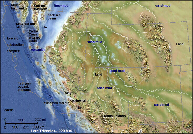
Paleogeography:
The Wingate Sandstone erg (a large sand sea) originally lay at very low latitude, centered approximately 10o north of the equator. Like the Navajo Sandstone, its sediment source was at least partly from the Appalachian Mountains (Dickenson and Gehrels 2003).
Directly adjacent to the south and west of the erg lay the erg margin facies of the Moenave Formation (Blakey et al. 1988, Blakey 1989, 2008, Clemmensen et al. 1989) .
Tectonics: The basinal area (created by tectonism) was subsiding significantly enough to provide enough accommodation space to capture and accumulate eolian sediment (Kocurek and Dott 1983).
Climate: Dry /Arid. Similar to the Navajo Sandstone, the climate in the Colorado Plateau region during deposition of the Wingate sandstone would have been very dry, classified as hyper-arid (Kocurek and Dott 1983, Loope et al. 2004).
Features: The Wingate tends to from very blocky, vertical cliffs, likely related to different grain sizes and cementation compared to the younger (overlying) Navajo Sandstone. Because of the cliff weathering and smooth vertical faces, it is often difficult to see and access sedimentary structures in the Wingate Sandstone. It contains large-scale cross stratification characteristic of dunes and shows internal grain fall, grain flow, and wind ripple strata. Further, the desert varnish, iron oxide staining and weathering pattern of the Wingate Sandstone commonly obscures the trough cross stratification.


Description:
Wingate Sandstone is particularly prominent in southeastern Utah, where it forms attractions in a number of national parks and monuments. These include Capitol Reef National Park, the San Rafael Swell, and Canyonlands National Park.
Wingate Sandstone frequently appears just below the Kayenta Formation and Navajo Sandstone, two other formations of the Glen Canyon group. Together, these three formations can result in immense vertical cliffs of 2,000 feet (610 meters) or more. Wingate layers are typically pale orange to red in color, the remnants of wind-born sand dunes deposited approximately 200 million years ago in the Late Triassic.
Long dated to the Early Jurassic only, fossils (including a phytosaur skull) and other evidence indicate that part of the Wingate Sandstone is as old as Late Triassic in age. The upper part of the formation, which laterally interfingers with the Moenave Formation to the west, is Early Jurassic in age
The Moenave was deposited on an erosion surface on the Chinle Formation following an early Jurassic uplift and unconformity that represents about ten million years of missing sedimentation. Periodic incursions of shallow seas from the north during the Jurassic flooded parts of Wyoming, Montana, and a northeast–southwest trending trough on the Utah/Idaho border. The Moenave was deposited in a variety of river, lake, and flood-plain environments, near the ancient Lake Dixie.
The oldest beds of this formation belong to the Dinosaur Canyon Member, a reddish, slope-forming rock layer with thin beds of siltstone that are interbedded with mudstone and fine sandstone.[4] The Dinosaur Canyon, with a local thickness of 140 to 375 feet (43 to 114 m), was probably laid down in slow-moving streams, ponds and large lakes. Evidence for this is in cross-bedding of the sediments and large numbers of fish fossils.
The upper member of the Moenave is the pale reddish-brown with a thickness of 75 to 150 feet (23 to 46 m) and cliff-forming Springdale Sandstone. It was deposited in swifter, larger, and more voluminous streams than the older Dinosaur Canyon Member. Fossils of large sturgeon-like freshwater fish have been found in the beds of the Springdale Sandstone. The next member in the Moenave Formation is the thin-bedded Whitmore Point, which is made of mudstone and shale. The lower red cliffs visible from the Zion Human History Museum (until 2000 the Zion Canyon Visitor Center) and the St. George Dinosaur Discovery Site, discovered on February 26, 2000, are accessible examples of this formation.
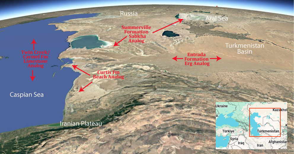
Modern Analog to Utah’s Middle Jurassic
.
Paleogeography or Depiction of Utah during Middle Jurassic
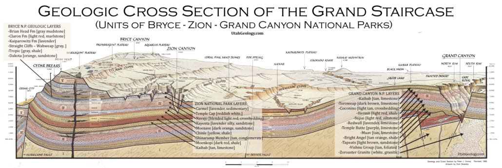
What is the Grand Staircase?
The Grand Staircase is a unique and extensive exposure of Earth’s history, showcasing over 200 million years of sedimentary rock layers. Geologists often liken these layers to a “book,” allowing for a detailed study of the Earth’s past, including changes in climate and environment.
The major sedimentary rock units exposed in the Grand Canyon range in age from 200 million to 600 million years and were deposited in warm shallow seas and near-shore environments. The nearly 40 identified rock layers of Grand Canyon form one of the most studied geologic columns in the world.

[flickr_tags user_id=”95435349@N04″ randomize=”true” margins=”4″ pagination=”numbers” tags=”navajo” max_num_photos=”9″]
[flickr_tags user_id=”95435349@N04″ tags=”chinle, navajo”]