Moenkopi Formation (Geology of Utah’s Grand Staircase)
Explore unit thickness in All-in-One App

Exposure:
The Moenkopi formation can be found throughout the Colorado Plateau. But its thickest extent stretches from southwest Utah to Northern Arizona.
Age: Lower Triassic to possibly lower Middle Triassic
Depositional Environment: Tidal sabkha (also with nearshore shales, shallow marine limestones, and some floodplain)
Paleogeography: The Moenkopi Formation was deposited along the western portion of the United States
Tectonics: There was very little tectonic activity was occurring during the time of deposition.
Climate: During the initial deposition of the Moenkopi Formation, the climate was rather hot and dry, then during the later members (the Sinbad Limestone through the Moody Canyon Members) the climate progressively got wetter, but it was likely still arid (Blakey, 1973).
Features: The Moenkopi Formation preserves extensive ancient tidal and nearshore deposits. Continental conditions were located to the east, and marine conditions to the west. Four different members of the Moenkopi were deposited in the Capitol Reef region. The lowest Black Dragon Member was deposited under marine conditions preserving a shallowing upwards sequence, capped by beach sands and fluvial (river) deposits. Cyclic alternation of supratidal (above the ocean level) to subtidal (below ocean the level) deposits resulted in interbedded (alternating) mud and sand beds throughout much of the Moenkopi (Blakey, 1973).
Following the Black Dragon Member, the Sinbad Limestone Member was deposited under shallow marine conditions before clastic sedimentation resumed in the overlying Torrey Member. The final member, The Moody Canyon Member, was deposited under widespread, uniform, low-energy marine conditions, producing a generally “structure-less” mudstone (Blakey, 1973).
The Moenkopi Formation typically contains abundant thinly bedded mudstones and sandstones (Figures 2 and 3) with a large variety of ripple marks (Figures 4 and 5), and some trace fossils (impressions from animals in the sediment) (Figures 6 and 7). Secondary gypsum veins cut through this formation (Figure 8 and 9).


Description:
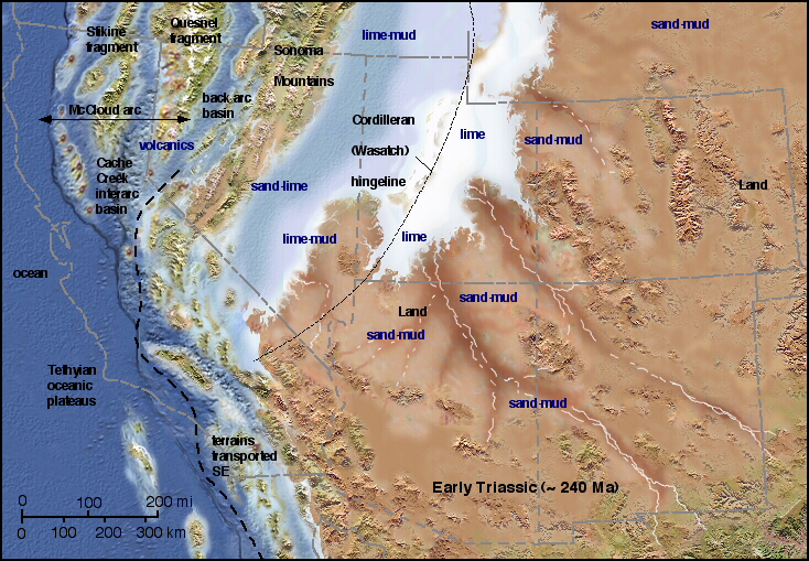
The Moenkopi consists of thinly bedded sandstone, mudstone, and shale, with some limestone in the Capitol Reef area. It has a characteristic deep red color and tends to form slopes and benches. The depositional environment varies from fluvial channel and floodplain deposits in the eastern exposures to tidal mudflats in the Cedar Mesa area to deltaic sandstones and shallow marine limestones at Capitol Reef. In eastern Nevada and northwestern Utah, it thickens dramatically, then transitions to the Woodside, Thaynes, and Mahogany formations.
The general deposition setting was sluggish rivers traversing a flat, featureless coastal plain to the sea. The low relief meant that the shoreline moved great distances with changes of sea level or even with the tides. Thickness varies from a feather edge against the Uncompahgre highlands to the east to over 600 metres (2,000 ft) in southwestern Utah. The thickness varies greatly in the Paradox Basin, where the Moenkopi is thin to nonexistent on the crests of salt anticlines and over 400 meters (1,300 feet) thick in the corresponding synclines.
The Moenkopi rests unconformably on Paleozoic beds and the Chinle Formation in turn rests unconformably on the Moenkopi. Both unconformities are locally angular unconformities. The lower unconformity corresponds to the regional Tr-1 unconformity and the upper to the regional Tr-3 unconformity. The Tr-1 unconformity represents a hiatus of at least 20 million years while Tr-2 represents a hiatus of about 10 million years.
Members differ considerably from east to west, in part because sandstone beds corresponding to marine transgressions are used to define members to the west but cannot be traced to the east.
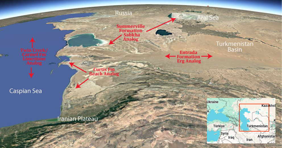
Modern Analog to Utah’s Middle Jurassic
.
Paleogeography or Depiction of Utah during Middle Jurassic
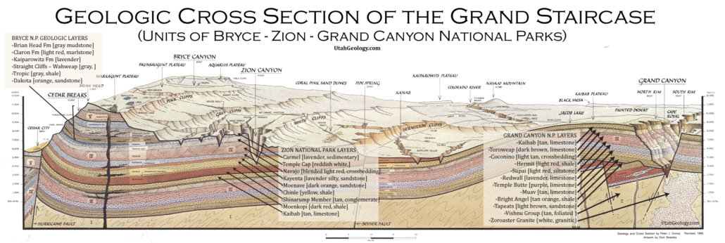
What is the Grand Staircase?
The Grand Staircase is a unique and extensive exposure of Earth’s history, showcasing over 200 million years of sedimentary rock layers. Geologists often liken these layers to a “book,” allowing for a detailed study of the Earth’s past, including changes in climate and environment.
The major sedimentary rock units exposed in the Grand Canyon range in age from 200 million to 600 million years and were deposited in warm shallow seas and near-shore environments. The nearly 40 identified rock layers of Grand Canyon form one of the most studied geologic columns in the world.

[flickr_tags user_id=”95435349@N04″ randomize=”true” margins=”4″ pagination=”numbers” tags=”navajo” max_num_photos=”9″]
[flickr_tags user_id=”95435349@N04″ tags=”chinle, navajo”]