Geologic History of Utah & the Colorado Plateau
(Colorado Plateau Paleogeography)
By Lance Weaver. Geologist: Utah Geological Survey
(See the latest version of this article at this link.)
As a geologist for the Utah Geological Survey, author of the website utahgeology.com, and owner of my own geologic tour business, I’ve spent over 20 years studying the geology of Utah. Growing up in St George, Utah placed me in a special situation of being able to spend my childhood roaming around the scenic denuded rocks of Southwest Utah in one of the very few places on earth where the entire rock record from the Precambrian to the Late Cenozoic is exposed within a 20-40 mile radius. In grade school I built forts in the rocks of the Triassic Chinle Formation behind my house and rode my bike over the pastry hills of the Moenkopi. As a High schooler I started rappelling the cliffs of the Kayenta Formation and Canyoneering the world famous slot canyons of the Jurassic Navajo Sandstone of Zion National Park. In College I hiked throughout the Grand Staircase of the Cretaceous, the Paleozoic rocks of the Grand Canyon and Virgin River Gorge.
I’ve put an enormous amount of thought and study into the geologic history of Utah and the Colorado Plateau over the last decade. In this article I showcase my unique paleogeography maps of the Colorado Plateau and offer geologic history reconstructions based on data from all available geologic maps, strat columns literally thousands of data points. Additionally I attempt to combat what I believe are many false ideas embedded in conventional models based on faulty logic and old data. These maps are vector based and created in Adobe Illustrator, loosely based Ron Blakey’s previous work but correcting many of his poor interpretations. If you have questions or comments, feel free to contact me by looking me up at the Utah Geological Survey.
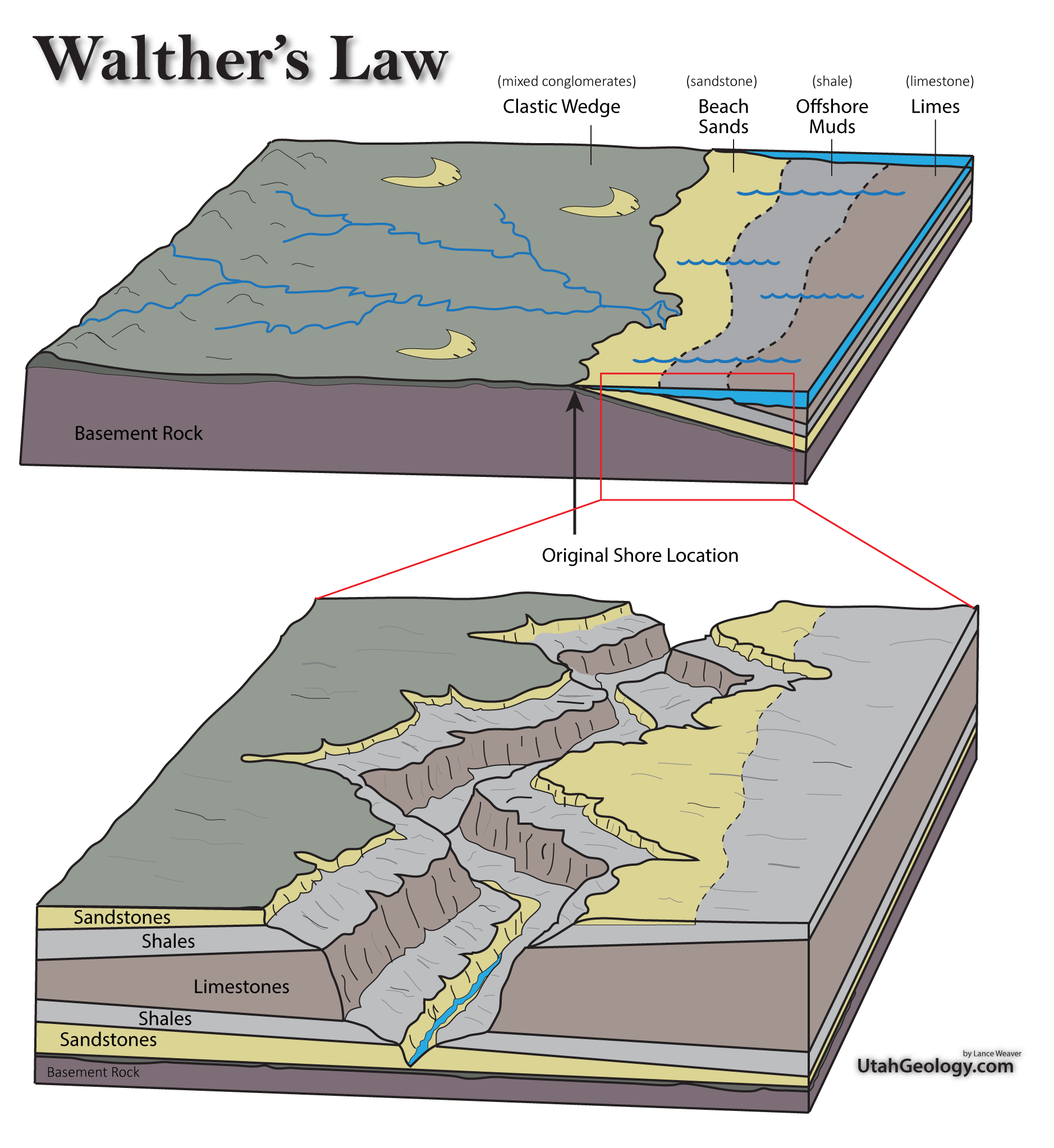
Geologic Overview & Understanding Geologic Facies
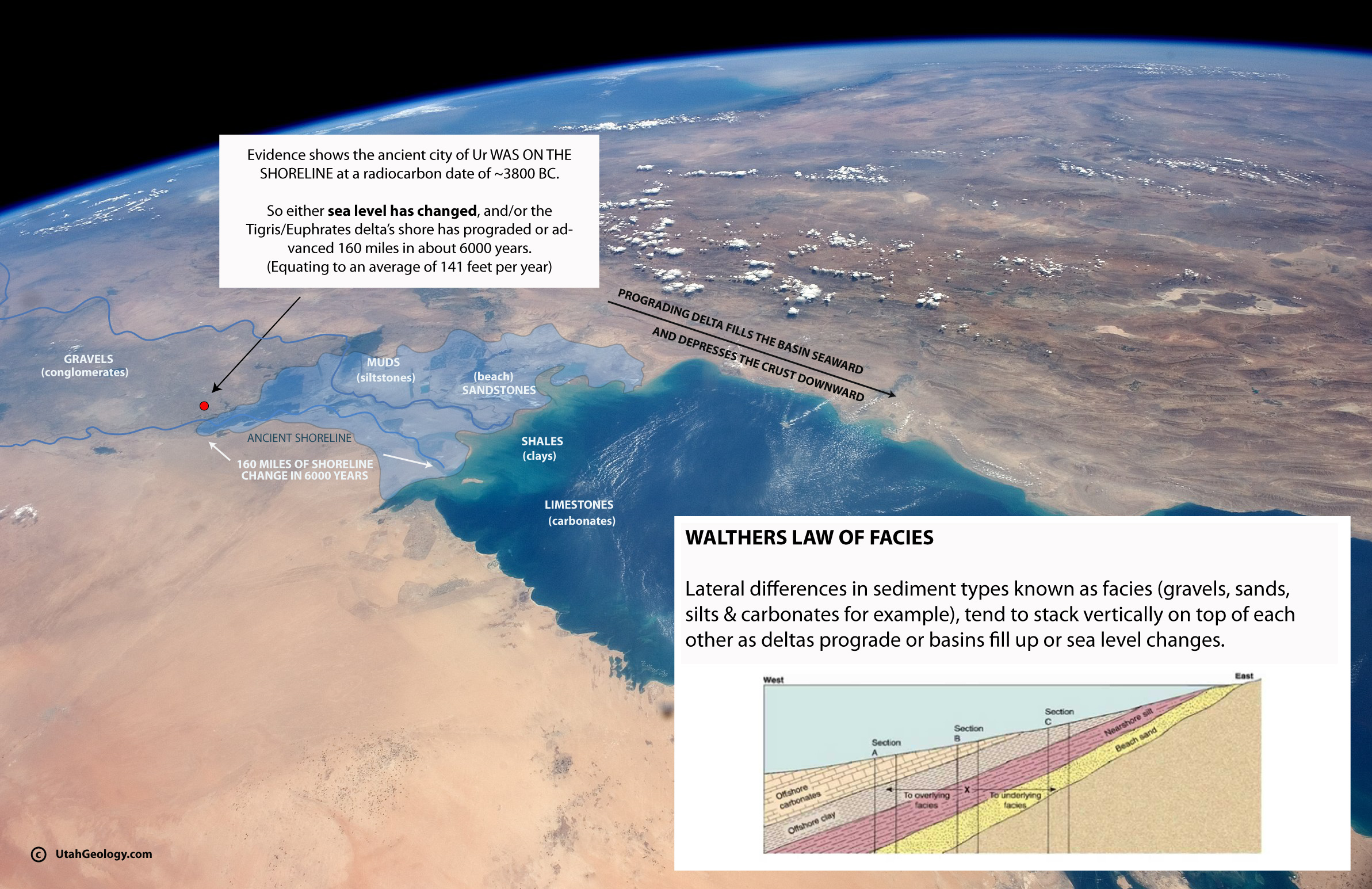
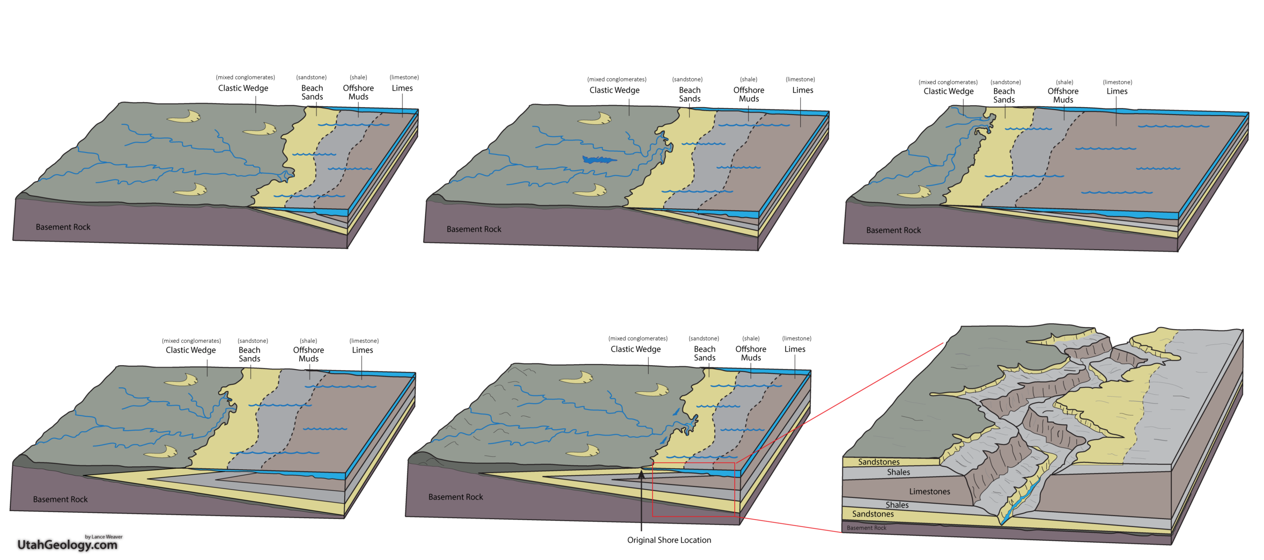
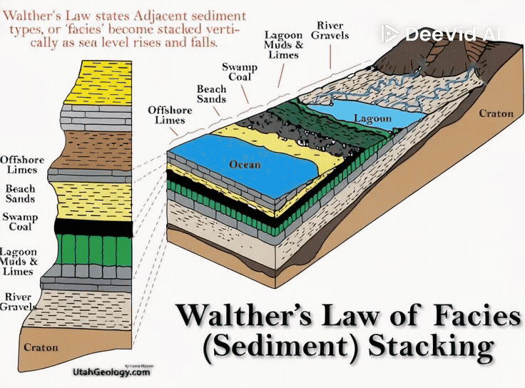
The Geologic formations in Utah tend to be divided primarily by lithology facies. In Geology, a facies is a body of rock characterized by its formation, composition, and fossil content–which usually says something about the environment it was formed in. One particular geologic formation, might have multiple facies. For instance, a famous formation like the Moenkopi, has both near shore tidal facies, and offshore limestone and siltstone facies as well as eolian and coarse grained beach facies. Walther’s Law of facies, states that the strata formed by these separate depositional environments tend to become stacked on top of each other as sea level rises and falls. You’ll see in my interpretations, that I’m always always trying to account for every possible sequence in a depositional system’s environment. The offshore, the nearshore, the backshore, and the river systems. In most major deltaic basins, each of these environments is receiving & preserving sediment simultaneously, stacking these differing sequences on top of each other as sea level fluctuates. Too often I feel like we geologists fail to portray in our historic reconstructions the full dynamics of facies stacking. In the following geologic history, I will attempt to use a lot of pictures and imagery to fully represent the possible depositional environments and facies stacking involved in the formation of Utah’s geologic units.

As you can see in the above illustration, a single depositional basin or shoreline often has four to seven separate facies. As sea level rises and falls, or as deltas prograde out to sea, those facies become stacked vertically in a variety of unique ways. Anytime a geologists stands before the coarse grained sediments of a fluvial (stream or river) deposit, they must ask where did the fine grained sediments in this system end up? Where was the shoreline? And as sea-level rose or fell through time are those deposits stacked above or below the one’s I’m looking at?
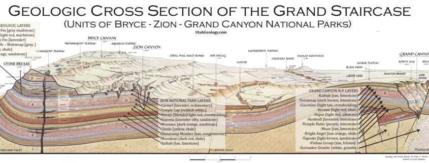
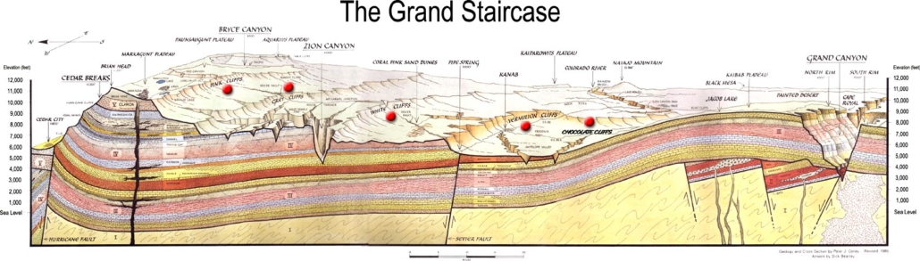
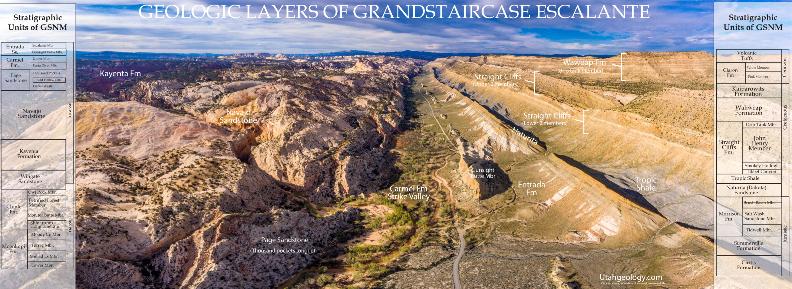
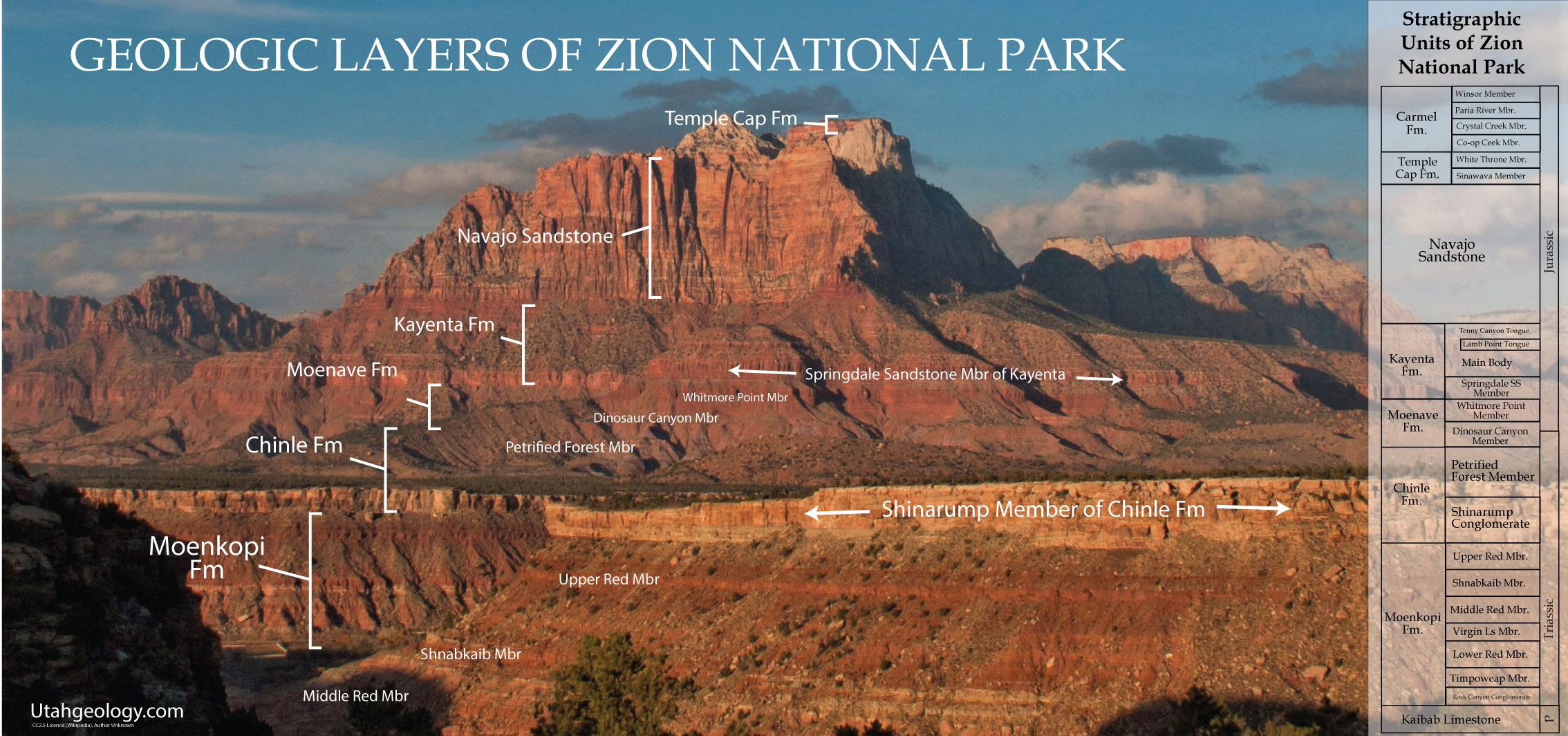
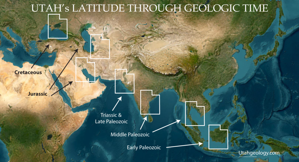
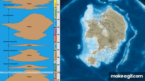
The Grand Staircase of Utah and Arizona
The Grand Staircase refers to an immense sequence of sedimentary rock layers that stretch south from Bryce Canyon National Park and Grand Staircase-Escalante National Monument, through Zion National Park, and into the Grand Canyon National Park. It is perhaps one of the best locations in the world to study Walther’s Law of facies stacking.
In the 1870s, geologist Clarence Dutton first conceptualized this region as a huge stairway ascending out of the bottom of the Grand Canyon northward with the cliff edge of each layer forming giant steps. By travelling from the bottom of the Grand Canyon, through Zion and the Vermillion Cliffs of Grand Staircase Escalante and onto Bryce, Cedar Brakes or the Cenozoic layers of central Utah one can walk essentially the entire rock record of the last 500 million years since complex life began to evolve on the planet in the Cambrian. By studying these layers geologist like myself can reconstruct what the landscape looked like through time.

.
.
.
Pleistocene Paleogeography
0.01 – 2.5 million years ago (mya)
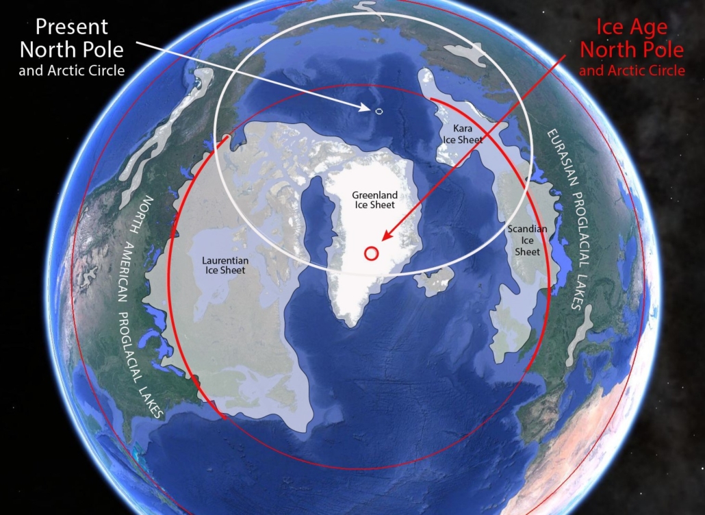
Be sure to check out my article on rapid True Polar Wander for my radical theory explaining Pliestocene Ice Age occilations & polar ice sheet mismatching.
The Pleistocene Epoch, spanning from roughly 2.5 million to 11,700 years ago, transformed Utah into a landscape of alpine glaciers and massive inland seas. While the broader Western Cordillera was being sculpted by the expansion of the Cordilleran Ice Sheet to the north, Utah’s high-altitude plateaus and the Wasatch Range were dominated by local mountain glaciation. In the Grand Staircase and Southwest region, cooler temperatures and significantly higher precipitation—driven by the southward shift of the jet stream—suppressed evaporation and fueled the growth of “pluvial” lakes. The most spectacular of these was Lake Bonneville, an immense body of water covering nearly 20,000 square miles of western Utah. As the climate fluctuated, the shoreline of this prehistoric sea rose and fell, eventually reaching its threshold at Red Rock Pass and catastrophically draining into the Snake River plain. This period of high moisture also radically increased the discharge and sediment-carrying capacity of the Colorado River and its tributaries. These powerful river systems, fed by glacial meltwater from the Uinta and Rocky Mountains, accelerated the incision of the deep canyons we see today, flushing vast volumes of sediment into the Grand Canyon system.
Life in Pleistocene Utah was dominated by a diverse “megafauna” adapted to this cooler, wetter environment. The lush grasslands and riparian corridors of the Southwest region supported herds of Columbian mammoths, ancient camels, and horses, which in turn were hunted by apex predators like the Short-faced bear and the Saber-toothed cat. In the high-altitude forests of the Grand Staircase, giant ground sloths and Muskoxen roamed near the edges of active glaciers. These animals left behind a rich fossil record in the caves and alluvial deposits of the region, providing a snapshot of an ecosystem on the brink of the modern era. However, as the Pleistocene drew to a close and the climate became increasingly arid, the great ice age lakes began to evaporate, leaving behind the Great Salt Lake and Sevier Lake as remnants. This transition triggered the “Great Dearth” or extinction of the megafauna, marking a definitive shift in Utah’s ecology and depositional history toward the desert landscapes that define the Great Basin and Colorado Plateau today.
.
Pliocene Paleogeography
2.5 – 5.3 million years ago (mya)
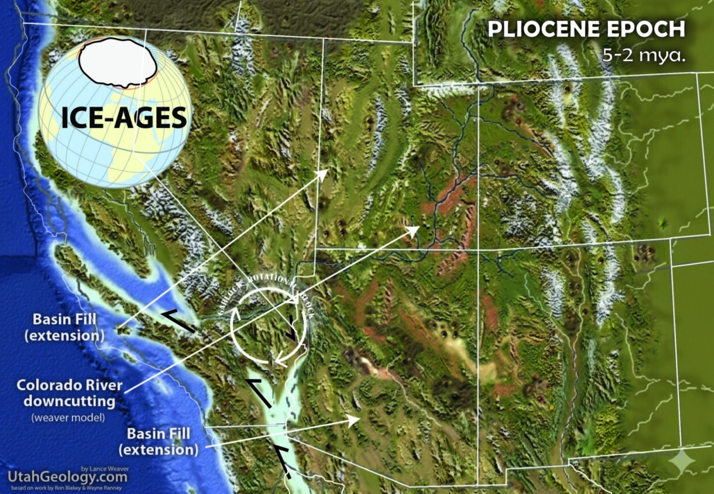
Be sure to check out my article on rapid True Polar Wander for my radical theory explaining Ice Age oscillations & polar ice sheet mismatching. As well as my article on early formation of the Colorado River.
The Pliocene Epoch (approximately 5.3 to 2.5 million years ago) represents a pivotal transition from the “Exotic/non-modern” landscapes of the Miocene to the recognizable, rugged contours of modern-day Utah. Across the Western Cordillera, this period was defined by intense tectonic reorganization. As the Pacific Plate shifted its trajectory, the San Andreas Fault system developed, accelerating the basement rotation of the Colorado Plateau and offsetting the Colorado River as it crossed its periphery & causing one last pulse of explosive volcanism. Plate reorganization triggered a massive acceleration of Basin and Range faulting. In western Utah, the crust continued to stretch and crack along north-south trending normal faults, causing massive blocks of the earth to drop into valleys (grabens) while leaving others standing as jagged mountain ranges (horsts). This extension not only created the characteristic “washboard” topography of the Great Basin but also helped “tilt” the Colorado Plateau, accelerating the incision of the Colorado River system as it re-routed southward to reach the newly formed Gulf of California.
In the Grand Staircase and Southwest region, the Pliocene was a time of dramatic climatic cooling. Onset of Pleistocene glaciation was beginning in the high-altitude peaks of the Uintas and the Wasatch. This shifting climate transformed the lush, subtropical forests of earlier epochs into expansive, arid grasslands and shrub-steppes. This “savanna-like” environment supported a spectacular array of Pliocene fauna. Utah was home to early species of Borophagus (bone-crushing dogs), giant camels, and the ancestral forms of horses and mastodons. Toward the end of the Pliocene, the “Great American Biotic Interchange” allowed South American species, like the giant ground sloth and glyptodonts, to begin their northward trek. As river systems like the Virgin and Sevier adjusted to the dropping base levels caused by Basin and Range extension, they deposited the gravels and basin-fill sediments that today form the high benches of the Grand Staircase, preserving a record of a world poised on the edge of the most recent Great Ice Age..

Miocene Paleogeography
5.3 – 23 million years ago (mya)
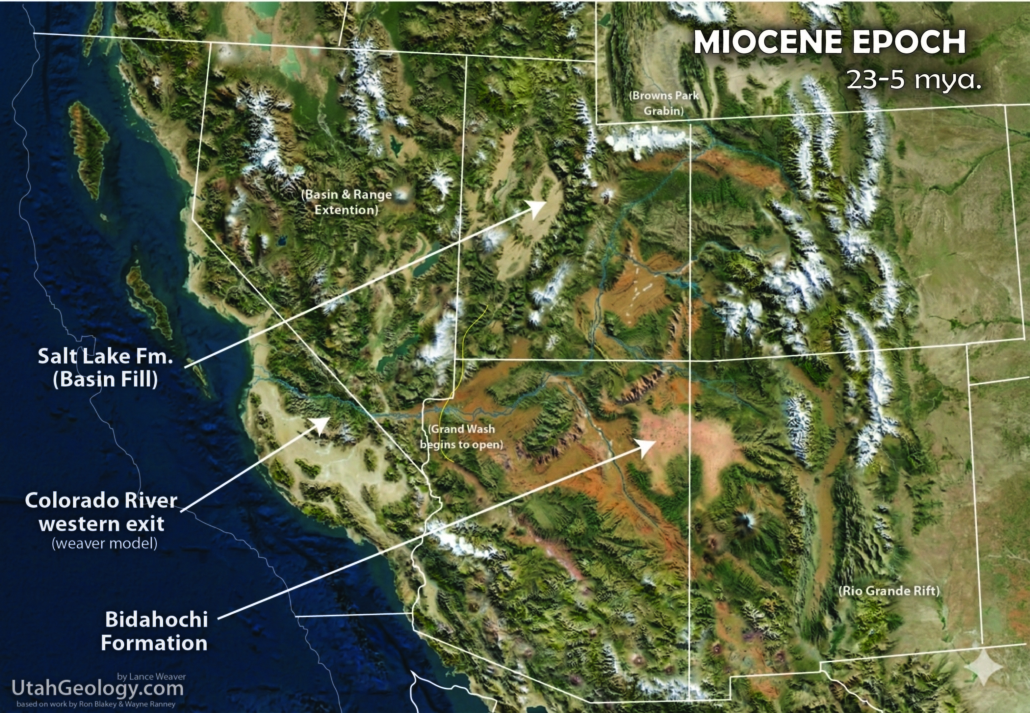
Be sure to check out my article on early formation of the Colorado River.
The Miocene Epoch marked a fundamental tectonic “reboot” for Utah and the surrounding region, shifting the Navadan landscape from a high, unified mountain range like the Andes or Spatsizi Plateau of BC into the rugged, fragmented topography we recognize today. This era saw the onset of the Basin and Range extension, a massive crustal stretching that pulled the Earth’s crust apart, creating north-south trending mountain blocks and deep, sinking basins. Mafic extrusive volcanism began to exploit these tears bringing Hawaii-style volcanism throughout the region. These newly formed collapsed valley’s were rapidly filled with thick sequences of sediment, most notably the Salt Lake & Sevier River Formations, (catch all terms for Basin-fill deposits) which captured a detailed record of the developing valleys. To the south, the Grand Wash Trough began to open, serving as a critical structural gateway where sediment accumulation provided early evidence of the profound displacement that would eventually allow the Colorado River to deeply incise the plateau. Simultaneously, the eastern edge of the region was impacted by the opening of the Rio Grande Rift, a major tectonic “tear” that further fractured the continental interior.
Volcanism played a dominant role in this Miocene transformation, particularly to the north, where a migrating volcanic arc and hot spot activity began carving the Snake River Plain. This volcanic pulse coincided with a regional uplift that fundamentally altered drainage patterns, triggering the beginnings of incision on the Colorado Plateau. As ancestral river systems struggled to adjust to this rising landmass, they deposited the Bidahochi Formation, a sequence of lacustrine and fluvial sediments that captured the final moments of a sluggish, pre-canyon landscape before the “great integration” of the Colorado River. This period represents the transition from a world of gentle gradients and slow-moving water to one of aggressive erosion, where the high-altitude desert began the first stages of the deep carving of its iconic canyons.
A large transform fault system, the San Andreas, was created. Blocks moving northwest along the Pacific side of the fault were caught in a bend of the fault system in southern California. These blocks were rotated in clockwise fashion to form the Transverse Ranges. Basement interplay on the fault helped rotate the Colorado Plateau & Garlock micro-block causing confusing localized compressional folding in an otherwise transverse-extensional regime.
.
Oligocene Paleogeography
23 – 33.9 million years ago (mya)
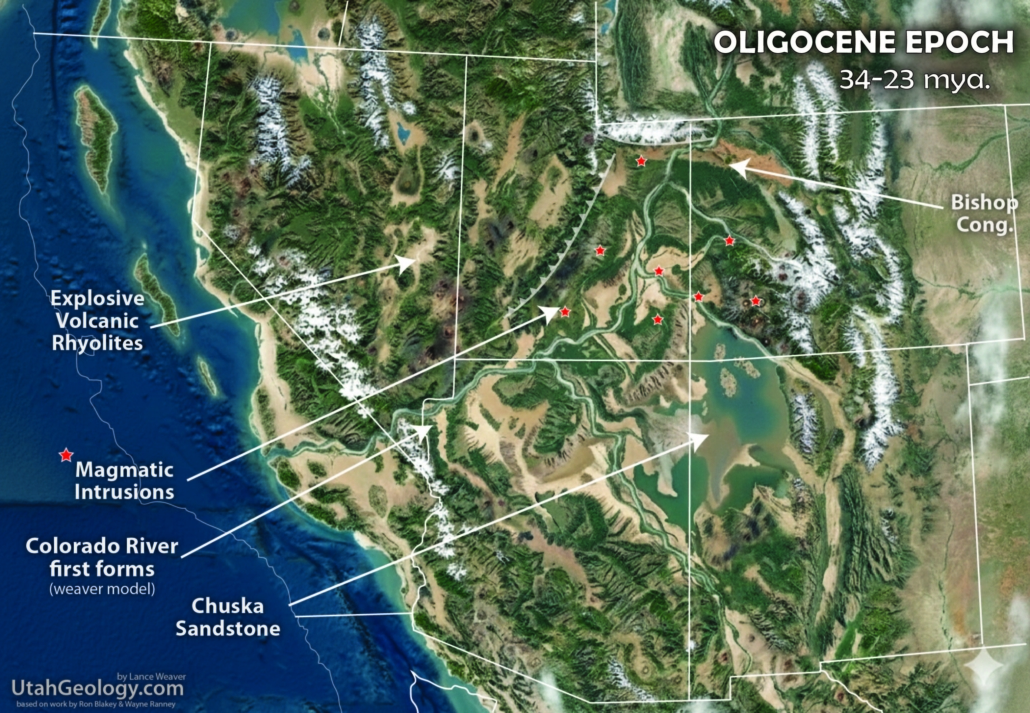
The Oligocene Epoch in Utah and the surrounding region was a period of staggering subterranean violence and surface leveling. This era was defined by the peak of the “ignimbrite flare-up,” where the crust was perforated by numerous supervolcanoes and massive intrusive magma bodies. These rising plutons were emplaced beneath the surface, forming the cores of laccolithic and batholithic mountains such as the Pine Valley, Henry, Abajo, and La Sal ranges, which would largely be exposed by much later erosion. As the final pulses of the Laramide Orogeny subsided, the rugged topography of the earlier Eocene began to soften. The vast lake systems that had dominated the landscape, like Lake Uinta, is fully filled with a massive influx of sediment and volcanic ash, transforming the entire Colorado Plateau into a broadly eroded, high-altitude plain similar in appearance to the modern-day basins of Wyoming.
Amidst this flattening landscape, the Bishop Conglomerate and Chuska Sandstone stand as silent witnesses to a massive erosional pulse that swept across the plateau. These deposits suggest a tectonic pulse leading to a high-energy environment where debris was being shed from lingering highlands and transported across vast distances. This geologic backdrop provides a compelling setting for my ‘fill-to-spill’ theory of the proto-Colorado River finding an Oligocene outlet to the pacific through a low pass in the southern Nevadan/Arizonan Arc to the Pacific (read full article here). As the Central Utah Thrust Zone continued its eastward push, it acted as a tectonic wedge, pushing drainage patterns from the filled Eocene lake systems southeastward and forcing the emerging river toward its modern trajectory. The periods in which each lake basin stops retaining sediment marks the exact moment that each basin finds an outlet into the newly developed Colorado River system and starts transporting sediments out of the old endoheric lakes and toward the Pacific Ocean.
.
Eocene Paleogeography
33.9 – 56 million years ago (mya)
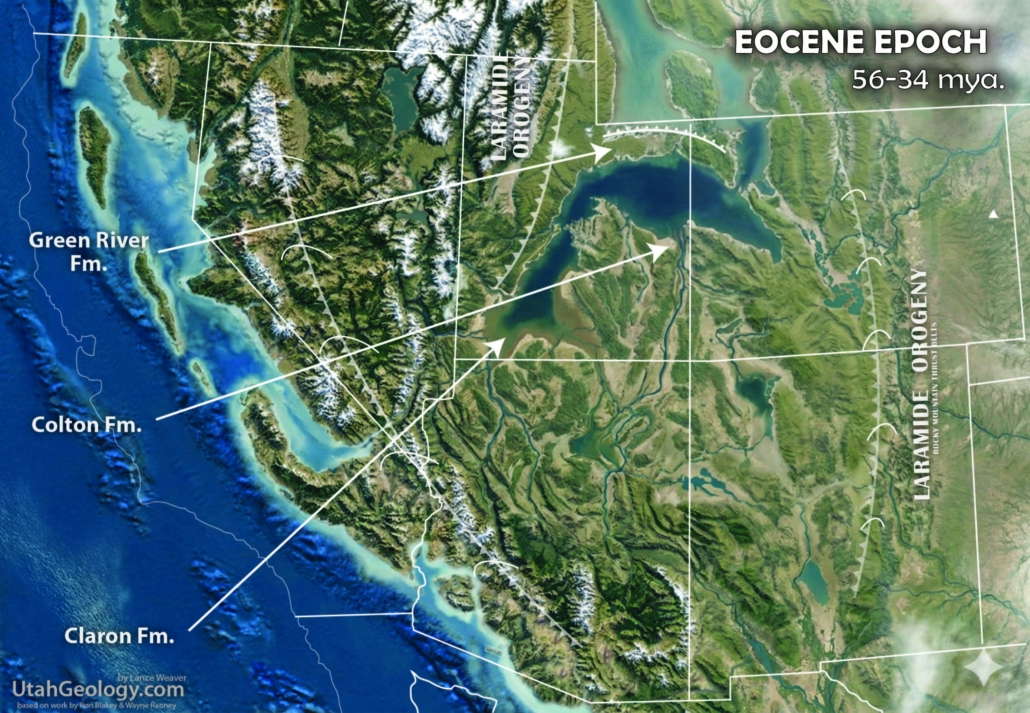
The Eocene Epoch in Utah and the surrounding region was defined by a massive “ponding” of the continent as the final structural movements of the Laramide Orogeny partitioned the landscape into isolated, sinking basins. As the Uinta and Wyoming mountain arcs rose, they effectively severed the old northward drainage routes to the retreating Cretaceous Seaway, creating some of the largest inland bodies of water in Earth’s history. This period is recorded in the vibrant, oxidized sediments of the Claron Formation, which formed the foundations of Bryce Canyon, and the world-famous Green River Formation. The latter represents a vast system of perennial lakes, such as Lake Uinta and Lake Goshute, where fine-grained muds and organic matter accumulated in quiet, subtropical waters, preserving an exquisite record of Eocene fish, plants, and insects.
As the epoch progressed, the rising mountains of the landscape began to transition from these tranquil lacustrine environments toward a more high-energy, volcanic world. The Duchesne River Formation marks the closing of the lake cycles, as river systems began to prograde across the drying basins, burying the old lakebeds under thick sequences of sand and silt. To the north, the Absaroka Volcanic Supergroup erupted with colossal force throughout the Eocene, shedding massive lahars and ash across Wyoming and northern Utah. Similiar voclanoes erupted in the San Juan Mountains of Colorado. This regional activity coincided with major shifts further west; while Utah was ponding, California was experiencing the subduction of the Farallon Plate, which drove the “Laramide” deformation deep into the interior. By the end of the Eocene, the accumulation of volcanic debris and tectonic uplift had begun to fill the basins to the brim, setting the stage for the massive erosional pulses and the beveling of the landscape that would characterize the succeeding Oligocene.
It’s during the latest Eocene or possibly Oligocene that I believe the Colorado River first found its way through a low southwest mountain pass into the Pacific Ocean (read my article here). This transition is evidenced by the point in which the Eocene lake systems ‘mysteriously’ stop accumulating sediments. The exact point can be hard to date in the non-fossiliferous deposits of the Claron, but the end of these massive depositional lake systems is really the only convincing evidence of drainage reversal from the Mesozoic north-flowing river systems to the modern south-flowing systems.
.
Paleocene Paleogeography
56 – 66 million years ago (mya)
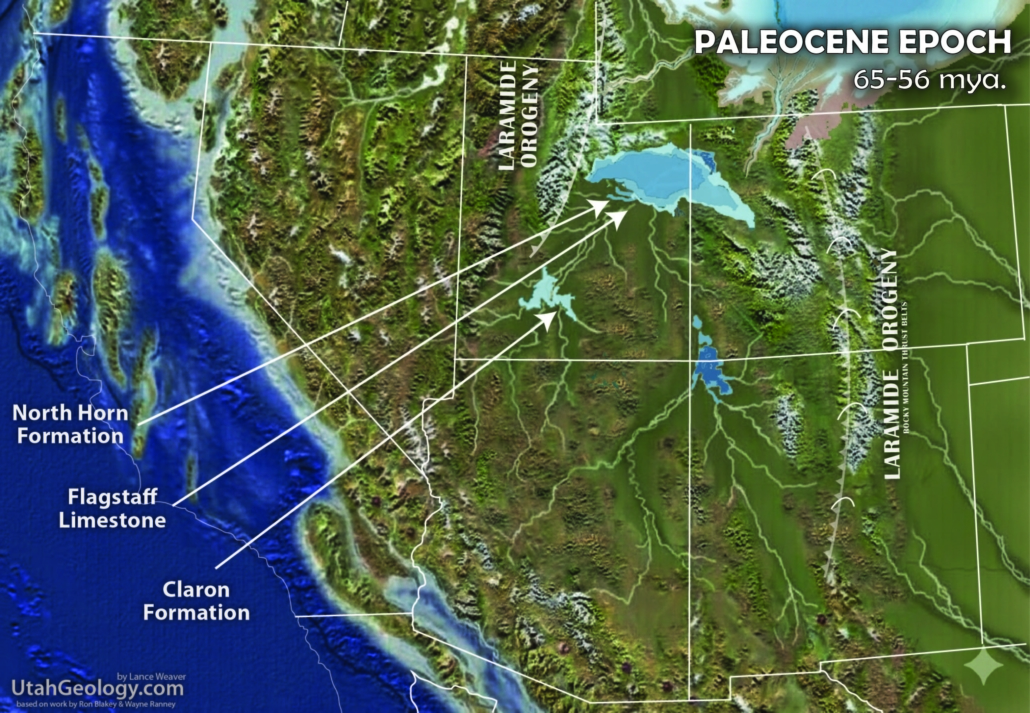
The Paleocene Epoch (approximately 66 to 56 million years ago) marked the definitive transformation of the American West from a coastal marine environment into a rugged, terrestrial interior. As the Laramide Orogeny intensified, the Western Interior Seaway made its final, permanent retreat from Utah, leaving behind a vast, low-lying coastal plain that was rapidly being buckled by tectonic forces. To the west, the Sevier fold-and-thrust belt continued to exert pressure, while further east, deep-seated basement rocks began to arch upward, giving birth to the Colorado Plateau and the modern Rocky Mountains. This massive topographic rise fundamentally reconfigured the continent’s plumbing; the ancestral river systems, which for millions of years had flowed northeast into the Cretaceous sea, found their paths blocked by the rising Laramide highlands. These diverted waters were trapped in internal basins, eventually fueling the great lacustrine systems of the Eocene, while the rising Colorado Plateau began its long journey of epeirogenic uplift.
The most dramatic evidence of this tectonic upheaval is found in the “clastic aprons”—massive, coarse-grained conglomerate deposits shed from the rapidly eroding mountain fronts. In Central Utah, the North Horn & Grand Castle Formations stands as a monument to this period, consisting of thick, bouldery conglomerates that represent high-energy alluvial fans and braided river systems. These have direct equivalents in Northern Utah, such as the Wasatch Conglomerate and the Syncline Hill deposits. Across the border in Colorado, the rising Rockies produced striking equivalents in the Telluride Conglomerate and the Ohio Creek Formation, as well as the lower portions of the Animas Formation. These conglomerate “aprons” reflect a time of extreme topographic relief, where the newly born Rockies and the High Plateaus of Utah were shedding thousands of feet of debris into adjacent sinking basins. This depositional regime signals the end of the marine-dominated Mesozoic and the start of the high-energy, mountain-building Cenozoic that defines the modern Cordilleran landscape.
The Paleocene also marks the beginning of what I dub ‘the Great Reversal’, where the southward flowing Colorado River system begins to evolve from Mesozoic north-east rivers. Major drainage reversals always leave evidence in the form of fill-to-spill lake sediments as the basins look for a new exit, and this is exactly what we see in the Paleocene & Eocene of Utah and Wyoming. Although the Miocene dated ‘Bidahochi Formation’ suggests that smaller sub-basins, like that created behind the Arizona/New Mexico Defiance upwarp might not have reversed and established drainages until much later, most of the Colorado Plateau uplifts and drainages would have had their beginnings in the Paleocene. It follows, then that as the Nevadan/Arizonan Arc collapsed in the Mid to Late tertiary, the proto Colorado River had already established an outlet to the Pacific, allowing it to maintain course through canyons of the Navadaplano and the gentle rising ‘Laramide’ folds of the Colorado Plateau
.
Latest Cretaceous Paleogeography
72 – 66 million years ago (mya)
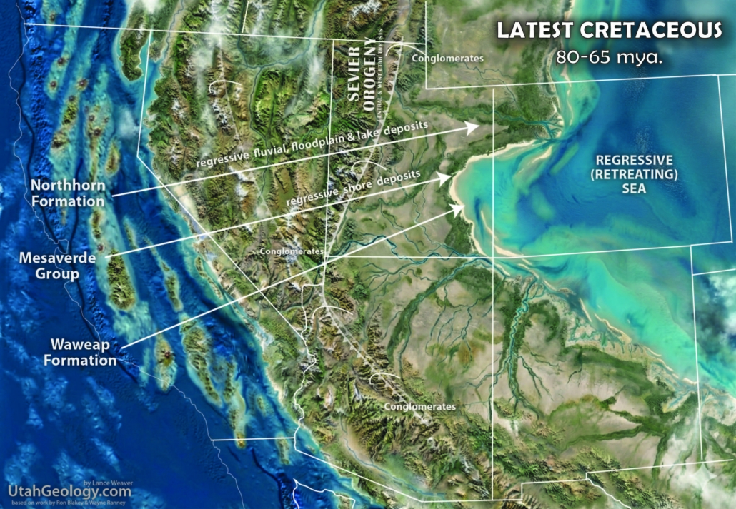
During the Late Cretaceous (approximately 100 to 66 million years ago), Utah was the stage for a dramatic geological tug-of-war between rising mountains and encroaching seas. To the west, the Sevier Orogeny was in full swing, a tectonic event where oceanic plates subducting beneath the North American margin buckled the crust, pushing up the massive Cordilleran mountain chain. This highland, known as the Western Cordillera, shed staggering volumes of sediment eastward into a deepening structural trough. Simultaneously, rising global sea levels and crustal subsidence allowed the Western Interior Seaway to flood the continent, bisecting North America from the Arctic to the Gulf of Mexico. Utah sat on the dynamic western shoreline of this sea; as the mountains rose and eroded, the resulting “clastic wedge” of sediment pushed the coastline back and forth, creating a complex patchwork of coastal lagoons, swampy lowlands, and vast floodplains.
In the Grand Staircase and Southwest region, this environmental dance is perfectly preserved in the layers such as the Mesa Verde Group and equivalent Wahweap & Kaiparowits Formations. During this era, southern Utah was a lush, coastal plain crisscrossed by massive, perennial river systems flowing from the Sevier highlands toward the seaway. The Wahweap Formation, in particular, records a landscape of sluggish, meandering rivers and high-diversity wetlands that supported a “golden age” of dinosaur evolution, including unique species of horned ceratopsians and duck-billed hadrosaurs. As these river systems reached the coast, they deposited the thick sandstones of the Mesa Verde Group, representing ancient beach and delta environments. These deposits were frequently buried by the dark, marine muds of the Tropic Shale or Mancos Shale whenever the seaway transgressed inland. This constant shifting of the shoreline not only created the coal-rich swamps found in the Straight Cliffs Formation but also established the unique preservation conditions that make Utah’s Late Cretaceous record one of the most complete and scientifically significant in the world.
The Sevier orogeny was at its climax. Regional metamorphism affected western Arizona and eastern California. Paleozoic and Mesozoic sandstone, mudstone, and limestone were metamorphosed to quartzite, schist, and marble. The west coast was marked by strongly oblique collision between the oceanic and continental plates and right-lateral transform faults transported pieces of Wrangellia and other terrains northward along the edge of North America. The Franciscan forearc complex was a broad accretionary prism that was constantly being deformed by complex stresses into a melange’.

.
Middle Cretaceous Paleogeography
125 – 89 million years ago (mya)
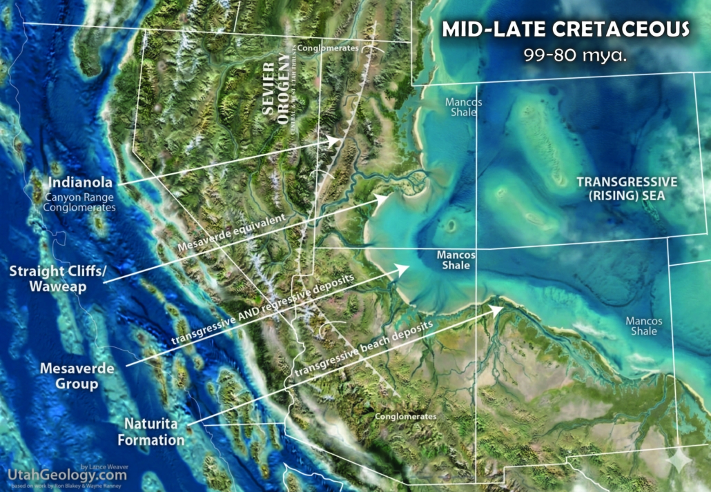
The Middle Cretaceous (approximately 125 to 95 million years ago) was a period of profound tectonic transition that set the stage for the modern American West. To the west, the Nevadaplano—a high-altitude, Andean-style plateau—began to rise as the Farallon Plate subducted beneath the North American margin. This subduction fueled a massive volcanic arc, driving the emplacement of the great granitic plutons that now form the Sierra Nevada Batholith. Just offshore, the colossal Shatsky Rise oceanic plateau was likely interacting with the subduction zone, potentially shallowing the subduction angle and accelerating the uplift of the Western Cordillera. This mountain-building event, the Sevier Orogeny, created a topographically high “hinterland” in Nevada that shed vast amounts of sediment eastward. At the same time, the Western Interior Seaway began its first major incursions into the continental interior, creating a humid, lowland environment in Utah that stood between the rising peaks and the encroaching sea.
In the Grand Staircase and Southwest region, this era is best recorded in the Cedar Mountain Formation. This formation represents a massive, low-gradient river system flowing out of the Nevada highlands, characterized by broad floodplains and sluggish, meandering streams. The flora was in the midst of a revolutionary shift; while ferns, cycads, and conifers still dominated, the first angiosperms (flowering plants) were beginning to colonize the riverbanks. The fauna was equally spectacular, featuring a “transitional” dinosaur assemblage that included the feathered dromaeosaur Utahraptor, the massive iguanodontian Tenontosaurus, and early ankylosaurs. These animals navigated a landscape of seasonal wetlands and ash-dusted plains, as volcanoes in the west frequently blanketed the region in silicic ash. As the seaway continued to rise toward the end of the Middle Cretaceous, these terrestrial river systems were eventually drowned by the advancing marine waters, leading to the deposition of the Naturita/Dakota Formation and the first widespread marine shales of the Mancos Sea.
.
Early Cretaceous Paleogeography
145 – 125 million years ago (mya)
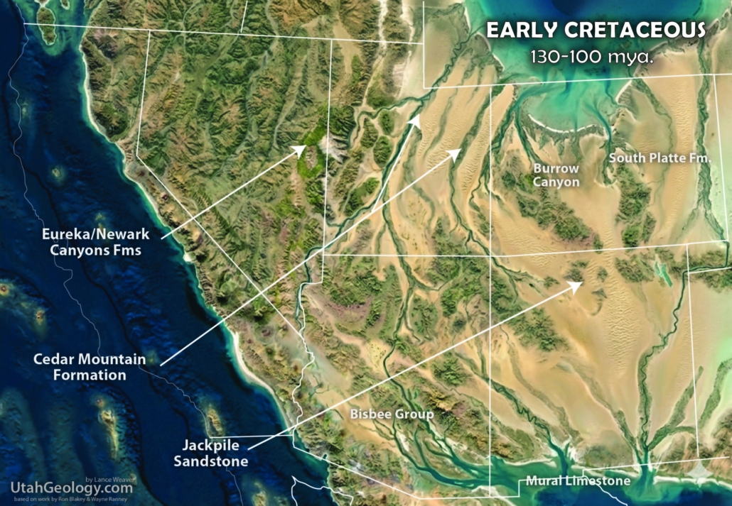
he Early Cretaceous (approximately 145 to 100 million years ago) was a period of profound tectonic and climatic transition in Utah, characterized by a significant “gap” in the rock record known as the J-K unconformity. Following the retreat of the Jurassic Sundance Sea, the Western Cordillera began to transform under the initial stages of the Sevier Orogeny. To the west, the Nevadaplano began its topographic ascent, fueled by the subduction of the Farallon Plate. This subduction generated a massive volcanic arc, with the early emplacement of granitic plutons that would eventually form the core of the Sierra Nevada and Peninsular Ranges batholiths. While the regional basin was widening in anticipation of the future Western Interior Seaway, much of Utah experienced a period of non-deposition or active erosion. The uplift of the Mogollon Highlands to the south and the nascent Sevier fold-and-thrust belt to the west created a “bypass” environment; instead of accumulating in Utah, sediments were transported north and east into deeper basins in Wyoming and Canada, leaving a temporal lacuna between the Jurassic Morrison Formation and the later Cedar Mountain Formation.
Global conditions during this “missing” interval were surprisingly volatile. Despite the Cretaceous being generally viewed as a “greenhouse” world, evidence suggests significant climate oscillations and even transient glaciation. Research has identified “cold snaps” with eustatic sea-level drops, most notably evidenced by ice-rafted debris and quartzite dropstones in the Cameros Basin of Iberia during the Hauterivian (133–129 Ma) and again in the late Aptian–early Albian (115–110 Ma). These dropstones indicate the presence of continental glaciers reaching sea level even at mid-latitudes. In the Grand Staircase and Southwest region, this era is marked by the enigmatic “Buckhorn Conglomerate” at the base of the Cedar Mountain Formation, which represents the return of high-energy fluvial systems as the regional subsidence finally overcame the period of uplift. (Were glaciers forming in the high Navadaplano mountains?) These gravel-heavy river systems, flowing from the Nevada arc, signaled the end of the long Early Cretaceous hiatus and the beginning of the massive sediment loading that would eventually drown the region under the Cretaceous Seaway.
Trans-etensional basins in southern Arizona and California were the sites of thick marine and continental deposition. The fore arc-trench off the west coast was the site of the famous Franciscan melange’. The Great Valley sequence was deposited in the fore arc basin and the Sierra Nevada batholith complex formed in the bowels of the arc.
.
Late Jurassic Paleogeography
163 – 145 million years ago (mya)
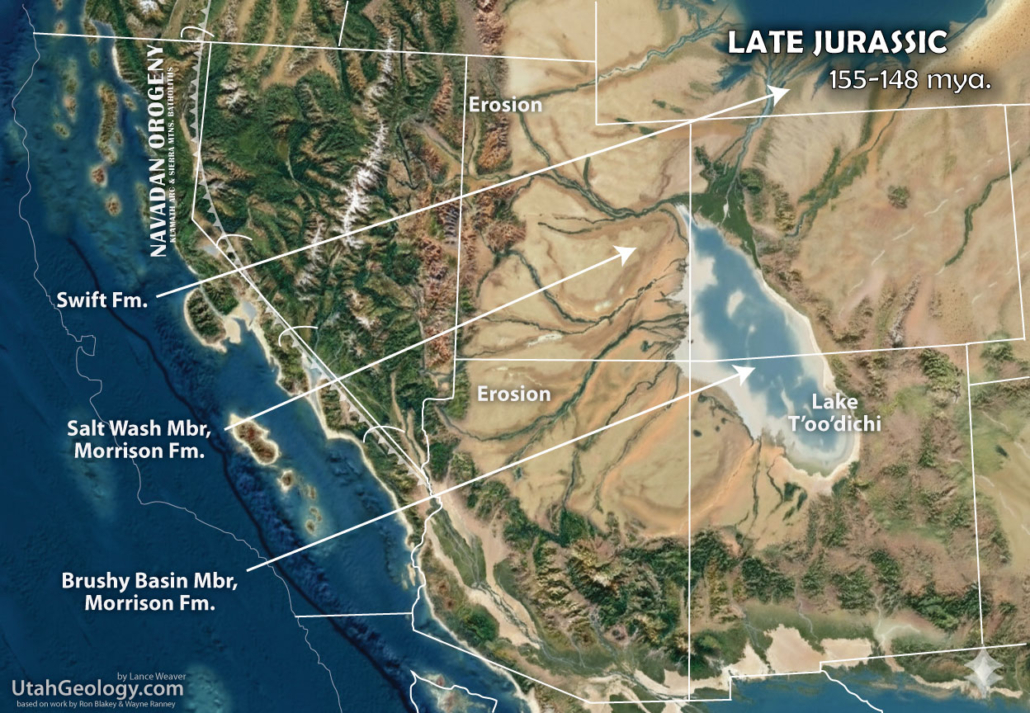
The Late Jurassic (approximately 163 to 145 million years ago) marked a tectonic and environmental pivot for the Western Cordillera as the Sundance Sea made a final retreat to the north. This regression was driven by the onset of the Nevadan Orogeny, a massive mountain-building event triggered by the subduction of the Farallon Plate. As the proto-Sierra Nevada volcanic arc fired up, the Nevadaplano began to rise, creating a high-altitude hinterland that shed enormous volumes of sediment eastward. This debris was funneled into a vast, subsiding foreland basin that encompassed much of Utah. In the Four Corners region, this tectonic loading likely reactivated the older Paradox Basin, causing it to re-subside and accommodate some of the thickest exposures of the resulting Morrison Formation. Centered in this subsiding “sump” was the massive, alkaline Lake Toodichi, a playa system that covered thousands of square miles and left behind the distinct smectite-rich mudstones that characterize the Brushy Basin Member today.
The depositional environment of the Morrison Formation is best understood through modern analogs like the Rio Grande Delta or the sediment-heavy plains of the Tampico-Misantla (Monterrey/Tamaulipas) region. Here, high-energy river systems carrying gravels and sands from the distant Nevadan highlands emptied into a broad, low-gradient coastal plain. Much like the modern Gulf Coast, these rivers meandered through seasonal wetlands and semi-arid floodplains, creating a “distributive fluvial system” that supported an explosion of terrestrial life. This was the undisputed age of giants; the Grand Staircase and Southwest regions were populated by iconic sauropods like Apatosaurus and Diplodocus, alongside predators like Allosaurus. These animals navigated a world of ephemeral streams and soda-rich lakes, leaving behind one of the most famous fossil records in history before the tectonic shifts of the Early Cretaceous eventually truncated the sequence.
Stresses related to the opening of the Gulf of Mexico oceanic basin caused oblique, transtensional basins to form across the southwest portion of North America. The collapse of Stikine arc against Quesnell and perhaps the initial collision of Wrangellia trigger the first phase of the Nevadan orogeny.

.
Middle Jurassic Paleogeography
174 – 163 million years ago (mya)
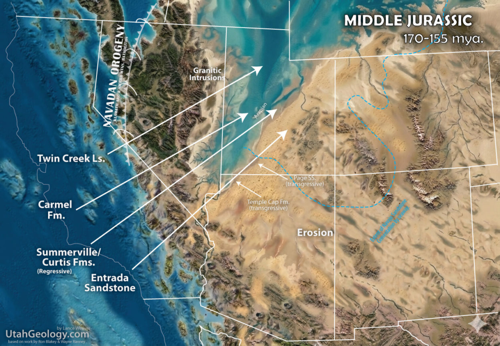
The Middle Jurassic (approximately 174 to 163 million years ago) saw a shift in Utah’s landscape as the vast, arid “sand seas” of the Early Jurassic Navajo Sandstone were inundated by the first major pulses of the Sundance Sea. This marine incursion was driven by a global rise in sea level and the early tectonic loading of the Sevier foreland trough. To the west, the Nevadaplano was in its infancy—a low-elevation upland just beginning to crustally thicken as subduction intensified along the margin. In California, the magmatic arc was firing up, while in Arizona and Colorado, the landscape remained largely terrestrial. However, in Central Utah, a massive structural trough developed, creating a basin trap for sediment. This area experienced maximum subsidence, leading to the deposition of the Carmel Formation and the Arapien Shale. These units are remarkably thick and laden with gypsum and other evaporites, recording repeated restricted, shallow-tidal flat and lagoon environments where seawater frequently evaporated in the sweltering Jurassic heat, leaving behind vast salt and sulfate deposits.
The stratigraphic record of this era is defined by the rhythmic advance and retreat of the Sundance waters. The Carmel Formation represents the initial transgression (the “coming in”) of the sea, while the subsequent Entrada Sandstone captures a massive coastal dune system that existed alongside the fluctuating shoreline. A striking modern analog for the Entrada is found in the Persian Gulf or the Caspian Sea, where towering desert dunes migrate directly into the marine environment. As the sea regressed (the “going out”), it left behind the tidal flats and sabkhas of the Curtis Formation and the Summerville Formation. The Summerville, with its distinct, thinly bedded chocolate-and-white siltstones, represents the final, quiet withdrawal of the Middle Jurassic sea into restricted coastal lagoons. The interplay of the sandy shorelines of the Curtis and muddy tidal flats of the Summerville can be hard to track. The lateral facies equivalents interfinger extensively, representing a shifting mosaic of environments along the edge of the shrinking Sundance Sea. Together, each of these formations in the Grand Staircase and Southwest region document a world caught between the relentless march of wind-blown sands and the sluggish, salty tides of a proto-epicontinental sea.
Wrangellia, the colossal “island continent” of basaltic rock begins to slam into the western margin of North America. Debatably originating south near Baja, and being transported northward along the proto-San Andreas system to Canada & Alaska. Elements of the McCloud arc collapse against the continent and thrusting in Nevada creates uplands in the Sonoman Orogeny.
.
Early Jurassic Paleogeography
201 – 174 million years ago (mya)
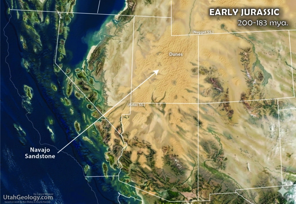
The Early Jurassic (approximately 201 to 174 million years ago) in Utah was defined by the dramatic transformation of a wet Triassic, river-dominated landscape into the largest sand sea, or erg, in North American history. This shift was driven by the intensifying Cordilleran volcanic arc to the west and the early arrival of exotic terranes like Wrangellia. As these oceanic island arcs collided with the western margin, they began to push up a topographic highland—the nascent Nevadaplano—which acted (at least in part) as a wind and rain shadow. More importantly, this tectonic “shove” created a subsiding foreland basin that fundamentally altered the continent’s drainage. The massive Chinle river system, which had previously dominated the Triassic, was pushed from its early route in the Southwest, gradually northeastward toward Wyoming. This northward migration of the major water sources left arid muddy deserts in its wake setting the stage for a prolonged period of wind-driven deposition.
The stratigraphic record of this transition is beautifully preserved in the interfingering layers of the Glen Canyon Group. The process began with the Wingate Sandstone, which represents the first pulses of desert dunes encroaching upon the migrating Chinle river systems. Between these dunes, the Moenave and Kayenta Formations record the last gasps of fluvial and lacustrine environments; these siltstones and sandstones represent braided rivers and ephemeral lakes that struggled to persist as the climate dried. Eventually, as the “Chinle” river systems completely exited the region, the landscape was surrendered to the wind. The result was the Navajo Sandstone, a massive accumulation of cross-bedded recycled quartz sand that reached thicknesses of over 2,000 feet in some areas. This “Great Erg” persisted for millions of years, a Sahara-like wilderness of shifting dunes that stretched from Arizona to Wyoming. It was only the eventual transgression of the Sundance Sea in the Middle Jurassic that finally halted the wind’s work, providing the moisture and desolved-lime cement necessary to turn these immense sand piles into the iconic red-rock cliffs of Zion and the Grand Staircase.
A good modern example of this system is the Indus River of Pakistan, Amu Darya River of Turkmenistan or even the Tigris/Euphrates of the Persian Gulf. Each of these divided river systems is being pushed laterally by rising adjacent mountain systems. As they move laterally or obliquely to the sea, the fluvial systems transition to (and are covered by) marginal lacustrine and dune systems. The reasons why these river systems divide, is complex. But between the river’s main branch (Chinle) and child branch (Kayenta) is a complex system of interfingering lakes and dunes (Moenave & Wingate) which will eventually be covered by raising sea level to cement all the buried porous sands in the system to rock.
.
Late Triassic Paleogeography
242 – 201 million years ago (mya)
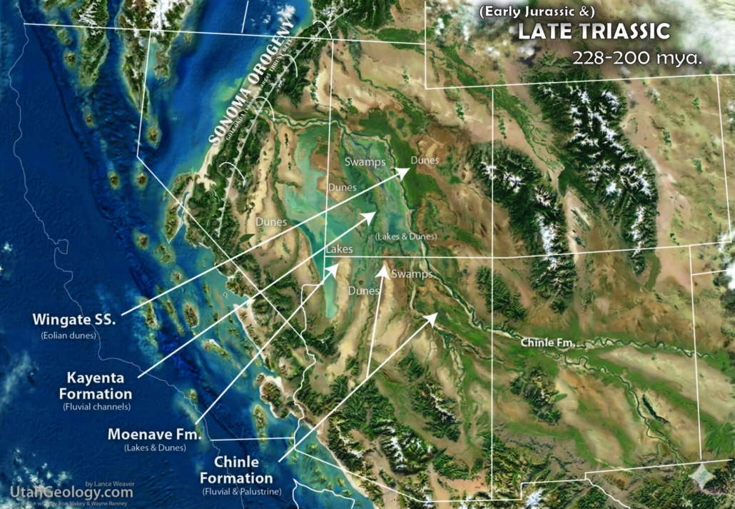
The Late Triassic (approximately 237 to 201 million years ago) in Utah was defined by the transition from a passive marine margin to a rugged, terrestrial interior. This shift was fueled by the intensifying Cordilleran volcanic arc to the west. As the Farallon Plate subducted, it generated a massive “tectonic shovel” that loaded the crust, creating a north-east migrating foreland basin. This subsidence fundamentally rerouted the western continent’s primary river systems. The Chinle Formation represents an ancient transcontinental “Amazon” fed by the rising Mogollon Highlands to the south and the distant ancestral Appalachians to the east. These powerful river systems were progressively pushed northward by the rising volcanic arc and the shifting basin floor, prograding across the old Permian Kaibab Limestone platform. This was a landscape dominated by floodplains, enormous log jams of silica-saturated wood from volcanic ashes, and early dinosaurs like Coelophysis navigating riverbanks lined with giant horsetails and cycads.
While the “Chinle” name is standard across the Colorado Plateau and the Grand Staircase, this massive sediment wedge takes on different identities as it stretches toward the edges of the Cordillera. In Nevada, equivalent strata are found in the Heizer and Cane Spring Formations, representing distal volcanic influences from the active arc. To the north in Idaho and Wyoming, the system transitions into the Anchorage and the Bell Springs Member of the Nugget or Stanaker Formations. These northern equivalents record the furthest reach of the Chinle’s fluvial influence before it interfingered with the tidal environments of the Idaho-Wyoming trough. Across the entire region, the Chinle exhibits a striking “thickness tug-of-war.” It thins to a mere sliver against the Ancestral Rockies (the Uncompahgre Uplift), where active tectonic rising caused the Tr-3 unconformity to carve deep into older strata. Conversely, it thickens significantly in the south and west, where the subsiding basin acted as a “sump” for thousands of feet of volcanic ash and river-borne silt, creating the colorful, painted-desert mudstones we see today in the Petrified Forest and the San Rafael Swell.
.
Early Triassic Palegeography
251 – 242 million years ago (mya)
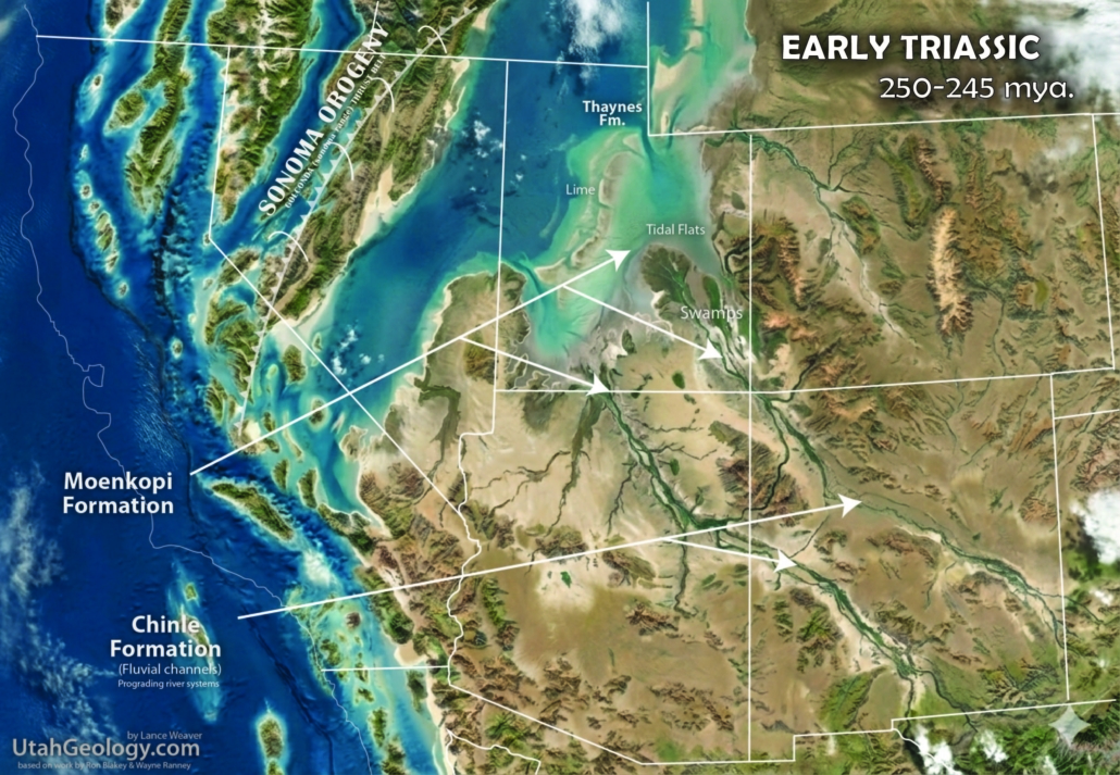
The Early Triassic (approximately 251 to 247 million years ago) saw the Permian world collapse into a new tectonic regime. With the retreat of the Kaibab Sea, was left a vast, low-gradient platform where the Moenkopi Formation was deposited upon a 10-20 million year long unconformable surface).
The stratigraphic record of this era is defined by the massive thickness variations between the Moenkopi and its northern marine equivalents. In the Grand Staircase, the Moenkopi records shallow marine pulses, tidal mudstones, and “candy-striped” evaporites deposited on a flat shelf. However, as one moves northwest into the deeper Cordilleran trough of northern Nevada, southern Idaho, and Wyoming, these red-beds grade into the fully marine Dinwoody and Thaynes Formations which mark the marine bay into which Chinle & Moenkopi sediments emptied. While the Moenkopi in Southwest Utah represents restricted tidal flats, the Thaynes is a robust marine unit thick with ammonoids and limestone. The total thickness of this sequence explodes to the west, filling the deep basins created by Sonoman loading. By the Middle Triassic, the sea regressed a distance, leaving a weathered, unconformable surface. This hiatus was eventually “paved over” by the Chinle Formation (by the same rivers feeding sediment to the Moenkopi), as high-energy rivers carrying the Shinarump Conglomerate flowed toward the northwest from rising volcanic southern and eastern highlands which had been uplifted in the Wichita Orogeny, burying the old marine shelf in a sea of colorful, volcanic-rich fluvial muds.
This landscape was shaped by the ongoing Sonoman Orogeny, as the Stikine and Quesnell elements of the McCloud Arc collided with the margin, causing the Havallah back-arc basin to collapse. As this “oceanic squeeze” occurred, the Cache Creek forearc complex was trapped between arc elements, driving the initial uplift in Nevada. To the east and south, the final stages of the Wichita Orogeny (part of the Ancestral Rockies) and the subsidence of the Permian Basin in Texas and New Mexico reconfigured continental drainage. These far-field stresses established a new river and sediment regime that funneled debris toward the Northwest, where the shoreline of the Panthalassic Ocean rhythmically oscillated across Utah.

.
Late Permian Paleogeography
298 – 251 million years ago (mya)
The Middle to Late Permian (Guadalupian epoch, approx. 273–259 Ma) in Utah represents the final, grand marine transgression of the Paleozoic Era before the great “Great Dying” extinction. Across the Western Cordillera, the margin remained relatively passive (ie. no deformation), characterized by a vast, shallow-water carbonate shelf that dipped gently toward the Panthalassic Ocean. The Kaibab Limestone serves as the capstone of this era, representing a warm, shallow epicontinental sea teeming with life. In the Grand Staircase and Southwest region, the Kaibab is famous for its silicified fossils, including brachiopods, bryozoans, crinoid stems, and “Productid” shells that often weather out of the cherty limestone. As you move north and east, the Kaibab undergoes a facies change into its lateral equivalent, the Black Box Dolomite of the San Rafael Swell. This transition reflects a move from the open-marine shelf into more restricted, magnesium-rich hypersaline waters where dolomite precipitated instead of pure limestone.
The stratigraphic relationship between the Coconino Sandstone, Toroweap Formation, and Kaibab Limestone is a classic example of a marine transgression—but with a “desert” twist. The Coconino (and its equivalents like the White Rim Sandstone in Canyonlands or the De Chelly Sandstone in the Four Corners) represents a vast coastal dune field similar to the Jurassic Navajo. As the sea advanced from the west, it first deposited the marginal marine Toroweap Formation, which acts as a transitional unit. Unlike the later Jurassic systems which often had sharp boundaries, the Toroweap and Kaibab exhibit significant interfingering; the two formations represent a fluctuating or “wobbling” shoreline where the marine pulses of the Kaibab frequently pushed back into the evaporitic lagoons and coastal sands of the Toroweap. This interplay is highly reminiscent of the Middle Jurassic Entrada/Curtis/Summerville sequence rather than the Navajo/Kayenta system. Much like the Entrada dunes blowing into the Curtis Sundance sea, the Coconino and White Rim sands were being “paved over” and reworked by the incoming Toroweap and Kaibab tides, eventually drowning the great Permian ergs under a sea of carbonate mud.
In summary, the peak of late Permian sea-level rise is represented by the Kaibab Limestone, which drowned the coastal dunes and lagoons under a stable, open marine shelf. This “high tide” suppressed the terrestrial river systems, allowing a vast carbonate factory to flourish and deposit the thick cherty limestones that now cap the Grand Canyon. However, even at this maximum transgression, the relationship between the land and sea remained intimate; the river-driven sediments were often swept along the coast by longshore currents, smearing potential deltaic deposits into continuous beach sands rather than distinct lobes. The resulting stratigraphic record is a vertical stack of these shifting environments, moving from the dry eolian dunes of the Coconino through the tidal mudflats of the Toroweap and finally into the deep marine waters of the Kaibab, before the entire system was eventually exposed and eroded at the end of the Permian.

.
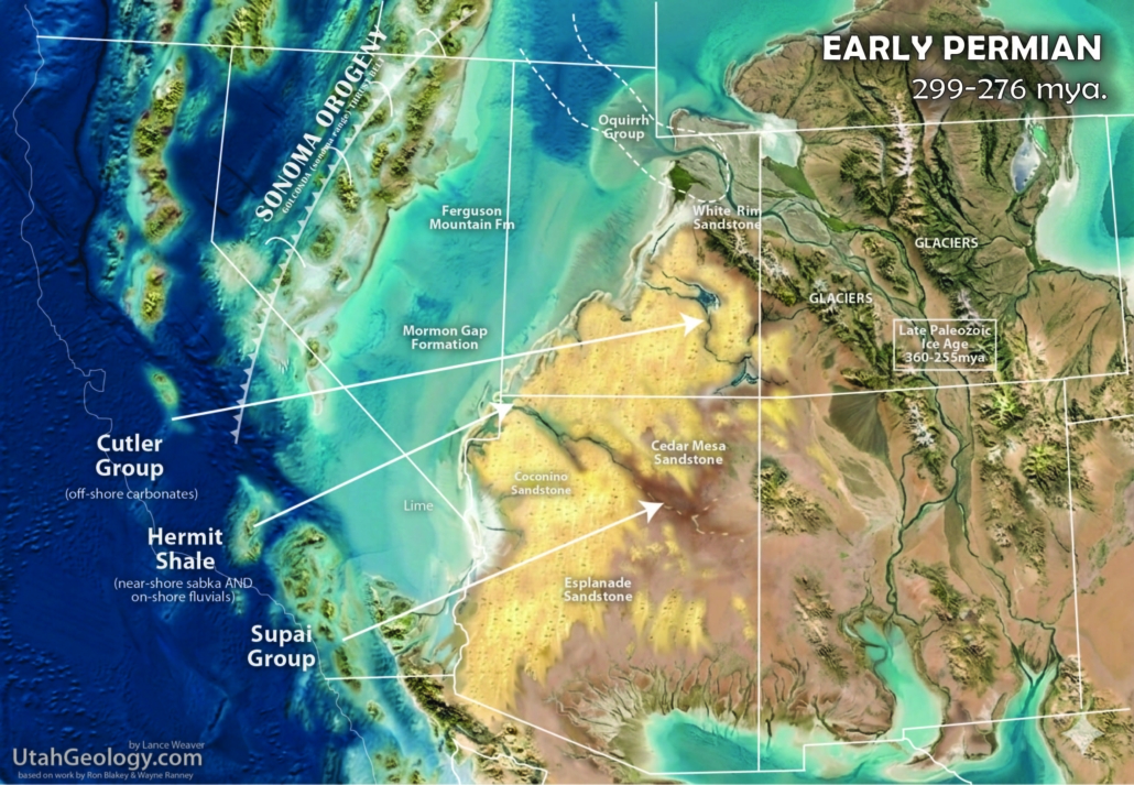
Early Permian Paleogeography
98 – 251 million years ago (mya)
The Early Permian (approximately 299 to 273 million years ago) in Utah, was dominated by the final pulses of the Ancestral Rocky Mountain orogeny and the waning stages of the Late Paleozoic Ice Age. Globally, the world was locked in a “icehouse” state, where fluctuating sea levels caused by Gondwanan glaciers drove dramatic cycles of marine transgression and regression. In the Grand Staircase and Southwest region, this is recorded by the Supai Group, particularly the Esplanade Sandstone, which represents a transition from marine-influenced coastal plains to the arid, terrestrial red beds of the Hermit Shale. To the east, the Paradox Basin reached its peak subsidence, acting as a massive structural “sump” that collected thousands of feet of sediment. While the Cutler Group (including the Cedar Mesa Sandstone) dominated the Four Corners, the Oquirrh Group to the north recorded a staggering ~20,000 feet of marine-heavy sediment in a rapidly deepening trough, illustrating the intense tectonic partitioning of the Utah crust during this era.
The Cedar Mesa Sandstone stands as a centerpiece of this landscape, representing a massive coastal erg (sand sea) and sabkha system. It interfingers with the marine-dominated Elephant Canyon Formation below and is capped by the fluvial and tidal deposits of the Organ Rock Shale. These sands weren’t just local; they were part of a continent-scale sediment conveyor. During the Early Permian, Pangaea was nearly fully assembled, forming a gargantuan landmass where terrestrial area was at its maximum. Interestingly, recent detrital zircon studies suggest that some of the quartz grains in these Western United States “sand seas” may have originated from the Appalachian-Hercynian highlands far to the east. With the continents fused, it is entirely possible that transcontinental river systems were transporting sediment from regions that are now part of Africa or Europe, crossing a vast, arid interior before being reworked by the wind into the towering white cliffs of the Cedar Mesa.
.
Pennsylvanian Paleogeography
323 – 298 million years ago (mya)
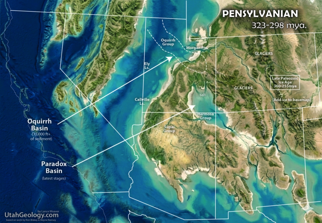
The Pennsylvanian period on the Colorado Plateau was defined by ocillating sea-leve driven by Late-Paleozoic ice ages, and the interplay of the rising Ancestral Rocky Mountains of Western Colorado, creating a deep, rapidly sinking basin that captured massive amounts of sediment. To the northwest, the Oquirrh Basin became one of the deepest subsiding troughs in North America, accumulating over 17,000 feet of marine sands and limestones in narrow subsiding bands. Simultaneously, the Paradox Basin formed as a restricted “deep hole” adjacent to the rising Uncompahgre Uplift. Because the basin was often cut off from the open ocean, it underwent cycles of extreme evaporation, depositing thick layers of salt and gypsum. When the “spigot” of the sea was turned on, these salts were covered by the marine limestones and black shales of the Hermosa Group, creating a striped stratigraphic record of a basin that was rhythmically breathing between open marine and a dead, salty sea.
While these deep basins were sinking, the surrounding shelf environments saw a complex dance between the sea and advancing terrestrial systems. The Supai Group represents this transition, where red-bed fluvial systems and coastal sand dunes prograded from the north and east, pushing against a fluctuating shoreline. During periods of low sea level, these river-driven sands and muds bypassed the highlands and dumped sediment into the shelves, while high sea levels saw the marine carbonates of the Hermosa Group and the Honaker Trail Formation retrograding back over the land. This interplay created a landscape of vast coastal deserts, seasonal river deltas, and shallow tropical carbonate banks, all occurring in the shadow of the jagged, rising Ancestral Rockies. By the end of the Pennsylvanian, the sheer volume of sediment being shed from these mountains began to overwhelm the basins, filling the the deep troughs and setting the stage for the massive sand seas of the Permian.
Huge changes in paleotectonics from earlier periods affected western North America. The Ancestral Rockies rose across the southern Western Interior. The Antler Mountains were already being worn down by erosion and even began subsiding in some areas. A marine basin covered most of western Utah and eastern Nevada.
.
Mississippian Paleogeography
358 – 323 million years ago (mya)
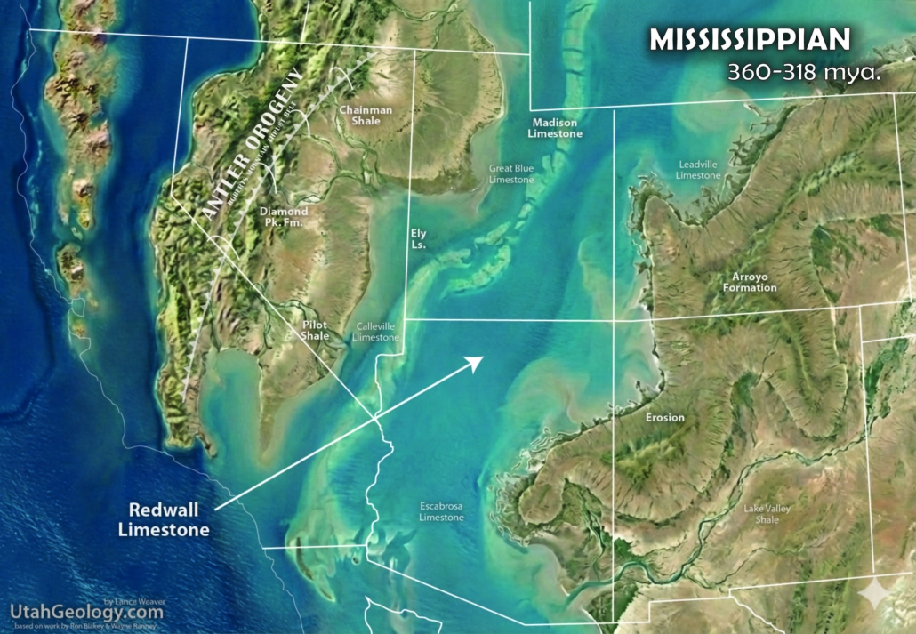
The Mississippian period (approximately 359 to 323 million years ago) in Utah was an era of colossal carbonate production and the first stirrings of major tectonic unrest. Across the Western Cordillera, the Antler Orogeny was in full swing; as an island arc collided with the western margin, it thrust oceanic rocks (the Roberts Mountains Allochthon) eastward into Nevada. This collision created a “foreland basin” effect in Utah: while the western part of the state began to trap flysch (the Chainman-Manning Canyon Shale), the rest of Utah remained a stable, sun-drenched carbonate platform. The defining unit of this time in the Grand Staircase and Southwest region is the Redwall Limestone, a massive, 500- to 800-foot-thick cliff-former teeming with crinoids, corals, and brachiopods. Toward the very end of the period, as the sea retreated, the land was carved by river channels and karst sinkholes, which were then filled by the Surprise Canyon Formation—a series of isolated, lens-shaped channel deposits that record the transition into the Pennsylvanian.
The Redwall Limestone is part of a continent-wide “carbonate bank” and correlates directly with the Deseret Limestone and the Humbug Formation in northern Utah, as well as the Leadville Limestone in Colorado. While the Redwall is primarily a pure, massive limestone, the Great Blue Limestone of the Oquirrh Basin in northern Utah represents a much thicker (up to 2,500 feet) and slightly younger pulse of this carbonate system, signaling the onset of massive subsidence in what would become the Oquirrh Basin. Interestingly, while the Antler Orogeny was active to the west, the Paradox Basin had not yet begun its massive Pennsylvanian-age collapse; however, the regional “stretching” from the Ancestral Rockies was just beginning to create the subtle structural troughs that would later define the region. Mississippian deposits in Utah range from a few hundred feet on the stable eastern shelves to a staggering 6,000 feet in the rapidly subsiding Oquirrh Basin, recording one of the most prolific episodes of marine limestone accumulation in Earth’s history.

.
Devonian Paleogeography
419 – 358 million years ago (mya)
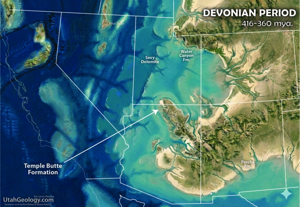
The Devonian Period (approximately 419 to 359 million years ago) in Utah was a time of “missing” time and dramatic sea-level fluctuations. In the Grand Staircase and Southwest regions, the Devonian record is notoriously sparse; it is absent across much of the Grand Canyon area, save for the Temple Butte Formation (often confused with the later Surprise Canyon channels), which exists only as isolated, purple-hued lenses filling paleovalleys carved into the underlying Cambrian rocks. This vast unconformity indicates that the region was a subaerial highland for millions of years. However, as you move north and east into the Uinta Mountains and the Wasatch Range, the record thickens significantly. Here, the Elbert Formation and the Ouray Limestone record a shallow, fluctuating sea. The most robust record is found in the Pilot Shale and the Guilmette Formation of Western and Northern Utah. The Guilmette, in particular, reaches staggering thicknesses of over 2,000 feet, consisting of massive carbonate platforms that indicate a rapidly subsiding shelf on the edge of the Panthalassic Ocean.
Tectonically, the Devonian saw the onset of the Antler Orogeny, the first major Paleozoic mountain-building event in the West, as an island arc began to collide with the continental margin. This created a deepening “trough” to the west while the interior remained a stable, albeit oscillating, shelf. The sea levels generally rose throughout the period, culminating in a greenhouse world that supported an explosion of life. These carbonates were mostly dolomitized, a result of restricted, magnesium-rich waters on the broad platforms. This was the “Age of Fishes,” where armored placoderms and early lobe-finned fish flourished in the reefs. On land, the first true forests were emerging; the earliest trees, like Archaeopteris, began to stabilize riverbanks and alter global carbon cycles. While Utah’s southwest remained high and dry, the northern and western basins were teeming with life and sediment, recording a world transitioning from a quiet coastal margin into a tectonically active frontier.
.
Silurian Paleogeography
443 – 419 million years ago (mya)
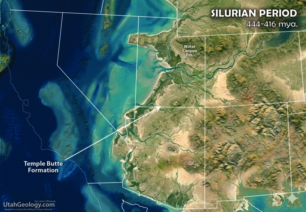
The Ordovician & Silurian periods represent a mysterious “missing chapter” in the geology of the Grand Staircase and Southern Utah. In the Grand Canyon and the Mogollon Rim, there are no Silurian rocks whatsoever; the Mississippian Redwall or Devonian Temple Butte formations rest directly upon Cambrian strata. This massive ‘Little Unconformity‘ (as opposed to the ‘Great Unconformity’ was not caused by a lack of deposition, but rather by a combination of a relatively high-standing continental interior and subsequent pulses of erosion. During the Silurian, the Southwest was likely a broad, low-relief upland or a very shallow, non-depositional shelf. In contrast, Northern Utah and Southeast Idaho sat at the edge of the true Cordilleran miogeocline. Here, the crust subsided steadily, allowing for the accumulation of the Laketown Dolomite, a massive, dark-gray carbonate unit that reaches thicknesses of over 1,000 feet. This thick sequence of dolomite indicates a stable, warm, and shallow marine environment far removed from the erosional highlands to the south.
Tectonically, the Western Cordillera was remarkably quiet compared to the violent collisions occurring on the eastern coast of North America (the Acadian Orogeny). The western margin was a passive “Atlantic-style” coast where the continental shelf edge ran roughly through central Nevada. Sea levels were globally high following the melting of the Late Ordovician glaciers, creating sprawling epicontinental seas. In these clear, shallow waters, life was undergoing a silent revolution; the Laketown Dolomite and its equivalents, such as the Fish Haven Dolomite (technically Upper Ordovician but often grouped in sequence), are filled with “chain corals” (Halysites) and “honeycomb corals” (Favosites). While the first vascular plants began to creep across damp coastal muds and jawed fish started to diversify in the oceans, the Southwest remained a silent, bypassed landscape. It was only during later Paleozoic and Mesozoic uplifts that any thin Silurian veneers that might have existed in Southern Utah were stripped away, leaving the yawning temporal gap we see today.
.
Ordovician Paleogeography
485 – 443 million years ago (mya)
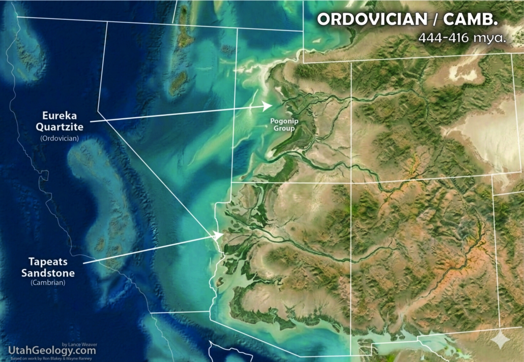
Note the continuation of Cambrian depositional and tectonic patterns. The western view show a rapidly approaching oceanic arc. As the ocean off western North America subducts below the arc, the arc closes in on the North American coast. The area of origin of this arc is unknown but highly debated — some geologist derive it from far across the Paleo-Pacific and others argue for an origin not far off North America.
.
Cambrian Paleogeography
541 – 485 million years ago (mya)
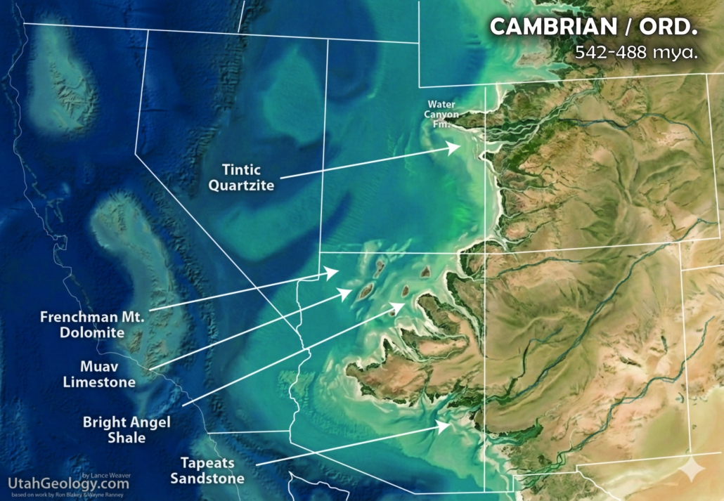
The Cambrian Period (approximately 539 to 485 million years ago) represents the foundational “breakout” of the Phanerozoic Eon in the American West. In the Grand Staircase and Grand Canyon regions, the Cambrian sequence is dominated by the Tonto Group, a classic transgressive trilogy consisting of the Tapeats Sandstone, Bright Angel Shale, and Muav Limestone. These units account for nearly half of the total Paleozoic rock volume in the Grand Canyon, representing a sea that slowly marched eastward across a barren, weathered Precambrian basement. As the shelf deepened toward the west, the sequence thickened significantly; a key example is the Frenchman Mountain Dolostone near Las Vegas, which is often distinguished from the Muav due to its increased thickness and unique crystalline structure, marking the transition into the deeper Cordilleran miogeocline. To the north, in the Wasatch and Uinta Mountains, the stratigraphy becomes even more complex with units like the Tintic Quartzite and Lodore Formation. These are often dominated by arkosic sands—sandstones containing at least 25% feldspar—which suggests the rapid erosion of granitic highlands. These mineral-rich sediments were likely the “scour” left behind by the catastrophic “Snowball Earth” glaciations that ended just before the Cambrian, leaving a continent stripped bare and ready for burial.
The proliferation of so many distinct Cambrian layers was driven by an exceptionally “unstable” global sea level and the fragmentation of the supercontinent Rodinia. As the continental crust stretched and subsided, the shoreline oscillated wildly, creating a mosaic of environments that fueled the Cambrian Explosion. This period saw an unprecedented “explosion” of biological genera, from the ubiquitous trilobites to the bizarre Anomalocaris. This biological chaos was underpinned by a massive shift in geochemistry: atmospheric oxygen levels were rising steadily toward a “tipping point” that allowed for the development of complex, energy-demanding metabolic systems and hard skeletal parts. The staggering number of layers in Utah—such as the Ophir Shale, Wheeler Shale (famed for its fossils), and Marjum Formation—records a world where the atmosphere and oceans were finally becoming hospitable to complex life such as that seen in the Burges Shale to the north.
PreCambrian Paleogeography
1500 – 485 million years ago (mya)
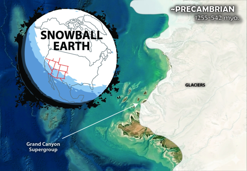
The Precambrian Eon in Utah, the Grand Canyon and the Western Cordillera represents the foundational “deep time” of the continent, covering a huge chunk of Earth’s history. At the very base Precambrian rock record lies the Vishnu Schist and its equivalents, a “basement” of intensely metamorphosed and mineralized rocks formed during the collision of island arcs with the proto-North American craton (Laurentia) nearly 1.7 billion years ago. These crystalline rocks, visible in the inner gorge of the Grand Canyon, the Black Canyon of the Gunnison, and the core of the Uinta Mountains, represent the roots of ancient mountains & deformation episoded planed down by the glaciers of ‘snowball earth‘. Resting atop this basement is the tilted and fragmented Grand Canyon Supergroup, a staggering 9-12,000-foot-thick sequence of angled sedimentary layers. These strata, such as the Hakatai Shale, feature vibrant redbeds—a color palette that would not dominate the region again until the Permian Hermit Shale. This period was characterized by the “Snowball Earth” glaciations, where global ice sheets acted as colossal sandpaper, scouring the crust and depositing massive volumes of arkosic sediment (large grained granitic erosional debris) that would eventually be reworked into the base of the Cambrian and later sediments.
The defining feature of this era is the Great Unconformity, a world-wide gap in the rock record where up to a billion years of history was erased by erosion before the Cambrian seas advanced. During this vast interval, Earth’s atmosphere was undergoing a radical shift; the rise of photosynthetic bacteria began to pump oxygen into the oceans, triggering the precipitation of Banded Iron Formations (BIFs) as dissolved iron oxidized and settled onto the seafloor. While Utah’s Precambrian redbeds are rich in hematite, they are not the direct source of the iron that colors the later Mesozoic “Red Rock Country,” the intense staining of formations like the Wingate or Navajo which resulted from the later breakdown of iron-bearing silicate minerals may have gotten some of their altered iron from these reworked and eroded deposits. This Precambrian foundation—thick with arkosic sediments, mineralized, warped, and deeply eroded—provided the rigid structural “stage” and building materials upon which all subsequent Paleozoic marine transgressions and Mesozoic sedimentation would perform.
.
.
To Do:
-add a linked table of contents
-add a section on radical theories
-expanding earth (from mantel density flux) as a driving mechanism for plate tectonics, Earth as a rocky gas giant, gradual and catastrophic TPW as driver of orogenesis.
-add a planetary geology section
-add sections for every geologic age. Cover each major formation/group within those sections
–
Leave a Reply
Want to join the discussion?Feel free to contribute!