
Hermit/Organ Rock (Geology of The Grand Canyon)
Explore unit thickness in All-in-One App
Age: Early Permian (Cisuralian); approximately 285 to 275 million years ago (Ma).

Exposure: Easily identified as the wide, brick-red slope below the Coconino Sandstone. Best seen along the Bright Angel Trail at the “Hermit Basin” or from the Desert View Watchtower. It is also well-exposed in the Hurricane Cliffs of Southern Utah.
Age: Early Permian (Cisuralian); approximately 285 to 275 million years ago (Ma).
Lateral Equivalents: Organ Rock Fm of Cutler Group (Southeast UT); Abo Formation (NM); Maroon Formation (CO); Queantoweap Sandstone (Western Grand Canyon/NV); Wells Formation (ID). SADONA’s Schnelby Hill Formation, sits between the Hermit & Coconino ss.
Depositional Environment: Semi-arid coastal plain and river floodplains. The environment featured meandering streams, sluggish deltas, and expansive mudflats. Frequent subaerial exposure is evidenced by mud cracks, ripple marks, and the preservation of terrestrial plant fossils in fine-grained silt.
Paleogeography: Located on the western edge of the supercontinent Pangea. The region was situated at approximately 10° North latitude, effectively placing the Southwest in a tropical to subtropical belt near the paleo-equator, bordered by a shallow sea to the west.
Tectonics: Deposited during the Ancestral Rocky Mountain orogeny. While the plateau remained a stable block, the nearby uplifting mountains (like the Uncompahgre Uplift) provided the sediment. It preceded the more intense Sonoman Orogeny that would eventually affect the western Cordilleran margin.
Climate: Semi-arid and monsoonal. High temperatures and seasonal rainfall led to periodic flooding and long periods of drying. The high evaporation rates and atmospheric exposure of sediments allowed iron minerals to oxidize, giving the formation its characteristic deep red color.
Features: Notable for its slope-forming morphology and vivid crimson color. It contains remarkably preserved primary structures like mud cracks, raindrop impressions, and ripple marks. In some locations, the unit fills deep paleochannels cut into the underlying rocks.
Fossils: Renowned for its Permian flora, including seed ferns like Supaiia and Walchia (conifers). It also contains vertebrate trackways of early tetrapods (primitive reptiles and amphibians) and rare insect wings, providing a crucial record of Early Permian terrestrial life.


Description:
The Hermit Formation (traditionally called the Hermit Shale) is one of the most visually striking units of the Grand Canyon, manifesting as a deep-red, recessive slope situated directly beneath the vertical cliffs of the Coconino Sandstone. This formation represents a significant transition in the Permian geologic record, moving away from the marine-dominated carbonate systems of the earlier Paleozoic toward a terrestrial, siliciclastic environment. The unit is primarily composed of siltstone, mudstone, and fine-grained sandstone, all heavily pigmented by hematite (iron oxide). This oxidation occurred as sediment was exposed to the atmosphere in a subaerial setting, creating the “red beds” that define the middle elevations of the canyon walls. In the Grand Canyon, the Hermit sits upon an erosional unconformity, having been deposited into broad, shallow valleys carved into the underlying Supai Group.
Depositionally, the Hermit Formation formed within a vast prograding coastal plain and river delta system. During the Early Permian (approx. 280 Ma), sluggish, meandering rivers flowed southwestward across the stable craton toward the sea. These river systems deposited fine-grained silts and clays across wide floodplains, while occasional flash floods spread sand across the landscape. The environment was periodically desiccated, leading to the formation of mud cracks and the preservation of delicate rain-drop impressions. A modern analog for this setting can be found in the Fly River Delta of Papua New Guinea or the Burdekin River in Australia, where broad, low-gradient coastal plains are subject to seasonal wetting and drying, resulting in extensive fine-grained sediment accumulation.
In the broader Cordilleran tectonic context, the Hermit Formation was deposited during the assembly of the supercontinent Pangea. While the Colorado Plateau remained a relatively stable platform, the collision of Gondwana with Laurasia to the east was creating the Ancestral Rocky Mountains. These nearby uplifts provided the source material for the Hermit’s sediments. To the west, the subduction zone along the continental margin was beginning to influence the regional stress field, though the plateau itself experienced mostly gentle subsidence rather than intense deformation. Regionally, the Hermit is time-equivalent to several significant units: it correlates with the lower portions of the Cutler Group (specifically the Halgaito and Cedar Mesa formations) in San Juan County, Utah, the Abo Formation in New Mexico, and parts of the Maroon Formation in Colorado and the Wells Formation in Idaho.
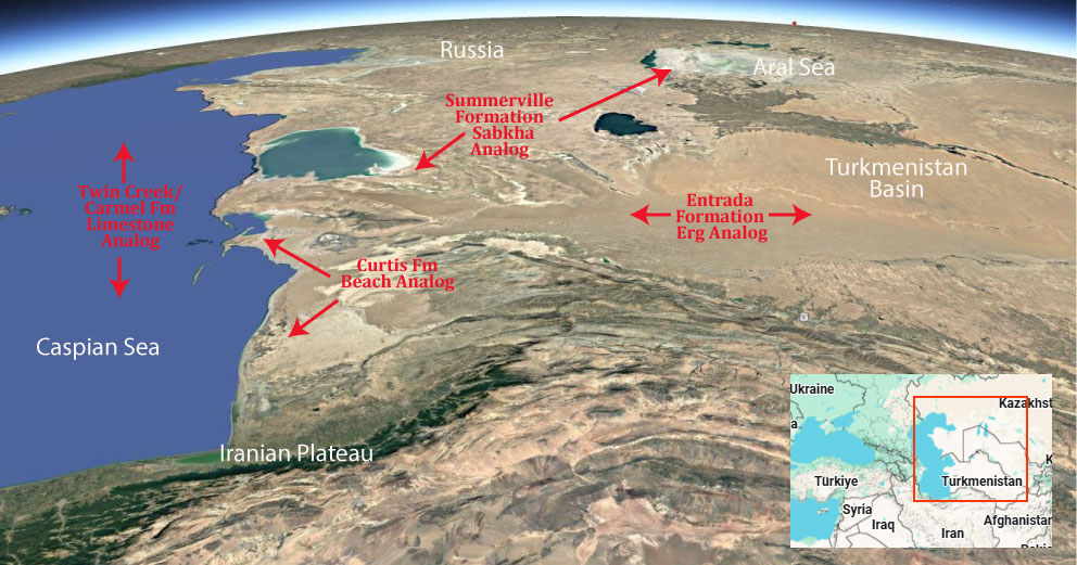
Modern Analog to Utah’s Middle Jurassic
.
Paleogeography or Depiction of Utah during Middle Jurassic

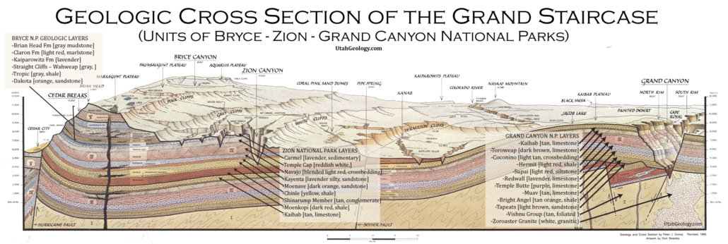
What is the Grand Staircase?
The Grand Staircase is a unique and extensive exposure of Earth’s history, showcasing over 200 million years of sedimentary rock layers. Geologists often liken these layers to a “book,” allowing for a detailed study of the Earth’s past, including changes in climate and environment.
The major sedimentary rock units exposed in the Grand Canyon range in age from 200 million to 600 million years and were deposited in warm shallow seas and near-shore environments. The nearly 40 identified rock layers of Grand Canyon form one of the most studied geologic columns in the world.

[flickr_tags user_id=”95435349@N04″ randomize=”true” margins=”4″ pagination=”numbers” tags=”navajo” max_num_photos=”9″]
[flickr_tags user_id=”95435349@N04″ tags=”chinle, navajo”]