
Supai & Hermosa Group / Weber Sandstone (Geology of The Grand Staircase)
Explore unit thickness in All-in-One App

Exposure:
The Supai Group is seen throughout the Grand Canyon. Moving northward it transitions into the Hermosa Group and can be Seen in the Goosenecks area and especially in Canyonlands. Farther north, the time equivalent Weber Sandstone of the Vernal area is particularly notable.
Age: Early Permian, 315-285 million years ago.
Depositional Environment: deposited in a nearshore eolian, or wind-blown, environment. Specifically, it formed along the western edge of the ancient Pangaean Supercontinent. The Hermit Shale, which sits above the Esplanade, was deposited in a fluvial and coastal plain environment. The Esplanade Sandstone is part of the Supai Group, which generally represents a diverse range of environments, but eolian sands are most prevalent.
Paleogeography: Like most Grand Canyon units, the region was likely the western coast of the North American craton during much of the Paleozoic.
Tectonics: The collision of the Gondwana Plate with the North American Plate resulted in the Uncompahgre highland and thick deposits of the Paradox Basin of this age.
Climate: probably dry, but also likely prone to wide temperature swings associated with Karoo Glaciation of South Africa, Antarctica & South America (Gondwana).
Features: The Supai Group in the Grand Canyon is notable for its interbedded reddish shales, buff or pinkish buff sandstones, and gray limestones. It forms a prominent red staircase on the canyon walls, below the Hermit Shale and above the Redwall Limestone. The Supai Group also contains fossils, including fern-like leaves, reptile tracks, and various marine life.
Prominent Cliffs and Stepping Stones: The resistant sandstones within the Supai Group have eroded into thick, massive beds that form prominent, vertical cliffs. The overall effect of the interbedded rocks is a series of red staircases descending from the higher layers.
Fossils: Fossils are found in these layers, including fern-like leaves, reptile tracks, and various marine fossils like brachiopods, trilobites, seaweed, and sponges.
Geological Context:
.
The Supai Group was deposited in a variety of environments, including coastal lowlands, arid coasts, and rivers/swamps.


Description:
The Supai Group consists of alternatingly interbedded soft, reddish shales and sandy; hard, buff or pinkish buff sandstones; and, in its lower part, hard, gray limestones. Most the sandstone consist of thick, massive beds that erode as prominent, vertical cliffs. The limestones also erode to form erode as prominent, vertical cliffs. The beds of shale and laminated sandstone weather as slopes. The alternation of hard and soft beds form a distinct step-like profile, which consists of alternating cliffs and slopes. The Supai Group overlies either the Redwall Limestone or Surprise canyon Formation and underlies the Hermit Formation.
This topographic profile of the Supai Group is consistent enough that it was initially divided into five subdivisions based upon the cliff versus its slope-forming character and, thus, indirectly on associated lithology within the Grand Canyon region. They are the (1.) Upper cliff unit, locally includes a receding ledge unit (Esplanade cliff); (2.) Upper slope unit; (3.) Middle cliff unit; (4.) Middle slope unit; (5.) Lower cliff and slope unit. These units can be traced throughout the Grand Canyon as they differ remarkably little from one end to the other. However, westward, the slope units do become less conspicuous. In particular, the middle slope unit becomes so weakly developed in the western Grand Cayon region, that the lower and middle cliff units seem to merge together such that lower and middle cliff units appear to merge together.
In 1975, McKee incorporated specific key beds, fauna zones, and erosion surfaces into the above topographic units to define the Watahomigi formation, Manakacha formation, Wescogame Formations and Esplanade Sandstone. Most important to defining and mapping these formations are three key beds, in addition to the basal conglomerate underlying the Redwall Limestone and Surprise canyon Formation, consisting of widespread, lithologically distinct, conglomerates. Two of these of conglomerates are associated with marked erosional surfaces and, thus, likely represent regional unconformities. Marine fossils that occur above and below. these conglomerates also indicate that represent significant periods of nondeposition and erosion.
The deposits of the Supai Group accumulated during multiple transgressive-regressive cycles associted with major sea level fluctuations reflecting changes in the volume of continetal ice sheets resulting from glacial – interglacial cycles. As a result of significant chnages in eustatic sea level locally modulated by local subsidence or uplift. As sea level fluctulated, fluvial, eolian, tidal, and shallow marine environments associated with a broad coastal plain shifted back and forth across the Grand Canyon area resulting in the cyclic deposition red beds, eolian sandstones, and marine limestones. Limestone beds represent the shallow marine limestone deposited during highstands of sea levels during maximum transgression. Unconformities characterized by paleovalleys and erosion surfaces covered with conglomerates represent lowstands of sea level during which river eroded deeply into coastal plains. The cyclic deposition of these sediments began with latest Mississippian and continued through the Pennsylvanian
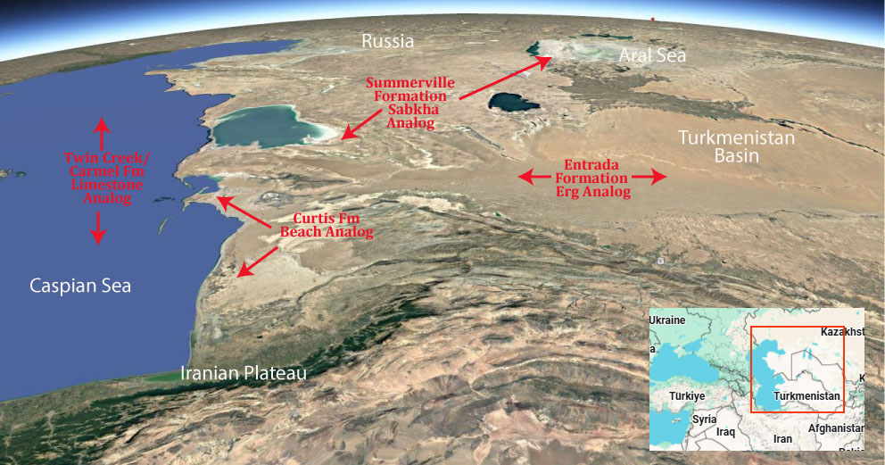
Modern Analog to Utah’s Middle Jurassic
.
Paleogeography or Depiction of Utah during Middle Jurassic

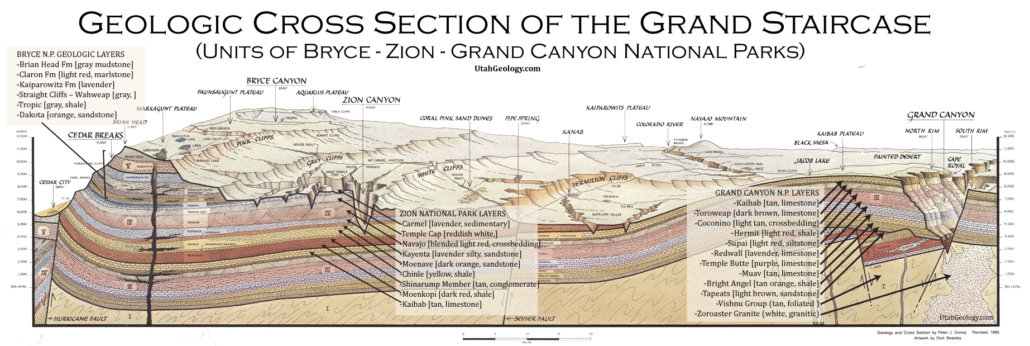
What is the Grand Staircase?
The Grand Staircase is a unique and extensive exposure of Earth’s history, showcasing over 200 million years of sedimentary rock layers. Geologists often liken these layers to a “book,” allowing for a detailed study of the Earth’s past, including changes in climate and environment.
The major sedimentary rock units exposed in the Grand Canyon range in age from 200 million to 600 million years and were deposited in warm shallow seas and near-shore environments. The nearly 40 identified rock layers of Grand Canyon form one of the most studied geologic columns in the world.

[flickr_tags user_id=”95435349@N04″ randomize=”true” margins=”4″ pagination=”numbers” tags=”navajo” max_num_photos=”9″]
[flickr_tags user_id=”95435349@N04″ tags=”chinle, navajo”]