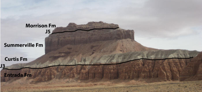
Curtis Formation (Geology of Utah’s Grand Staircase)
Explore unit thickness in All-in-One App

Exposure:
Within the Grand Staircase, the Curtis Formation is best exposed in east of Capital Reef National Park just south of Goblin Valley State Park.
Age: Deposited from early to late Oxfordian time (161 – 155 Ma) (Wilcox, 2007).
Depositional Environment:
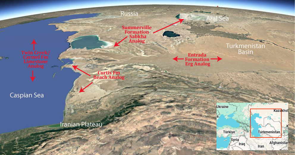
Marine and marginal-marine tidal flat. Comprises one unconformably-bound, transgressive-regressive (T-R) sequence (Wilcox, 2007).
Paleogeography:
A major transgression of the Late Jurassic seaway drowned the eolian sand sea of the Entrada Formation. Subsequent regressive paleoflow was to the northeast into the Late Jurassic interior seaway (Kocurek & Dott, 1983).
Tectonics:
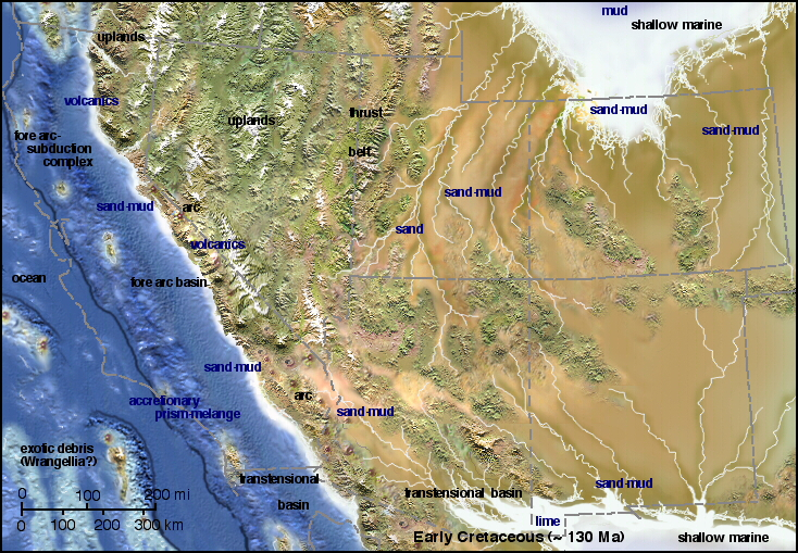
Deposition was in a retroarc to craton-margin basin as the region drifted north (Kocurek & Dott, 1983).
Climate:
With paleolatitude range of 5 to 25 degrees north, the paleoclimate was both hot and arid (Kocurek & Dott, 1983).
Features:
The Curtis Formation shows a variety of nearshore sedimentary structures (e.g. horizontal bedding -> beach, rhythmites and sigmoidal bundles -> tidal). The Jurassic “J3” unconformity, a regional surface of erosion atop the Entrada Formation, marks the basal bounding surface of the Curtis-Summerville T-R sequence. A thin, lower Curtis transgressive systems tract is the finest grained facies of the Curtis Formation topped by a maximum flooding surface. Thick middle and upper Curtis deposits represent a highstand systems tract reflected in upward coarsening cycles from marine shelf to tidal channels to shoreface envirionments. The upper sequence is tidal flat, reddish-brown mudstones and evaporites of the Summerville Formation topped by the “J5” unconformity, the upper sequence bounding surface and the contact with overlying Morrison Formation (Wilcox, 2007).
Description:
The Curtis Formation is composed of shallow marine sandstone, with thin beds of mudstone and minor limestone and gypsum. The sandstone is grayish-green in color and flat bedded or cross bedded. The presence of glauconite and marine invertebrate fossils indicates it was laid down in a shallow marine environment that became hypersaline towards the end of deposition. It represents a high stand of the Sundance Sea in the Callovian
The formation was first described by Gilluly and Reeside in 1928 and named for exposures in the northeast San Rafael Reef at Curtis Point (39.126665°N 110.447615°W). Pipiringos and Imlay reassigned the Curtis as a member of the Stump Formation in 1979,[2] but this was rejected by Peterson in 1988.
Modern Analog to Utah’s Middle Jurassic
.
Paleogeography or Depiction of Utah during Middle Jurassic
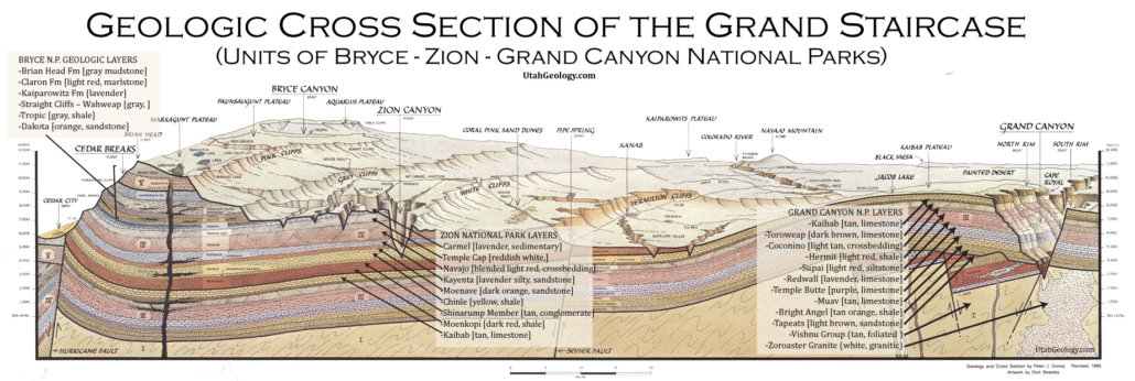
What is the Grand Staircase?
The Grand Staircase is a unique and extensive exposure of Earth’s history, showcasing over 200 million years of sedimentary rock layers. Geologists often liken these layers to a “book,” allowing for a detailed study of the Earth’s past, including changes in climate and environment.
The major sedimentary rock units exposed in the Grand Canyon range in age from 200 million to 600 million years and were deposited in warm shallow seas and near-shore environments. The nearly 40 identified rock layers of Grand Canyon form one of the most studied geologic columns in the world.

[flickr_tags user_id=”95435349@N04″ randomize=”true” margins=”4″ pagination=”numbers” tags=”navajo” max_num_photos=”9″]
[flickr_tags user_id=”95435349@N04″ tags=”chinle, navajo”]