Nestled within the Glen Canyon National Recreation Area (GCNRA), Lake Powell is a testament to both human ingenuity and the enduring power of nature. The lake fills the entirety of the 170 mile length of Glen Canyon. Sometimes referred to as Utah’s “sixth national park,” this vast reservoir offers a unique blend of recreation and stunning geological beauty. Its sheer size and intricate shoreline distinguish it from any of Utah’s other lakes, while its geological story reveals a complex and fascinating past.
Houseboats parked in Navajo Canyon, amidst towering cliffs of Navajo Sandstone.
The first recorded European encounter with Glen Canyon comes from the Domínguez-Escalante Expedition of 1776. Just a few months after Thomas Jefferson signed the Declaration of Independence, the two Spanish explorers spent several weeks being led by Native American guides across a narrow passage through the canyon’s nearly impenetrable walls. Almost one hundred years later in 1869, John Wesley Powell, the lake’s namesake, explored the area by boating down the Colorado River and wrote the first known geologic investigation of the region. Almost another century later, in 1956, construction began for Glen Canyon Dam near the Utah-Arizona border. Designed to regulate and store water from the Colorado River Basin for six states—Utah, Colorado, Arizona, New Mexico, Nevada, and California—the dam also became a vital source of hydroelectric power. Its construction followed years of debate among government agencies, conservationists, and water resource planners, underscoring its enduring role in regional water management and the ongoing discussions surrounding its impact. The completion of the dam led to the formation of Lake Powell, one of the largest reservoirs in the United States.
Simplified stratigraphic column.
Perhaps Lake Powell’s most unique feature is its expansive cliff-lined shores. At full pool, its shoreline stretches greater than 1,900 miles, a figure that dwarfs the entire west coast of the continental United States. This remarkable length is a product of the flooding of Glen Canyon’s intricate network of slot canyons and translates to a myriad of opportunities for exploration in the 96 major canyons and countless smaller coves and inlets. Adding to its allure are the numerous natural features found within the recreation area, most notably iconic natural bridges and arches like Rainbow Bridge, Coyote Natural Bridge, Halls Creek Bridge, Broken Bow Arch, LaGorce Arch Dand many more in Glen Canyon’s Escalante arm. These natural wonders, sculpted by millennia of erosion, punctuate the landscape and provide a glimpse into the canyon’s ancient geological history. The geology of Glen Canyon is a story spanning hundreds of millions of years. It represents a continuous sequence of rock layers, ranging from Early Permian (~295 million years old) to Late Cretaceous (~75 million years old). The oldest exposed rock layer, the Permian-age Cutler Group, lies at the base of this geological sequence and is exposed on the flanks of the Monument Upwarp on the northeast end of the lake. Above the Cutler lies the Late Permian-age (~270 million years old) Kaibab Formation and the Early Triassic-age (~250 million years old) Moenkopi Formation, which is visible on both the northernmost and southernmost areas of Glen Canyon National Recreation Area. Overlying the Moenkopi is the Middle to Late Triassic-age (~230 million years old) Chinle Formation, known for its vibrant colors and abundant petrified wood.
Perhaps the most impressive geologic unit in the region is the Early Jurassic-age (~200 to 190 million years old) Glen Canyon Group, a suite of sandstones that dominate the canyon’s landscape and borrows its name. This group consists of the Wingate Sandstone, known for its deep red sheer cliffs; the Kayenta Formation, characterized by its ledges and slopes of interbedded shale and sandstone; and the massive Navajo Sandstone, which forms large cliffs and slickrock canyons. This sequence of sandstones tells a story of ancient deserts with shifting sand dunes in a setting not unlike that of the modern Sahara Desert (see Survey Notes v. 44, no. 3). The entirety of the southern Utah Cretaceous sequence (~145 to 66 million years ago) is also visible from the southern and central parts of the lake, offering a complete picture of the region’s Mesozoic Era history.
The impressive collection of canyons that compose Glen Canyon National Recreation Area were carved by the Colorado River and its tributaries long after the deposition and lithification of rock layers on the Colorado Plateau. The age of uplift and erosion that created the canyons, as well as the Grand Canyon, is a subject of ongoing debate. While the prevailing view suggests that the majority of the modern Glen Canyon’s erosion occurred within the last five million years, evidence of earlier erosional activity exists. Small streams cutting through the tightly folded strata of the Waterpocket Fold and East Kaibab Monocline hint at river systems in the area dating back at least to the Laramide mountain-building event some 70 to 40 million years ago.
Broken Bow Arch, Escalante Canyons section of Glen Canyon National Recreation Area.
Part of what makes the geology of Lake Powell so unique is the juxtaposition of the lake’s completely level surface against the undulating regional geology. As one travels up lake from the dam, geologic rock formations separated by thousands of feet and millions of years take turns occupying the shorelines. This unique experience is caused by the regional folding of the Monument and Circle Cliffs Upwarps that have uplifted the lowest (oldest) layers to the surface in the northmost sections of the lake, exposing the Permian- and Triassic-age units. Conversely, downwarps like the Kaiparowits Basin, bring younger Cretaceous- and Late Jurassic-age layers to lake level. Adding to the geological intrigue are smaller geologic features visible from the lake, called laccoliths, caused by rising magma which bent the overlying rocks into unique dome-like structures seen at Navajo Mountain, Mount Ellsworth, and Mount Holmes.
Lake Powell stands as a significant testament to the interwoven forces of nature and human activity. It offers visitors a unique way to traverse Glen Canyon and explore its diverse topography and geology. The creation of this vast, and sometimes controversial, reservoir has transformed a once-wild, actively erosive landscape into a more tranquil blend of recreation and utility, offering visitors unparalleled access to breathtaking landscapes unique to those available up and downstream on the Colorado River.
https://utahgeology.com/wp-content/uploads/2026/02/image-4.png8831280Lance Weaverhttps://utahgeology.com/wp-content/uploads/2025/07/utah-geology-site-logo-420px-new.pngLance Weaver2026-02-15 19:11:052026-02-17 16:23:35A Geologic Overview of Lake Powell, Utah
Hidden in a remote corner of Washington County is a fascinating place nearly forgotten among the other attractions of southern Utah. The scenic Pine Park area exposes intriguing volcanic deposits that reveal the story of the largest volcanic eruptions in Utah’s geologic history. Although the beautiful exposures outcrop in only a small area, the eruptions that produced the volcanic deposits in this part of Utah were some of the largest in Earth’s history.
Exposures of the Tuff of Honeycomb Rock at Pine Park.
Pine Park is located approximately 20 miles (32km) southwest of Enterprise in the southwest corner of Utah. It is one of several attractions located on the upper Beaver Dam Wash. The region supports a high desert forest of juniper, pinyon, and large ponderosa pine trees, which thrive in the well-drained volcanic soils. The main attractions in Pine Park are bright white volcanic ash-flow tuff exposures that form a landscape of hoodoos, pyramid- and mushroom-shaped domes, and undulating slickrock basins. Many of these vistas resemble the hoodoos and knobs of the better-known Goblin Valley State Park of central Utah, or the Toadstools area near Lake Powell’s Wahweap Bay. However, instead of the familiar sandstone and claystone of Utah’s Colorado Plateau, these spires have eroded from thick deposits of white volcanic ash-flow tuff known as the Tuff of Honeycomb Rock. An ash-flow tuff is a type of rock made of volcanic ash, rock, and gases derived from explosive volcanic eruptions.
A few miles to the west down Pine Park Canyon, at Beaver Dam State Park in Nevada, the same types of ashflow tuff deposits create scenic vistas like those of Pine Park. These two attractions showcase just a small piece of the voluminous ash-flow tuff deposits that blanket the region. Called “supervolcanoes” or “super-eruptions” because of their immense size, these types of eruptions tend to leave behind massive, often miles-wide, craters called calderas instead of the typical pyramid-shaped cones of stratovolcanoes. A caldera’s large, cauldron-like hollow or valley forms after magma erupts and the ground surface above the magma chamber collapses.
Miocene- to Oligocene-age (12 to 36 million years ago) supervolcanoes, caldera complexes, and volcanic deposits, which stretch from south-central and western Utah through Nevada and eastern California. From Best and others, 2013, Geosphere article: https://doi.org/10.1130/GES00945.1
Pine Park lies at the edge of the ancient Pine Park caldera—one of dozens of calderas spanning from southwestern Utah, across central Nevada, to the border of eastern California. These supervolcanoes were active between 12 and 36 million years ago, when Utah was home to rhinoceros, camels, tortoises, and palm trees. Although the Tuff of Honeycomb Rock that outcrops at Pine Park is locally derived from a smaller ancient caldera, many of the ash-flow tuffs in the area are derived from the nearby Indian Peak–Caliente caldera complex, formed by some of the largest ancient super-eruptions in North America. Geologists have found deposits 2.5 miles (4 km) thick that are believed to have come from a single incredible eruption from the Indian Peak–Caliente caldera complex 30 million years ago. Over 1,300 cubic miles (5,400 km3) of volcanic materials have been found from this eruption spanning from central Utah to central Nevada and from Fillmore, Utah, on the north to Cedar City, Utah, on the south—over 1,000 times the volume of material ejected during the 1980 Mount St. Helens eruption (about 1 cubic mile [4 km3]). And this caldera was only one of up to 20 calderas in the region.
Since the eruption of the volcanoes that created the deposits of Pine Park, extension of the Earth’s crust across the Basin and Range Province has torn apart much of western Utah and has vastly altered the landscape and drainages. Without geologists studying the thick volcanic deposits such as those exposed at Pine Park, people may have never known the extent to which ancient volcanoes altered the landscape of this part of southern Utah.
https://utahgeology.com/wp-content/uploads/2026/02/image-1.png9471200Lance Weaverhttps://utahgeology.com/wp-content/uploads/2025/07/utah-geology-site-logo-420px-new.pngLance Weaver2026-02-15 19:04:582026-02-16 02:27:27Pine Park and the Ancient Supervolcanoes of Southwestern Utah
Rise of the Colorado Plateau (33-15 MYA), and Formation of the Colorado River & Grand Canyon
The Eocene lakes PROVE the timing of the drainage reversal!
Introduction
For over two decades, the geologic community has remained locked in a debate regarding the “Old” versus “Young” Colorado River. In this article I’d like to show how almost all researchers have missed the most obvious and important detail needed to solve this puzzle—which is seeing Utah & Wyoming’s well-known early Cenozoic lakes as the primary evidence of drainage reversal. Unfortunately, almost all modern researchers have overlooked this obvious evidence and instead, hyper-focused on more speculative regional datasets, such as the geochemical signatures of the Grand Wash Trough, the Peach Springs Tuff, a speculative Lake Bidahochi or the elusive zircon dating of downstream alluvium—which only help us infer when the Colorado River found its modern course. I argue that such approaches are like missing the forest for the trees, overlooking the most important evidence for the south-flowing Colorado River’s formation, which has been staring everyone the face—Lake Uintah, Lake Goshute and other early Cenozoic mega-lakes as syn-orogenic signals for drainage reversal and fill-to-spill reorientation of Colorado Platea drainages. To understand the Colorado River’s evolution, we must prioritize these two vital diagnostic features: the Paleocene & Eocene lacustrine (lake) “fill-to-spill” deposits as the only real evidence for widespread Colorado Plateau drainage reversals (59-45mya) and the timing of river incision through the many massive Late Laramide structural folds (45-34mya) which had to form after the river had largely established its current course on the Plateau. Rapid incision and establishment of the modern course downstream of the Grand Wash Fault came much later in the early to mid-Pliocene.
Addressing the former first, its important to remember that in all locations which completely lack ANY evidence of large basin fill deposits suggesting a fill-to-spill scenario of fold overtopping– the fold had to pre-date or “antecede” the upwarps of the Colorado Plateau in order to maintain eroding a coarse & canyon through these massive folds as they formed. Let me repeat that. A river HAD TO PREDATE most the major Laramide folds which the modern rivers currently cut through. There is simply no way around it. (Pun intended!). The Colorado River cuts through the Kaibab, Monument, Circle Cliffs, Uinta/Split Mountain, and Uncompahgre uplifts, and its tributaries cut through the Cockscomb, VRG, San Rafael swell and other upwards, with ZERO evidence of basin fill deposits behind the fold in most cases. This strongly suggesting these watercourses were established BEFORE the canyon incision through these upwarps began in the middle to late Cenozoic (mostly 14-0 mya).
Since the rise of many of these folds date from BEFORE the Colorado River was established in it’s current coarse, we can safety assume that the Colorado River migrated across a generally flat landscape causing planar denudation of the folds (just like we currently see in parts of Wyoming or places like the Western Amazon Basin. This would have been the general erosional regime from ~40 mya when the Cenozoic lakes filled to basin capacity and an outlet to the Pacific was found through a low pass in the Navadaplano somewhere near Washington County, Utah—until around 34 mya when the central Wasatch thrust belt’s basement uplift pushed the River to near its current location and significant downcutting began (not to reach an apogee until the Pliocene between 5-3 mya)
The Great Reversal: A Case for the Oligocene Integration of the Colorado River
Keep in mind that it’s well established that the general drainage in Utah & the Colorado Plateau throughout the Cretaceous & earliest Tertiary was opposite of present, to the NORTH and EAST from the Nevada & Arizona highlands into the retreating Cretaceous seaway. Much like the fill-to-spill character of a river crossing a superimposed fold, drainage reversal REQUIRES ponding of a drainage as the continental divide passes perpendicularly across the drainage.
So the question is… where is the ponding evidence for the drainage reversal? Researchers have been looking for ‘reversal deposits’ for decades in regard to the debate on the Colorado River’s evolution. Yet to date, the paltry Bidahochi Formation on the Defiance Upwarp is the only proposed candidate for a Tertiary Lake deposit marking the ‘Great Reversal’. But frankly the obvious answer has been staring us in the face the whole time. The Great Paleocene & Eocene lakes of Utah & Wyoming are the evidence of the reversal & beginning of the Colorado River! It was during the Paleocene & Eocene that drainage reversed from Northeastward flow to Southwestward flow, and the proto-Colorado River established its outlet to the Pacific Ocean through a pass in the Mountains during that time. Much like present Ganges River draining the Tibetan plateau through the front range of the Himalayas. It follows then, that as the Nevadan/Arizonan Arc collapsed in the Mid to Late tertiary, the Colorado River had ALREADY established an outlet to the Pacific, allowing it to maintain courses through canyons of the “Navadaplano” and the gentle folds of the Colorado Plateau. Afterwards, the river was pushed ‘laterally east & southward’ from the centerline of the Eocene lakes to its present location causing ‘planar denudation’ (see figure) of many folds before it settled into its present location and began rapid canyon incision late in the Cenozoic.
This lateral ‘pushing’ of the river from the west toward the east by eastward migrating Laramide orogenic forces can be clearly seen by the folding of Eocene and Oligocene (and even early Miocene) deposits in central Utah. The steeply folding early Cenozoic deposits on the Wasatch Plateau as well as folding under Thousand Lakes Mountain and Boulder Mountain clearly show that folding persisted at least as late as the Signal Peak volcanic rhyolites (26-25mya) which blanket Boulder Mountain. These eastward migrating fold belts would have pushed the proto-Colorado river from the location of its initial inception (in the center of the filled Eocene lake Uinta & Flagstaff) to it its current location between the dates of around 35mya and 21 mya as constrained by the period Oligocene lakes STOPPED retaining sediment (~35mya) to the time that the Signal Peak Volcanics and Henry Mountain laccoliths were emplaced.
Oligocene Folding and Volcanism
There is a widespread misconception, even among seasoned geologists, that the elevation differential of the west-facing slopes of plateaus like Markagunt Plateau, Pansagunt Plateau, Wasatch Plateau, and the Aquarius Plateaus have somehow been “uplifted” by the Normal Faults that bound their west sides. To the contrary, however, every one of these plateaus are actually remnants of pre-extensional folds. And as already discussed, because many of these folds deform Eocene, Oligocene & even early Miocene strata, they must post-date the 45-23 Ma deposition of that strata. This evidence necessitates that massive folding must POST-DATE 33 Ma and PRE-DATE the the onset of Basin and Range extension around 17–12 Ma. This “window” is a huge, poorly understood, and poorly taught fact in Western geology! This timeframe includes the late deposition of the Browns Park Formation, which was likely being deposited behind deformation of the Uinta Arch. As well as Miocene deposits associated with the Rio Grande rift and the Mesquite Basin north of the Grand Wash Trough– caused by rotation of the Colorado Plateau which I believe was responsible for the initial uplift of the Plateau and obliteration of evidence of the ancient outlet of the pre-extensional Colorado River.
This all fits together because these Colorado Plateau bounding folds are undoubtedly associated with the Plateau’s primary rise and the widespread explosive volcanism of the region. From the massive calderas bounding the Plateau to the intrusive laccoliths and dikes, everything points to a rise dating from 33 Ma to 15–12 Ma when the Basin and Range collapse began. The transition from the marine Cretaceous to the lacustrine Claron and Green River lakes is the biggest clue we have. Furthermore, the age of the massive erosional surface of the clastic apron of Bishop Conglomerate undoubtedly dates a major erosional surface on the Colorado Plateau and its folds. It is well-constrained by ash beds to 34–30 Ma and correlates to the Starr Flat Member of the Duchesne River Formation, marking a massive erosional pulse that followed the plateau’s first great heave.
Clockwise Rotation of the Colorado Plateau
The rotation of the Colorado Plateau began as a byproduct of Laramide Orogeny crustal shortening, where the lithospheric block acted as a rigid “microplate” resisting the intense deformation surrounding it. While initial movement was subtle, the rotation accelerated significantly with the transition to a transform plate boundary and the development of the San Andreas Fault system. As the Pacific Plate began its northward migration, it exerted a dextral shear force on the basement blocks of the Mojave and Basin and Range provinces. These blocks essentially “tugged” at the southwestern periphery of the plateau. This mechanical coupling—facilitated by the Garlock Fault acting as a conjugate shear zone—transformed translational motion into a clockwise pivoting action. This rotation is uniquely characterized by contemporaneous extension, a phenomenon often overlooked by researchers who treat the plateau as entirely stable; in reality, the “dragging” of the periphery creates a tearing effect that opens extensional basins even as the core remains intact.
This rotational torque is deeply tied to the fate of the subducted Farallon Plate. As the Farallon slab foundered and “swallowed” into the mantle, the resulting slab rollback and delamination created a suction effect that allowed the lithosphere to move more freely, potentially providing the “lubrication” necessary for the plateau to rotate over the mantle. This motion has profoundly altered the structural landscape of Southern Nevada and Northern Arizona, most notably along the Grand Wash Fault. As the plateau pivots, it exerts a “shoving” force against the Basin and Range, intensifying faulting and causing the southward “migration” of drainage systems. The Colorado River, in particular, has been caught in this tectonic mill; the plateau’s rotation has effectively “dragged” the river’s lower course southward, forcing it to incise through rapidly rising basement blocks and contributing to the complex, multi-stage evolution of the Grand Canyon’s exit point at the Grand Wash Cliffs. On the opposite sides of the Colorado Plateau, this same rotation can be seen in lateral offsets of both the Rio Grande Rift and the Browns Park Graben as well.
Many researchers have noted the left lateral offset on the peripheries thrust zones of the Colorado Plateau. But few see the big picture of how this offset relates to the rotation of the Plateau and how it affects the Rivers which cross it. (see Kowallis, et al, 2005; Ashby et al, 2005; Grauch et al. 2017, USGS, etc)Perhaps the most convincing evidence of the left lateral movement on normal & reverse faults bounding the Colorado Plateau is the 25 mile ‘jog’ of the Colorado River as it crosses the Hurricane Fault. Similar jogs or zigzags near the Grand Wash faults suggest the river was dragged and displaced laterally with the lateral movement on the faults. Similar offset features can be seen in the seemingly offset Navajo Sandstone cliffs of the St George basin. I suggest this lateral displacement happened both during early compression AND later extension.
.
The Gilbert Erosional Surface
The Gilbert erosional surface and the Bishop Conglomerate that is draped over it, provide an unmistakable structural “timestamp” for the evolution of the Colorado River system. This vast, high-level pediment surface suggests that by the Oligocene (roughly 34–30 Ma), the intense tectonic activity of the Laramide Orogeny had transitioned into a period of relative topographic stability. During this window, the valley’s below the Uintah’s (and other Laramide mountains) were worn down into a broad peneplain—a nearly level, low-relief landscape where rivers flowed across a flat expanse of eroded older rocks, much like the plains of modern-day Wyoming. The fact that the Bishop Conglomerate, a coarse, high-energy gravel deposit, sits undisturbed atop this surface proves that the deep incision of the Green and Colorado rivers had not yet begun in that region. Similar ‘rim gravels’ south of the Grand Canyon suggest a similiar situation at the south end of the Colorado Plateau. At that moment, the “saw” had not yet touched the “log”; the drainage was established on a flat, elevated sheet of sediment, poised to begin its downward cut only after the subsequent collapse of the Navadaplano Mountain belt or base-level shift of the Miocene.
The Gilbert erosional surface (seen outlined in white) is a great ‘fossilized landscape’ helping us to visualize what much of the Colorado Plateau likely looked like during the Oligocene before the final 2-3,000 feet of post-Oligcene erosion occured.
Integration of the Green River into the Colorado River
My argument in this article is that the Colorado River found its present outlet to the Pacific ocean in the latest Eocene or Oligocene as the Eocene lake systems of Utah, Colorado & Wyoming filled with sediment and allowed a ‘spillover’ of drainages through a low southwestern pass. I also argue that the 5-7 million year evidence for Colorado incision is misinterpreted. This being the point that collapse of the Navadaplano allowed deposition of Colorado River sediments and rapid down-cutting into the Colorado Plateau. NOT THE AGE OF THE RIVER! In a similar fashion I argue that the Green River found an early integration into the Colorado River during the same late Eocene & Oligocene fill-to-spill of the lake systems. And that the Browns Park Formation marks a period of Colorado Plateau rotation and graben collapse and incision, NOT the initial integration of the Green & Yampa rivers into the Colorado.
The Browns Park Formation and its associated graben do however provide the critical constraint on exactly when the Green River found its present course and began ‘sawing’ through the Uinta Arch. As the northeast limb of the Uinta Mountains were pulled apart by Miocene extension, the Browns Park graben began to drop, creating a structural trough that filled with volcanic ash and fluvial sediments. The crucial detail lies in the fact that the Green River currently flows across this graben and then dives directly into the heart of the Uinta uplift at Lodore Canyon. This relationship suggests that the river was “captured” or established within the soft fill of the Browns Park graben during the Miocene. Once the river overtopped its basin (one of the Colorado Plateau’s few “fill-to-spill” events), it was superimposed onto the harder, underlying Precambrian rocks of the Uintas. The timing of the Browns Park deposition (roughly 25 to 10 Ma) effectively pinpoints the transition from the flat Oligocene peneplain to the aggressive, canyon-cutting drainage system we see today.
Image showing the elevation differential in the structural collapse of the eastern Uinta Mountains. Note the eastern limb now sits some 4-5,000 feet lower than the central Uinta’s. As seen in the previous illustration, this was caused by reverse (normal) movement on the northern thrust zone, sliding back out (northward) form beneath the fold, subsequently creating the Browns park graben. Evolution of the Green River from the Paleocene to modern. Debate exists on the path of the Oligocene drainages, but all agree on a Miocene integration into Lodore Canyon and the modern course of the river. Sprinkle, Cather & Dickinson (2011) favor an Eastern Platte exit based on detrital Zircon evidence. I side with Johnson et al (2011) for an Eocene integration, knowing that had the basin ever drained eastward through ‘Fillmore Gap’ it would have created a massive lake system when such a pass rose to block it off. Much like the Southern Colorado Plateau, detrital Zircon evidence is a HORRIBLE indicator of basin reconfigurations as there are so many assumptions built into the interpretations.View looking from Uintas, northward toward the Windriver Mountains. Lake in foreground is Flaming Gorge NRA. Note the Rock Springs Uplift in the center (running north south) has uplifted the Bishop Conglomerate of Miller Mountain considerably higher than its original position (its now higher than the collapsed Uinta’s themselves). The Rock Springs arch would have also cut off the paleo-channel of the Green river which would have had to flow NORTH of the Miller Mtn in the foreground but south of Aspen Mountain which appears to be a late Miocene uplift, likely caused by a still buried igneous intrusion as inferred from the mineralogy of silicified zone with iron oxides, alunitic and kaolinitic alteration from hot springs.
Grand Canyon ‘Rim Gravels‘ as a Signal of Incision
The Oligocene “Rim Gravels” of Peach Springs and the Hualapai Plateau are great evidence for when the foreland basin of the raising central Utah thrust belt finally pushed the structural low to the present location of the Colorado River . Why don’t they exist until the Oligocene? Because from the Cretaceous to the Paleocene, rivers flowed unimpeded Northward into the Cretaceous seaway and later into the great Eocene lake systems and later into the rapidly approaching Colorado River system. In the Paleocene through Eocene the Claron & Green River basins became closed and waters and sediments were trapped in the closed lakes of.., these lakes began to rapidly rise, and it was the Oligocene when sediment filled the basin to the point of overflow finding an exit through a low pass in the Navadaplano mountains. After overflow, the river began to rapidly migrate toward the area of the Grand Canyon region, which acted as the structural low or hinge-point likely in the late Oligocene. That is why gravels started accumulating there and why it became the stopping point of the southward migrating river system. [rewrite]
The fact that ‘Rim Gravels’ ONLY exist south of the river is evidence that the river has swept south over time.
The Oligocene ‘Rim Gravels’ of Peach Springs and the Hualapai Plateau are another GREAT evidence of my theory. Why dont they exist UNTIL the Oligocene? Because from the Cretaceous to Oligocene rivers flowed unimpeded on high gradiants into the Utah oceans and lakes, but in the end Eocene these lakes began to rapidly raise, and it was the Oligocene when their rise reached the Grand Canyon region which was the hingepoint. Thats why it started accumulating gravels and why it became the stopping point of the southward migrating river!
.
Grand Mesa as a Proxy for Rapid Incision
Grand Mesa in Westernmost Colorado is another great indicator for the geologic period when rapid incision on the Colorado River and Plateau began. It and its neighbor, Haystack Mountain, represent one of the most striking examples of “inverted topography” in the American West. Approximately 10 million years ago (Late Miocene), basaltic lavas erupted from vents to the east and flowed into a broad, low-relief paleovalley. This ancestral valley floor was carved into the Eocene-aged Green River and Wasatch Formations. At the time of the eruption, the landscape was remarkably stable; the unconformity between the Eocene sediments and the Miocene basalts suggests that very little of the original rock section—likely less than a few hundred feet—had been stripped away prior to the volcanic activity. These hard basaltic flows essentially “armored” the valley floor, preserving a snapshot of the regional elevation before the onset of the Great Denudation.
Since the emplacement of these basalts 10 million years ago, the regional drainage systems have undergone a period of rapid and aggressive incision. Today, the Colorado River to the north and the Gunnison River to the south have carved deep canyons, leaving the basalt-capped Grand Mesa standing approximately 5,000 to 6,000 feet above the modern valley floors. This implies an average incision rate of roughly 150 to 180 meters per million years. This dramatic downcutting provides critical evidence for the relative youth of the modern Colorado River system; it suggests that the massive erosional power required to carve both the Grand Mesa region and the Grand Canyon downstream was likely triggered by the river’s integration with the Gulf of California around 6 million years ago, leading to a wave of headward erosion that rapidly dismantled the surrounding Eocene landscape while the armored mesa remained as a high-altitude sentinel.
Deposits of the Grand Wash Trough & Mesquite Valley
Finally, we must address the Hualapai Limestone, which fills the easternmost and highest basin of the Grand Wash Trough as the uppermost member of the Muddy Creek Formation. Some researchers, like Pearce (2010), suggest that because these layers lack “Colorado River signatures,” the river couldn’t have been there any earlier than detrital zircons might suggest. I think many greatly misinterpret detrital evidence. The location of the Oligocene river gravels and the Henry Mountains laccoliths upstream suggest the Colorado was pushed into a trough near its present location quite quickly after the end of drainage reversal manifested by the Eocene lakes. But ANY DEPSITS in the Grand Wash trough or Misquite basin do not necessarily tell us when the Colorado River started flowing through the region. They instead only tell us when those basins collapsed to a point where they began receiving depositional sediments. I suggest that the Colorado flowed through its upper gorge to a region south of the present Grand Wash Trough (transported south by rotational forces), likely without leaving much evidence until 5 Ma, when it was temporarily blocked from its west exit and redirected south by a pulse of collapse/shear forces. The layers in that trough are much like the flood deposits of Grand Junction to the north; most of the sediment comes from adjoining Cretaceous hills, but the river backed up occasionally during huge outflow floods from the Rockies. Pearce even mentions that the water chemistry is similar to spring-fed Havasu Creek (high in carbonate). I suggest this is not evidence of a local spring, but rather evidence of an ice-dam break, which caused a short-lived backup, allowing the limestone to form from the carbonate-rich waters of the high plateau.
annotate this…
Also NOTE how the Hualapai Limestone fills the easternmost and highest basin of the Grand Wash Trough. It is the uppermost member of the Muddy Creek Formation.
Be sure to answer the Pearce 2010 paper that suggests that the Grand Wash Trough’s Hualapai Limestone (Miocene) and its layers beneath did NOT have Colorado River signatures. My argument is that the Colorado flowed through without leaving much evidence until 5mya when it was BLOCKED from its west exit and was redirected south. The layers in that trough were MUCH like the flood deposits of Grand Junction to the north, most the sediment in those layers come from the adjoining Cretaceous hills, but the river does back up occasionally during huge outflow floods from the Rockies. IN FACT she mentions that the water chemistry is like spring fed Havasu creek (high in carbonate), I suggest this is evidence of an ice dam break, which caused a short lived backup and limestone formation.
Write a bit on how you shouldn’t be looking in the grand wash trough for early colorado river sediments….
The Muddy Creek layers in the Mesquite Basin say nothing of the age of the Colorado, but instead they infer the date when the upper virgin basin was separated from the Colorado by the traverse fold highlighted in red in the figure above.
.
THE SALTON TROUGH AS AN ANALOG
A great modern analog of Lake Hualapai and Muddy Creek Lakes depression is the Salton Trough. It also has thick limestone deposits that border on Tufa. I’ll bet it has a similar geochemistry. Deposits on the alluvial fans downstream of Borrego Springs are locally derived and the natural levees of the Colorado River keep it separate from the Trough most the time with small exceptions.
Image of Lake Cahuilla Shoreline, just above Coolidge Springs north-west of the Modern Salton Sea. Ancient shoreline of the short-lived Lake are readily visible. (Image from google earth from user Robert Hyatt. Likely open source-ish)
IMAGINE USING SIMILAR GEOLOGIC UNITS IN THE SALTON TROUGH TO SUGGEST THE COLORADO DIDN’T EXIT TO THE SEA DURING THE LAST ICE AGE?!
CATHEDRAL VALLEY AS AN ANALOG TO HUALAPAI FM
(Image of lacustrine sediments of Cathedral Valley Nevada. replace with my pics)
The thick basel limestone units are a good example of how a trapped lake can form right next to an existing river course.
.
Be sure to answer the Pearce 2010 paper that suggests that the Grand Wash Trough’s Hualapai Limestone (Miocene) and its layers beneath did NOT have Colorado River signatures. My argument is that the Colorado flowed through without leaving much evidence until 5mya when it was BLOCKED from its west exit and was redirected south. The layers in that trough were MUCH like the flood deposits of Grand Junction to the north, most the sediment in those layers come from the adjoining Cretaceous hills, but the river does back up occasionally during huge outflow floods from the Rockies. IN FACT she mentions that the water chemistry is like spring fed Havasu creek (high in carbonate), I suggest this is evidence of an ice dam break, which caused a short lived backup and limestone formation.
The Grand Mesa basalts date to around 10mya and sit about 5,000 feet east above Grand Junction and give some indication of the timing and amount of erosion of the upper Colorado River. They are often used to suggest the 5 Ma age of Colorado River creation. But these can’t be considered without also considering the Miocene Eagle River Collapse Center basalts just upstream (Hinsdale Formation & Servilleta Formations?). These basalts sit on the Weber Sandstone on a surface that feels like eastern Split Mountain. And they date to EARLIER than those of Grand Mesa (as early as 30-20 Ma), and yet they are on a more eroded surface suggesting….
This GSA paper by Lidke et al 2002 details the entire Miocene/Oligocene history of the upper colorado, and there was definitely considerable erosion on the surfaces these 30-20 Ma basalts are deposited on!
The detridal Zircon evidence see page 83, Pearce 2010, ONLY speaks to where most the sediment in those beds was coming from.
Fall of the Nevadaplano (15-0 MYA) -The beginning of Basin & Range extension is well researched from abundant evidence. (write a summary of it here)
I think the only common misunderstanding I see and read about regarding it, is the fact that nearly EVERY extensional fault and mountain range in the region is a reactivated Mesozoic & early cenozoic feature. And many of the normal faults likely began during compression. I think many geologists forget or dont learn that although compressional faults are rare under extensional forces, extensional (normal) faults are incredibly common during compressional forces.\
In other words, many normal faults that are often supposed to be associated with Basin & Range extension were actually formed during early compression. Likewise, many basin deposits which are believed to be associated with Basin & Range extension were actually deposited in subsiding basins during compression. [AND HONESTLY THIS IS HUGE… WE NEED MORE GEOLOGIST FINDING THESE DEPOSITS BECAUSE THEY WILL FILL IN HUGE GAPS OF OUR UNDERSTANDING.]
The Grand Castle and Canan Peak Formations are late Cretaceious in age, perhaps as early as 100mya suggesting orogenic uplift made its way to central utah around this time
Colorado River Formation References (Papers to Cite)
-Great overview of Green River capture: Revisiting the Classic Conundrum of the Green River’s Integration through the Uinta Uplift. Joel Pederson (use its refs, its in my peleo drive folder) -Pre-Colorado River Paleogeography and ext along the… James Faulds, Price & Wallace (my folder) -search through all of these: file:///H:/My%20Drive/%60UtahGeology.com%20Website%20Stuff/paleogeography%20reconstructions/paleogeography%20papers/Tons_Of_Colorado_Platuea_Evolution_Papers.htm
-DRAW SOME ILLUSTRATIONS WITH ALL THESE EVIDENCES ON THE MAP!!
-ALSO DRAW A MAP OF CLARON FM area of the Grand Staircase showing that as soon as the four basins (pinevalley, markugunt, paunsagunt & Aquarius Plateaus) finish filling, they are uplifted and SEPARATED at 33 mya which causes EACH to find an outlet to the south through the paleo-virgin, Kanab creek, Paria and Escalante drainages.
-REMEMBER: knowing from the Bishop Cng and Wasatch Plateau that the folds really took off AFTER 33 mya, is important, because then we can also assume that the Paria/Cockscomb, Kaibab uplift and Virgin River Gorge uplift really take off then too. AND WE KNOW EACH OF THEM MUST HAVE REVERSED BY 33 MYA! -And the reversal of the Paria drainage has major implication to the formation of the Grand Canyon, It must have been flowing the current direction by not much after 33 mya, and had to have been flowing INTO the claron basins,
-WHEN DOES THE VIRGIN RIVER REVERSE? During the Claron of course! Between 55-33 mya, and all the others are likely the same!
WHEN DO THE COLORADO PLATEAU UPLIFTS OCCUR? -I think they must be later/more recent than I first thought. It makes sense that they match with the emplacement of the intrusions, AND they have to be late if the colorado river migrated from the early cenozoic lakes, because it had to move across the san rafael swell, circle cliffs AND kaibab, so they must post date 33-25ish mya. Check out this article and quote which backs this up:
“the rise of the Kaibab and Circle Cliffs uplifts. Stockli et al. (2002) hoped to apply the (then) new technique of (U-Th)/He thermochronology to the problem of dating structural deformation of many of the Colorado Plateau uplifts. To that end, they collected and analyzed samples from stratigraphic profiles on the Circle Cliffs, San Rafael, Monument, and Kaibab uplifts. Unfortunately, all of the samples yielded ages from 33 to 11 Ma, consistent with uplift and denudation of the Colorado Plateau, but too young to be referencing the rise of individual Laramide uplifts” https://www.geo.arizona.edu/sites/www.geo.arizona.edu/files/Colorado%20Plateau%20Structure.pdf
Stop using detrital Zircons!!!
They may work great in a wide variety of cases such as the dating of the Bishop conglomerate and Browns park fms, or Peach Springs conglomerates, but they just don’t work for finding the Colorado because ITS LIKE A FINDING A NEEDLE IN A HAYSTACK trying to find the early signatures for the colorado river in all those extensional basins, and what are you going to match it with? There are no good matches of areas upstream (other than the bishop cng?)
Make into a gif showing transition from chinle triassic rivers to cret to colorado.
https://utahgeology.com/wp-content/uploads/2026/02/paleogeography-reconstruction-of-Colorado-River-transition-1.jpg8501525Lance Weaverhttps://utahgeology.com/wp-content/uploads/2025/07/utah-geology-site-logo-420px-new.pngLance Weaver2025-02-21 22:12:002026-07-03 19:51:39When Was The Colorado River Formed?
Many visitors to Utah’s Colorado Plateau run across the small marble like structures often eroding out of the the sandstone, and wonder what they are. They are colloquially known as Moqui marbles. Moqui marbles are small, brownish-black balls composed of iron oxide and sandstone that formed underground when iron minerals precipitated from flowing groundwater. They occur in many places in southern Utah either embedded in or gathered loosely into “puddles” on the ground near outcrops of Jurassic age Navajo Sandstone.
The word Moqui appears to have come from the Hopi Tribe. The Hopi were previously known as the Moqui Indians, named so by the early Spaniards, until their name was officially changed to Hopi in the early 1900s. According to some Internet sources, there is a Hopi legend that the Hopi ancestors’ spirits return to Earth in the evenings to play marble games with these iron balls, and that in the mornings the spirits leave the marbles behind to reassure their relatives that they are happy and content.
Moqui marbles (sometimes spelled Moki) are also known by collectors by many other names—Navajo cherries, Navajo berries, Kayenta berries, Entrada berries, Hopi marbles, Moqui balls, or Shaman stones. Geologists call them iron concretions.
These spherical iron concretions commonly range in size from a fraction of an inch (pea size) to several inches in diameter, although some can be as large as grapefruits. In addition to marbles or balls, iron concretions can be shaped like buttons, pipes, corrugated sheets, UFO “flying saucers,” plates, or doublets and triplets (two or three conjoined balls).
The host rock for the marbles, the Navajo Sandstone, was originally deposited around 180 to 190 million years ago as a huge sand dune field, similar to the modern Sahara, that covered parts of Utah, Arizona, Colorado, Wyoming, Idaho, Nevada, and New Mexico. A very thin, microscopic layer of hematite (an iron oxide mineral) coated the sand grains, giving the sand its red color. The sand was later buried by other sediments and eventually cemented into sandstone, during which time the hematite coatings continued to spread over the grains, ultimately giving us some of the most spectacular red sandstones visible in southern Utah.
But not all Navajo Sandstone is red; some Navajo Sandstone is white. While still buried, water containing reducing agents such as weak acids or possibly hydrocarbons (petroleum) traveled slowly through parts of the permeable sandstone, bleaching the red rock by dissolving the iron into the water. This iron-laden water eventually flowed to a place where the groundwater chemistry changed and caused the iron to precipitate. This precipitated iron surrounded and cemented the sand grains and in time formed iron concretions consisting of concentric layers of hard iron minerals enclosing loosely to well-cemented sand. Some recent studies have also proposed that microorganisms later helped convert the precipitated iron into iron oxide.
Once the overlying rock layers were eroded and the Navajo Sandstone revealed, weathering of the sandstone exposed the hard, weather-resistant iron concretions, many of which are amassed in large groups on the surface. Many concretions are located in State Parks, National Parks and Monuments, and Native American reservations where collecting is prohibited.
Martian Blueberries
Discovered on Mars by NASA’s Mars Exploration Rover Opportunity in 2004, the Martian blueberries are thought to have formed in a similar manner to the Moqui marbles on Earth, therefore providing some of the first evidence for water in Mars’ ancient past. And just like on Earth, these hematite concretions were found scattered on the ground and embedded in rock outcrops, “like blueberries in a muffin” according to one rover scientist.
Martian blueberries are gray not blue, and are much smaller than most marbles in Utah, usually about BB pellet-size. By continuing to study iron concretions in Utah, geologists can make analogies as to how these blueberries formed on Mars.
https://utahgeology.com/wp-content/uploads/2024/05/snt49-3_split-iron-concretions-1030x711-1.jpg4341029Lance Weaverhttps://utahgeology.com/wp-content/uploads/2025/07/utah-geology-site-logo-420px-new.pngLance Weaver2024-05-14 16:12:322026-02-16 02:28:48WHAT ARE MOQUI MARBLES? AND HOW DO THEY FORM?
Nestled in south-central Utah is a remote mountain range which epitomizes an entire era of unique volcanism in Utah and was one of the last mountain ranges in the United States to be fully explored and mapped. In fact, these intrusive volcanic mountains were the last mountain range in the United States to be named. It wasn’t until 1872 that the range was named and still three years later when the mountains were finally explored by the great American geologist G.K. Gilbert who first wrote about the incredibly unique geology of the Henry Mountains.
Utah’s Henry Mountains are in Garfield and Wayne Counties east of the Waterpocket Fold between Capitol Reef National Park and Glen Canyon National Recreation Area. They are composed of about a half dozen high peaks, three of which make the list of Utah’s top thirty highest. Mount Ellen at 11,522 feet above sea level is the 13th highest peak in the state. But what makes the Henry Mountains so interesting is not so much their height but their geology. Most of Utah’s mountain ranges were formed from large faulted or folded blocks of sedimentary rock. The Henry Mountains, however, are one of only a few volcanic mountains in Utah that were formed by large magma chambers injected between layers of sedimentary host rock. Geologists characterize these volcanic structures that make up the Henry Mountains as “laccoliths.”
Note: As a general rule, in contrast to the smoldering volcanic vent in the figure, these names refer to the fully cooled and usually millions-of-years-old rock formations, which are the result of the underground magmatic activity shown. (mediawiki, GNU Free Documentation License)
When a laccolith is pushed even closer to the surface by subsequent pressure after it cools, steep faults can form around its periphery. Geologists refer to the resulting feature with the even more specific term of “bysmalith.” Table Mountain on the northwest corner of the Henry Mountains is a great example of a bysmalith feature.
Unlike a typical volcano, which forcefully ejects the contents of a magma chamber onto the surface of the earth, or a batholith, which is a very large magma chamber that cools beneath the surface, a laccolith is a sizable magma body which attempts to come to the surface through a neck or conduit but spreads horizontally between sedimentary layers on its way up, pushing the host rock layers up into a dome shape before cooling beneath the surface. As a result, the “textbook” laccolith can look a little bit like an impact crater as the surrounding dome-shaped, upwarped eroding layers of sedimentary rock often form concentric circles around the underlying magma chamber in a way that resembles the central dome of a meteor impact.
The Henry Mountains formed between 23 and 29 million years ago during the Oligocene epoch when portions of subducted oceanic crust melted beneath Utah to form huge viscous masses of rising magma. During the period of about 20 to 30 million years ago, many large igneous bodies were emplaced in Utah and the surrounding region. These include the nearby laccoliths and stocks (similar to batholiths but smaller) of the Abajo and La Sal Mountains, as well as Navajo Mountain and the Pine Valley Mountains in Utah, and the La Plata Mountains in Colorado. Other large igneous intrusions were also emplaced during this time in the Wasatch Range, Oquirrh Mountains, and Pilot Range.
Most of these enormous magma bodies made their way to, or near the surface within about a 10-million-year window of time during the Oligocene and Miocene epochs.
Geologists come from all over the world to study the unique properties of Utah’s laccoliths. For instance, the Pine Valley Mountains laccolith in southwestern Utah is thought to be one of the largest in the world (see Survey Notes, v. 34 no. 3). Its northern flanks are bordered by massive landslides which occurred when the laccolithic magma was rapidly injected into the subsurface, sufficiently steepening the ground surface and causing the overlying layers to slide off in a rapid mass-wasting event. The speed of emplacement of laccoliths like the Henry and Pine Valley Mountains is unknown, but features such as the North Pine Valley landslides suggest that laccoliths can form quite rapidly.
The Henry Mountains are also notable for the free-roaming herd of bison that live there, one of only three such herds in the country. The population was established in 1941 after relocation of 18 individuals from Yellowstone National Park. The herd is often grazing in the saddles between the central peaks of the range. The mountains are also home to antelope, mule deer, bighorn sheep, wild burros, and mountain lions. As one of the most isolated high mountain ranges in the United States, the unique geology of the Henry Mountains makes them worth the effort to explore and enjoy.
Table Mountain on the northwestern edge of the Henry Mountain Range is a textbook example of a laccolithic bysmalith. (Image credit. Google Earth)View from the southeast of Mount Hillers in the central Henry Mountains. Colored bands around the periphery are Mesozoic sedimentary layers folded into a near-vertical attitude from the rising magma of the main igneous stock. (Image credit. Google Earth)How to Get to the Henry Mountains: The Henry Mountains are best accessed from the east by paved Utah State Routes 95 and 276 or from the north by Utah State Route 24. One of the best dirt access roads is accessed by traveling south on 100 East Street in Hanksville. This street becomes Sawmill Road and winds south for approximately 23 miles before reaching the Lonesome Beaver Campground. The road then gets considerably steeper and rougher as it climbs south and then west to the McMillan Springs Campground on the west slopes of Mount Ellen.
https://utahgeology.com/wp-content/uploads/2024/05/Henry-Mountains-Utah-Mount-Ellen-Peak-3096314159.jpg3201023Lance Weaverhttps://utahgeology.com/wp-content/uploads/2025/07/utah-geology-site-logo-420px-new.pngLance Weaver2024-05-14 15:39:362025-04-23 04:58:25THE HENRY MOUNTAINS OF UTAH (Geology, Features & Attractions)
The Wasatch Plateau is located south and east of the southernmost part of the Wasatch Range in central Utah and is in the transition zone between the Colorado Plateau and the Basin and Range physiographic provinces. The plateau is a table-like mountain range with an abundance of lakes and reservoirs along its axis. These many lakes and reservoirs are the result of three very different geological processes that continue to shape the area. These include landslides, which are responsible for most of the plateau’s smaller lakes; extensional faulting, which created valleys (or grabens) that accommodate the plateau’s largest modern reservoirs as well as a few mid-size lakes; and Pleistocene-age (about 2.6 million to 12,000 years ago) glaciation, which created many of the plateau’s smaller high-elevation lakes.
The Wasatch Plateau is home to many mid- to high-elevation wooded shallow ponds and lakes that create amazing opportunities for camping, fishing, and recreating. However, most do not realize that the small, relatively flat basins that house many of these lakes are actually closed depressions that form near the uppermost part, or head of large ancient landslides. Although the bottom, or toe, of landslides can often form lakes as they dam stream drainages, few of these types of lakes last because they are prone to overtopping and erosion. However, the top part of landslides commonly form what is known as a sag pond or closed depression just below the head. The Wasatch Plateau contains many of these with classic examples existing in areas such as Mayfield Canyon’s Twin Lake or the many ponds in the Spring Hill area and other headwaters of Twelvemile Creek. Ponds can also form between the toe and head of the landslide due to the uneven, jumbled, or hummocky topography, such as Slide Lake west of Joes Valley Reservoir.
Landslide morphology showing the pond-forming, closed depressions that develop below the head of a landslide.
The abundance of ancient landslides that created these lakes and ponds is largely the result of the composition of the North Horn Formation. This formation formed during the Late Cretaceous Period and Early Paleocene Epoch, approximately 75 to 60 million years ago, and consists of a series of alternating layers of sandstone and clay-rich siltstone and mudstone. These clay-rich layers make the formation particularly susceptible to landslides. When wetted, the clay layers become weak surfaces that allow the rock layers on top to move down slope.
Occasionally, the instability of the North Horn and a few other similar geologic units has led to massive modern landslides and debris flows that have caused significant damage to infrastructure on the plateau.
One such example occurred in Twelvemile Canyon, which has a long history of damaging landslides. In the spring of 1983, a massive landslide in the canyon temporarily blocked the creek, which soon overtopped the natural dam and created a debris flow. The debris flow traveled 2.4 miles down the South Fork of Twelvemile Creek before burying part of Pinchot Campground. Another 1983 landslide, below nearby Twin Lake, closed the road and threatened to block Twelvemile Creek entirely. Less than two decades later, in 1998, another large landslide from the North Fork of Cooley Creek traveled 1.8 miles down the South Fork of Twelvemile Creek, depositing large amounts of landslide material in the creek. In addition to these historical landslides, prehistoric landslides are common in the canyon, and evidence shows that some have blocked and deflected creeks.
Block diagram showing the formation of a graben between normal faults as Earth’s crust extends and pulls apart.
The second process responsible for the location of the largest lakes on the Wasatch Plateau is extensional faulting. The Wasatch Plateau has many north-to-south-oriented normal faults that are created by the incredibly slow westward extension or pulling apart of the plateau. The rocks on either side of a normal fault move up or down relative to each other and the down-dropped side creates a depression or valley called a graben. Several major Wasatch Plateau lakes, such as Scofield Reservoir and Joes Valley Reservoir, are located in such fault-bounded valleys. A string of smaller graben lakes also exists along the upper axis of the Wasatch Plateau in the Island Lake and Three Lakes area of White Mountain.
The third factor responsible for the many lakes on the Wasatch Plateau is glaciation. During the Pleistocene the upper elevations of the plateau accumulated several sprawling glaciers. Existing mostly above an elevation of 9,500 feet, these glaciers carved out many notable steep-sided, bowl-shaped depressions called cirques, leaving behind several small lakes and ponds called tarns. Some examples of lake basins formed by glaciation are Ferron Reservoir, Blue Lake, and Emerald Lake, which are located in the high southeast section of the Wasatch Plateau.
The lakes, ponds, and reservoirs of Utah’s Wasatch Plateau are hidden gems for recreation. A trio of geological processes contributed to the formation of its many small and large water bodies, which include a unique combination of ponds from landslides, reservoirs in extensional faulted valleys, and lakes in ancient glacial cirques.
Many of the Wasatch Plateau’s lakes are visible in this aerial image looking southward along the axis of Skyline Drive east of Gunnison, Utah. Deep Lake, the WPA ponds, and many of the other unnamed lakes and ponds of the Step Flats area are sag ponds created at the head of landslides within the Twelvemile Creek drainage. Island Lake and several other small lakes along the axis of the Plateau are graben lakes bounded by normal faults. Solid and dashed orange lines are normal faults, the bar and ball symbol indicates the down-dropped side of the fault. Emerald Lake is in a Pleistocene-age glacial cirque. Aerial imagery courtesy of ESRI, Earthstar Geographics.
https://utahgeology.com/wp-content/uploads/2024/05/image-6.png4401116Lance Weaverhttps://utahgeology.com/wp-content/uploads/2025/07/utah-geology-site-logo-420px-new.pngLance Weaver2024-05-14 15:36:242025-04-23 04:59:06THE FACINATING GEOLOGY OF THE WASATCH PLATEAU
Utah’s Colorado Plateau is famous for its striking vistas and dazzling colors. Hues of red, pink, maroon, yellow, brown, and white create an array of stunning rock colors that attract visitors from all over the globe. From the red rocks of the Navajo Sandstone to the Vermilion Cliffs of the Moenave and Kayenta Formations to the pink, crimson, and chocolate cliffs of the upper Grand Staircase, many who visit the Colorado Plateau wonder what gives the rocks their brilliant colors. This question has spurred much research by geologists, involving chemical and physical analysis. The answers can be complicated, as many different minerals can cause coloration in rocks; however, for the most part, the red, pink, yellow, and brown colors of Utah’s “Red Rock Country” simply comes down to one element—iron.
Coloration of the Navajo Sandstone caused by post-depositional movement of the iron mineral hematite. (Photo credit Peter Fitzgerald, GNU Free Documentation License)
Since minerals form the basis for many pigments and dyes, it should be no surprise that they are also responsible for the coloration of rocks. Of all the common colorful minerals found in Earth’s crust, few are as abundant, dynamic, and multi-colored as iron. Depending on how it combines with other elements, iron can form a veritable rainbow of colors. When iron combines with oxygen it becomes iron oxide, and its degree of oxidation largely determines its color. Ochre, a mixture of clay, sand, and iron oxide, has been one of the most commonly mined mineral pigments for tens of thousands of years and is composed of the same minerals that often color rocks. Obtained from iron-bearing clays, ochre can produce several colors and hues that are used as natural coloring agents. Red ochre comes from hematite (Fe2O3), a mineral named for the same Greek root word for blood, and has long been used as a red pigment. Some iron oxides, when hydrated (combined with hydrogen and oxygen), can form bright yellows such as yellow ochre which comes from the mineral limonite (FeO(OH)+H2O). Brown ochre comes from the mineral goethite (FeO(OH)) and is a partially hydrated iron oxide. Iron can also form black pigments from minerals such as magnetite (Fe3O4), or even blue and green hues from minerals such as glauconite and illite. For the most part, these iron minerals, and particularly hematite, are responsible for coloring the Colorado Plateau’s sedimentary rock layers.
The Amazon River’s “meeting of waters” is a fantastic example of the different water chemistries likely responsible for the coloration of ancient sediments. The Rio Negro, a tributary of the Amazon, is a “blackwater” river which is clear, slightly acidic, and contains high concentrations of reduced iron. The Amazon, however, has lower concentrations of iron and dissolved solids, but a higher sediment load and oxidized iron giving it its reddish-brown color. (Photo credit Gabriel Heusi, Wikimedia, Creative Commons license.)
Researchers have questioned how the pigment-bearing iron minerals get into rocks like sandstone and shale as well as how the minerals are dispersed within the rock. One might suspect that the brightly colored minerals might be sprinkled throughout the sand and clays or cements that composed the sandstone and shale units—something like chili powder, evenly mixed within the salt. However, by looking at thinly cut sections of rock under a microscope, it becomes clear that this is typically not the case in Utah’s Color Country rock. Instead, the very sand grains that form the matrix of the rock units are actually “frosted” or coated with a layer of iron-rich mineralization. These grains are then cemented together with a pale to white calcite or silicate glue. In the case of sandstone units like the prominent Navajo or Wingate Sandstone, the sand is composed almost entirely of translucent or white quartz grains that are coated with a thin veneer of red hematite mineralization. Although the exact timing is debated among geologists, this “coating” of iron-bearing minerals likely began forming as the grains were transported from their place of erosion to their respective areas of deposition. The same process can be seen today as mineral-rich waters of semi-arid to tropical rivers mineralize large amounts of sediment as it is transported and deposited into adjoining basins.
The Amazon River’s “meeting of waters” is a fantastic example of the different water chemistries likely responsible for the coloration of ancient sediments. The Rio Negro, a tributary of the Amazon, is a “blackwater” river which is clear, slightly acidic, and contains high concentrations of reduced iron. The Amazon, however, has lower concentrations of iron and dissolved solids, but a higher sediment load and oxidized iron giving it its reddish-brown color. (Photo credit Gabriel Heusi, Wikimedia, Creative Commons license.)
Multicolored sections of the Navajo Sandstone in the Zion National Park area.
After the sediment is buried, moving groundwater can further mineralize and alter the red rock to change it to varying shades of pink, vermilion, maroon, or even white. In southern Utah, the upper parts of the Navajo and Entrada Sandstones often exhibit areas referred to as “bleached zones.” This term refers to areas where reducing groundwaters have partially removed the iron oxide coating from the sand grains. A reducing agent is a solvent that can remove oxygen from a compound. So in the case of the iron pigments that colored the Navajo Sandstone, groundwater that was slightly acidic or contained other reducing agents seems to have dissolved large amounts of iron mineralization from the upper sections, often redepositing the iron in cracks, joints, or different sections of the sandstone that possess irregularities in grain size. Areas that have lost iron oxide become lighter shades of pink and white, whereas areas that gained additional iron oxide from the groundwater movement become darker shades of maroon and even black. In most cases, these color alterations likely happened while the units were deeply buried beneath the surface. However, because these units are so permeable, allowing water to flow easily through them, water has continued migrating, dissolving bits of iron and other minerals even after they have been exposed by erosion. The dissolved minerals often get left behind on canyon walls and surfaces as the water evaporates, contributing to the creation of the well-known “desert varnish” on the rock face.
Iron nodules, often called “Moqui marbles,” weathering out of the Navajo Sandstone. The nodules here range from about 1 to 4 inches in diameter.
Iron nodules, often called “Moqui marbles,” weathering out of the Navajo Sandstone. The nodules here range from about 1 to 4 inches in diameter.
Another interesting feature of post-depositional iron-oxide movement within southern Utah’s sandstones are Moqui marbles (see “Glad You Asked” article in the September 2017 issue of Survey Notes). Moqui marbles are spherical concretions or nodules of hematite and sandstone that are formed as large amounts of reducing water dissolve hematite and illite minerals from one part of the sandstone and redeposit them around a point of nucleation. It is unclear what creates the nucleation spot for these iron concretions, but once the hematite begins to bind to some type of ionized nucleus, a chemical reaction begins causing more dissolved hematite to precipitate out of solution around existing nodules.
The amount of iron-oxide mineralization that gives Utah’s sandstones their color is typically very small. One in-depth analysis of rock coloration in the Navajo Sandstone found that minuscule differences in iron-oxide mineralization can mean the difference between red, pink, and white sandstone. For instance, red sandstone contained an average of 0.7 percent of iron oxide within the samples, whereas a sample of “bleached” white sandstone contained 0.2 percent. Pink samples seem to have nearly the same amount of iron minerals as the deep red samples; however, the iron in the pink sections of rock is largely stripped from the original grain coatings and redeposited in voids between the sand grains.
Although geologists are confident about the minerals involved in coloring Utah’s red rocks, many questions remain. Some of these involve the extent to which ancient folding, petroleum migration, or even deep geothermal waters might have played a role in the mineralization and coloring of the rocks. Regardless of the answers, all can agree that the colors of the rocks in Utah’s Colorado Plateau region make for some of the most spectacular scenery on Earth.
FOR MORE INFORMATION SEE:
Nielson, G. B., Chan, M. A., and Petersen, E.U., 2009, Diagenetic coloration facies and alteration history of the Jurassic Navajo Sandstone, Zion National Park and vicinity, southwestern Utah, in Tripp, B.T., Krahulec, K., and Jordan, J.L., editors, Geology and geologic resources and issues of western Utah: Utah Geological Association Publication 38, p. 67–96.
https://utahgeology.com/wp-content/uploads/2024/02/image.png12661773Lance Weaverhttps://utahgeology.com/wp-content/uploads/2025/07/utah-geology-site-logo-420px-new.pngLance Weaver2024-02-25 02:14:592026-02-16 03:07:27What Makes the Rock Red (in Utah/Arches & Zion National Park)
Tourists and geologists alike come from all over the world to see and study the magnificent exposures of geologic units displayed in Utah’s Colorado Plateau region. Of particular interest is the Grand Staircase, which is an immense sequence of sedimentary rock layers that stretches south from Bryce Canyon National Park and Grand Staircase–Escalante National Monument (GSENM) into Grand Canyon National Park.
Some have compared these exposed rock layers to the pages of an open book which invite visitors to look back in time at the geologic history of the area. This is especially true on the edges of massive geologic folds such as the Kaibab uplift, which extends across much of the Grand Staircase area. Where the eastern edge of the Kaibab uplift crosses GSENM, normally flat-lying rock strata tilt abruptly to the east as part of a sharp fold known as the East Kaibab monocline. Erosion of the steeply tilted strata has formed a long, imposing ridge called The Cockscomb—named after the ridge’s resemblance to the colorful “comb” on a rooster’s head.
The Cockscomb has a long geologic history that can be simplified into three phases. The oldest layers exposed at the base of this unique geologic feature were deposited between about 270 and 185 million years ago in the Permian to Early Jurassic periods. During this time, Utah was situated on the west coast of North America with much of present-day California and Nevada existing as offshore islands. Warm, shallow seas accumulated thick layers of siltstone and limestone which form the cap rock for much of the Kaibab uplift, but represent the lowest exposed layers of The Cockscomb. As North America drifted westward, Utah was uplifted above sea level, transitioning into a terrestrial environment of west-flowing rivers and streams that deposited thick layers of colorful sediments now exposed in the Vermilion and Chocolate Cliffs of The Cockscomb and Grand Staircase (seen best from Stop #1 on the map).
Beginning sometime after 200 million years ago, the rivers, lakes, and streams of the previous phase began to dry out as the climate in Utah transitioned to that of a desert. In this second phase of the region’s evolution, sediments deposited by the older river systems were blown into sweeping dune fields up to thousands of feet thick. These dune fields were inundated by a shallow, narrow seaway that provided minerals to cement the sand deposits now known as the Navajo and Sandstones, which form the impressive White Cliffs of the Grand Staircase and The Cockscomb (best seen from Stop #2 on the map). Other deposits associated with these shallow seas include interbedded limestone, siltstone, and mudstone of the late Jurassic period.
By the beginning of the third phase, in Early Cretaceous time about 145 to 79 million years ago, regional drainage became completely reversed from that of the first phase. Instead of rivers draining westward into the Pacific Ocean, they now drained eastward into a large sea that covered most of eastern Utah and Colorado. Sea level fluctuations in this Cretaceous seaway left thick, alternating layers of sand, mud, and silt. These more dull-colored deposits make up The Cockscomb’s iconic layers such as the Dakota Sandstone, Tropic Shale, and Straight Cliffs Formation. These units form the Gray Cliffs and Straight Cliffs of the Grand Staircase and can be seen from Stop #3 on the map or along the east side of the Cottonwood Canyon Road. During the end of the Cretaceous period, the Kaibab uplift and East Kaibab monocline began to take shape due to compressive forces affecting western North America. As this massive fold rose and was eroded by tributaries of the Colorado River, the scenic features of the Grand Staircase such as The Cockscomb and Bryce Canyon and the Grand Canyon began to form along its tilting periphery.
Geologists are not completely sure when the Colorado River drainage took its present shape, but most agree that sometime in the past 65 million years (and possibly as recently as 6 million years ago) rivers started to cut their way across the Kaibab uplift, eventually finding their current outlet into the Gulf of California. Small Colorado River tributaries which slice their way across the seemingly impenetrable cliffs of The Cockscomb include Cottonwood Wash, Hackberry Canyon, Paria Canyon, Catstair Canyon, and Buckskin Gulch. These drainages originate near Bryce Canyon National Park and flow southeast across the northern reaches of the Kaibab uplift, only to join the Colorado River and then turn and recross the southern part of the Kaibab uplift in the Grand Canyon!
How these rivers were able to cut their way through the uplift is a subject geologists have been debating for many years. Do the rivers predate the East Kaibab monocline? Did the rivers erode through the uplift after it was fully formed? Either way, these drainages provide important clues to geologists as they attempt to reconstruct the sequence of events that formed the present topography. And The Cockscomb, as an eastern expression of the Kaibab uplift, will continue to attract visitors and geologists from around the world as they not only enjoy its beauty, but use the feature to study the geologic processes that shaped the Grand Staircase.
https://utahgeology.com/wp-content/uploads/2018/11/scott-bradon-panoramio2.jpg5961600Lance Weaverhttps://utahgeology.com/wp-content/uploads/2025/07/utah-geology-site-logo-420px-new.pngLance Weaver2018-11-14 16:41:052026-02-16 03:08:17Cottonwood Wash of Grand Staircase Escalante National Monument (aka The Cockscomb Monocline)
When most people think about geysers, they picture a Yellowstone- like hot spring where pressure from steam sends a tall column of water into the air. In Utah, however, several “geysers” erupt due to the same process that causes soda pop to shoot out of the can when you hold your finger over t
he lid and shake it. Although technically not true geysers, these cold-water eruptions look so much like hot-water geysers that they are referred to as “soda pop geysers.” In Utah, the largest of these is Crystal Geyser.
Crystal Geyser is a partially human-made geyser located on the shore of the Green River, approximately 10 miles south of the town of Green River, Utah. The geyser originated in 1936 when an oil exploration well tapped into a groundwater system under immense pressure caused by a reservoir of trapped carbon dioxide (CO2) gas. However, the high-pressure system that the well penetrated had previously created a series of ancient natural springs and tufa deposits which were first referenced by John Wesley Powell in 1869. On his way down from the present town site of Green River and the state park museum which now bears his name, he wrote, “an hour later, we run a long rapid, and stop at its foot to examine some curious rocks, deposited by mineral springs that at one time must have existed here, but are no longer flowing” (Powell, 1875, Report on the Exploration of the Colorado River of the West and Its Tributaries, p. 51–52).
Perhaps because of a geologic investigation published in 1914 that reported a series of oil seeps in the area, an exploratory oil well, the Ruby No. 1, was drilled in 1935 on the margin of the ancient spring deposits. In November of that year, a Moab newspaper reported on the progress of the well stating that a significant flow of water had been encountered at a depth of 44 feet. By January 1936, the newspaper reported that drillers had encountered CO2 gas at a depth of 360 feet at high enough pressures to shoot 105 pounds of drilling mud 60 feet into the air.
The well was abandoned after drilling to a total depth of 2627 feet, but in its aftermath, a geyser was created that quickly became a regional attraction. The November 1936 front page of Moab’s Times-Independent boasted of a new geyser that spouted an 80-foot column of water at regular intervals of about 15 minutes and a 150-foot column at intervals of about 9 hours.
The pressurized CO2 gas that drives Crystal Geyser is likely derived from rocks close in age to those that have produced much of the oil and natural gas in the adjoining Paradox Basin of southeastern Utah—an ancient sedimentary basin containing oil-producing shale and evaporite rocks deposited more than 250 million years ago. The gas migrated upward into the Jurassic-age Navajo and Entrada Sandstones, where it became trapped and pressurized.
The Little Grand Wash fault, which runs in an east-west direction adjacent to Crystal Geyser, served as a barrier to the upward migration of gas in these geologic units, trapping it in an underground reservoir of permeable rock. Weakness in the fault also served as a conduit for fluids in this pressurized system to leak upward, creating carbonate-rich springs and oil seeps which early geologists reported in the immediate vicinity.
When the 1935 oil exploration company penetrated the cap on this gas reservoir, water from higher geologic units flowed down the hole to meet gas escaping from lower geologic units. The mixture of the gas and water continues between eruptions until a CO2 saturation point is reached. As soon as the water becomes oversaturated, the CO2 violently bursts out of solution and forcefully ejects the water from the borehole. Holes in the casing of the well allow much of the ejected water to flow back down the well and the whole process begins again.
Crystal Geyser is not the only CO2-driven geyser in this region of Utah. The same type of gas deposits in the northern Paradox Basin are responsible for several nearby springs and smaller but similar geysers around the town of Green River and Woodside. Other cold-water CO2 geysers are known in California, Germany, France, Serbia, Slovakia, and New Zealand. At its highest historically documented eruption of around 200 feet, Crystal Geyser is certainly one of the largest in the world.
In recent years, Crystal Geyser appears to be decreasing in both its height and reliable frequency of eruptions. Much of this was likely caused by visitors dropping rocks down the borehole, creating a significant plug less than 50 feet down. Plans to clear the major obstructions have never materialized. Plans have also been made, but never carried out, to pressure cap the geyser in a way that might increase the frequency or reliability of the eruptions.
Because major eruptions can often be more than 24 hours apart, and can often occur in the middle of the night, seeing them can be a difficult task and major time commitment. Studies carried out over the past two decades have used sensors to map the exact frequency and height of eruptions. These studies found that minor eruptions were somewhat unpredictable and ranged in height from 2 to 10 feet. Major eruptions attained heights of 40 to 80 feet and occurred on a schedule ranging from 17 to 27 hours apart. Eruption durations ranged from 3 to 49 minutes.
Crystal Geyser is a unique geologic feature that has fascinated tourists for decades. For those willing to wait around for its eruptions, Crystal Geyser can provide the unique experience of watching or even playing in one of the world’s few large cold-water geysers.
Access Crystal Geyser from I-70 exit 164, at the east end of the town of Green River, Utah. From there, head east for 2.4 miles on the frontage “New Area 51 Road” to the junction with “Crystal Geyser Safari Route.” Follow this well-graded dirt road south then west for 4 miles until arriving at a parking lot adjacent to both Crystal Geyser and the Green River boat access. Warning: Roads may be impassable in wet weather or winter conditions.
View from Observation Point Trail of Zion National Park, Utah
Although the geology of the Zion National Park includes nine known exposed formations, Zion is predominately the result of one spectacular unit, the Navajo Sandstone. Zion’s formations represent about 150 million years of mostly Mesozoic-aged sedimentation in a large ancient Jurassic basin. The Navajo is part of a super-sequence of rock units called the Grand Staircase, the time exposed in the Zion and Kolob area were deposited in several different environments that range from the warm shallow seas of the Kaibab and Moenkopi formations, streams and lakes of the Chinle, Moenave, and Kayenta formations to the large deserts of the Navajo and Temple Cap formations and dry near shore environments of the Carmel Formation.
Subsequent uplift of the Colorado Plateau slowly raised these formations much higher than where they were deposited (near & at sea-level). This steepened the stream gradient of the ancestral rivers and other streams on the plateau. The faster-moving streams took advantage of uplift-created joints in the rocks to cut gorges into the plateau. Zion Canyon was cut predominately by the North Fork of the Virgin River and its tributaries. Lava flows and cinder cones covered parts of the area during the later part of this process.
Zion National Park includes an elevated plateau that consists of sedimentary formations that dip very gently to the east. This means that the oldest strata are exposed along the Virgin River in the Zion Canyon part of the park, and the youngest are exposed in the Kolob Canyons section and moreso on the Makagunt Plateau to the north (Cedar Mountain). The plateau is bounded on the east by the Sevier Fault Zone, and on the west by the Hurricane Fault Zone. Weathering and erosion along north-trending faults and fractures influence the formation of landscape features, such as canyons, in this region.
Navajo Sandstone (Lower to Mid Jurassic)
Approximately 190 to 136 million years ago in the Jurassic the Colorado Plateau area’s climate increasingly became arid until 150,000 square miles (388,000 km²) of western North America became a huge desert, not unlike the modern Sahara. For perhaps 10 million years sometime around 175 million years ago sand dunes accumulated, reaching their greatest thickness in the Zion Canyon area; about 2,200 feet (670 m) at the Temple of Sinawava in Zion Canyon.
Most of the sand, made of 98% translucent, rounded-grain quartz, was transported from coastal sand dunes to the west, in what is now central Nevada. Today the Navajo Sandstone is a geographically widespread, pale tan to red cliff and monolith former with very obvious sand dune cross-bedding patterns . Typically the lower part of this remarkably homogeneous formation is reddish from iron oxide that percolated from the overlaying iron-rich Temple Cap formation while the upper part of the formation is a pale tan to nearly white color. The other component of the Navajo’s weak cement matrix is calcium carbonate, but the resulting sandstone is friable (crumbles easily) and very porous. Cross-bedding is especially evident in the eastern part of the park where Jurassic wind directions changed often. The crosshatched appearance of Checkerboard Mesa is a good example .
Springs, such as Weeping Rock, form in canyon walls made of the porous Navajo Sandstone when water hits and is channeled by the underlying non-porous Kayenta Formation. The principal aquifer in the region is contained in Navajo Sandstone. Navajo is the most prominent formation exposed in Zion Canyon with the highest exposures being West Temple and Checkerboard Mesa. The monoliths in the sides of Zion Canyon are among the tallest sandstone cliffs in the world.
Temple Cap formations (Middle Jurassic)
The Temple cap formation is the thin redish sandstone unit which caps many of the major spires in Zion National Park. Utah and western Colorado were deformed as the rate of subduction off the west coast increased in the Middle Jurassic Sevier Orogeny. At the same time, an inland sea began to encroach on the continent from the north. Broad tidal flats and streams carrying iron oxide-rich mud formed on the margins of the shallow sea to the west, creating the Sinawava member of the Temple Cap Formation. Flat-bedded sandstones, siltstones, and limestones filled depressions left in the underlying eroded strata. Streams eroded the poorly cemented Navajo Sandstone, and water caused the sand to slump.
Desert conditions returned briefly, creating the White Throne member, but encroaching seas again beveled the coastline, forming a regional unconformity. Thin beds of clay and silt mark the end of this formation. The most prominent outcrops of this formation make up the capstone of West Temple in Zion Canyon. Rain dissolves some of the iron oxide and thus streaks Zion’s cliffs red (the red streak seen on the Altar of Sacrifice is a famous example). Temple Cap iron oxide is also the source of the red-orange color of much the lower half of the Navajo Formation
Erosion and Canyon Formation
Although the units that form Zion are ancient in geologic terms. It’s erosion and canyon formation is fairly recent. Stream downcutting continued along with canyon-forming processes such as mass wasting; sediment-rich and abrasive flood stage waters would undermine cliffs until vertical slabs of rock sheared away. This process continues to be especially efficient with the vertically jointed Navajo Sandstone.
All erosion types took advantage of preexisting weaknesses in the rock such as rock type, amount of lithification, and the presence of cracks or joints in the rock. Basalt flows concentrated in valleys but subsequent erosion removed sedimentary rock that once stood at higher elevations. The resulting inverted relief consists of ridges capped by basalt which are separated by adjacent drainages.
In all about 6,000 feet (1,800 m) of sediment were removed from atop the youngest exposed formation in the park (the Late Cretaceous-aged Dakota Sandstone). The Virgin River carved out 1,300 feet (400 m) of sediment in about 1 million years. This is a very high rate of downcutting, about the same rate as occurred in Grand Canyon during its most rapid period of erosion. About 1 million years ago, Zion Canyon was only about half as deep as it is today in the vicinity of Zion Lodge.Assuming that erosion was fairly constant over the past 2 million years, then the upper half of Zion Canyon was carved between about 1 and 2 million years ago and only the upper half of the Great White Throne was exposed 1 million years ago and The Narrows were yet to form.
Downcutting and canyon widening continue today as the process of erosion continues to try to reduce the topography to sea level. In 1998 a flash flood temporarily increased the Virgin River’s flow rate from 200 to 4,500 ft³/s (6 to 125 m³/s). Geologists estimate that the Virgin River can cut another thousand feet (300 m) before it loses the ability to transport sediment to the Colorado River to the south. However, additional uplift will probably increase this figure.
https://utahgeology.com/wp-content/uploads/2018/11/P1010038.jpg15362048Lance Weaverhttps://utahgeology.com/wp-content/uploads/2025/07/utah-geology-site-logo-420px-new.pngLance Weaver2018-11-14 15:58:542026-02-09 23:41:11The Geology of Zion National Park
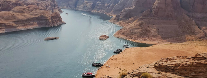
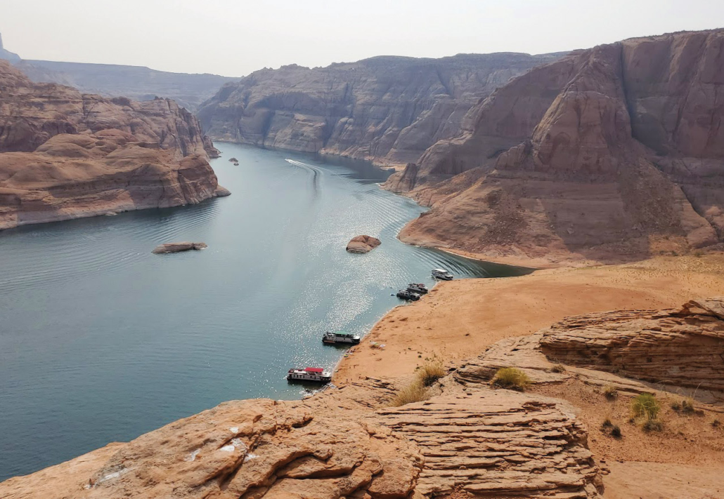
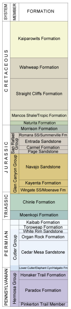
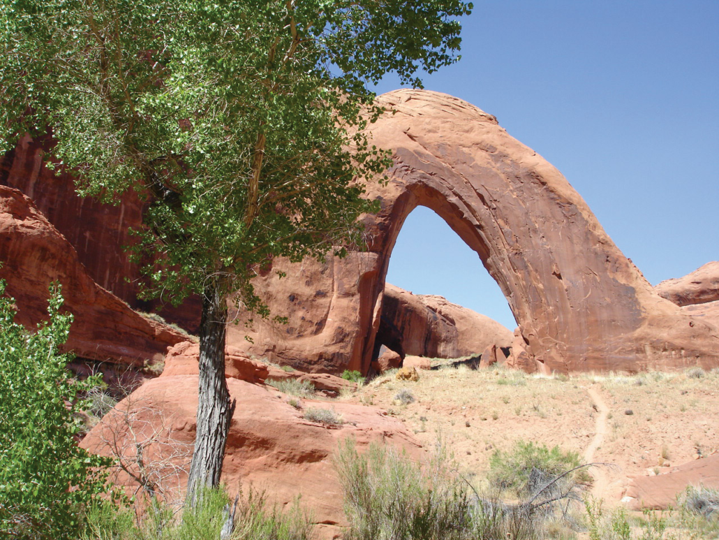
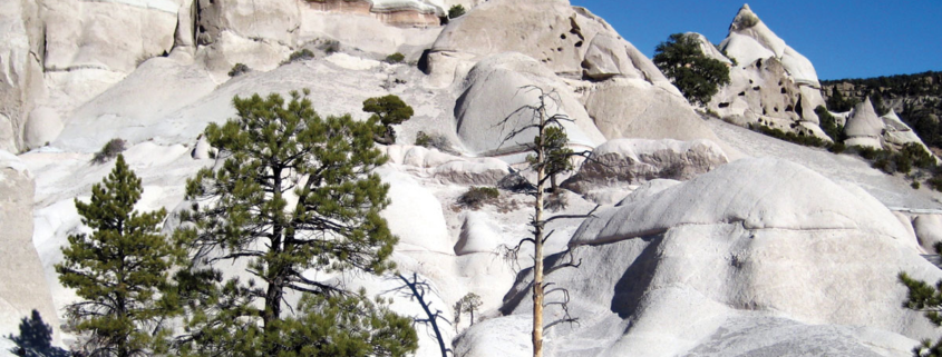
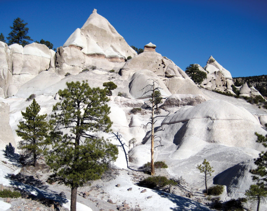
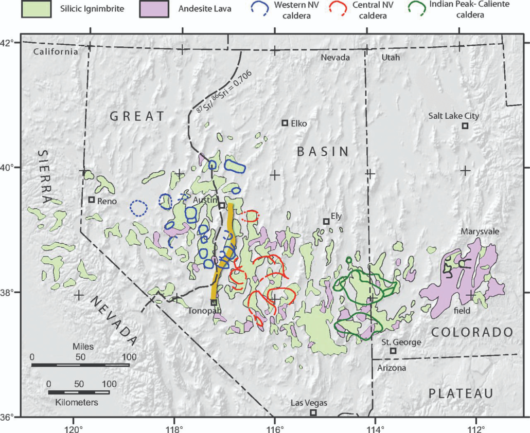
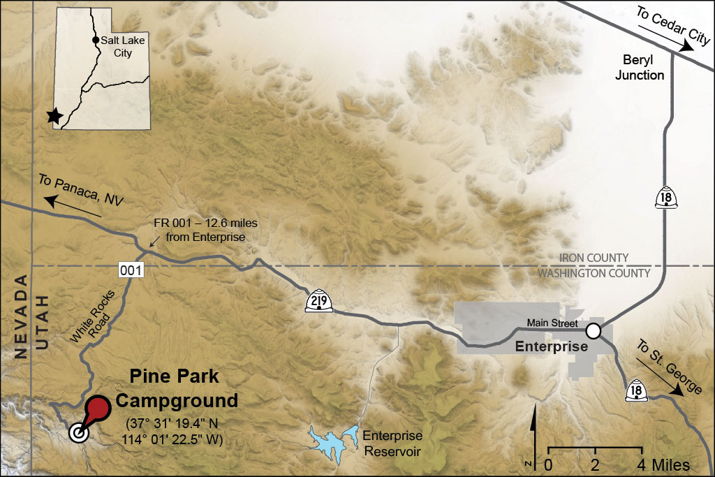
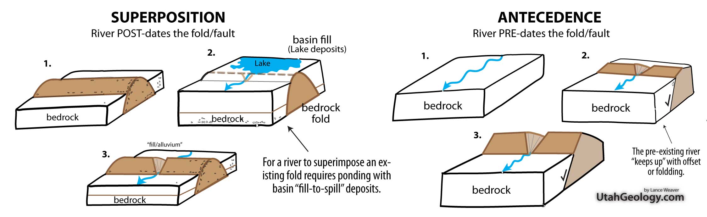
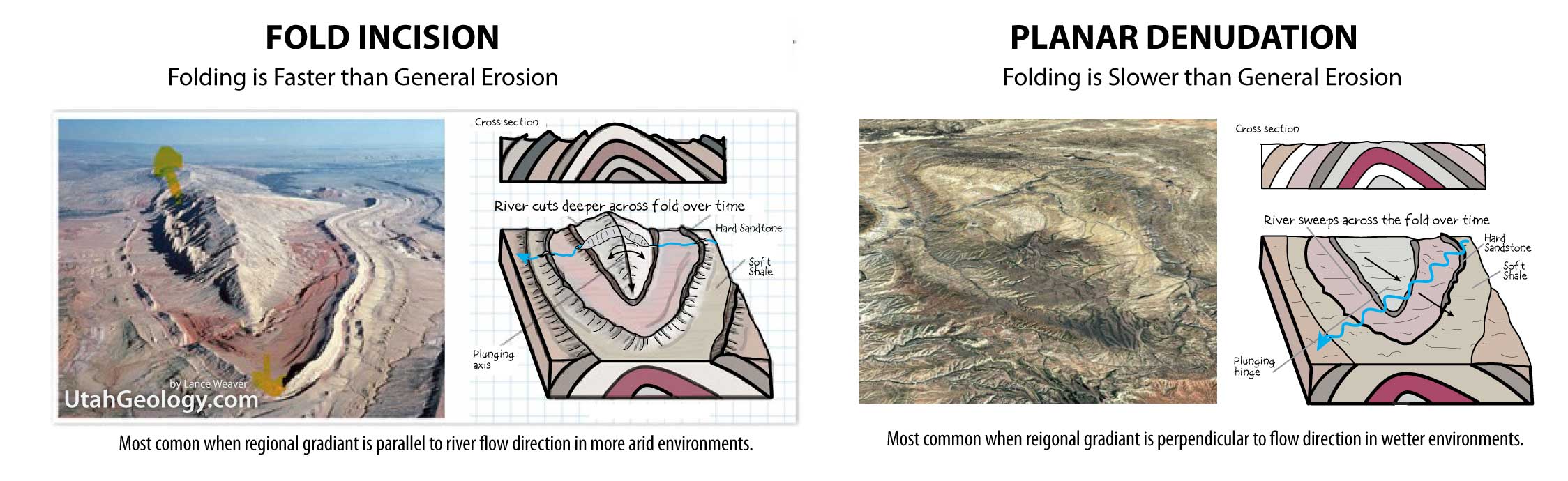
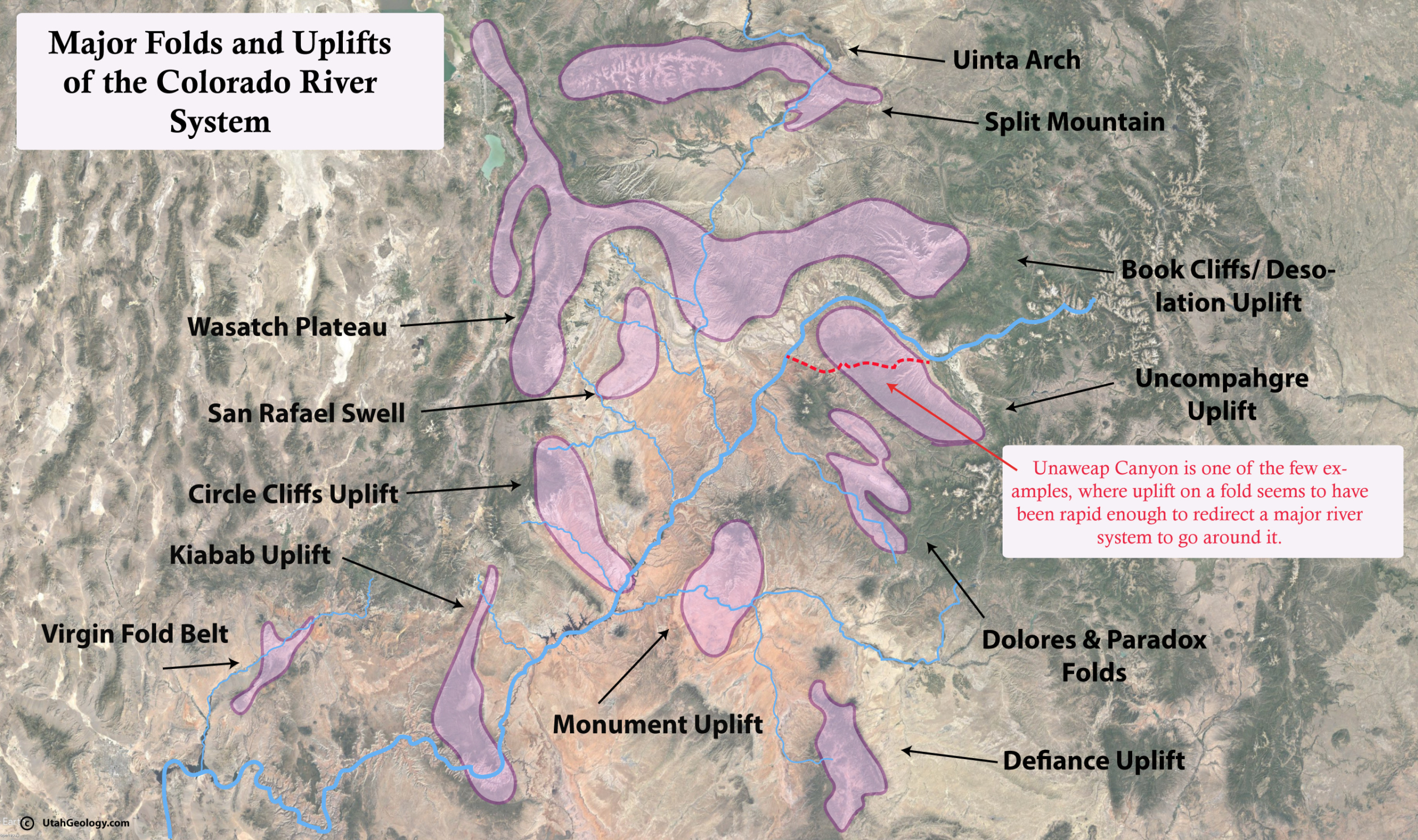
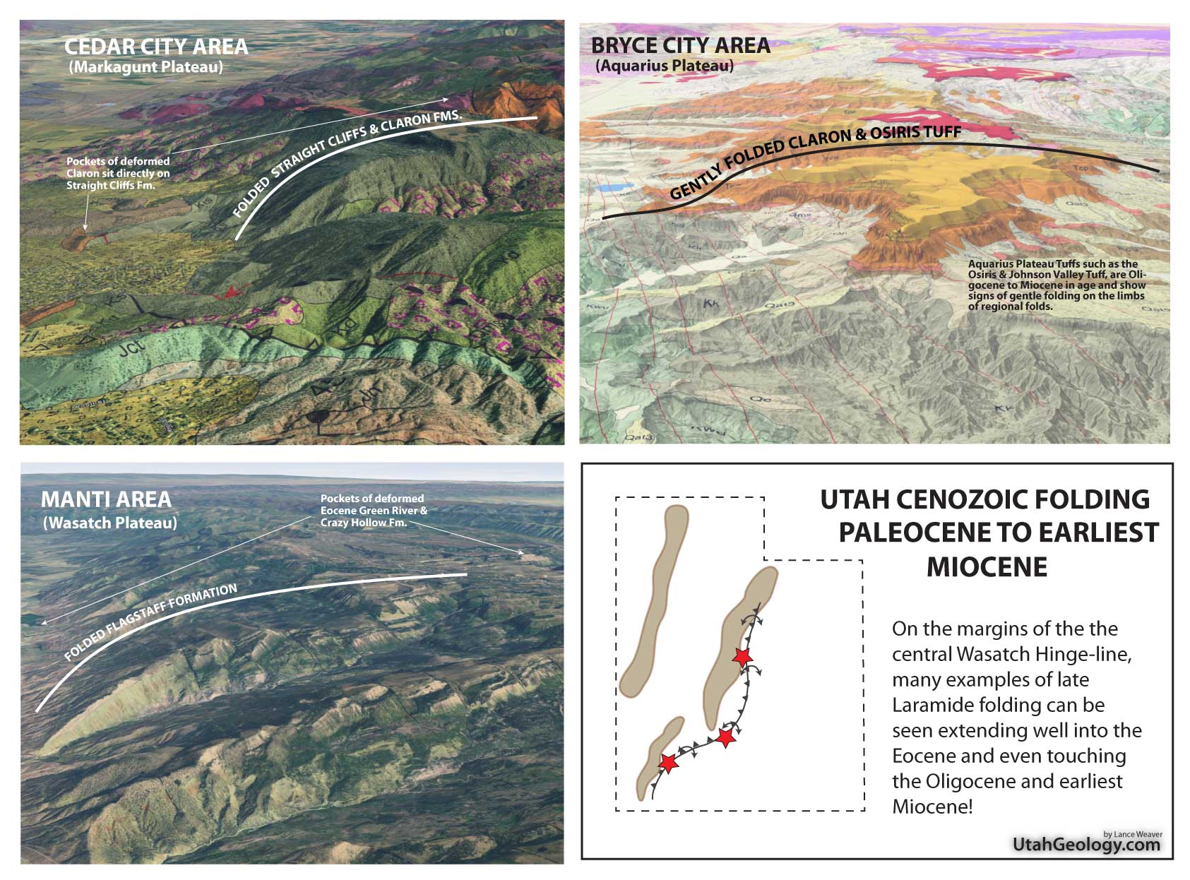
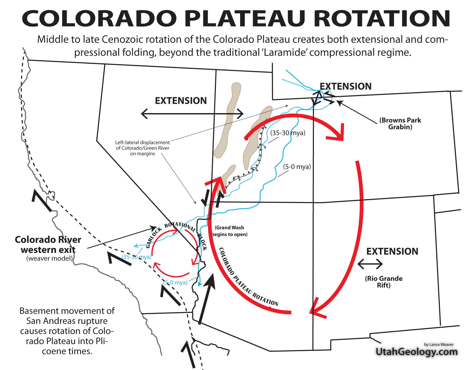
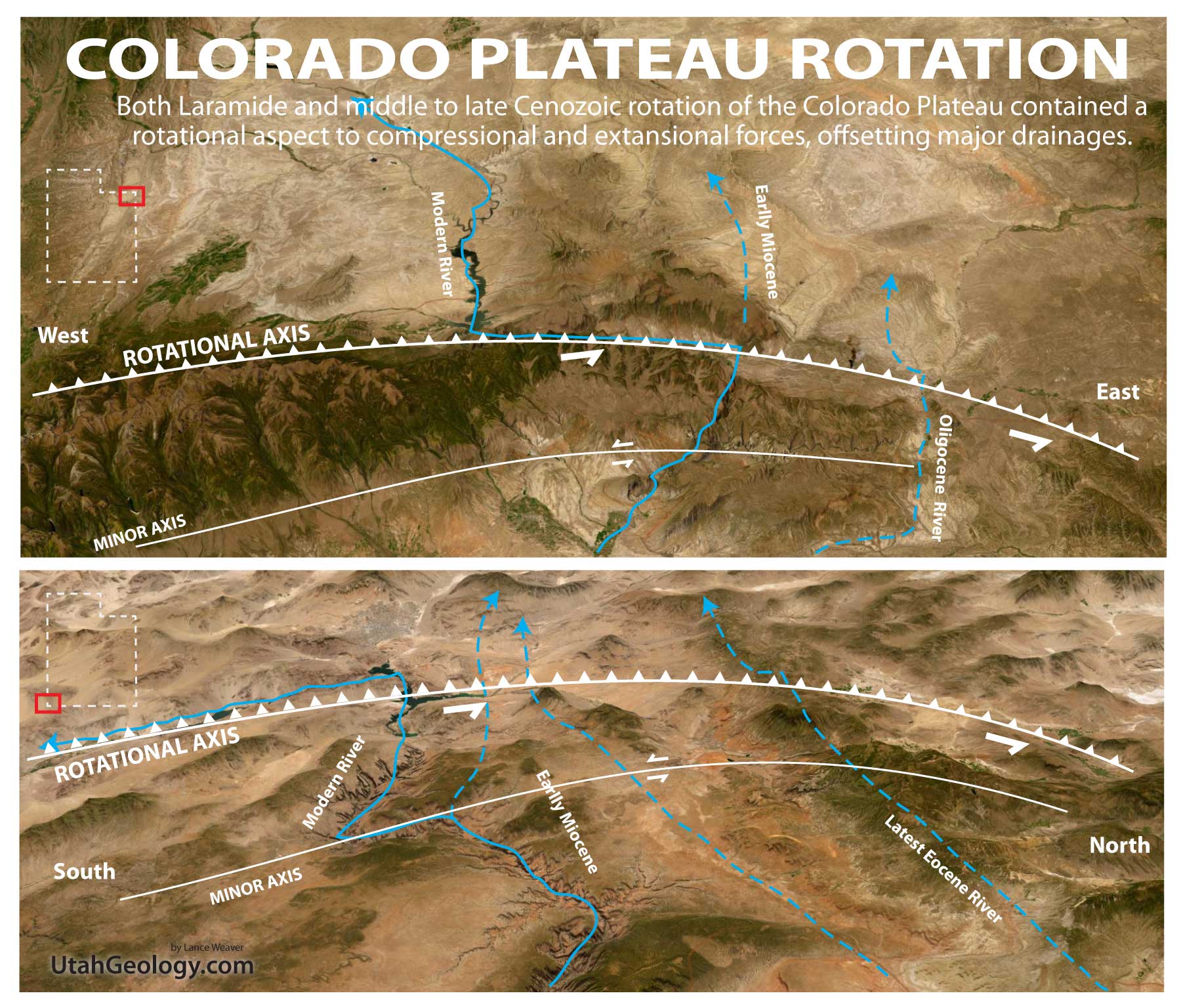
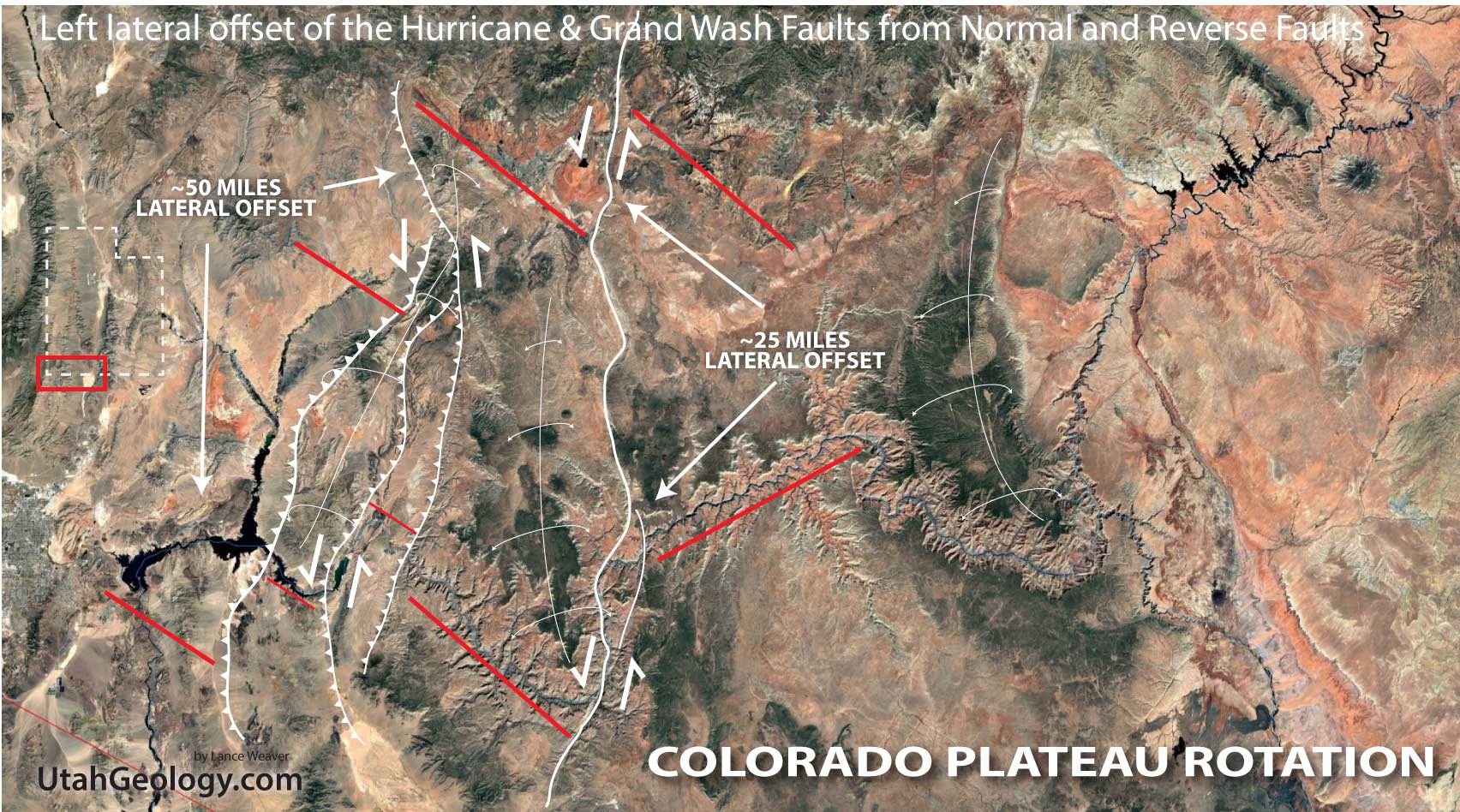

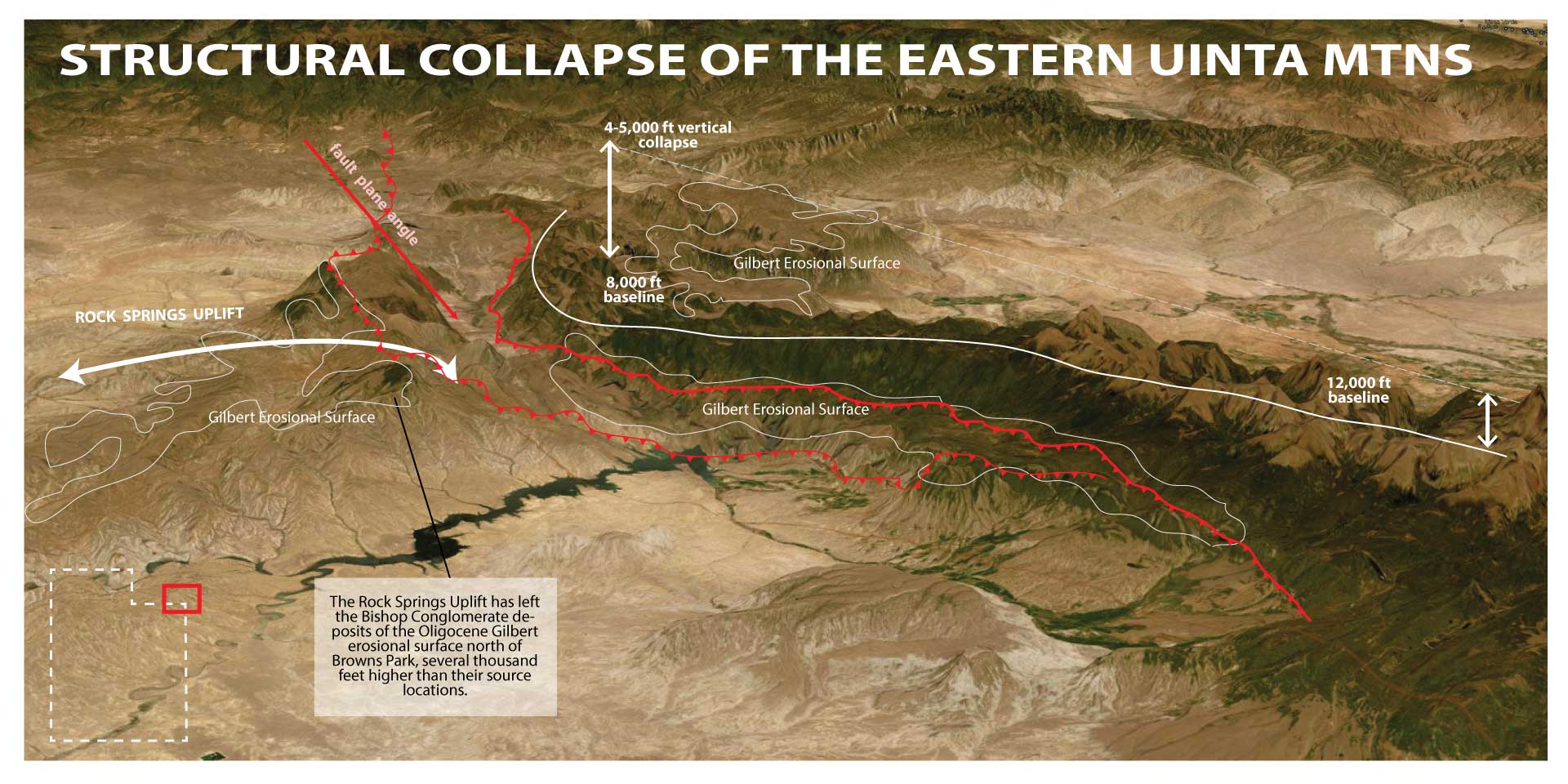

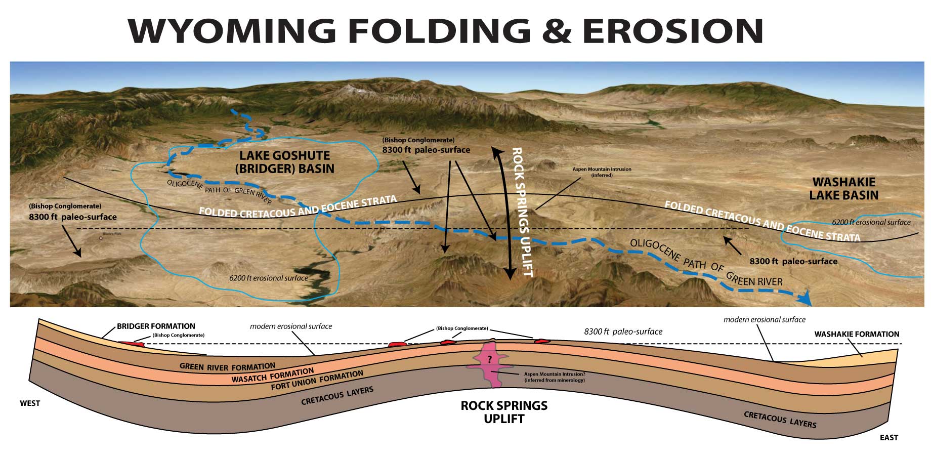
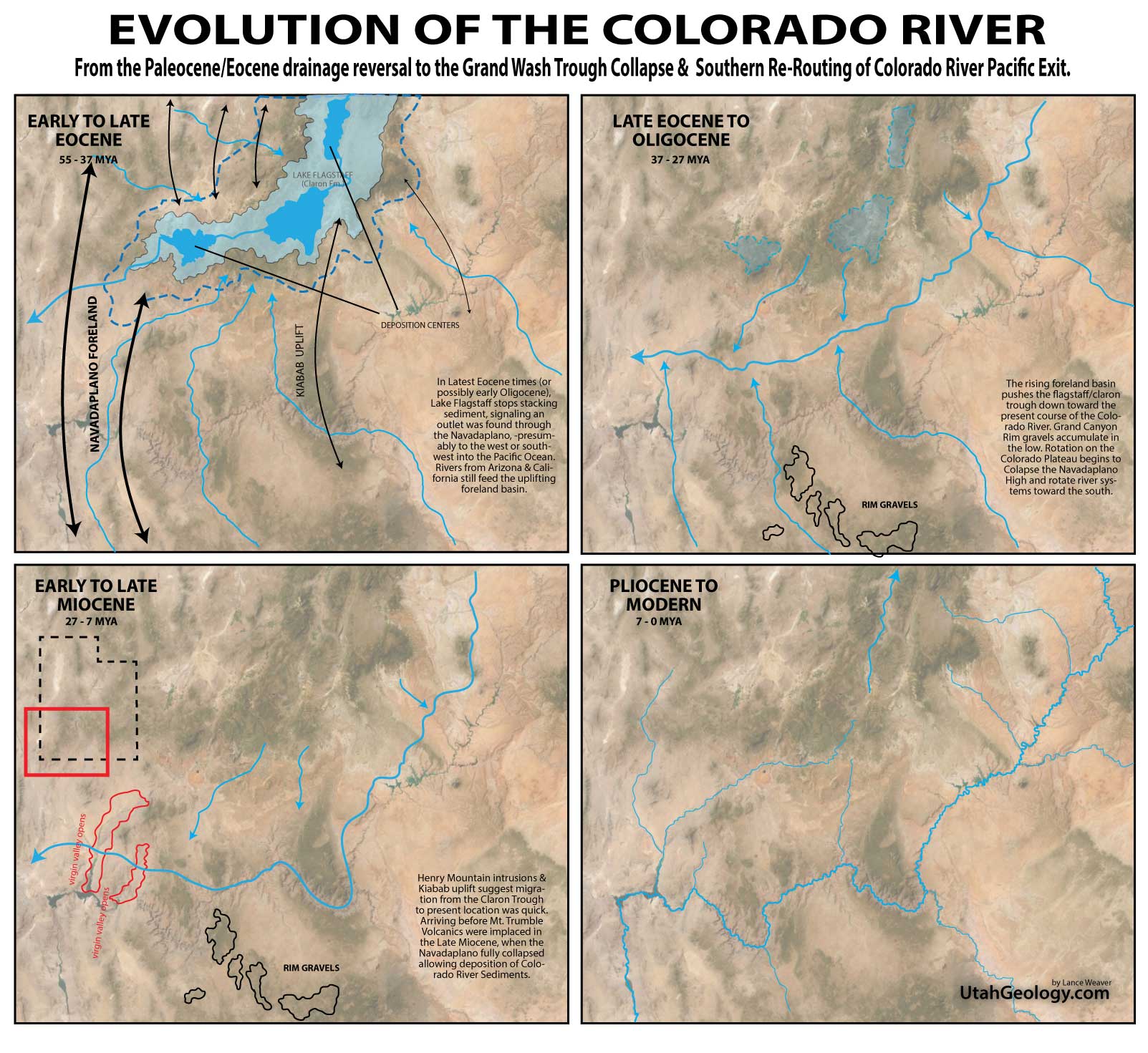
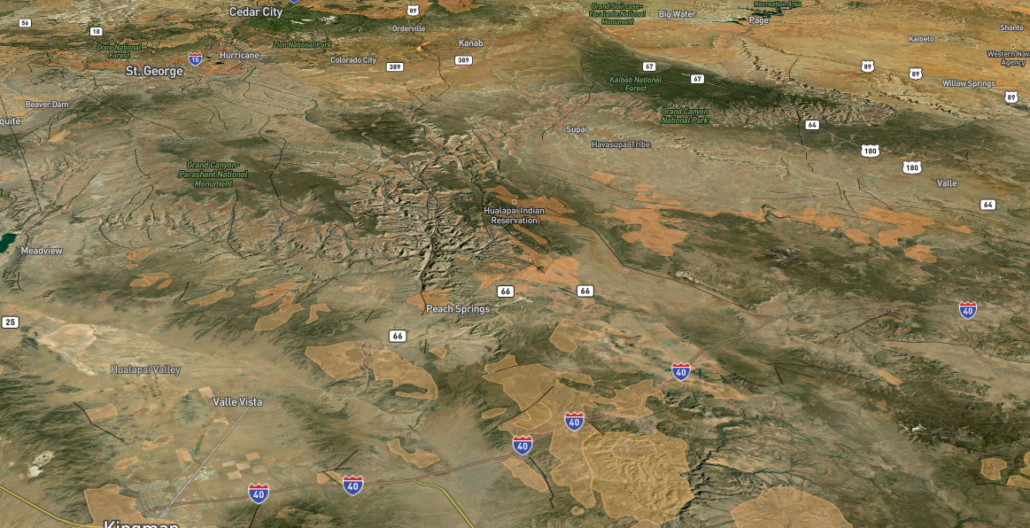
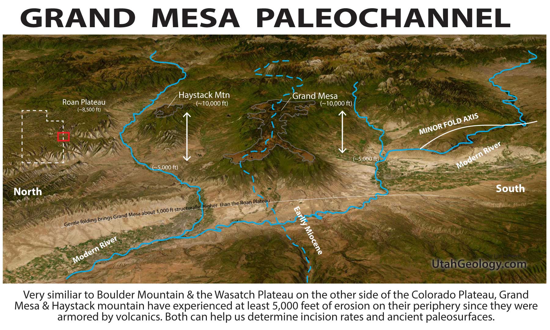
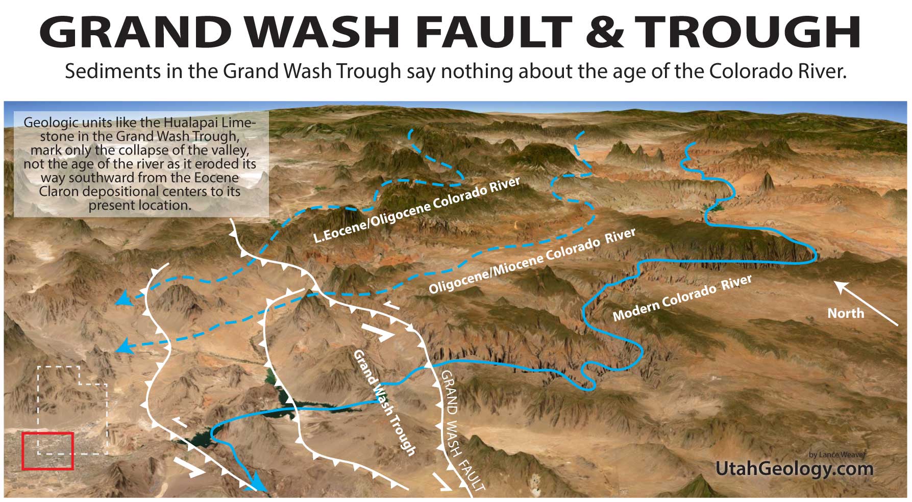
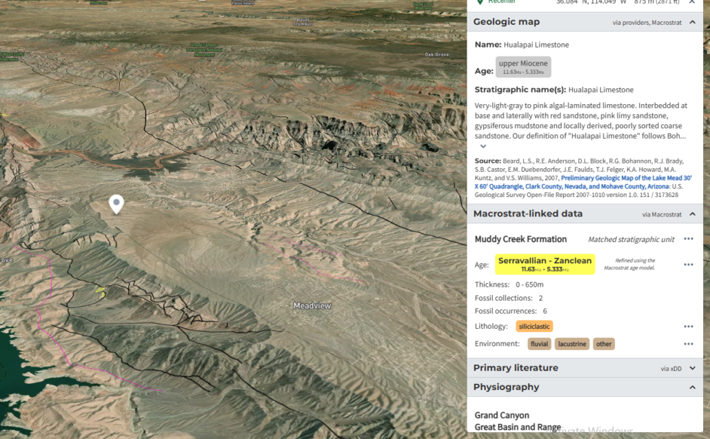
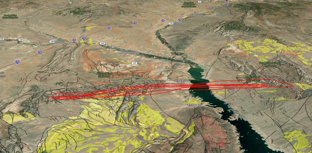
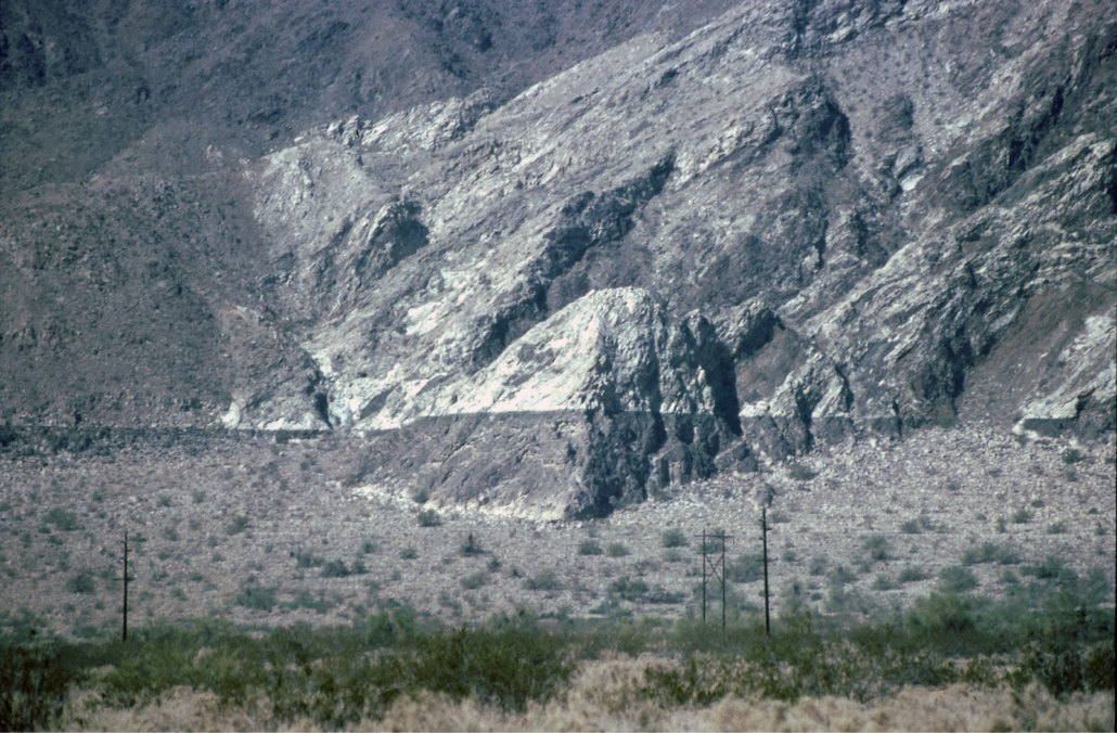
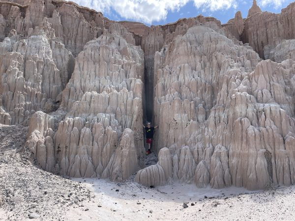

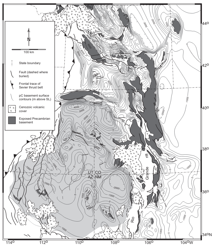
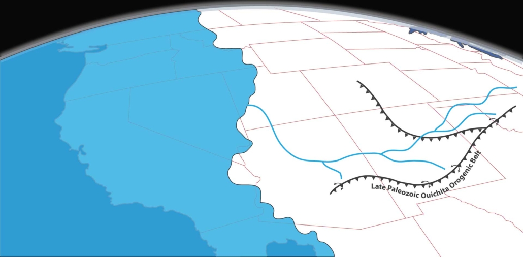
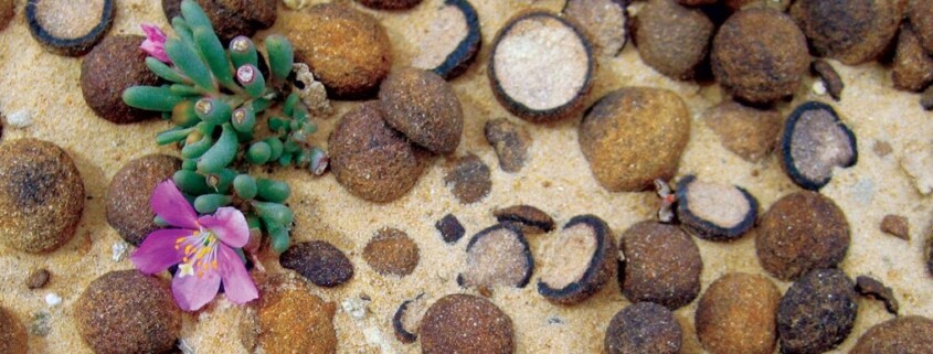
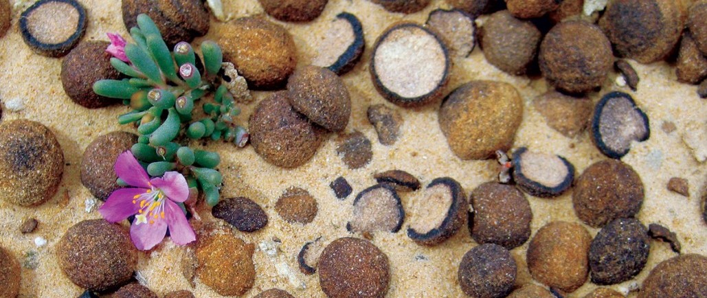
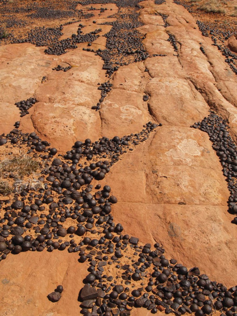
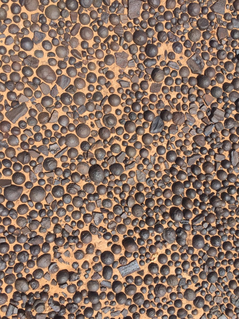
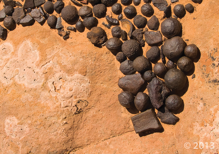
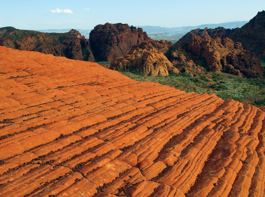
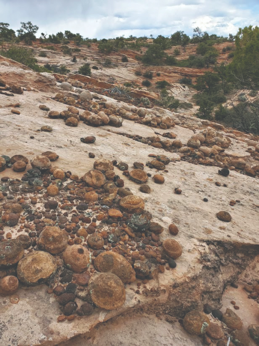
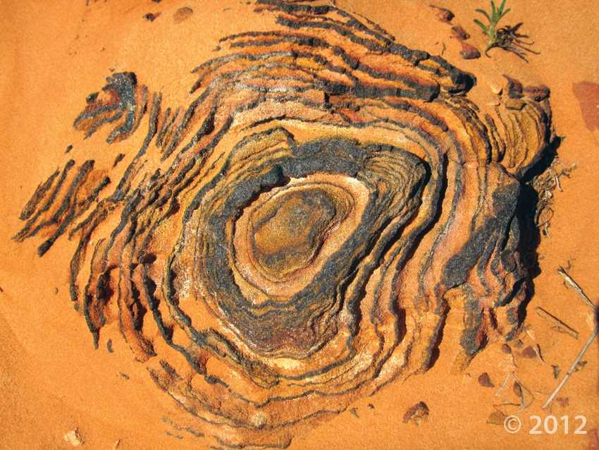
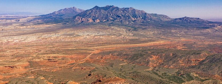
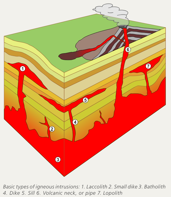
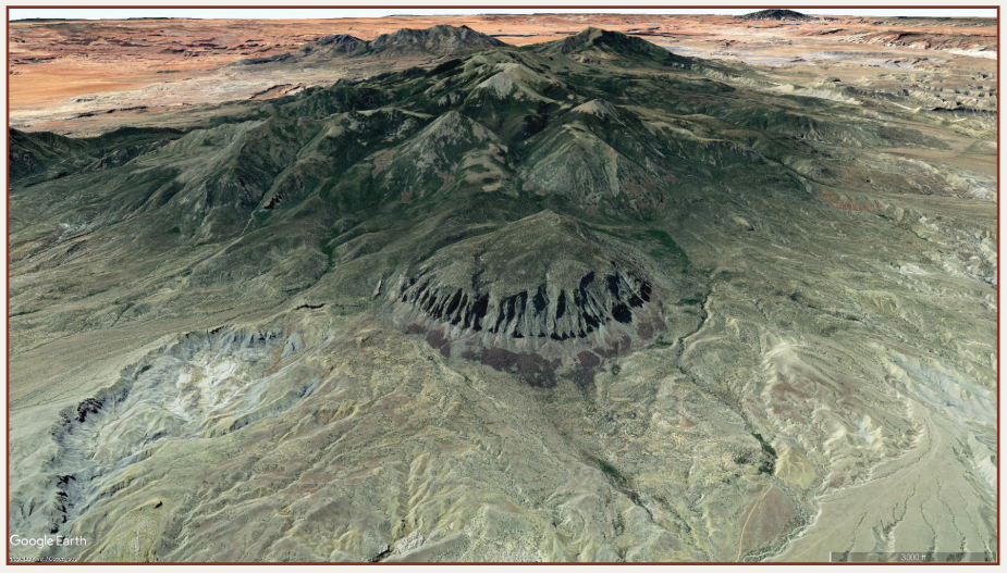
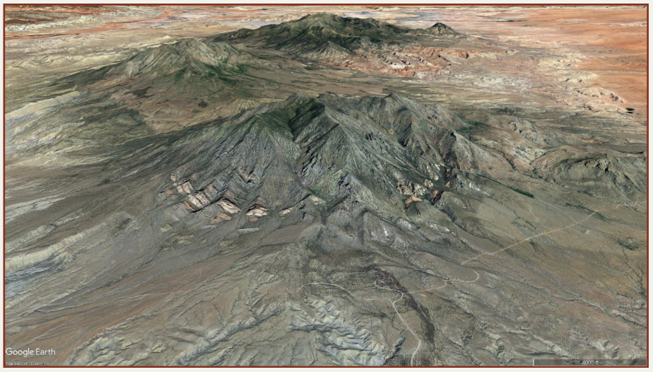
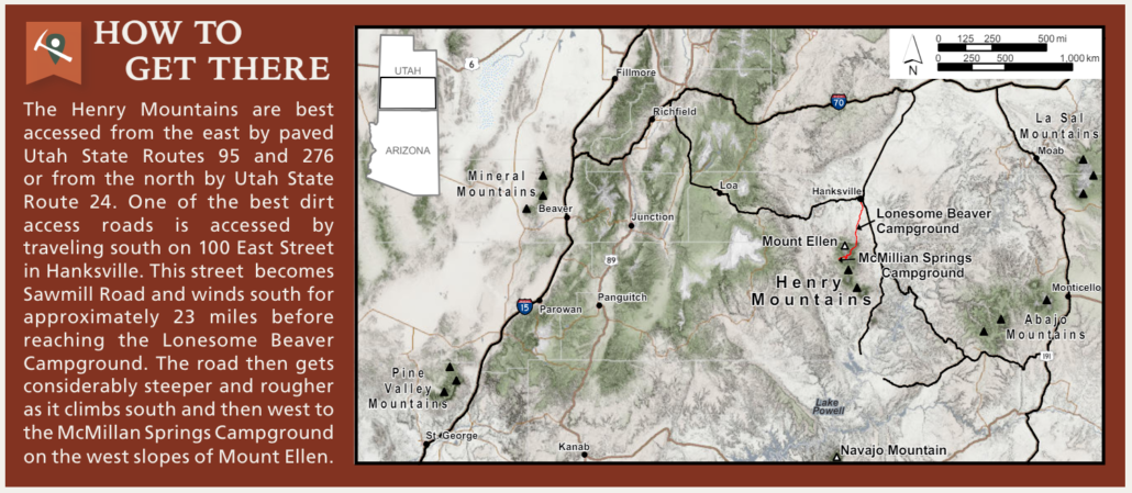
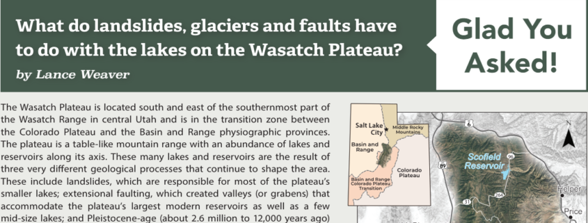
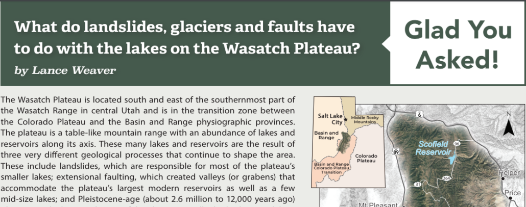
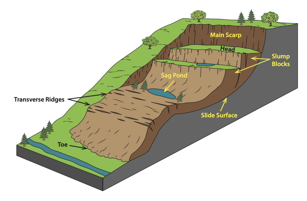
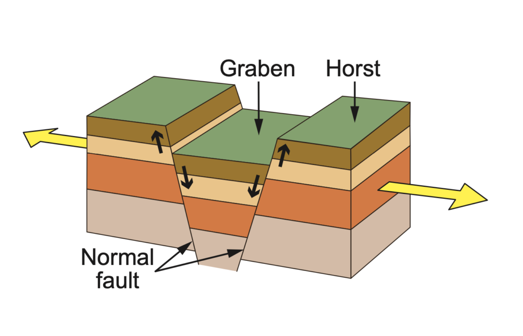

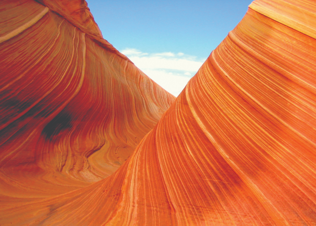
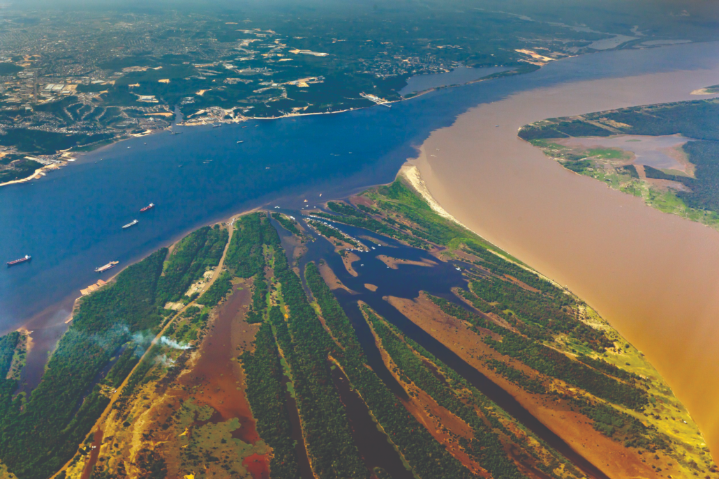

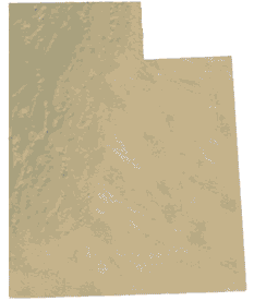
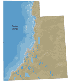 The Cockscomb has a long geologic history that can be simplified into three phases. The oldest layers exposed at the base of this unique geologic feature were deposited between about 270 and 185 million years ago in the Permian to Early Jurassic periods. During this time, Utah was situated on the west coast of North America with much of present-day California and Nevada existing as offshore islands. Warm, shallow seas accumulated thick layers of siltstone and limestone which form the cap rock for much of the Kaibab uplift, but represent the lowest exposed layers of The Cockscomb. As North America drifted westward, Utah was uplifted above sea level, transitioning into a terrestrial environment of west-flowing rivers and streams that deposited thick layers of colorful sediments now exposed in the Vermilion and Chocolate Cliffs of The Cockscomb and Grand Staircase (seen best from Stop #1 on the map).
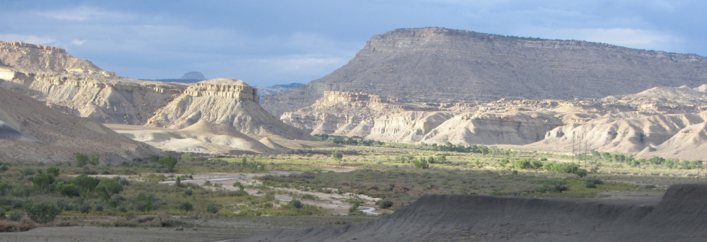
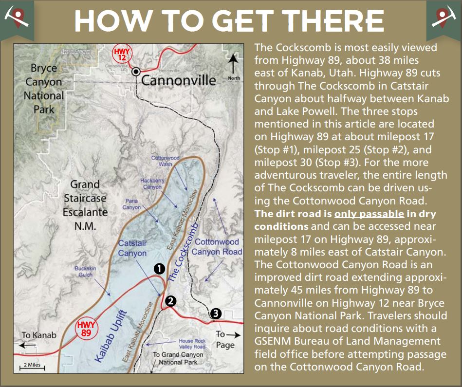
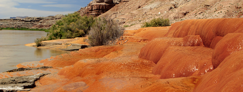
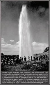
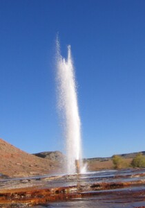 Crystal Geyser is a partially human-made geyser located on the shore of the Green River, approximately 10 miles south of the town of Green River, Utah. The geyser originated in 1936 when an oil exploration well tapped into a groundwater system under immense pressure caused by a reservoir of trapped carbon dioxide (CO2) gas. However, the high-pressure system that the well penetrated had previously created a series of ancient natural springs and tufa deposits which were first referenced by John Wesley Powell in 1869. On his way down from the present town site of Green River and the state park museum which now bears his name, he wrote, “an hour later, we run a long rapid, and stop at its foot to examine some curious rocks, deposited by mineral springs that at one time must have existed here, but are no longer flowing” (Powell, 1875, Report on the Exploration of the Colorado River of the West and Its Tributaries, p. 51–52).
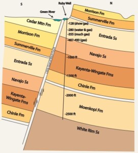 The well was abandoned after drilling to a total depth of 2627 feet, but in its aftermath, a geyser was created that quickly became a regional attraction. The November 1936 front page of Moab’s Times-Independent boasted of a new geyser that spouted an 80-foot column of water at regular intervals of about 15 minutes and a 150-foot column at intervals of about 9 hours.
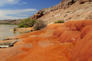
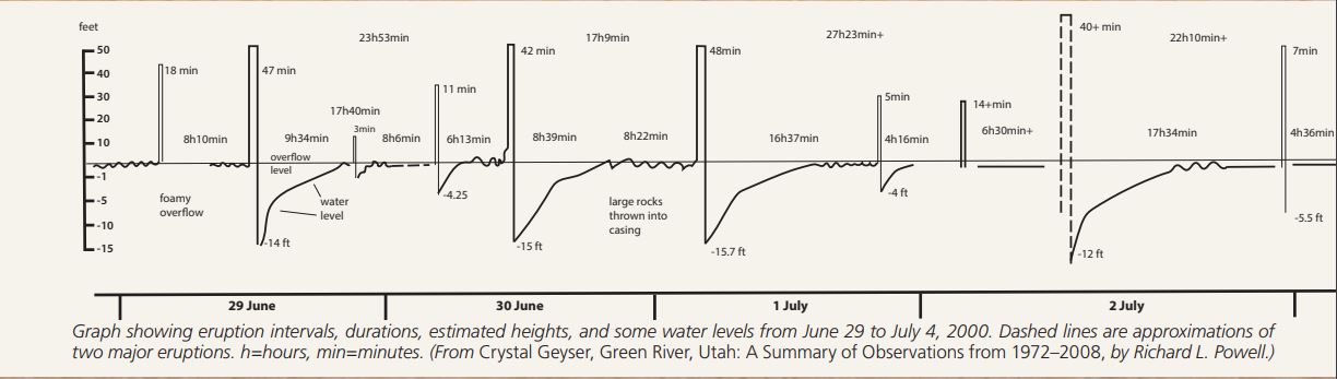
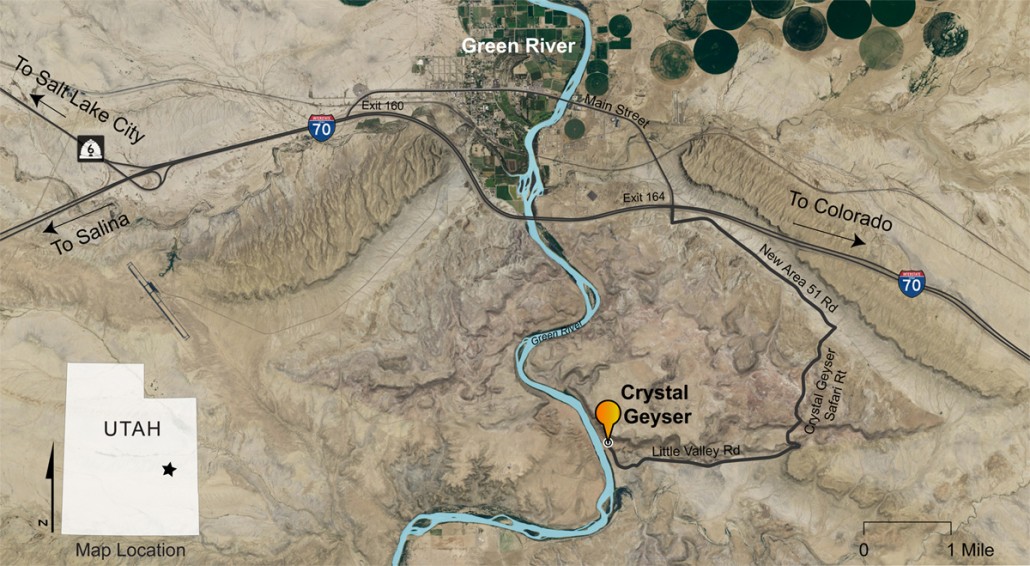
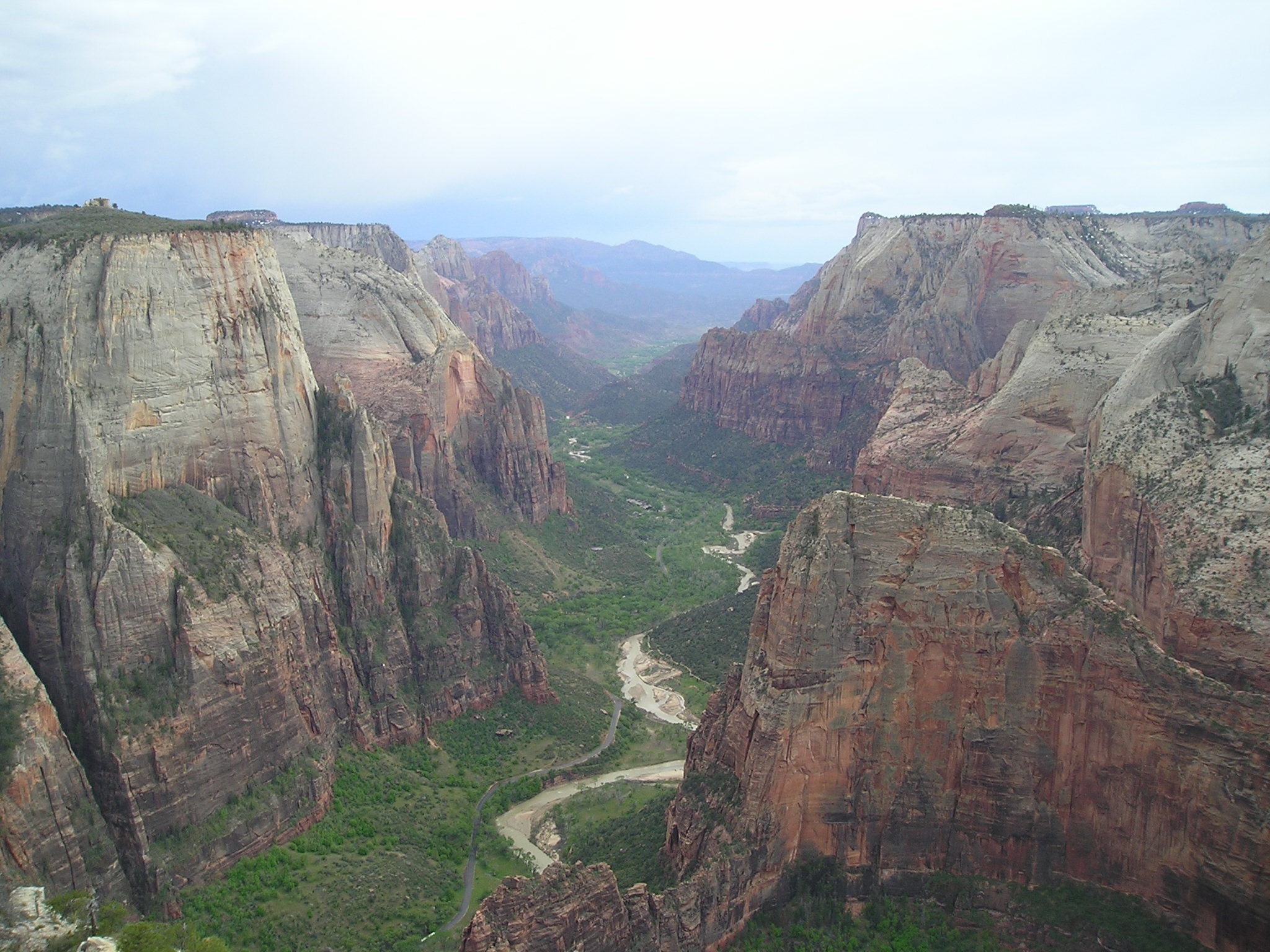
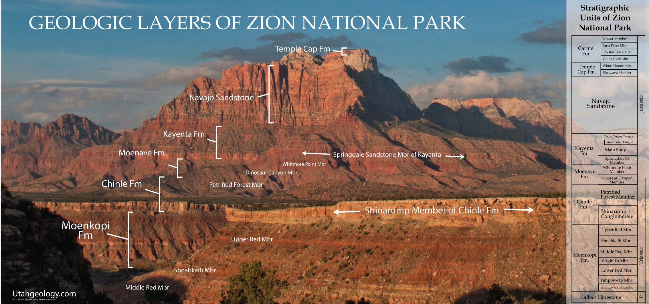


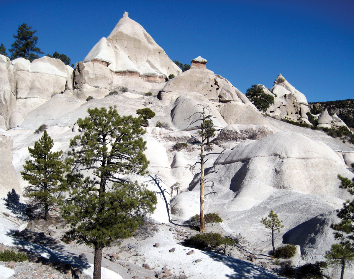
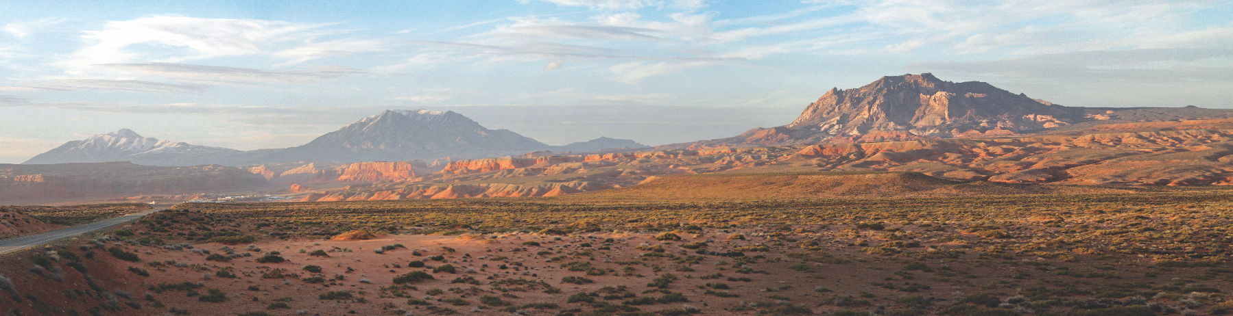
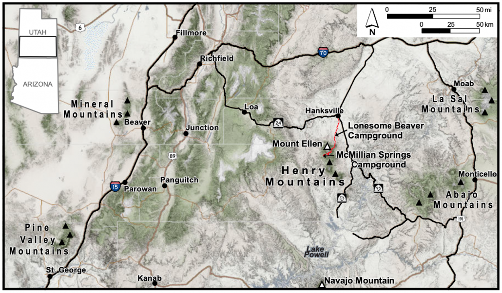
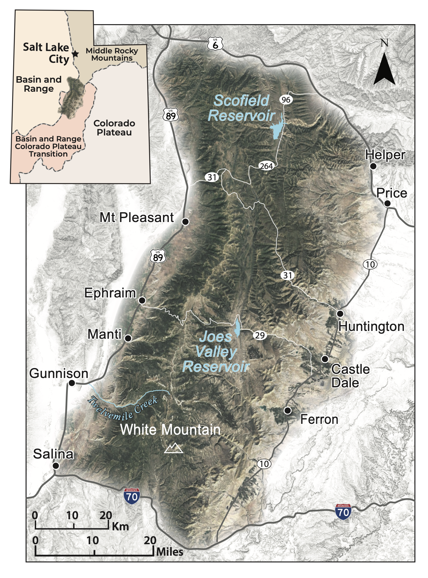
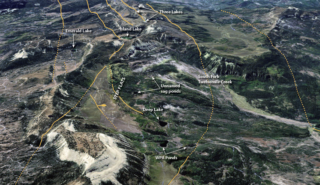
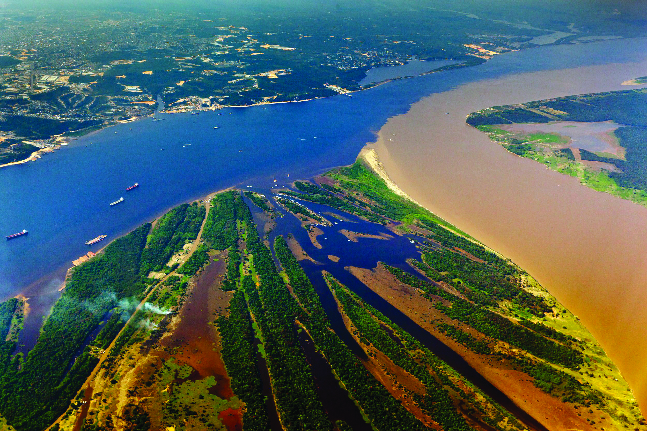
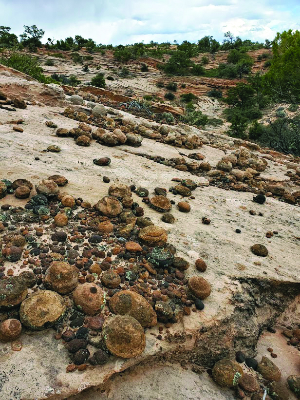