Kayenta Formation (Geology of Utah’s Grand Staircase)
Explore unit thickness in All-in-One App

Exposure:
The Kayenta is exposed throughout the state of Utah, but is especially visible in Zion National Park, Capital Reef and Glen Canyon NRA.
Age: Early Jurassic, 199.6 million years ago to 175.6 million years ago.
Depositional Environment: Fluvial (river) environment
The Navajo Sandstone was deposited in an eolian environment composed of large sand dunes, similar to portions of the modern Sahara Desert. In an eolian environment there are two primary types of deposits: 1) dunes, typified by large-scale trough cross stratification; and 2) interdunes, which are the flat lying areas between dunes.
Paleogeography:
The Wingate erg was reworked by river currents in the time period when the Kayenta formation was being deposited.
Tectonics: The earliest uplift of the Navadaplano and Island arcs (Sierra Navadas) begin to create a rain shadow in early Jurassic (late Kayenta?) times.
Climate: Seasonal climate, rainy summers and dry winters
Features: The Kayenta Formation is Jurassic in age and makes up the middle third of the three-part section that make up the Glen Canyon Group. The Wingate Sandstone is below the Kayenta, while the Navajo Sandstone is above it. The Kayenta Formation is about 350 feet thick and range in color from red, to maroon, to brown (Mathis, 2000).
The Kayenta is composed of sandstones, siltstones, and conglomerates that interbed (or alternate) within each other (Bates et al., 1984). At the top of the Kayenta, where it meets the Wingate, and the bottom of the Kayenta, where it meets Navajo, are contacts that are gradational (Mathis, 2000). Due to this, sometimes it is challenging to differentiate between the Wingate and the Kayenta formations but there are some clues that might aid in discerning the two. The Wingate Sandstone is eolian in origin meaning it was formed/deposited by the wind. In contrast, the Kayenta formation represents a fluvial (pertaining to a river) environment (Bates et al., 1984). According to Friz 1980, the rivers that formed the Kayenta were traveling in a westward to southwestward direction. In the Kayenta, there are small cross-beds (layers of sediment that are tilted at an angle) in contrast to the Navajo and Wingate, which have large cross-beds (Morris et al., 2003). Cross-beds that look like lenses (lenticular) often are indicative of the Kayenta. The Wingate fractures vertically, while the Kayenta fractures horizontally. This fracturing is readily apparent in “the castle” rock structure seen at the Visitors Center of the park (Figure 1). The Kayenta usually weathers as low cliffs and ledges (Morris et al., 2003).

Description:
The red and mauve Kayenta siltstones and sandstones that form the slopes at base of the Navajo Sandstone cliffs record the record of low to moderate energy streams. Poole (1997) has shown that the streams still flowed toward the east depositing from 150 to 210 m (500 to 700 ft) of sediment here. The sedimentary structures showing the channel and flood plain deposits of streams are well exposed on switchbacks below the tunnel in Pine Creek Canyon.
In the southeastern part of Zion National Park a stratum of cross bedded sandstone is found roughly halfway between the top and bottom of the Kayenta Formation. It is a “tongue” of sandstone that merges with the Navajo formation east of Kanab, and it shows that desert conditions occurred briefly in this area during Kayenta time. This tongue is the ledge that shades the lower portion of the Emerald Pool Trail, and it is properly called Navajo, not Kayenta.
Fossil mudcracks attest to occasional seasonal climate, and thin limestones and fossilized trails of aquatic snails or worms mark the existence of ponds and lakes. The most interesting fossils, however, are the dinosaur tracks that are relatively common in Kayenta mudstone.
These vary in size, but all seem to be the tracks of three-toed reptiles that walked upright, leaving their tracks in the muds on the flood plains. Unfortunately, so far no bone materials have been found in Washington County that would enable more specific identification.
Apparently during Kayenta time Zion was situated in a climatic belt like that of Senegal with rainy summers and dry winters at the southern edge of a great desert. The influence of the desert was about to predominate, however, as North America drifted northward into the arid desert belt.
In Southeast Utah, most sections that include all three geologic formations of the Glen Canyon group the Kayenta is easily recognized. Even at a distance it appears as a dark-red, maroon, or lavender band of thin-bedded material between two thick, massive, cross bedded strata of buff, tan, or light-red color. Its position is also generally marked by a topographic break. Its weak beds form a bench or platform developed by stripping the Navajo sandstone back from the face of the Wingate cliffs. The Kayenta is made up of beds of sandstone, shale, and limestone, all lenticular, uneven at their tops, and discontinuous within short distances. They suggest deposits made by shifting streams of fluctuating volume. The sandstone beds, from less than 25 millimetres (1 in) to more than 3 metres (10 ft) thick, are composed of relatively coarse, well-rounded quartz grains cemented by lime and iron. The thicker beds are indefinitely cross bedded. The shales are essentially fine-grained, very thin sandstones that include lime concretions and balls of consolidated mud. The limestone appears as solid gray-blue beds, a few inches to a few feet thick, and as lenses of limestone conglomerate. Most of the limestone lenses are less than 8 metres (25 ft) long, but two were traced for nearly 150 metres (500 ft) and one for 500 metres (1,650 ft).
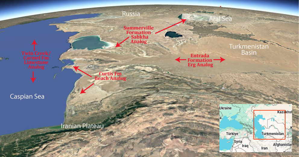
Modern Analog to Utah’s Middle Jurassic
.
Paleogeography or Depiction of Utah during Middle Jurassic
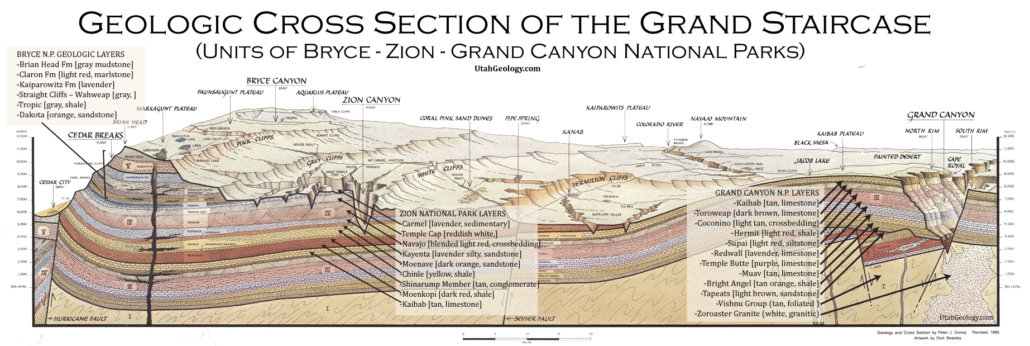
What is the Grand Staircase?
The Grand Staircase is a unique and extensive exposure of Earth’s history, showcasing over 200 million years of sedimentary rock layers. Geologists often liken these layers to a “book,” allowing for a detailed study of the Earth’s past, including changes in climate and environment.
The major sedimentary rock units exposed in the Grand Canyon range in age from 200 million to 600 million years and were deposited in warm shallow seas and near-shore environments. The nearly 40 identified rock layers of Grand Canyon form one of the most studied geologic columns in the world.

[flickr_tags user_id=”95435349@N04″ randomize=”true” margins=”4″ pagination=”numbers” tags=”navajo” max_num_photos=”9″]
[flickr_tags user_id=”95435349@N04″ tags=”chinle, navajo”]