Page Sandstone & Templecap Fm (Geology of Utah’s Grand Staircase)
Explore unit thickness in All-in-One App

Exposure:
The Temple Cap is exposed exclusively in the Southwest corner of Utah (atop the spires of Zion National Park), whereas the Page Sandstone stretches all the way into the center of the state. Both share similiar ages, but the Page is thicker and was formed by a separate erg, with far less marine influence. (ie. the slumping visible in the temple cap as the Sundance seaway covered the dune systems)
Age: Middle Jurassic
Depositional Environment: Eolian, Marginal marine
Paleogeography:
In the Middle Jurassic, Utah lay closer to the equator creating an arid, eolian environment (Blakey 2008). Sedimentation was controlled by sea level, climate and tectonics. The Sundance sea entered the area from the north due to a global sea level rise. This was a time of subsidence most likely due to a sag next to west lying Nevadan highlands. The Page Sandstone is confined to the south central portion of Utah and north central regions of Arizona. Narrowing of the seaway in northern Utah encroached and inundated onto the Page Sandstone erg to cease the eolian deposition.
Tectonics:
In the Middle Jurassic, parts of Utah were in a period of mountain-building phase. Tectonic activity, like the Nevada Orogeny, was centered in the northeast portion of Nevada and volcanic highlands were located to the south and southwest. Folding and thrusting from the orogeny led to subsidence and a foreland basin.
Features:
The Page Formation was a large dune field (erg/eolian system) ranging from northern Arizona, in the Middle Jurassic, that extended northward across a band within Utah to Wyoming (Fillmore 2000). It was separated to the west by a tidal-flat/sabkha complex and then the Sundance seaway. The Sundance seaway expanded and extended southward and eastward and as it retreated, the Page erg followed and expanded over the sabkha sediments. Page Sandstone and the Carmel Formation comprise a mix of marine, sabkha, fluvial systems of the Carmel (marinal marine and marine) and eolian deposits of the Page Sandstone.


Description:
The Page Sandstone is the deposit of the Page coastal dune field during the Jurassic. It overlies and in is separated from the Navajo Sandstone by the continental-scale J2 unconformity. During the Jurassic, the adjacent Carmel Sea experienced several fluctuations in sea level, affecting the position of the water table in the Page Erg. Highstands in the Carmel are associated with high watertable elevations in the Page dune field that are tied to development of polygonally-fractured sabkha surfaces, and the preservation of some portion of underlying aeolian cross-strata. The packages of lowstand aeolian strata, bounded by sabkha deposits and/or polygonally-fractured surfaces represent parasequences within the overall transgressive succession of the Page Sandstone.
The occurrence of an extensive wet sabkha surface prohibited dune field development and this lack of wind-blown sand lead to surface deflation down to elevation of the water table. As such, each parasequence bounding surface represents a reset of the dune field pattern, and provides an opportunity to correlate stratigraphic architecture to paleo-environmental conditions
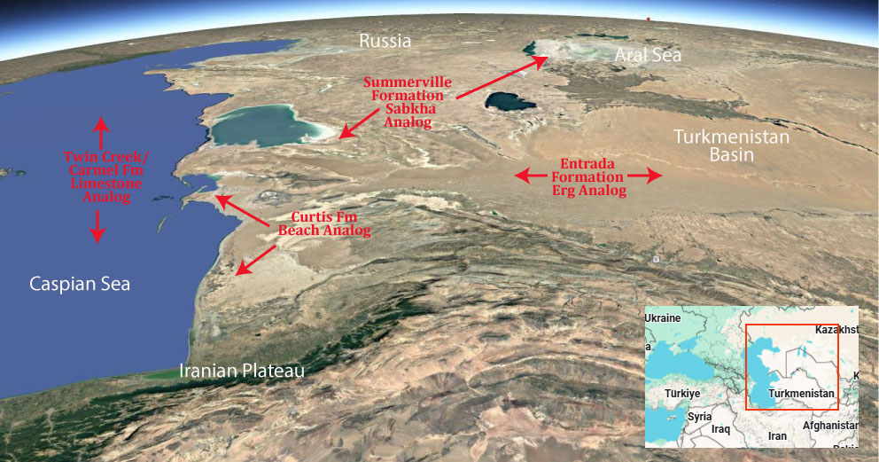
Modern Analog to Utah’s Middle Jurassic
.
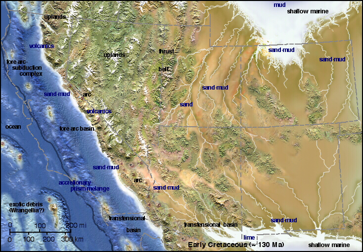
Paleogeography or Depiction of Utah during Middle Jurassic
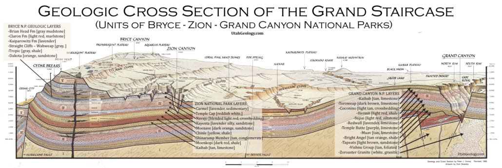
What is the Grand Staircase?
The Grand Staircase is a unique and extensive exposure of Earth’s history, showcasing over 200 million years of sedimentary rock layers. Geologists often liken these layers to a “book,” allowing for a detailed study of the Earth’s past, including changes in climate and environment.
The major sedimentary rock units exposed in the Grand Canyon range in age from 200 million to 600 million years and were deposited in warm shallow seas and near-shore environments. The nearly 40 identified rock layers of Grand Canyon form one of the most studied geologic columns in the world.

[flickr_tags user_id=”95435349@N04″ randomize=”true” margins=”4″ pagination=”numbers” tags=”navajo” max_num_photos=”9″]
[flickr_tags user_id=”95435349@N04″ tags=”chinle, navajo”]