Carmel Formation (Geology of Utah’s Grand Staircase)
Explore unit thickness in All-in-One App

Exposure:
Within the Grand Staircase, the Carmel Formation is best exposed in east of Capital Reef National Park just south of Goblin Valley State Park.
Age: Middle Jurassic, 160 Ma
Depositional Environment: Full marine, shallow marine to sabkha (and supratidal)
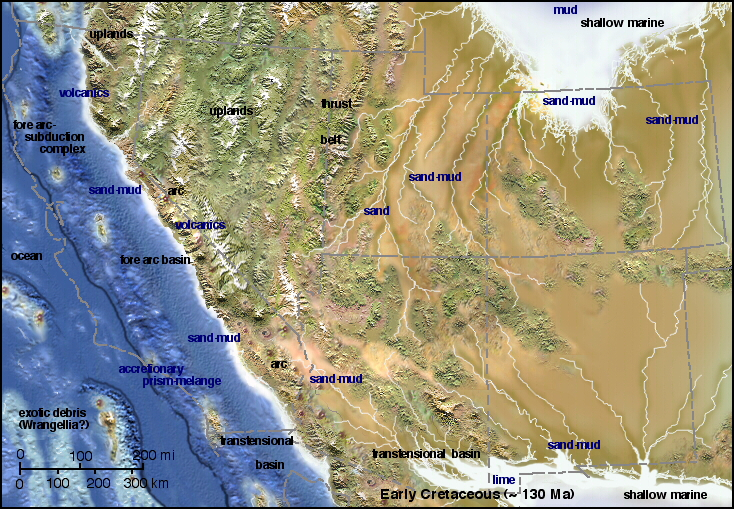
Paleogeography:
Frequent, but short-lived sea level fluctuations during the Middle to Late Jurassic caused periodically flooding from shallow extensions of the ocean. Flooding deposited gypsum, sand, and limey silt in depressed blocks of land that were bordered by parallel faults (grabens), and were periodically covered by sea water. Evaporites were deposited from repeated flooding during this time.
Tectonics:
Stable, some volcanism with subduction to the west.
Climate:
With paleolatitude range of 5 to 25 degrees north, the paleoclimate was both hot and arid (Kocurek & Dott, 1983).
Features:
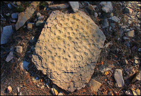
The Carmel Formation is composed of 200 to 1,000 feet (60 to 300 m) of reddish-brown siltstone, mudstone and sandstone that alternates with whitish-gray gypsum and fossil-rich limestone in a banded pattern. Fossils include marine bivalves and ammonites. The Carmel formation contains massive limestone beds in varying shades of gray, but also contains brittle limestone beds that weather into hard angular chips. The limestone beds can also be sandy and some contain ripple marks. Various types of soft sediment deformation also characterize the Carmel Formation. Typical Carmel exposures occurs as a series of low cliffs and steep slopes. In some areas, the Carmel Formation forms a resistant cap and slows the erosion of the underlying Navajo Sandstone.
Description:
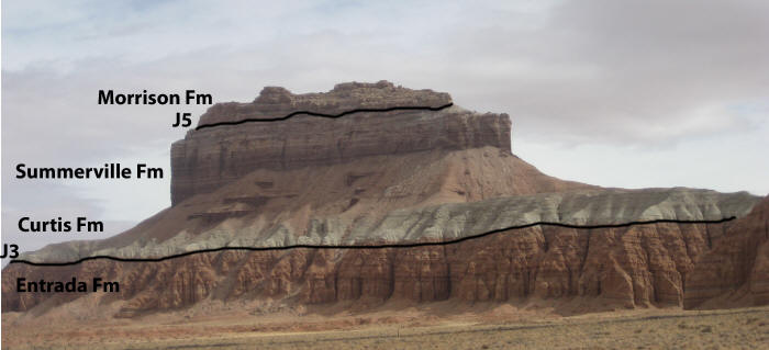
The Carmel Formation consists of up to 1,000 feet (300 m) of mudrock and sandstone interbedded with limestone and gypsum. It was laid down in a shallow marine to sabkha environment,[1] into which terrigenous sediment was periodically carried. This gives the formation considerable lithological complexity.[3] The formation is underlain by the Navajo Sandstone, with the regional J-2 unconformity separating the two formations, or by the Temple Cap Formation. Portions of the Carmel Formation grade laterally eastward into the Page Sandstone.[2] The Carmel Formation in turn is overlain by the Entrada Formation.[3]
In the type area of southern Utah, the Carmel Formation is divided into the Judd Hollow Member, a basal limestone member; the Crystal Creek Member, mostly mudstone and siltstone, which grades into the Page Sandstone to the east; the Paria River Member, which is also siltstone and mudstone but is separated from the Crystal Creek Member by gypsum beds; and the Winsor Member, which is mudstone, sandstone, and siltstone separated from the Paria River by a basal limestone. Further east, the limestone marker bed pinches out, and the Winsor Member and Paria River Member become indistinguishable and are informally termed the upper member. The upper member contains volcaniclastic beds of rhyolite originating in a volcanic arc just off the edge of the Colorado Plateau.[4]
The formation preserves a Jurassic hardground, rare for North America
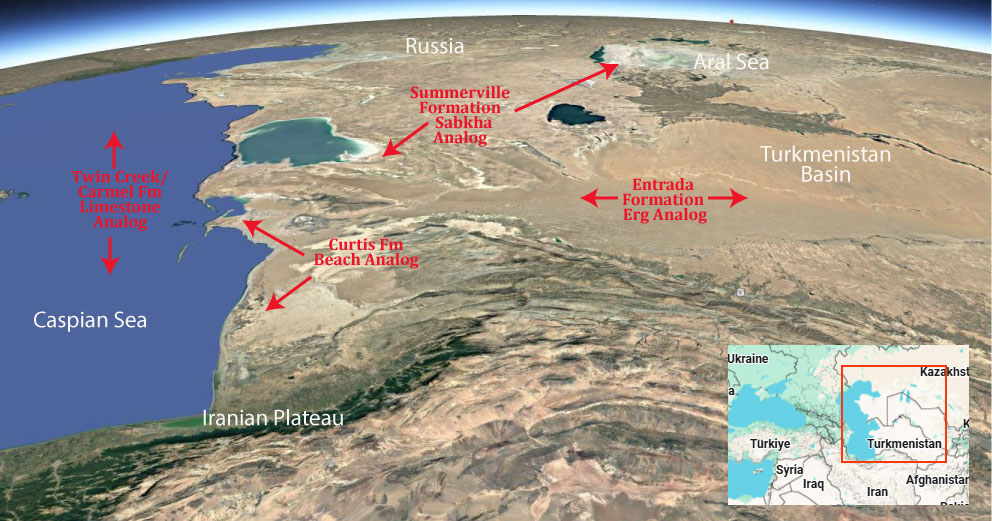
Modern Analog to Utah’s Middle Jurassic
.
Paleogeography or Depiction of Utah during Middle Jurassic
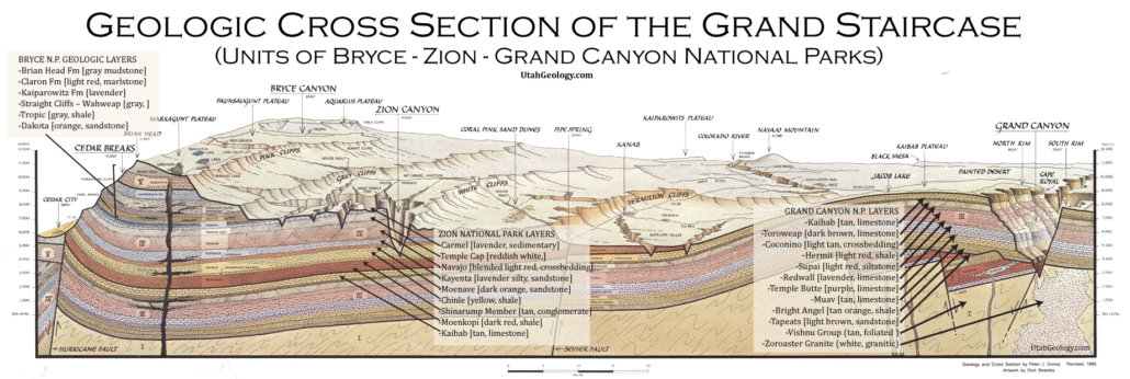
What is the Grand Staircase?
The Grand Staircase is a unique and extensive exposure of Earth’s history, showcasing over 200 million years of sedimentary rock layers. Geologists often liken these layers to a “book,” allowing for a detailed study of the Earth’s past, including changes in climate and environment.
The major sedimentary rock units exposed in the Grand Canyon range in age from 200 million to 600 million years and were deposited in warm shallow seas and near-shore environments. The nearly 40 identified rock layers of Grand Canyon form one of the most studied geologic columns in the world.

[flickr_tags user_id=”95435349@N04″ randomize=”true” margins=”4″ pagination=”numbers” tags=”navajo” max_num_photos=”9″]
[flickr_tags user_id=”95435349@N04″ tags=”chinle, navajo”]