Chinle Formation (Geology of Utah’s Grand Staircase)
Explore unit thickness in All-in-One App

Exposure:
The Chinle formation can be found throughout the Colorado Plateau. From the Flanks of the Uintas to Petrified Forest National Park in Arizona.
Age: Late Triassic.
Depositional Environment: N
on-marine fluvial channels, floodplains, paleosols, marshes, and small lakes.
Paleogeography: The Chinle Formation was deposited during the Late Triassic when the supercontinent Pangea had landmass on both sides of the equator. Utah lay at the paleolatitude of 15° N. On the western margin of the continent (the approximate location of California today) and in southern Arizona into Mexico, subduction complexes contributed the volcanic ash to the bentonitic beds in the Chinle Formation (Prochnow et al., 2006.) East of Utah, the Uncompahgre highlands was a sediment source for Chinle deposits. (Prochnow et al., 2006)
Tectonics: The basinal area (created by tectonism) was subsiding significantly enough to provide enough accommodation space to capture and accumulate eolian sediment (Kocurek and Dott 1983).
Climate: The beginning of Chinle deposition was dominated by wet environments such as stream systems, lakes, wetlands, and deltaic distributary channels. Eventually the climate shifted and dryer environments prevailed such as seasonal stream systems and floodplains. By the end of the Chinle time, eolian deposits (sand dunes) indicate arid conditions.
Features: Uranium-rich conglomeratic sandstones in the Shinarump Member.
This resistant basal unit is typically white, yellow, or gray in color. Sandstone structures within this subfacies include lenticular internal scour surfaces, large trough cross beds, and some horizontal laminations. The sandstone grades laterally into siltstone and mudstone lenses which contain organic carbon fragments as well as carbonized plant fossils (Dubiel, 1987). The Shinarump Member is a coarse-grained conglomeratic sandstone that represents a widespread fluvial channelbelt.
Colorful variegated mudstones and bentonitic sediments in the Monitor Butte Member are gentle slope formers of the characteristic Chinle “badlands”.
There is a gradational contact between the Shinarump and overlying Monitor Butte Member which is purple, yellow, and white mottled sandy siltstone and sandstone. This unit is known as the purple mottled unit (PMU), the color variations occur from different concentrations of iron bearing minerals (Dubiel, 1987). This unit contains lungfish burrows and represents a fluctuating water table which formed oxidizing and reducing environments which redistributed the iron in the sediments (Dubiel, 1987), along with fragments of plant material. The black mudstone has abundant conchostracans, fish scales, fragments of fish bone, and lenses of coal. This unit represents lacustrine marsh bog and wetland environments. Limestone, bentonitic sandstone, and siltstone occur above the coal units. Overall, the Monitor Butte Member was an extensive system of fluvial (stream) and deltaic distributary channels and splays, lacustrine (lake), prodelta and deltaic deposits (Dubiel, 1987).
Carbonized and Petrified Wood in the Monitor Butte Member.
Above the Moss Back Member, lavender and brown variegated mudstone and sandstone of the Petrified Forest Member (Dubiel, 1987 has bentonites (volcanic ashes), thin lenses of carbonate nodule conglomerate, and sandy units with large scale internal scour surfaces and large trough cross-stratification. Important fauna include abundant vertebrate remains, gastropods, lungfish tooth plates, and unionid thin shelled bivalves. This unit represents fluvial sandstone and floodplain mudstones and laterally restricted marsh mudstones. It was deposited by sinuous streams and had many avulsion (redirection of the stream) events.
The Petrified Forest Member interfingers with pink and green limestone and red to orange siltstone of the Owl Rock Member. The limestone has mottled coloration and contains lungfish burrows and ostracodes. This indicates lacustrine basins and lacustrine margin deposition (Dubiel, 1987).


Description:
The Chinle Formation is an Upper Triassic continental geological formation of fluvial, lacustrine, and palustrine to eolian deposits spread across the U.S. states of Nevada, Utah, northern Arizona, western New Mexico, and western Colorado. In New Mexico, it is often raised to the status of a geological group, the Chinle Group. Some authors have controversially considered the Chinle to be synonymous to the Dockum Group of eastern Colorado and New Mexico, western Texas, the Oklahoma panhandle, and southwestern Kansas. The Chinle Formation is part of the Colorado Plateau, Basin and Range, and the southern section of the Interior Plains.[1] A probable separate depositional basin within the Chinle is found in northwestern Colorado and northeastern Utah. The southern portion of the Chinle reaches a maximum thickness of a little over 520 meters (1,710 ft). Typically, the Chinle rests unconformably on the Moenkopi Formation.
The Chinle Formation was probably mostly deposited in the Norian stage, according to a plethora of chronological techniques. It is a thick and fossiliferous formation with numerous named members (subunits) throughout its area of deposition.
The Chinle continues northwards into southern Utah and the Four Corners area, though it thins greatly to the northwest. A narrow band of undifferentiated purplish sediments from the lower part of the formation extend into vicinity of St. George. The formation thickens eastward into Zion National Park and Grand Staircase–Escalante National Monument. The Chinle is a prominent component of badlands and outcrops in the various national parks, monuments, and recreation areas of southeast Utah, extending in a discontinuous patchwork up to the San Rafael Swell.[24][25] The stratigraphic nomenclature used in southern Utah is also utilized in Monument Valley, where the coarse-grained lower members of the Chinle form a caprock for many famous buttes which characterize the valley.[7]
In this region, the stratigraphically lowest unit in the Chinle is usually the Shinarump Conglomerate (or Shinarump Member), which thins northward but is a reliable component of outcrops throughout the region. In several areas, a thin layer of mottled paleosols, the Temple Mountain Member, may be superimposed onto the Shinarump and underlying Moenkopi Formation.[26][25][27]
The Monitor Butte Member overlies the Shinarump and Temple Mountain members in southeast Utah and Monument Valley. This unit comprises drab and generally fine-grained sediments, equivalent to the Blue Mesa Member and Bluewater Creek Formation found further south.[25] The facies of this interval have been interpreted as overbank (distal floodplain) and lacustrine deposits. At Zion National Park, the Monitor Butte Member is replaced by a thick time-equivalent unit, the Cameron Member, which is also found in the Navajo Nation near its namesake of Cameron, Arizona. The Cameron Member is practically identical to the Blue Mesa Member, and likely represents the same depositional environment along the ancient river system responsible for the Chinle Formation. It is also distinct from the Monitor Butte Member, which has more evaporite deposits and fewer red sandy layers.[11][25]
The drab mudstone of the Monitor Butte and Cameron members are succeeded in a few areas by a thin section of massive conglomeratic sandstone, the Moss Back Member. This member represents sandy river channel deposits and is likely equivalent to part of the Sonsela Member.[25] Elsewhere, the Monitor Butte grades into the Petrified Forest Member, which in Utah includes the thin but geographically extensive Correo Sandstone Bed. The Petrified Forest Member is followed by the Owl Rock Member.[25][9] A unit of drab interbedded coarse and fine sediments, the Kane Springs beds, develops in the Paradox Basin. The Kane Springs beds are river deposits which are likely equivalent to the Owl Rock Member and the upper part of the Petrified Forest Member.[25] Finally, either the Rock Point Member or Church Rock Member overlie the Owl Rock. Some researchers feel that the Church Rock and Rock Point members may be synonymous.[28] They are complex heterolithic units, representing variously braided-river facies, lacustrine, and overbank deposits.
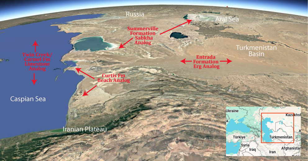
Modern Analog to Utah’s Middle Jurassic
.
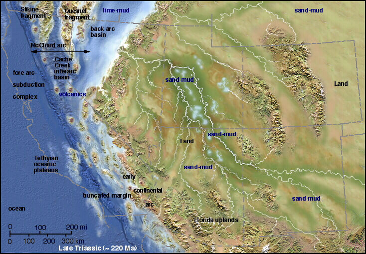
Paleogeography or Depiction of Utah during Middle Jurassic
What is the Grand Staircase?
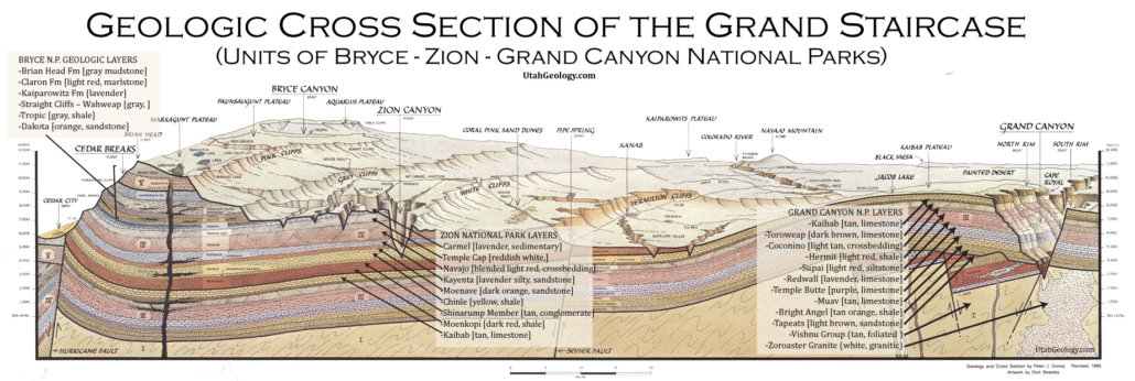
The Grand Staircase is a unique and extensive exposure of Earth’s history, showcasing over 200 million years of sedimentary rock layers. Geologists often liken these layers to a “book,” allowing for a detailed study of the Earth’s past, including changes in climate and environment.
The major sedimentary rock units exposed in the Grand Canyon range in age from 200 million to 600 million years and were deposited in warm shallow seas and near-shore environments. The nearly 40 identified rock layers of Grand Canyon form one of the most studied geologic columns in the world.

[flickr_tags user_id=”95435349@N04″ randomize=”true” margins=”4″ pagination=”numbers” tags=”navajo” max_num_photos=”9″]
[flickr_tags user_id=”95435349@N04″ tags=”chinle, navajo”]