Tag Archive for: formations

Supai & Hermosa Group / Weber Sandstone (Geology of The Grand Staircase)
Explore unit thickness in All-in-One App

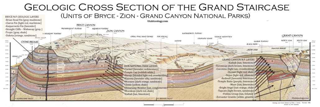
Grand Staircase Strat Column (Link).

Exposure:

The Supai Group is seen throughout the Grand Canyon. Moving northward it transitions into the Hermosa Group and can be Seen in the Goosenecks area and especially in Canyonlands. Farther north, the time equivalent Weber Sandstone of the Vernal area is particularly notable.

Age:  Early Permian, 315-285 million years ago.

Depositional Environment: deposited in a nearshore eolian, or wind-blown, environment. Specifically, it formed along the western edge of the ancient Pangaean Supercontinent. The Hermit Shale, which sits above the Esplanade, was deposited in a fluvial and coastal plain environment. The Esplanade Sandstone is part of the Supai Group, which generally represents a diverse range of environments, but eolian sands are most prevalent.

Paleogeography: Like most Grand Canyon units, the region was likely the western coast of the North American craton during much of the Paleozoic.

Tectonics: The collision of the Gondwana Plate with the North American Plate resulted in the Uncompahgre highland and thick deposits of the Paradox Basin of this age.

Climate: probably dry, but also likely prone to wide temperature swings associated with Karoo Glaciation of South Africa, Antarctica & South America (Gondwana).

Features: The Supai Group in the Grand Canyon is notable for its interbedded reddish shales, buff or pinkish buff sandstones, and gray limestones. It forms a prominent red staircase on the canyon walls, below the Hermit Shale and above the Redwall Limestone. The Supai Group also contains fossils, including fern-like leaves, reptile tracks, and various marine life.

Prominent Cliffs and Stepping Stones: The resistant sandstones within the Supai Group have eroded into thick, massive beds that form prominent, vertical cliffs. The overall effect of the interbedded rocks is a series of red staircases descending from the higher layers.

Fossils: Fossils are found in these layers, including fern-like leaves, reptile tracks, and various marine fossils like brachiopods, trilobites, seaweed, and sponges.
Geological Context:
.
The Supai Group was deposited in a variety of environments, including coastal lowlands, arid coasts, and rivers/swamps.

View looking north from Tuweap area near Toroweap Point.

Description:

The Supai Group consists of alternatingly interbedded soft, reddish shales and sandy; hard, buff or pinkish buff sandstones; and, in its lower part, hard, gray limestones. Most the sandstone consist of thick, massive beds that erode as prominent, vertical cliffs. The limestones also erode to form erode as prominent, vertical cliffs. The beds of shale and laminated sandstone weather as slopes. The alternation of hard and soft beds form a distinct step-like profile, which consists of alternating cliffs and slopes. The Supai Group overlies either the Redwall Limestone or Surprise canyon Formation and underlies the Hermit Formation.

This topographic profile of the Supai Group is consistent enough that it was initially divided into five subdivisions based upon the cliff versus its slope-forming character and, thus, indirectly on associated lithology within the Grand Canyon region. They are the (1.) Upper cliff unit, locally includes a receding ledge unit (Esplanade cliff); (2.) Upper slope unit; (3.) Middle cliff unit; (4.) Middle slope unit; (5.) Lower cliff and slope unit. These units can be traced throughout the Grand Canyon as they differ remarkably little from one end to the other. However, westward, the slope units do become less conspicuous. In particular, the middle slope unit becomes so weakly developed in the western Grand Cayon region, that the lower and middle cliff units seem to merge together such that lower and middle cliff units appear to merge together.

In 1975, McKee incorporated specific key beds, fauna zones, and erosion surfaces into the above topographic units to define the Watahomigi formation, Manakacha formation, Wescogame Formations and Esplanade Sandstone. Most important to defining and mapping these formations are three key beds, in addition to the basal conglomerate underlying the Redwall Limestone and Surprise canyon Formation, consisting of widespread, lithologically distinct, conglomerates. Two of these of conglomerates are associated with marked erosional surfaces and, thus, likely represent regional unconformities. Marine fossils that occur above and below. these conglomerates also indicate that represent significant periods of nondeposition and erosion.

The deposits of the Supai Group accumulated during multiple transgressive-regressive cycles associted with major sea level fluctuations reflecting changes in the volume of continetal ice sheets resulting from glacial – interglacial cycles. As a result of significant chnages in eustatic sea level locally modulated by local subsidence or uplift. As sea level fluctulated, fluvial, eolian, tidal, and shallow marine environments associated with a broad coastal plain shifted back and forth across the Grand Canyon area resulting in the cyclic deposition red beds, eolian sandstones, and marine limestones. Limestone beds represent the shallow marine limestone deposited during highstands of sea levels during maximum transgression. Unconformities characterized by paleovalleys and erosion surfaces covered with conglomerates represent lowstands of sea level during which river eroded deeply into coastal plains. The cyclic deposition of these sediments began with latest Mississippian and continued through the Pennsylvanian

Modern Analog to Utah’s Middle Jurassic
Trade this out with the Indus Delta!

.

Paleogeography or Depiction of Utah during Middle Jurassic

What is the Grand Staircase?

The Grand Staircase is a unique and extensive exposure of Earth’s history, showcasing over 200 million years of sedimentary rock layers. Geologists often liken these layers to a “book,” allowing for a detailed study of the Earth’s past, including changes in climate and environment.

The major sedimentary rock units exposed in the Grand Canyon range in age from 200 million to 600 million years and were deposited in warm shallow seas and near-shore environments. The nearly 40 identified rock layers of Grand Canyon form one of the most studied geologic columns in the world.

No photos No photos

Esplanade Sandstone & Cutler Cedar Mesa Sandstone (Geology of The Grand Canyon)

Explore unit thickness in All-in-One App

Grand Staircase Strat Column (Link).

Exposure:

The Esplanade Sandstone is the upper member of the Supai Group and forms a prominent bench visible throughout the Grand Canyon. It is time equivalent to the upper Culter Group units, the Cedar Mesa & Elephant Canyon Formations.

Age:  Early Permian, 290–294 million years ago.

Depositional Environment: deposited in a nearshore eolian, or wind-blown, environment. Specifically, it formed along the western edge of the ancient Pangaean Supercontinent. The Hermit Shale, which sits above the Esplanade, was deposited in a fluvial and coastal plain environment. The Esplanade Sandstone is part of the Supai Group, which generally represents a diverse range of environments, but eolian sands are most prevalent.

Paleogeography: Like most Grand Canyon units, the region was likely the western coast of the North American craton during much of the Paleozoic.

Tectonics: The collision of the Gondwana Plate with the North American Plate resulted in the Uncompahgre highland.

Climate: generally dry, with eolian (wind-blown) environments prevalent

Features: The Esplanade/Cedar Mesa Sandstones are a significant feature of the Grand Canyon & Canyonlands, forming a prominent shelf or terrace about a fourth of the way down from the rim. It’s a resistant sandstone, dark red in color, and plays a crucial role in the canyon’s landscape. This rock unit is a key element in creating a “canyon within a canyon” effect, as the Hermit Formation overlies it, forming the slopes below.

The Esplanade Sandstone is characterized by its cliff-forming nature and resistance to erosion, leading to its distinctive shelf formation. It’s also notable for its origin, formed from desert sand dunes that were subsequently compacted and cemented over long geological timescales. This formation also supports a unique ecosystem, with cyanobacteria, lichens, and mosses thriving on its surface, contributing to the overall biodiversity of the canyon.

The Esplanade Sandstone’s presence is particularly visible at locations like Toroweap Overlook and the east side of the canyon. The Esplanade Route trail, named after the sandstone, further highlights its prominence in the canyon’s landscape. Its resistant nature and distinctive color make it a visually striking and geologically important part of the Grand Canyon’s features.

Similarly, the Cedar Mesa forms a prominent shelf of the Hite region and may be lithologically equivalent as well as time equivalent (research this).

View looking north from Tuweap area near Toroweap Point.
Detailed schematic of the units of the Culter formation. (see full poster at this link).

Description:

The Lower Permian Esplanade Sandstone is a cliff-forming, resistant sandstone, dark red, geologic unit found in the Grand Canyon. The rock unit forms a resistant shelf in the west Grand Canyon, south side of the Colorado River, at the east of the Toroweap Fault, down-dropped to west, southeast of Toroweap Overlook (North Rim, at Lava Falls), and west of Havasupai. The red, sandstone shelf, The Esplanade is about 20-mi long. At Toroweap Overlook region, Toroweap Valley with Vulcan’s ThroneUinkaret volcanic field, the resistant Esplanade Sandstone is described in access routes exploring the Toroweap Lake area (Hike 17, Vulcans Throne).[2]

The Esplanade Route–(trail), of the east Grand Canyon is also named for the Esplanade Sandstone. The coeval sandstone geologic unit from eastern Utah is the Cedar Mesa Sandstone

The Supai Group members were created from marine (oceanic) sequences of marine transgression, and regression, thus the alternating sandstone, siltstones, conglomerate subsections (facies); the subsections are not always a continuous transition into the above section, mostly due to ocean levels, falling, or rising, glaciation, or regional subsidence–(basins, etc.) or uplift of land. Today’s Wasatch Front is the approximate lineage, NNE to SSW of the western coast region of North America from where the oceans transgressed. The ancient Antler Mountains–(Antler orogeny, off-shore volcanic island arch(es)), of ancient Nevada supplied material, from the west, off the ‘ancestral’ West Coast. The continent supplied material from the east, both directions supplying the offshore basin, the Cordilleran Basin which became part of the Basin and Range Province, in later epochs. Three other basins were involved in this history: southwest of the Ancestral Rocky Mountains was the Paradox Basin–(eastern Utah to Southwest Colorado), northeast was the Central Colorado Basin–(NW Colorado, NE Utah, SW Wyoming); the Oquirrh Basin was north-northwest, at present day northwest Utah.

Modern Analog to Utah’s Middle Jurassic

Trade this out with the Indus Delta!

.

Paleogeography or Depiction of Utah during Middle Jurassic

What is the Grand Staircase?

The Grand Staircase is a unique and extensive exposure of Earth’s history, showcasing over 200 million years of sedimentary rock layers. Geologists often liken these layers to a “book,” allowing for a detailed study of the Earth’s past, including changes in climate and environment.

The major sedimentary rock units exposed in the Grand Canyon range in age from 200 million to 600 million years and were deposited in warm shallow seas and near-shore environments. The nearly 40 identified rock layers of Grand Canyon form one of the most studied geologic columns in the world.

No photos No photos

Hermit/Organ Rock (Geology of The Grand Canyon)

Explore unit thickness in All-in-One App

Grand Staircase Strat Column (Link).

Exposure:

The Toroweap & White Rim Sandtones are best seen in Southern Utah and Northern Arizona.

Age:  Early Permian, 280 million years ago.

Depositional Environment: Coastal dune field (eolian with some marine transgressions). Marine transgressions, terrestrial wind-blown sand, coastal environments laid down the Kaibab, Toroweap, and Coconino formations. At different time, the marine waters came from the west, and receded and re-transgressed. The Coconino Formation represents a regional subaerial sea of sand that existed during a major regression. The Toroweap Formation represents a major marine transgression into the Grand canyon area during which red beds of the Seligman Member accumulated in supratidal, tidal, and terrestrial coastal plain environments. The overlying limestones of the Brady Canyon Member accumulated in open and brackish-water environments during the maximum extent of the marine transgression. A brief regression buried the sediments of the Brady Canyon Member under additional supratidal, tidal, and terrestrial coastal plain red beds of the Woods Ranch Member. The two members of the overlying Kiabab Limestone represent two additional major marine transgression into the Grand Canyon region.

Paleogeography: Sediment deposition was affected by the Uncompahgre uplift , but by the end of the Permian the Uncompahgre mountains had been worn down and was not longer a major sediment source.

Tectonics: The collision of the Gondwana Plate with the North American Plate resulted in the Uncompahgre highland.

Climate: Warm current winds

Features: The White Rim Sandstone is the upper member of the Permian Cutler Croup of rocks.  The White Rim Sandstone gets its name from the white color that is due to bleaching from hydrocarbons (organic compounds). This formation often creates a white band found along canyon rims where it is often relatively thin. The White Rim Sandstone is a cliff-forming formation consisting of fine- to coarse-grained sandstone (Condon, 1997).  This sandstone commonly displays large scale, high-angle cross-beds (dipping sediment layers) deposited by wind blown dunes. The thickness of this formation ranges from 5 to 75 feet thick (Morris, 2003).  The depositional environment that this was deposited in was a coastal dune field that was intermittently flooded by marine water resulting is some reworking of sediments (Komola and Chan, 1988).  The White Rim Sandstone can be viewed from the Goosenecks Overlook at the bottom of Sulphur Creek Canyon in Capitol Reef National Park.

Upper Permian equivalent layers in the Moab/Canyonlands region.
Note that the Moenkopi/Chinle sit uncomformably on the DeChelly (Coconino eqv.)
White Rim SS in Canyonlands National Park. Chinle seen in upper background.
The White Rim forms a cap rock in many parts of the state.
Detailed schematic of the units of the Culter formation. (see full poster at this link).

Description:

The White Rim Sandstone is a sandstone geologic formation located in southeastern Utah. It is the last member of the Permian Cutler Group, and overlies the major Organ Rock Formation and Cedar Mesa Sandstone; and again overlies thinner units of the Elephant Canyon and Halgaito Formations.

The White Rim is eponymous, as the sandstone is named for its prominent white color, and forms the rims of cliffs.

It is the continental geologic formation deposited at the time of marine transgressions during the Early to Middle Permian Period.

The coeval Toroweap Formation was laid down under marine conditions along the southwest margin of the North American continent and is found in northwest Arizona layered between Coconino Sandstone and the Kaibab Formation. The Toroweap is mostly from the Grand Canyon and just eastwards to Lee’s Ferry-(Colorado River, Grand Canyon), south to the Verde Valley region (Sedona, Sycamore Canyon, Oak Creek Canyon), but the Toroweap also occurs within sections in southeast Utah, and also became overlain by the Kaibab Formation, specifically at the Circle Cliffs, west of the Waterpocket Fold.

Toroweap Description:

The Toroweap Formation exhibits well-defined lateral and vertical changes in facies over its outcrop. In the western extent of its outcrop in the Grand Canyon region and adjacent parts of Utah and Nevada, the Toroweap Formation is readily subdivided, in ascending order, into the Seligman, Brady Canyon, and Woods Ranch members. Two of these members (Seligman and Woods Ranch members ) consist of red beds and evaporites (gypsum) and are separated by a fossiliferous limestone member (Brady Canyon Member). The red beds of the Seligman and Woods Ranch members are largely of soft, friable sediments, which rapidly weather into slopes, The Brady Canyon Member is a resistant limestone which characteristically stands up as a prominent cliff between the slopes of the Seligman and Woods Ranch members. Further eastward, the Brady Canyon Member disappears, and the two red bed members merged together into an undivided Toroweap Formation. Further east, the red beds grade laterally into cross-bedded sandstones of the Sand Cave Member of the Coconino Sandstone.[4][9][10]

The Seligman Member of the Toroweap formation largely consists of fine-grained, red and yellow sandstone. It typically exhibits flat or irregular bedding. Its maximum observed thickness is about 50 ft (15 m) and in most places is no thicker than 45 ft (14 m). At its upper contact, the Seligman Member grades upwards through a transitional zone of alternating beds of sandstone and limestone into the fossiliferous limestone of the Brady Canyon Member. In Grand Wash Canyon on Lake Mead, the sandstones of the Seligman Member contain a very conspicuous layer of breccia, interpreted to be an intraformational conglomerate, only a few feet above the top of the Coconino Sandstone. The basal layer of the Seligman Member is a red sandstone or siltstone composed of Coconino-like quartz grains scattered through finer-grained sediment. The Seligman Member interfingers with and lies conformably on the underlying Coconino Sandstone.[3][4][10]

Overlying the Seligman Member is the Brady Canyon Member. It consists of cliff-forming limestone and dolomite. Laterally, the Brady Canyon Member is divisible into two facies grading from one through a third transitional facies into the other using differences in lithology and fossil content. The first facies is exposed in an area from the extreme western edge of its outcrop belt east to Toroweap Valley and southeast almost to Seligman, Arizona. This facies consists of a marine limestone that is mostly coarsely crystalline and cherty in some beds. This facies contains a fauna dominated by brachiopods and echinoids. The second facies of the Brady Canyon Member is exposed in outcrops eastward past Seligman, Arizona to where it merges and terminates within the enclosing red beds. In consist of fine-grained, mostly sand-, silt-, and clay-free limestone. It contains a fauna composed almost exclusively of abundant, but poorly preserved, pelecypods and gastropods. It apparently accumulated nearer the coastline and likely under brackish-water conditions. The transition zone between the two facies consists of an unfossiliferous, thin-bedded (1 to 2 in (2.5 to 5.1 cm) thick), uniform-textured dolomite. This limestone weathers into smooth, small, angular cobbles. In western Grand Canyon region, it is thickest, as much as to 280 ft (85 m) thick. The Brady Canyon Member thins uniformly to the east where it is of approximately 220 ft (67 m) thick in the type section in Toroweap Valley and disappears near Marble Canyon as it merges with the overlying Woods Ranch Member. Beds of the third (dolomite) facies recur between overlying red beds of the Woods Ranch Member and the other facies of the Brady Canyon Member as part of a gradational contact between these members. Below Desert View Point in Grand Canyon, the Brady Canyon Member is about 20 ft (6.1 m) thick and is entirely missing in outcrops along the Little Colorado Canyon and in Sycamore Canyon.[3][4][10]

The red beds of the Woods Ranch Member consist of interbedded layers of gypsum, thin-bedded dolomite, and sandstone. Eastward of Havasu Canyon this member lack gypsum and dolomite and contains beds of white, cross-bedded sandstone. Breccias or intraformational conglomerates occur in many places throughout the entire outcrop of the Woods Ranch Member. Associated with these breccias in some places are lacustrine travertines. A prominent feature found throughout the entire outcrop of the Woods Ranch Member is a fossil-bearing limestone, It occurs over a remarkably wide area without appreciable variation with a thickness of only 3 to 4 ft (0.91 to 1.22 m). The fossils found everywhere in with this marker bed consist only of a pelecypod of the genus Schizodus. This member forms distinctive slopes and attains a maximum thickness of about 180 ft (55 m).

Modern Analog to Utah’s Middle Jurassic

Trade this out with the Indus Delta!

.

Paleogeography or Depiction of Utah during Middle Jurassic

What is the Grand Staircase?

The Grand Staircase is a unique and extensive exposure of Earth’s history, showcasing over 200 million years of sedimentary rock layers. Geologists often liken these layers to a “book,” allowing for a detailed study of the Earth’s past, including changes in climate and environment.

The major sedimentary rock units exposed in the Grand Canyon range in age from 200 million to 600 million years and were deposited in warm shallow seas and near-shore environments. The nearly 40 identified rock layers of Grand Canyon form one of the most studied geologic columns in the world.

No photos No photos

Toroweap/Coconino/White Rim Sandstone (Geology of The Grand Canyon)

Explore unit thickness in All-in-One App

Grand Staircase Strat Column (Link).

Exposure:

The Toroweap & White Rim Sandtones are best seen in Southern Utah and Northern Arizona.

Age:  Early Permian, 280 million years ago.

Depositional Environment: Coastal dune field (eolian with some marine transgressions). Marine transgressions, terrestrial wind-blown sand, coastal environments laid down the Kaibab, Toroweap, and Coconino formations. At different time, the marine waters came from the west, and receded and re-transgressed. The Coconino Formation represents a regional subaerial sea of sand that existed during a major regression. The Toroweap Formation represents a major marine transgression into the Grand canyon area during which red beds of the Seligman Member accumulated in supratidal, tidal, and terrestrial coastal plain environments. The overlying limestones of the Brady Canyon Member accumulated in open and brackish-water environments during the maximum extent of the marine transgression. A brief regression buried the sediments of the Brady Canyon Member under additional supratidal, tidal, and terrestrial coastal plain red beds of the Woods Ranch Member. The two members of the overlying Kiabab Limestone represent two additional major marine transgression into the Grand Canyon region.

Paleogeography: Sediment deposition was affected by the Uncompahgre uplift , but by the end of the Permian the Uncompahgre mountains had been worn down and was not longer a major sediment source.

Tectonics: The collision of the Gondwana Plate with the North American Plate resulted in the Uncompahgre highland.

Climate: Warm current winds

Features: The White Rim Sandstone is the upper member of the Permian Cutler Croup of rocks.  The White Rim Sandstone gets its name from the white color that is due to bleaching from hydrocarbons (organic compounds). This formation often creates a white band found along canyon rims where it is often relatively thin. The White Rim Sandstone is a cliff-forming formation consisting of fine- to coarse-grained sandstone (Condon, 1997).  This sandstone commonly displays large scale, high-angle cross-beds (dipping sediment layers) deposited by wind blown dunes. The thickness of this formation ranges from 5 to 75 feet thick (Morris, 2003).  The depositional environment that this was deposited in was a coastal dune field that was intermittently flooded by marine water resulting is some reworking of sediments (Komola and Chan, 1988).  The White Rim Sandstone can be viewed from the Goosenecks Overlook at the bottom of Sulphur Creek Canyon in Capitol Reef National Park.

Upper Permian equivalent layers in the Moab/Canyonlands region.
White Rim SS in Canyonlands National Park. Chinle seen in upper background.
The White Rim forms a cap rock in many parts of the state.
Detailed schematic of the units of the Culter formation. (see full poster at this link).

Description:

The White Rim Sandstone is a sandstone geologic formation located in southeastern Utah. It is the last member of the Permian Cutler Group, and overlies the major Organ Rock Formation and Cedar Mesa Sandstone; and again overlies thinner units of the Elephant Canyon and Halgaito Formations.

The White Rim is eponymous, as the sandstone is named for its prominent white color, and forms the rims of cliffs.

It is the continental geologic formation deposited at the time of marine transgressions during the Early to Middle Permian Period.

The coeval Toroweap Formation was laid down under marine conditions along the southwest margin of the North American continent and is found in northwest Arizona layered between Coconino Sandstone and the Kaibab Formation. The Toroweap is mostly from the Grand Canyon and just eastwards to Lee’s Ferry-(Colorado River, Grand Canyon), south to the Verde Valley region (Sedona, Sycamore Canyon, Oak Creek Canyon), but the Toroweap also occurs within sections in southeast Utah, and also became overlain by the Kaibab Formation, specifically at the Circle Cliffs, west of the Waterpocket Fold.

Toroweap Description:

The Toroweap Formation exhibits well-defined lateral and vertical changes in facies over its outcrop. In the western extent of its outcrop in the Grand Canyon region and adjacent parts of Utah and Nevada, the Toroweap Formation is readily subdivided, in ascending order, into the Seligman, Brady Canyon, and Woods Ranch members. Two of these members (Seligman and Woods Ranch members ) consist of red beds and evaporites (gypsum) and are separated by a fossiliferous limestone member (Brady Canyon Member). The red beds of the Seligman and Woods Ranch members are largely of soft, friable sediments, which rapidly weather into slopes, The Brady Canyon Member is a resistant limestone which characteristically stands up as a prominent cliff between the slopes of the Seligman and Woods Ranch members. Further eastward, the Brady Canyon Member disappears, and the two red bed members merged together into an undivided Toroweap Formation. Further east, the red beds grade laterally into cross-bedded sandstones of the Sand Cave Member of the Coconino Sandstone.[4][9][10]

The Seligman Member of the Toroweap formation largely consists of fine-grained, red and yellow sandstone. It typically exhibits flat or irregular bedding. Its maximum observed thickness is about 50 ft (15 m) and in most places is no thicker than 45 ft (14 m). At its upper contact, the Seligman Member grades upwards through a transitional zone of alternating beds of sandstone and limestone into the fossiliferous limestone of the Brady Canyon Member. In Grand Wash Canyon on Lake Mead, the sandstones of the Seligman Member contain a very conspicuous layer of breccia, interpreted to be an intraformational conglomerate, only a few feet above the top of the Coconino Sandstone. The basal layer of the Seligman Member is a red sandstone or siltstone composed of Coconino-like quartz grains scattered through finer-grained sediment. The Seligman Member interfingers with and lies conformably on the underlying Coconino Sandstone.[3][4][10]

Overlying the Seligman Member is the Brady Canyon Member. It consists of cliff-forming limestone and dolomite. Laterally, the Brady Canyon Member is divisible into two facies grading from one through a third transitional facies into the other using differences in lithology and fossil content. The first facies is exposed in an area from the extreme western edge of its outcrop belt east to Toroweap Valley and southeast almost to Seligman, Arizona. This facies consists of a marine limestone that is mostly coarsely crystalline and cherty in some beds. This facies contains a fauna dominated by brachiopods and echinoids. The second facies of the Brady Canyon Member is exposed in outcrops eastward past Seligman, Arizona to where it merges and terminates within the enclosing red beds. In consist of fine-grained, mostly sand-, silt-, and clay-free limestone. It contains a fauna composed almost exclusively of abundant, but poorly preserved, pelecypods and gastropods. It apparently accumulated nearer the coastline and likely under brackish-water conditions. The transition zone between the two facies consists of an unfossiliferous, thin-bedded (1 to 2 in (2.5 to 5.1 cm) thick), uniform-textured dolomite. This limestone weathers into smooth, small, angular cobbles. In western Grand Canyon region, it is thickest, as much as to 280 ft (85 m) thick. The Brady Canyon Member thins uniformly to the east where it is of approximately 220 ft (67 m) thick in the type section in Toroweap Valley and disappears near Marble Canyon as it merges with the overlying Woods Ranch Member. Beds of the third (dolomite) facies recur between overlying red beds of the Woods Ranch Member and the other facies of the Brady Canyon Member as part of a gradational contact between these members. Below Desert View Point in Grand Canyon, the Brady Canyon Member is about 20 ft (6.1 m) thick and is entirely missing in outcrops along the Little Colorado Canyon and in Sycamore Canyon.[3][4][10]

The red beds of the Woods Ranch Member consist of interbedded layers of gypsum, thin-bedded dolomite, and sandstone. Eastward of Havasu Canyon this member lack gypsum and dolomite and contains beds of white, cross-bedded sandstone. Breccias or intraformational conglomerates occur in many places throughout the entire outcrop of the Woods Ranch Member. Associated with these breccias in some places are lacustrine travertines. A prominent feature found throughout the entire outcrop of the Woods Ranch Member is a fossil-bearing limestone, It occurs over a remarkably wide area without appreciable variation with a thickness of only 3 to 4 ft (0.91 to 1.22 m). The fossils found everywhere in with this marker bed consist only of a pelecypod of the genus Schizodus. This member forms distinctive slopes and attains a maximum thickness of about 180 ft (55 m).

Modern Analog to Utah’s Middle Jurassic

Trade this out with the Indus Delta!

.

Paleogeography or Depiction of Utah during Middle Jurassic

What is the Grand Staircase?

The Grand Staircase is a unique and extensive exposure of Earth’s history, showcasing over 200 million years of sedimentary rock layers. Geologists often liken these layers to a “book,” allowing for a detailed study of the Earth’s past, including changes in climate and environment.

The major sedimentary rock units exposed in the Grand Canyon range in age from 200 million to 600 million years and were deposited in warm shallow seas and near-shore environments. The nearly 40 identified rock layers of Grand Canyon form one of the most studied geologic columns in the world.

Trackways in the Coconino Sandstone, Grand Canyon.

No photos No photos

Kaibab Limestone (Geology of The Grand Staircase)

Explore unit thickness in All-in-One App

Grand Staircase Strat Column (Link).

Exposure:

The Kaibab Limestone forms the caprock of most of the Grand Canyon. Great exposures exist west of Zion National Park.

Age:  Early Permian, 250 million years ago.

Depositional Environment: Shallow Marine Shelf Deposit.

Paleogeography: Sediment deposition was influenced by the Uncompahgre Uplift (ancestral Rocky Mountains), but by the end of the Permian, the Uncompahgre mountains had been worn down and was not longer a major sediment source.

Tectonics: Collision of the Gondwana Plate with the Northern Plate resulted in the Uncompahgre highland.

Climate: Warm current winds

Features: The Kaibab Limestone is composed of impure cherty limestone and dolomite that interfinger with the White Rim Sandstone below it (Mathis, 2000).  The Kaibab rocks range in color from gray, buff, and brown,  to yellow/brown dolomite. Some sandy, carbonate beds are very fossiliferous (Condon, 1997).   Invertebrate fossils include brachiopods, pelecypods, gastropods, crinoids, and bryozoans. The Kaibab formation in Capitol Reef National Park is only 0-200’ thick and but thickens to 300-500’ in the Grand Canyon (Morris, 2003).  The difference in thickness is attributed to erosion. The environmental setting for the Kaibab Limestone was a shallow marine shelf deposit that represents the time of maximum eastward transgression of  the Kaibab Sea (Condon, 1997).  The Kaibab Sea began to withdraw by the Middle Permian, which left these sediments exposed to be subject to erosion (Condon, 1997).  The Kaibab Limestone is visible at the Goosenecks Overlook in Capitol Reef National Park.

Closeup view of Kaibab Limestone on the south rim of the Grand Canyon. Note that the layer has more sandy/silty horizons in this region than in other regions.
Kaibab forms the topmost or caprock of the Grand Canyon.

Description:

The Kaibab Limestone is a complex sedimentary package of interbedded and interfingering gypsum, limestone, dolomite, chert, siltstone, and sandstone that is 300–400 ft (91–122 m) thick. Erosion-resistant layers of limestone and dolomite form steep cliffs and the rims of the Grand Canyon and its tributary canyons. They also underlie most of the expansive surface of the Kaibab Plateau surrounding the Grand Canyon. Less erosion-resistant sandstones, siltstones, and cherts form distinct recesses along cliff faces.

As previously noted, the Kaibab Limestone is currently subdivided into two members, the Fossil Mountain Member and the underlying Harrisburg Member, in the Grand Canyon area. Eastward, both members become more sandy, silty, and clayey at the expense of limestone, dolomite, and chert, until both members consist uniformly of interbedded and interfingering sandstone, sandy limestone, and sandy dolomite that that cannot be subdivided into individual members.

The Fossil Mountain Member consists largely of light gray, cherty, thick-bedded limestone. It is named for its type locality at Fossil Mountain, which lies just east of the Bass Trail in Grand Canyon National Park, Arizona. The Fossil Mountain Member forms a continuous and promimemt cliff overlying the slope-forming Woods Ranch Member of the Toroweap Formation. The distribution of chert is argued to reflect the original occurrence and abundance of siliceous sponges and accumulation of their spicules. In the western part of the Grand Canyon region, it consists predominately of fossiliferous limestone. Eastward, it grades eastward into nondescript sandstone, sandy carbonate, and dolomite and thins from approximately 250–300 ft (76–91 m) thick to about 200 ft (61 m) thick at Fossil Mountain along the south rim.

The Harrisburg Member, formerly known as either the alpha or Harrisburg gypsiferous member, consists of interbedded light-red to pale-gray limestone and dolomite, siltstone, sandstone, and gypsum. These strata form a sloping surface with projecting ledges of limestone and dolomite. It is named for exposures at Harrisburg Dome, its type locality in southwestern Utah. The Harrisburg Member is about 160–300 ft (49–91 m) thick. East of a line running roughly north-south from near Page to east and south of Flagstaff, the Harrisburg Member grades into calcareous sandstone and becomes in separatable from overlying Fossil Mountain Member. East of that line, the Kaibab Limestone is known as the Kaibab Formation.

The Big Maria and Little Maria mountains in Riverside County, California expose strongly deformed and overturned metasedimentary strata. These cratonic metasedimentary rocks stratigraphically correlate with Paleozoic and Mesozoic strata exposed in the Grand Canyon region. They have been highly metamorphosed to upper middle to upper greenschist grade. These metasedimentary strata are preserved as roof pendants surrounded by Late Cretaceous dioritic and granitic plutons. The uppermost Paleozoic metasedimentary strata in the Big Maria region have been designated and mapped as the Kaibab Marble. It consists of calcitic and subordinate dolomitic marbles, metachert, quartzite, and minor anhydrite schist. The Kaibab Marble shows a variety of colors including white, gray, buff, yellow, pink, and brown. Commonly, these colors are striped by dark-weathering metachert. Exposures of the Kaibab Marble typically exhibits spectacular isoclinal folds, recumbent folds, and disrupted structures on all scales. Because of tectonic deformation, it ranges in thickness from 2–300 ft (0.61–91.44 m). It Likley consists of metamorphised, undifferentiated limestones and dolomites of both the Toroweap Formation and Kaibab Limestone.

Modern Analog to Utah’s Middle Jurassic

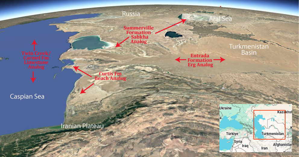
Many modern analogs have been proposed for the desert ergs, sabkha’s and limestone’s of Utah’s Middle Jurassic, but we favor Africa & the Turkmenistan/Caspian Basin as it includes all the depositional environments found for this geologic period.

.

Paleogeography or Depiction of Utah during Middle Jurassic

What is the Grand Staircase?

The Grand Staircase is a unique and extensive exposure of Earth’s history, showcasing over 200 million years of sedimentary rock layers. Geologists often liken these layers to a “book,” allowing for a detailed study of the Earth’s past, including changes in climate and environment.

The major sedimentary rock units exposed in the Grand Canyon range in age from 200 million to 600 million years and were deposited in warm shallow seas and near-shore environments. The nearly 40 identified rock layers of Grand Canyon form one of the most studied geologic columns in the world.

No photos No photos

Moenkopi Formation (Geology of Utah’s Grand Staircase)

Explore unit thickness in All-in-One App

Grand Staircase Strat Column (Link).

Exposure:

The Moenkopi formation can be found throughout the Colorado Plateau. But its thickest extent stretches from southwest Utah to Northern Arizona.

Age:  Lower Triassic to possibly lower Middle Triassic

Depositional Environment: Tidal sabkha (also with nearshore shales, shallow marine limestones, and some floodplain)

Paleogeography: The Moenkopi Formation was deposited along the western portion of the United States

Tectonics: There was very little tectonic activity was occurring during the time of deposition.

Climate: During the initial deposition of the Moenkopi Formation, the climate was rather hot and dry, then during the later members (the Sinbad Limestone through the Moody Canyon Members) the climate progressively got wetter, but it was likely still arid (Blakey, 1973).

Features: The Moenkopi Formation preserves extensive ancient tidal and nearshore deposits. Continental conditions were located to the east, and marine conditions to the west. Four different members of the Moenkopi were deposited in the Capitol Reef region. The lowest Black Dragon Member was deposited under marine conditions preserving a shallowing upwards sequence, capped by beach sands and fluvial (river) deposits. Cyclic alternation of supratidal (above the ocean level) to subtidal (below ocean the level) deposits resulted in interbedded (alternating) mud and sand beds throughout much of the Moenkopi (Blakey, 1973).

Following the Black Dragon Member, the Sinbad Limestone Member was deposited under shallow marine conditions before clastic sedimentation resumed in the overlying Torrey Member. The final member, The Moody Canyon Member, was deposited under widespread, uniform, low-energy marine conditions, producing a generally “structure-less” mudstone (Blakey, 1973).

The Moenkopi Formation typically contains abundant thinly bedded mudstones and sandstones (Figures 2 and 3) with a large variety of ripple marks (Figures 4 and 5), and some trace fossils (impressions from animals in the sediment) (Figures 6 and 7).  Secondary gypsum veins cut through this formation (Figure 8 and 9).

Fault view to the left of Chimney Rock. The Shinarump Member on the left side of the photograph is downdropped compared to the right side. The blue dotted line indicates the inferred location of a normal fault.  The footwall is the Moenkopi Formation overlain by the Shinarump (right of photo) and the hanging wall is the Shinarump overlain by the Wingate (left of photo).
Complex ripples from a sandstone bed.
Gypsum veins running throughout the upper Moenkopi Formation directly underlying a Pleistocene Terrace.
The paleogeographic setting (Dubiel, 1994) shows the general tectonic elements of the Western Interior of Pangea.

Description:

The Moenkopi consists of thinly bedded sandstone, mudstone, and shale, with some limestone in the Capitol Reef area. It has a characteristic deep red color and tends to form slopes and benches. The depositional environment varies from fluvial channel and floodplain deposits in the eastern exposures to tidal mudflats in the Cedar Mesa area to deltaic sandstones and shallow marine limestones at Capitol Reef. In eastern Nevada and northwestern Utah, it thickens dramatically, then transitions to the Woodside, Thaynes, and Mahogany formations.

The general deposition setting was sluggish rivers traversing a flat, featureless coastal plain to the sea. The low relief meant that the shoreline moved great distances with changes of sea level or even with the tides. Thickness varies from a feather edge against the Uncompahgre highlands to the east to over 600 metres (2,000 ft) in southwestern Utah. The thickness varies greatly in the Paradox Basin, where the Moenkopi is thin to nonexistent on the crests of salt anticlines and over 400 meters (1,300 feet) thick in the corresponding synclines.

The Moenkopi rests unconformably on Paleozoic beds and the Chinle Formation in turn rests unconformably on the Moenkopi. Both unconformities are locally angular unconformities. The lower unconformity corresponds to the regional Tr-1 unconformity and the upper to the regional Tr-3 unconformity. The Tr-1 unconformity represents a hiatus of at least 20 million years while Tr-2 represents a hiatus of about 10 million years.

Members differ considerably from east to west, in part because sandstone beds corresponding to marine transgressions are used to define members to the west but cannot be traced to the east.

Modern Analog to Utah’s Middle Jurassic

Many modern analogs have been proposed for the desert ergs, sabkha’s and limestone’s of Utah’s Middle Jurassic, but we favor Africa & the Turkmenistan/Caspian Basin as it includes all the depositional environments found for this geologic period.

.

Paleogeography or Depiction of Utah during Middle Jurassic

What is the Grand Staircase?

The Grand Staircase is a unique and extensive exposure of Earth’s history, showcasing over 200 million years of sedimentary rock layers. Geologists often liken these layers to a “book,” allowing for a detailed study of the Earth’s past, including changes in climate and environment.

The major sedimentary rock units exposed in the Grand Canyon range in age from 200 million to 600 million years and were deposited in warm shallow seas and near-shore environments. The nearly 40 identified rock layers of Grand Canyon form one of the most studied geologic columns in the world.

No photos No photos

Chinle Formation (Geology of Utah’s Grand Staircase)

Explore unit thickness in All-in-One App

Grand Staircase Strat Column (Link).

Exposure:

The Chinle formation can be found throughout the Colorado Plateau. From the Flanks of the Uintas to Petrified Forest National Park in Arizona.

Age:  Late Triassic.

Depositional Environment: N
on-marine fluvial channels, floodplains, paleosols, marshes, and small lakes.

Paleogeography: The Chinle Formation was deposited during the Late Triassic when the supercontinent Pangea had landmass on both sides of the equator.  Utah lay at the paleolatitude of 15° N. On the western margin of the continent (the approximate location of California today) and in southern Arizona into Mexico, subduction complexes contributed the volcanic ash to the bentonitic beds in the Chinle Formation (Prochnow et al., 2006.) East of Utah, the Uncompahgre highlands was a sediment source for Chinle deposits. (Prochnow et al., 2006)

Tectonics: The basinal area (created by tectonism) was subsiding significantly enough to provide enough accommodation space to capture and accumulate eolian sediment (Kocurek and Dott 1983).

Climate: The beginning of Chinle deposition was dominated by wet environments such as stream systems, lakes, wetlands, and deltaic distributary channels. Eventually the climate shifted and dryer environments prevailed such as seasonal stream systems and floodplains. By the end of the Chinle time, eolian deposits (sand dunes) indicate arid conditions.

Features: Uranium-rich conglomeratic sandstones in the Shinarump Member.

This resistant basal unit is typically white, yellow, or gray in color.  Sandstone structures within this subfacies include lenticular internal scour surfaces, large trough cross beds, and some horizontal laminations. The sandstone grades laterally into siltstone and mudstone lenses which contain organic carbon fragments as well as carbonized plant fossils (Dubiel, 1987). The Shinarump Member is a coarse-grained conglomeratic sandstone that represents a widespread fluvial  channelbelt.

Colorful variegated mudstones and bentonitic sediments in the Monitor Butte Member are gentle slope formers of the characteristic Chinle “badlands”.

There is a gradational contact between the Shinarump and overlying Monitor Butte Member which is purple, yellow, and white mottled sandy siltstone and sandstone. This unit is known as the purple mottled unit (PMU), the color variations occur from different concentrations of iron bearing minerals (Dubiel, 1987). This unit contains lungfish burrows and represents a fluctuating water table which formed oxidizing and reducing environments which redistributed the iron in the sediments (Dubiel, 1987), along with fragments of plant material. The black mudstone has abundant conchostracans, fish scales, fragments of fish bone, and lenses of coal. This unit represents lacustrine marsh bog and wetland environments. Limestone, bentonitic sandstone, and siltstone occur above the coal units. Overall, the Monitor Butte Member was an extensive system of fluvial (stream) and deltaic distributary channels and splays, lacustrine (lake), prodelta and deltaic deposits (Dubiel, 1987).

Carbonized and Petrified Wood in the Monitor Butte Member.

Above the Moss Back Member, lavender and brown variegated mudstone and sandstone of the Petrified Forest Member (Dubiel, 1987 has bentonites (volcanic ashes), thin lenses of carbonate nodule conglomerate, and sandy units with large scale internal scour surfaces and large trough cross-stratification. Important fauna include abundant vertebrate remains, gastropods, lungfish tooth plates, and unionid thin shelled bivalves. This unit represents fluvial sandstone and floodplain mudstones and laterally restricted marsh mudstones. It was deposited by sinuous streams and had many avulsion (redirection of the stream) events.

The Petrified Forest Member interfingers with pink and green limestone and red to orange siltstone of the Owl Rock Member. The limestone has mottled coloration and contains lungfish burrows and ostracodes. This indicates lacustrine basins and lacustrine margin deposition (Dubiel, 1987).

Fault view to the left of Chimney Rock. The Shinarump Member on the left side of the photograph is downdropped compared to the right side. The blue dotted line indicates the inferred location of a normal fault.  The footwall is the Moenkopi Formation overlain by the Shinarump (right of photo) and the hanging wall is the Shinarump overlain by the Wingate (left of photo).
Two adits are mined into the Shinarump Member of the Chinle Formation. Black lines are the approximate contacts between the Moenkopi, Chinle, and Wingate Formations. The Chinle Formation is divided into the Shinarump Member, where the uranium mines are, and the overlying Monitor Butte, Petrified Forest and Owl Rock Members (lumped and not individually distinguished for labeling purposes).
The paleogeographic setting (Dubiel, 1994) shows the general tectonic elements of the Western Interior of Pangea.

Description:

The Chinle Formation is an Upper Triassic continental geological formation of fluvial, lacustrine, and palustrine to eolian deposits spread across the U.S. states of Nevada, Utah, northern Arizona, western New Mexico, and western Colorado. In New Mexico, it is often raised to the status of a geological group, the Chinle Group. Some authors have controversially considered the Chinle to be synonymous to the Dockum Group of eastern Colorado and New Mexico, western Texas, the Oklahoma panhandle, and southwestern Kansas. The Chinle Formation is part of the Colorado Plateau, Basin and Range, and the southern section of the Interior Plains.[1] A probable separate depositional basin within the Chinle is found in northwestern Colorado and northeastern Utah. The southern portion of the Chinle reaches a maximum thickness of a little over 520 meters (1,710 ft). Typically, the Chinle rests unconformably on the Moenkopi Formation.

The Chinle Formation was probably mostly deposited in the Norian stage, according to a plethora of chronological techniques. It is a thick and fossiliferous formation with numerous named members (subunits) throughout its area of deposition.

The Chinle continues northwards into southern Utah and the Four Corners area, though it thins greatly to the northwest. A narrow band of undifferentiated purplish sediments from the lower part of the formation extend into vicinity of St. George. The formation thickens eastward into Zion National Park and Grand Staircase–Escalante National Monument. The Chinle is a prominent component of badlands and outcrops in the various national parks, monuments, and recreation areas of southeast Utah, extending in a discontinuous patchwork up to the San Rafael Swell.[24][25] The stratigraphic nomenclature used in southern Utah is also utilized in Monument Valley, where the coarse-grained lower members of the Chinle form a caprock for many famous buttes which characterize the valley.[7]

In this region, the stratigraphically lowest unit in the Chinle is usually the Shinarump Conglomerate (or Shinarump Member), which thins northward but is a reliable component of outcrops throughout the region. In several areas, a thin layer of mottled paleosols, the Temple Mountain Member, may be superimposed onto the Shinarump and underlying Moenkopi Formation.[26][25][27]

The Monitor Butte Member overlies the Shinarump and Temple Mountain members in southeast Utah and Monument Valley. This unit comprises drab and generally fine-grained sediments, equivalent to the Blue Mesa Member and Bluewater Creek Formation found further south.[25] The facies of this interval have been interpreted as overbank (distal floodplain) and lacustrine deposits. At Zion National Park, the Monitor Butte Member is replaced by a thick time-equivalent unit, the Cameron Member, which is also found in the Navajo Nation near its namesake of Cameron, Arizona. The Cameron Member is practically identical to the Blue Mesa Member, and likely represents the same depositional environment along the ancient river system responsible for the Chinle Formation. It is also distinct from the Monitor Butte Member, which has more evaporite deposits and fewer red sandy layers.[11][25]

The drab mudstone of the Monitor Butte and Cameron members are succeeded in a few areas by a thin section of massive conglomeratic sandstone, the Moss Back Member. This member represents sandy river channel deposits and is likely equivalent to part of the Sonsela Member.[25] Elsewhere, the Monitor Butte grades into the Petrified Forest Member, which in Utah includes the thin but geographically extensive Correo Sandstone Bed. The Petrified Forest Member is followed by the Owl Rock Member.[25][9] A unit of drab interbedded coarse and fine sediments, the Kane Springs beds, develops in the Paradox Basin. The Kane Springs beds are river deposits which are likely equivalent to the Owl Rock Member and the upper part of the Petrified Forest Member.[25] Finally, either the Rock Point Member or Church Rock Member overlie the Owl Rock. Some researchers feel that the Church Rock and Rock Point members may be synonymous.[28] They are complex heterolithic units, representing variously braided-river facies, lacustrine, and overbank deposits.

Modern Analog to Utah’s Middle Jurassic

Many modern analogs have been proposed for the desert ergs, sabkha’s and limestone’s of Utah’s Middle Jurassic, but we favor Africa & the Turkmenistan/Caspian Basin as it includes all the depositional environments found for this geologic period.

.

Paleogeography or Depiction of Utah during Middle Jurassic

Paelogeography of the Triassic and Early Jurassic. Deposition of the Kayenta, Wingate/Moenave, Chinle & Moenkopi Formations in a prograding sequence. (Deltaic mountains extremely unlikely. Blakey, 2008)

What is the Grand Staircase?

The Grand Staircase is a unique and extensive exposure of Earth’s history, showcasing over 200 million years of sedimentary rock layers. Geologists often liken these layers to a “book,” allowing for a detailed study of the Earth’s past, including changes in climate and environment.

The major sedimentary rock units exposed in the Grand Canyon range in age from 200 million to 600 million years and were deposited in warm shallow seas and near-shore environments. The nearly 40 identified rock layers of Grand Canyon form one of the most studied geologic columns in the world.

No photos No photos

Wingate/Moenave Sandstone (Geology of Utah’s Grand Staircase)

Explore unit thickness in All-in-One App

Exposure:

The Wingate is exposed throughout the state of Utah, especially visible in Capital Reef and Glen Canyon NRA. In the Southwest corner it transitions into and interfingers with the Moenave Fm which has a strong lacustrine component.

Age:  Early Jurassic, The Wingate Sandstone is dated to the Earliest Jurassic, though precise dating of eolian deposits is typically difficult (see discussion in Navajo Sandstone). 

Depositional Environment: Eolian (wind blown)

The Wingate Sandstone was deposited in an eolian environment made up of large sand dunes, similar to portions of the modern Sahara Desert.  See Navajo Sandstone discussion for details that apply to the Wingate Sandstone as well.

Paleogeography:

The Wingate Sandstone erg (a large sand sea) originally lay at very low latitude, centered approximately 10o north of the equator. Like the Navajo Sandstone, its sediment source was at least partly from the Appalachian Mountains (Dickenson and Gehrels 2003).

Directly adjacent to the south and west of the erg lay the erg margin facies of the Moenave Formation (Blakey et al. 1988, Blakey 1989, 2008, Clemmensen et al. 1989) .

Tectonics: The basinal area (created by tectonism) was subsiding significantly enough to provide enough accommodation space to capture and accumulate eolian sediment (Kocurek and Dott 1983).

Climate: Dry /Arid. Similar to the Navajo Sandstone, the climate in the Colorado Plateau region during deposition of the Wingate sandstone would have been very dry, classified as hyper-arid (Kocurek and Dott 1983, Loope et al. 2004).

Features: The Wingate tends to from very blocky, vertical cliffs, likely related to different grain sizes and cementation compared to the younger (overlying) Navajo Sandstone. Because of the cliff weathering and smooth vertical faces, it is often difficult to see and access sedimentary structures in the Wingate Sandstone.  It contains large-scale cross stratification characteristic of dunes and shows internal grain fall, grain flow, and wind ripple strata.  Further, the desert varnish, iron oxide staining and weathering pattern of the Wingate Sandstone commonly obscures the trough cross stratification. 

Though it is hard to see elsewhere in the park because of the desert varnish, iron oxide staining, and weathering, the Wingate does have large-scale trough cross strata common to sand dunes.  These trough cross strata are visible when you can get very close to the rock, such as at the Petroglyphs stop.         
Since both the Wingate and Navajo Sandstones are eolian formations present in Capital Reef National Park, and are nearly adjacent formations with only the Kayenta formation separating them, it is important to be able to tell them apart.  This photo shows the Wingate in the midground with the Navajo in the center background, on the skyline, and is good for highlighting the differences between the two formations

Description:

Wingate Sandstone is particularly prominent in southeastern Utah, where it forms attractions in a number of national parks and monuments. These include Capitol Reef National Park, the San Rafael Swell, and Canyonlands National Park.

Wingate Sandstone frequently appears just below the Kayenta Formation and Navajo Sandstone, two other formations of the Glen Canyon group. Together, these three formations can result in immense vertical cliffs of 2,000 feet (610 meters) or more. Wingate layers are typically pale orange to red in color, the remnants of wind-born sand dunes deposited approximately 200 million years ago in the Late Triassic.

Long dated to the Early Jurassic only, fossils (including a phytosaur skull) and other evidence indicate that part of the Wingate Sandstone is as old as Late Triassic in age. The upper part of the formation, which laterally interfingers with the Moenave Formation to the west, is Early Jurassic in age

The Moenave was deposited on an erosion surface on the Chinle Formation following an early Jurassic uplift and unconformity that represents about ten million years of missing sedimentation. Periodic incursions of shallow seas from the north during the Jurassic flooded parts of Wyoming, Montana, and a northeast–southwest trending trough on the Utah/Idaho border. The Moenave was deposited in a variety of river, lake, and flood-plain environments, near the ancient Lake Dixie.

The oldest beds of this formation belong to the Dinosaur Canyon Member, a reddish, slope-forming rock layer with thin beds of siltstone that are interbedded with mudstone and fine sandstone.[4] The Dinosaur Canyon, with a local thickness of 140 to 375 feet (43 to 114 m), was probably laid down in slow-moving streams, ponds and large lakes. Evidence for this is in cross-bedding of the sediments and large numbers of fish fossils.

The upper member of the Moenave is the pale reddish-brown with a thickness of 75 to 150 feet (23 to 46 m) and cliff-forming Springdale Sandstone. It was deposited in swifter, larger, and more voluminous streams than the older Dinosaur Canyon Member. Fossils of large sturgeon-like freshwater fish have been found in the beds of the Springdale Sandstone. The next member in the Moenave Formation is the thin-bedded Whitmore Point, which is made of mudstone and shale. The lower red cliffs visible from the Zion Human History Museum (until 2000 the Zion Canyon Visitor Center) and the St. George Dinosaur Discovery Site, discovered on February 26, 2000, are accessible examples of this formation.

Modern Analog to Utah’s Middle Jurassic

Many modern analogs have been proposed for the desert ergs, sabkha’s and limestone’s of Utah’s Middle Jurassic, but we favor Africa & the Turkmenistan/Caspian Basin as it includes all the depositional environments found for this geologic period.

.

Paleogeography or Depiction of Utah during Middle Jurassic

Paelogeography of the Triassic and Early Jurassic. Deposition of the Kayenta, Wingate/Moenave, Chinle & Moenkopi Formations in a prograding sequence. (Deltaic mountains extremely unlikely. Blakey, 2008)

What is the Grand Staircase?

The Grand Staircase is a unique and extensive exposure of Earth’s history, showcasing over 200 million years of sedimentary rock layers. Geologists often liken these layers to a “book,” allowing for a detailed study of the Earth’s past, including changes in climate and environment.

The major sedimentary rock units exposed in the Grand Canyon range in age from 200 million to 600 million years and were deposited in warm shallow seas and near-shore environments. The nearly 40 identified rock layers of Grand Canyon form one of the most studied geologic columns in the world.

No photos No photos

Kayenta Formation (Geology of Utah’s Grand Staircase)

Explore unit thickness in All-in-One App

Exposure:

The Kayenta is exposed throughout the state of Utah, but is especially visible in Zion National Park, Capital Reef and Glen Canyon NRA.

Age:  Early Jurassic, 199.6 million years ago to 175.6 million years ago.

Depositional Environment: Fluvial (river) environment

The Navajo Sandstone was deposited in an eolian environment composed of large sand dunes, similar to portions of the modern Sahara Desert.  In an eolian environment there are two primary types of deposits: 1) dunes, typified by large-scale trough cross stratification; and  2) interdunes, which are the flat lying areas between dunes.

Paleogeography:

The Wingate erg was reworked by river currents in the time period when the Kayenta formation was being deposited.

Tectonics: The earliest uplift of the Navadaplano and Island arcs (Sierra Navadas) begin to create a rain shadow in early Jurassic (late Kayenta?) times.

Climate: Seasonal climate, rainy summers and dry winters

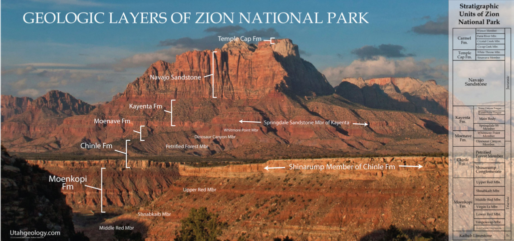
Features: The Kayenta Formation is Jurassic in age and makes up the middle third of the three-part section that make up the Glen Canyon Group.   The Wingate Sandstone is below the Kayenta, while the Navajo Sandstone is above it.  The Kayenta Formation is about 350 feet thick and range in color from red, to maroon, to brown (Mathis, 2000). 

 The Kayenta is composed of sandstones, siltstones, and conglomerates that interbed (or alternate) within each other (Bates et al., 1984).  At the top of the Kayenta, where it meets the Wingate, and the bottom of the Kayenta, where it meets Navajo, are contacts that are gradational (Mathis, 2000).  Due to this, sometimes it is challenging to differentiate between the Wingate and the Kayenta formations but there are some clues that might aid in discerning the two.  The Wingate Sandstone is eolian in origin meaning it was formed/deposited by the wind.  In contrast, the Kayenta formation represents a fluvial (pertaining to a river) environment (Bates et al., 1984).  According to Friz 1980, the rivers that formed the Kayenta were traveling in a westward to southwestward direction.  In the Kayenta, there are small cross-beds (layers of sediment that are tilted at an angle) in contrast to the Navajo and Wingate, which have large cross-beds (Morris et al., 2003).  Cross-beds that look like lenses (lenticular) often are indicative of the Kayenta.  The Wingate fractures vertically, while the Kayenta fractures horizontally.  This fracturing is readily apparent in “the castle” rock structure seen at the Visitors Center of the park (Figure 1).   The Kayenta usually weathers as low cliffs and ledges (Morris et al., 2003).

“The castle” rock structure is north of the Visitors Center of the park. The Wingate (upper light tan colored rock) fractures vertically, whereas the Kayenta (reddish brown, overlying the Wingate as shown to the far right of the Wingate in the background) breaks horizontally.

Description:

The red and mauve Kayenta siltstones and sandstones that form the slopes at base of the Navajo Sandstone cliffs record the record of low to moderate energy streams. Poole (1997) has shown that the streams still flowed toward the east depositing from 150 to 210 m (500 to 700 ft) of sediment here. The sedimentary structures showing the channel and flood plain deposits of streams are well exposed on switchbacks below the tunnel in Pine Creek Canyon.

In the southeastern part of Zion National Park a stratum of cross bedded sandstone is found roughly halfway between the top and bottom of the Kayenta Formation. It is a “tongue” of sandstone that merges with the Navajo formation east of Kanab, and it shows that desert conditions occurred briefly in this area during Kayenta time. This tongue is the ledge that shades the lower portion of the Emerald Pool Trail, and it is properly called Navajo, not Kayenta.

Fossil mudcracks attest to occasional seasonal climate, and thin limestones and fossilized trails of aquatic snails or worms mark the existence of ponds and lakes. The most interesting fossils, however, are the dinosaur tracks that are relatively common in Kayenta mudstone.

These vary in size, but all seem to be the tracks of three-toed reptiles that walked upright, leaving their tracks in the muds on the flood plains. Unfortunately, so far no bone materials have been found in Washington County that would enable more specific identification.

Apparently during Kayenta time Zion was situated in a climatic belt like that of Senegal with rainy summers and dry winters at the southern edge of a great desert. The influence of the desert was about to predominate, however, as North America drifted northward into the arid desert belt.

In Southeast Utah, most sections that include all three geologic formations of the Glen Canyon group the Kayenta is easily recognized. Even at a distance it appears as a dark-red, maroon, or lavender band of thin-bedded material between two thick, massive, cross bedded strata of buff, tan, or light-red color. Its position is also generally marked by a topographic break. Its weak beds form a bench or platform developed by stripping the Navajo sandstone back from the face of the Wingate cliffs. The Kayenta is made up of beds of sandstone, shale, and limestone, all lenticular, uneven at their tops, and discontinuous within short distances. They suggest deposits made by shifting streams of fluctuating volume. The sandstone beds, from less than 25 millimetres (1 in) to more than 3 metres (10 ft) thick, are composed of relatively coarse, well-rounded quartz grains cemented by lime and iron. The thicker beds are indefinitely cross bedded. The shales are essentially fine-grained, very thin sandstones that include lime concretions and balls of consolidated mud. The limestone appears as solid gray-blue beds, a few inches to a few feet thick, and as lenses of limestone conglomerate. Most of the limestone lenses are less than 8 metres (25 ft) long, but two were traced for nearly 150 metres (500 ft) and one for 500 metres (1,650 ft).

Modern Analog to Utah’s Middle Jurassic

Many modern analogs have been proposed for the desert ergs, sabkha’s and limestone’s of Utah’s Middle Jurassic, but we favor Africa & the Turkmenistan/Caspian Basin as it includes all the depositional environments found for this geologic period.

.

Paleogeography or Depiction of Utah during Middle Jurassic

Paelogeography of the Triassic and Early Jurassic. Deposition of the Kayenta, Wingate/Moenave, Chinle & Moenkopi Formations in a prograding sequence. (Deltaic mountains extremely unlikely. Blakey, 2008)

What is the Grand Staircase?

The Grand Staircase is a unique and extensive exposure of Earth’s history, showcasing over 200 million years of sedimentary rock layers. Geologists often liken these layers to a “book,” allowing for a detailed study of the Earth’s past, including changes in climate and environment.

The major sedimentary rock units exposed in the Grand Canyon range in age from 200 million to 600 million years and were deposited in warm shallow seas and near-shore environments. The nearly 40 identified rock layers of Grand Canyon form one of the most studied geologic columns in the world.

No photos No photos

Navajo Sandstone (Geology of Utah’s Grand Staircase)

Explore unit thickness in All-in-One App

Exposure:

The Navajo is exposed throughout the state of Utah, but reaches maximum thickness near Zion National Park and Red Rocks Recreation area near Las Vegas.

Age:  Early Jurassic
The Navajo Sandstone is dated as Early Jurassic, although precise dating is typically difficult due to a lack of age diagnostic fossils, a common problem in eolian deposits.

Depositional Environment: Eolian (wind blown)

The Navajo Sandstone was deposited in an eolian environment composed of large sand dunes, similar to portions of the modern Sahara Desert.  In an eolian environment there are two primary types of deposits: 1) dunes, typified by large-scale trough cross stratification; and  2) interdunes, which are the flat lying areas between dunes.

Paleogeography:

The Navajo Sandstone represents an enormous erg, a large sand sea.  This sand sea extended over most of Utah as well as parts of New Mexico, Arizona, Colorado and Wyoming.  Though the deposits are known by different names in different areas, they were all a part of this major erg system.  At this time, the modern Colorado Plateau region was at very low latitude, approximately 10o north of the equator (Blakey 2008).  The Colorado Plateau region was located near the western edge of Laurentia, the western-most portion of North America (not having accreted to the rest of the continent by then).  By the Early Jurassic, Pangaea had begun to break up.

Detrital zircon geochronology indicates that the Navajo erg received some sediment from the Appalachian Mountains via a continental scale river system similar to the modern Mississippi River. (Dickinson and Gehrels 2003; Rahl et al.2003)  To the south and west of the erg were mountains of the nascent Cordilleran Arc, while to the east lay to the platform of central North America and the remnants of the Ancestral Rocky Mountains.  Directly adjacent to the south and west of the erg lay the fluvial facies of the Kayenta Formation.

Tectonics:

    Although the Navajo Sandstone was not deformed by the active tectonics, it did form in a basin that was a result of the regional tectonics.  As the mountains to the south and west were uplifting a flexural basin was formed from the added mass of the new mountain range.  The subsidence of this basin created room for the sand to be deposited in.  This also caused deceleration of the regional winds due to a decrease in the pressure gradient, which caused the sand being transported by the wind to be deposited in the erg (Kocurek 2003).

Climate: arid

    The climate in the Colorado Plateau region during deposition of the Navajo Sandstone was very dry (classified as hyper-arid).  Due to the mechanics of global atmospheric circulation, large desert, such as the Arabian Desert, are typically located around 25-30o north and south of the equator in the trade wind belt.  Because of the Navajo location on the western side of the Laurentian landmass, easterly trade winds were very dry by the time that they reached the Colorado Plateau region at approximately 10o north latitude, delivering little rain all to the region (Kocurek and Dott 1983, Loope et al. 2004).

    Dunes require strong winds to form.  Winter monsoon winds blowing from the northwest seem to be counter to the northeasterly winds typically present at the low latitudes at which the Navajo Sandstone was deposited.  Studies of modern low latitude atmospheric circulation shows that low latitude, low-pressure systems can cause monsoon winds that undergo a 900 change in direction as they approach latitudes within 100 of the equator.  These observations explain how dune fields formed by northwesterly winds could develop at a latitude where northeasterly winds are expected.  During the summer a lighter cross equatorial monsoon wind blew from the southwest modifying the dune shapes (Loope et al. 2004).

Features:

    The Navajo Sandstone is most notable for its excellently preserved, large-scale trough cross strata recording lee-face deposition on the subareial sand dunes (Kocurek and Dott 1983).  Two types of internal stratification are common in the cross strata: grain flow strata and wind ripple strata.  Grain flow strata form as avalanches of sand grains slump down the lee faces of the dunes.  They primarily form during periods when the wind is blowing in the dominant dune forming direction.  These strata can be recognized most easily by their downslope pinch outs towards the toe of the dune.  Wind ripple strata leave thin, inversely graded “pin stripe” laminae, formed by ripples superimposed on the much larger sand dunes.  In some cases, wind ripples at the toe of the dune and form aprons or plinths of reworked sand.     In Capitol Reef National Park there are two primary eolian deposits, the Navajo Sandstone and the Wingate Sandstone.  Since they were formed in the same depositional environment the two formations on might think these should look fairly similar.  However, the two formations weather quite differently.  The Navajo tends to weather into smooth rounded domes and cliffs, whereas the Wingate tends to from very blocky, vertical cliffs.  The Navajo also has a tendency to sometimes have weathered pockets from a process called honeycomb weathering.  In general, the Wingate tends to be red in color, and the Navajo is typically more white in the field trip area.  This is most likely the result of higher permeability in the Navajo, permitting higher fluid flow and diagenetic bleaching of the rock.

This paleogeographic reconstruction of the western US during the Early Jurassic (Kocurek and Dott,1983 p. 106) shows the Navajo Sandstone and correlative eolian units, the Nugget and the Aztec, covering parts of Utah, Wyoming, Colorado, Arizona, Nevada, New Mexico and California.  To the south and west lie mountains of the nascent Cordilleran Arc and the Mogollon Highlands, while to the east lay the North American platform and the remnants of the Ancestral Rocky Mountains. 

Description:

The Navajo Sandstone is particularly prominent in southern Utah, where it forms the main attractions of a number of national parks and monuments including Arches National Park, Zion National Park, Capitol Reef National Park, Canyonlands National Park,[3] Glen Canyon National Recreation Area,[4] and Grand Staircase–Escalante National Monument.

Navajo Sandstone frequently overlies and interfingers with the Kayenta Formation of the Glen Canyon Group. Together, these formations can result in immense vertical cliffs of up to 2,200 feet (670 m). Atop the cliffs, Navajo Sandstone often appears as massive rounded domes and bluffs that are generally white in color.

Navajo Sandstone frequently occurs as spectacular cliffs, cuestas, domes, and bluffs rising from the desert floor. It can be distinguished from adjacent Jurassic sandstones by its white to light pink color, meter-scale cross-bedding, and distinctive rounded weathering.

The wide range of colors exhibited by the Navajo Sandstone reflect a long history of alteration by groundwater and other subsurface fluids over the last 190 million years. The different colors, except for white, are caused by the presence of varying mixtures and amounts of hematite, goethite, and limonite filling the pore space within the quartz sand comprising the Navajo Sandstone. The iron in these strata originally arrived via the erosion of iron-bearing silicate minerals.

Initially, this iron accumulated as iron-oxide coatings, which formed slowly after the sand had been deposited. Later, after having been deeply buried, reducing fluids composed of water and hydrocarbons flowed through the thick red sand which once comprised the Navajo Sandstone. The dissolution of the iron coatings by the reducing fluids bleached large volumes of the Navajo Sandstone a brilliant white. Reducing fluids transported the iron in solution until they mixed with oxidizing groundwater. Where the oxidizing and reducing fluids mixed, the iron precipitated within the Navajo Sandstone.

Depending on local variations within the permeability, porosity, fracturing, and other inherent rock properties of the sandstone, varying mixtures of hematite, goethite, and limonite precipitated within spaces between quartz grains. Variations in the type and proportions of precipitated iron oxides resulted in the different black, brown, crimson, vermillion, orange, salmon, peach, pink, gold, and yellow colors of the Navajo Sandstone.

The precipitation of iron oxides also formed laminae, corrugated layers, columns, and pipes of ironstone within the Navajo Sandstone. Being harder and more resistant to erosion than the surrounding sandstone, the ironstone weathered out as ledges, walls, fins, “flags”, towers, and other minor features, which stick out and above the local landscape in unusual shapes.

Modern Analog to Utah’s Middle Jurassic

Many modern analogs have been proposed for the desert ergs, sabkha’s and limestone’s of Utah’s Middle Jurassic, but we favor Africa & the Turkmenistan/Caspian Basin as it includes all the depositional environments found for this geologic period.

.

Paleogeography or Depiction of Utah during Middle Jurassic

Figure 1: Paleogeographic map of the Middle Jurassic, Page Sandstone, Carmel Formation, Entrada Sandstone, Curtis Formation, and Summerville Formation. (Blakey, 2008)

What is the Grand Staircase?

The Grand Staircase is a unique and extensive exposure of Earth’s history, showcasing over 200 million years of sedimentary rock layers. Geologists often liken these layers to a “book,” allowing for a detailed study of the Earth’s past, including changes in climate and environment.

The major sedimentary rock units exposed in the Grand Canyon range in age from 200 million to 600 million years and were deposited in warm shallow seas and near-shore environments. The nearly 40 identified rock layers of Grand Canyon form one of the most studied geologic columns in the world.

No photos No photos