Page Sandstone & Templecap Fm (Geology of Utah’s Grand Staircase)

Explore unit thickness in All-in-One App

Exposure:

The Temple Cap is exposed exclusively in the Southwest corner of Utah (atop the spires of Zion National Park), whereas the Page Sandstone stretches all the way into the center of the state. Both share similiar ages, but the Page is thicker and was formed by a separate erg, with far less marine influence. (ie. the slumping visible in the temple cap as the Sundance seaway covered the dune systems)

Age:  Middle Jurassic

Depositional Environment: Eolian, Marginal marine

Paleogeography:

In the Middle Jurassic, Utah lay closer to the equator creating an arid, eolian environment (Blakey 2008).  Sedimentation was controlled by sea level, climate and tectonics. The Sundance sea entered the area from the north due to a global sea level rise. This was a time of subsidence most likely due to a sag next to west lying Nevadan highlands. The Page Sandstone is confined to the south central portion of Utah and north central regions of Arizona.  Narrowing of the seaway in northern Utah encroached and inundated onto the Page Sandstone erg to cease the eolian deposition.

Tectonics:

In the Middle Jurassic, parts of Utah were in a period of mountain-building phase.  Tectonic activity, like the Nevada Orogeny, was centered in the northeast portion of Nevada and volcanic highlands were located to the south and southwest. Folding and thrusting from the orogeny led to subsidence and a foreland basin.

Features:

The Page Formation was a large dune field (erg/eolian system) ranging from northern Arizona, in the Middle Jurassic, that extended northward across a band within Utah to Wyoming (Fillmore 2000). It was separated to the west by a tidal-flat/sabkha complex and then the Sundance seaway.  The Sundance seaway expanded and extended southward and eastward and as it retreated, the Page erg followed and expanded over the sabkha sediments.  Page Sandstone and the Carmel Formation comprise a mix of marine, sabkha, fluvial systems of the Carmel (marinal marine and marine) and eolian deposits of the Page Sandstone.

The Page Sandstone is subdivided into three members.  The lowermost member, the Harris Wash Tongue, is the thickest and is composed of trough cross-bedded sands grading up into planar-bedded sands.  This indicates a transition from a dune field to a sand sheet environment, which could indicate that the environment was becoming wetter through time.  The next member is the recessive, shaley Judd Hollow Tongue, which records a wet, muddy flood plain environment.  This would have been the wettest period during the deposition of the Page Sandstone and would have been marked by the presence of lakes, fluvial channels and an absence of sand dunes.  The top member is the Thousand Pockets Tongue, composed primarily of trough cross strata that are smaller in size than the lower Harris Wash Tongue.  This indicates a return to a drier environment with sand dunes, after the wet Judd Hollow interval.
This picture shows some soft sediment deformation in the east side of the former Fremont River channel.  In the right side of the picture the bedding is trough cross stratification, fairly typical to the Navajo Sandstone.  To the left side of the picture the strata are vertical, and in between the strata curve from vertical to pointing to the upper right.  The origin of this soft sediment deformation is unknown, though it has been speculated that it is a fluid escape structure.  Fluid escape structures do not usually leave behind vertically bedded strata, so the ultimate cause of the soft sediment is still a mystery. 

Description:

The Page Sandstone is the deposit of the Page coastal dune field during the Jurassic. It overlies and in is separated from the Navajo Sandstone by the continental-scale J2 unconformity. During the Jurassic, the adjacent Carmel Sea experienced several fluctuations in sea level, affecting the position of the water table in the Page Erg. Highstands in the Carmel are associated with high watertable elevations in the Page dune field that are tied to development of polygonally-fractured sabkha surfaces, and the preservation of some portion of underlying aeolian cross-strata. The packages of lowstand aeolian strata, bounded by sabkha deposits and/or polygonally-fractured surfaces represent parasequences within the overall transgressive succession of the Page Sandstone.


The occurrence of an extensive wet sabkha surface prohibited dune field development and this lack of wind-blown sand lead to surface deflation down to elevation of the water table. As such, each parasequence bounding surface represents a reset of the dune field pattern, and provides an opportunity to correlate stratigraphic architecture to paleo-environmental conditions

Modern Analog to Utah’s Middle Jurassic

Many modern analogs have been proposed for the desert ergs, sabkha’s and limestone’s of Utah’s Middle Jurassic, but we favor Africa & the Turkmenistan/Caspian Basin as it includes all the depositional environments found for this geologic period.

.

Paleogeography or Depiction of Utah during Middle Jurassic

Figure 1: Paleogeographic map of the Middle Jurassic, Page Sandstone, Carmel Formation, Entrada Sandstone, Curtis Formation, and Summerville Formation. (Blakey, 2008)

What is the Grand Staircase?

The Grand Staircase is a unique and extensive exposure of Earth’s history, showcasing over 200 million years of sedimentary rock layers. Geologists often liken these layers to a “book,” allowing for a detailed study of the Earth’s past, including changes in climate and environment.

The major sedimentary rock units exposed in the Grand Canyon range in age from 200 million to 600 million years and were deposited in warm shallow seas and near-shore environments. The nearly 40 identified rock layers of Grand Canyon form one of the most studied geologic columns in the world.

[flickr_tags user_id=”95435349@N04″ randomize=”true” margins=”4″ pagination=”numbers” tags=”navajo” max_num_photos=”9″]

[flickr_tags user_id=”95435349@N04″ tags=”chinle, navajo”]

Carmel Formation (Geology of Utah’s Grand Staircase)

Explore unit thickness in All-in-One App

Exposure:

Within the Grand Staircase, the Curtis Formation is best exposed in east of Capital Reef National Park just south of Goblin Valley State Park.

Age:  Middle Jurassic, 160 Ma

Depositional Environment: Full marine, shallow marine to sabkha (and supratidal)

Paleogeography:

Frequent, but short-lived sea level fluctuations during the Middle to Late Jurassic caused periodically flooding from shallow extensions of the ocean. Flooding deposited gypsum, sand, and limey silt in depressed blocks of land that were bordered by parallel faults (grabens), and were periodically covered by sea water. Evaporites were deposited from repeated flooding during this time.

Tectonics:

Stable, some volcanism with subduction to the west.

Climate:

With paleolatitude range of 5 to 25 degrees north, the paleoclimate was both hot and arid (Kocurek & Dott, 1983).

Features:

The Carmel Formation is composed of 200 to 1,000 feet (60 to 300 m) of reddish-brown siltstone, mudstone and sandstone that alternates with whitish-gray gypsum and fossil-rich limestone in a banded pattern. Fossils include marine bivalves and ammonites. The Carmel formation contains massive limestone beds in varying shades of gray, but also contains brittle limestone beds that weather into hard angular chips. The limestone beds can also be sandy and some contain ripple marks. Various types of soft sediment deformation also characterize the Carmel Formation. Typical Carmel exposures occurs as a series of low cliffs and steep slopes. In some areas, the Carmel Formation forms a resistant cap and slows the erosion of the underlying Navajo Sandstone.

View of the Morrison Formation, the Summerville Formation, the Curtis Formation, and the Entrada Formation.

Description:

The Carmel Formation consists of up to 1,000 feet (300 m) of mudrock and sandstone interbedded with limestone and gypsum. It was laid down in a shallow marine to sabkha environment,[1] into which terrigenous sediment was periodically carried. This gives the formation considerable lithological complexity.[3] The formation is underlain by the Navajo Sandstone, with the regional J-2 unconformity separating the two formations, or by the Temple Cap Formation. Portions of the Carmel Formation grade laterally eastward into the Page Sandstone.[2] The Carmel Formation in turn is overlain by the Entrada Formation.[3]

In the type area of southern Utah, the Carmel Formation is divided into the Judd Hollow Member, a basal limestone member; the Crystal Creek Member, mostly mudstone and siltstone, which grades into the Page Sandstone to the east; the Paria River Member, which is also siltstone and mudstone but is separated from the Crystal Creek Member by gypsum beds; and the Winsor Member, which is mudstone, sandstone, and siltstone separated from the Paria River by a basal limestone. Further east, the limestone marker bed pinches out, and the Winsor Member and Paria River Member become indistinguishable and are informally termed the upper member. The upper member contains volcaniclastic beds of rhyolite originating in a volcanic arc just off the edge of the Colorado Plateau.[4]

The formation preserves a Jurassic hardground, rare for North America

Modern Analog to Utah’s Middle Jurassic

Many modern analogs have been proposed for the desert ergs, sabkha’s and limestone’s of Utah’s Middle Jurassic, but we favor Africa & the Turkmenistan/Caspian Basin as it includes all the depositional environments found for this geologic period.

.

Paleogeography or Depiction of Utah during Middle Jurassic

Figure 1: Paleogeographic map of the Middle Jurassic, Page Sandstone, Carmel Formation, Entrada Sandstone, Curtis Formation, and Summerville Formation. (Blakey, 2008)

What is the Grand Staircase?

The Grand Staircase is a unique and extensive exposure of Earth’s history, showcasing over 200 million years of sedimentary rock layers. Geologists often liken these layers to a “book,” allowing for a detailed study of the Earth’s past, including changes in climate and environment.

The major sedimentary rock units exposed in the Grand Canyon range in age from 200 million to 600 million years and were deposited in warm shallow seas and near-shore environments. The nearly 40 identified rock layers of Grand Canyon form one of the most studied geologic columns in the world.

[flickr_tags user_id=”95435349@N04″ randomize=”true” margins=”4″ pagination=”numbers” tags=”navajo” max_num_photos=”9″]

[flickr_tags user_id=”95435349@N04″ tags=”chinle, navajo”]

Likely stromatoporoid (sponge) fossil. Found in Camel Limestone near east above Orderville near Stewart Canyon. 3×5 feet in size.

Entrada Formation (Geology of Utah’s Grand Staircase)

Explore unit thickness in All-in-One App

Exposure:

Without a doubt the most striking exposures of the Entrada Formation are in Arches National Park. Other great exposures exist in Canyonlands, Goblin Valley State Park and Lake Powell NRA.

Age:  Upper Jurassic, 80 and 140 ma

Depositional Environment: Eolian, sabkha, and tidal flat. The Entrada Sandstone preserves terrestrial environments.  Within the field trip area, the deposits generally indicate a high water table with some dunes (wet eolian) present.  The bedding contains sandstone laminations, sand lenses with some lenses starved and encased in mud.  This environment is broadly interpreted as a tidal regime (tidal flat) in this region.

Paleogeography:

In the Upper Jurassic, the supercontinent, Pangea, was beginning to break up with North American and Eurasia pulling apart from South America.  Utah was closer to the equator with eastern Utah as a dry Sahara-like desert, with shallow seas that intermittently covered the area (Blakey 2008).

At around 170 Ma, the Goblin Valley State Park area was a wide tidal flat between the sea to the north and continental mountains and hills to the west.  Tidal channels migrated across the tidal flats, routing flowing water to the open sea. Coastal sand dunes also covered parts of the tidal flats.  Oscillatory tide motions were a dominant force in the deposition of this area.  Silts, sands, and clays were primarily sourced from erosional debris shed from granitic highlands of Northwestern Utah and then were re-deposited in seas, shorelines, river channels, and playas.

Tectonics:

Goblin Valley State Park is near the edge of a regional system of faults that cut across the San Rafael Swell (Fillmore 2000, Milligan 2003).  Several sets of microfaults divide the Entrada Sandstone into yard sized rhombohedral blocks. The blocks exhibit reduced grain size, decreasing porosity and permeability within the fractures. In Goblin Valley only small-scale fractures with small offsets may be visible.

Climate: warm and arid

Features:

The dark reddish color of the Entrada Sandstones comes mainly from the mineral hematite (an iron oxide and principal ore of iron) staining the sandstone.  This is the same formation that makes up the natural arches of Arches National Park in southeastern Utah.  A synthesis of the Entrada Sandstone is given in Carr and Kocurek (1993).

Joint or fracture patterns in the Entrada Sandstone create initial weak zones that become enlarged over time. Joints intersections are susceptible to weathering because of increased surface to area volume ratio.  These joints weather quickly, creating spherical-shaped goblins, from spheroidal weathering (Milligan 2003).  Interbedded and underlying shale and siltstone beds are capped by the sandstone beds. The soft shale and siltstone beds help create the smooth shaped pedestals in Goblin Valley State Park.

View of the Morrison Formation, the Summerville Formation, the Curtis Formation, and the Entrada Formation.

Description:

At its type section at Entrada Point, located in the northern part the San Rafael Swell in Emery County, Utah,[4] the Entrada consists of red silty sandstone and lesser interbedded mudstone and is a slope-forming formation. This part of the Entrada is sometimes described as the “earthy facies”.[5] Here the Entrada is overlain by the Curtis Formation, and overlies the Carmel Formation.[4] To the south and east, the Entrada transitions to cliff-forming red or white crossbedded sandstone, sometimes called the “slickrock facies”. This is actually more typical of the Entrada as a whole, and a principal reference section including both facies was designated by Peterson in 1988 at Pine Creek, 5 kilometers (3.1 mi) north of Escalante, Utah, in the Kaiparowits Basin.[5]

At the reference section in the Kaiparowitz Basin, the Entrada is 314 meters (1,030 ft) thick and is divided into three informal members. The lower member is 113 meters (371 ft) of orange-red silty sandstone, with occasional beds of red mudstone, corresponding to the earthy facies. The middle member is 132 meters (433 ft) of red to green mudstone interbedded with red to white sandstone. The upper member is 69 meters (226 ft) of crossbedded white sandstone.[6] The white color is attributed to bleaching by organic-rich fluids from overlying beds. The formation rests on the Carmel Formation and is overlain by the Morrison Formation.[7]

In the Curtis Mountains region of northeastern Arizona, the Entrada is overlain by the Wanakah Formation.[8]

In the San Juan Basin of northwestern New Mexico, the Entrada consists of upper and lower sandy members and a medial silty member, the Rehoboth Member. The Curtis Formation is sometimes absent and the Entrada then overlies Chinle Formation. It is overlain by the Todilto Formation. Southeast of Fort Defiance, Arizona, the lower sandy beds are assigned to the Iyanbito Member. Total thickness is up to 37 meters (121 ft).[8]

In the Slick Rock, Colorado area, the Entrada is divided into a “middle sandstone”, the Rehoboth Member, and the Slick Rock Member, in ascending order

Modern Analog to Utah’s Middle Jurassic

Many modern analogs have been proposed for the desert ergs, sabkha’s and limestone’s of Utah’s Middle Jurassic, but we favor Africa & the Turkmenistan/Caspian Basin as it includes all the depositional environments found for this geologic period.

.

Paleogeography or Depiction of Utah during Middle Jurassic

Figure 1: Paleogeographic map of the Middle Jurassic, Page Sandstone, Carmel Formation, Entrada Sandstone, Curtis Formation, and Summerville Formation. (Blakey, 2008)

What is the Grand Staircase?

The Grand Staircase is a unique and extensive exposure of Earth’s history, showcasing over 200 million years of sedimentary rock layers. Geologists often liken these layers to a “book,” allowing for a detailed study of the Earth’s past, including changes in climate and environment.

The major sedimentary rock units exposed in the Grand Canyon range in age from 200 million to 600 million years and were deposited in warm shallow seas and near-shore environments. The nearly 40 identified rock layers of Grand Canyon form one of the most studied geologic columns in the world.

[flickr_tags user_id=”95435349@N04″ randomize=”true” margins=”4″ pagination=”numbers” tags=”navajo” max_num_photos=”9″]

[flickr_tags user_id=”95435349@N04″ tags=”chinle, navajo”]

Curtis Formation (Geology of Utah’s Grand Staircase)

Explore unit thickness in All-in-One App

Exposure:

Within the Grand Staircase, the Curtis Formation is best exposed in east of Capital Reef National Park just south of Goblin Valley State Park.

Age:  Deposited from early to late Oxfordian time (161 – 155 Ma) (Wilcox, 2007).

Depositional Environment:

Marine and marginal-marine tidal flat. Comprises one unconformably-bound, transgressive-regressive (T-R) sequence (Wilcox, 2007).

Paleogeography:

A major transgression of the Late Jurassic seaway drowned the eolian sand sea of the Entrada Formation.  Subsequent regressive paleoflow was to the northeast into the Late Jurassic interior seaway (Kocurek & Dott, 1983).

Tectonics:

Deposition was in a retroarc to craton-margin basin as the region drifted north (Kocurek & Dott, 1983). 

Climate:

With paleolatitude range of 5 to 25 degrees north, the paleoclimate was both hot and arid (Kocurek & Dott, 1983).

Features:

The Curtis Formation shows a variety of nearshore sedimentary structures (e.g. horizontal bedding -> beach, rhythmites and sigmoidal bundles -> tidal).  The Jurassic “J3” unconformity, a regional surface of erosion atop the Entrada Formation, marks the basal bounding surface of the Curtis-Summerville T-R sequence.  A thin, lower Curtis transgressive systems tract is the finest grained facies of the Curtis Formation topped by a maximum flooding surface.  Thick middle and upper Curtis deposits represent a highstand systems tract reflected in upward coarsening cycles from marine shelf to tidal channels to shoreface envirionments.  The upper sequence is tidal flat, reddish-brown mudstones and evaporites of the Summerville Formation topped by the “J5” unconformity, the upper sequence bounding surface and the contact with overlying Morrison Formation (Wilcox, 2007).

View of the Morrison Formation, the Summerville Formation, the Curtis Formation, and the Entrada Formation.

Description:

The Curtis Formation is composed of shallow marine sandstone, with thin beds of mudstone and minor limestone and gypsum. The sandstone is grayish-green in color and flat bedded or cross bedded. The presence of glauconite and marine invertebrate fossils indicates it was laid down in a shallow marine environment that became hypersaline towards the end of deposition. It represents a high stand of the Sundance Sea in the Callovian

The formation was first described by Gilluly and Reeside in 1928 and named for exposures in the northeast San Rafael Reef at Curtis Point (39.126665°N 110.447615°W). Pipiringos and Imlay reassigned the Curtis as a member of the Stump Formation in 1979,[2] but this was rejected by Peterson in 1988.

Modern Analog to Utah’s Middle Jurassic

Many modern analogs have been proposed for the desert ergs, sabkha’s and limestone’s of Utah’s Middle Jurassic, but we favor Africa & the Turkmenistan/Caspian Basin as it includes all the depositional environments found for this geologic period.

.

Paleogeography or Depiction of Utah during Middle Jurassic

Figure 1: Paleogeographic map of the Middle Jurassic, Page Sandstone, Carmel Formation, Entrada Sandstone, Curtis Formation, and Summerville Formation. (Blakey, 2008)

What is the Grand Staircase?

The Grand Staircase is a unique and extensive exposure of Earth’s history, showcasing over 200 million years of sedimentary rock layers. Geologists often liken these layers to a “book,” allowing for a detailed study of the Earth’s past, including changes in climate and environment.

The major sedimentary rock units exposed in the Grand Canyon range in age from 200 million to 600 million years and were deposited in warm shallow seas and near-shore environments. The nearly 40 identified rock layers of Grand Canyon form one of the most studied geologic columns in the world.

[flickr_tags user_id=”95435349@N04″ randomize=”true” margins=”4″ pagination=”numbers” tags=”navajo” max_num_photos=”9″]

[flickr_tags user_id=”95435349@N04″ tags=”chinle, navajo”]

Summerville Formation (Geology of Utah’s Grand Staircase)

Explore unit thickness in All-in-One App

Exposure:

Within the Grand Staircase, the Summerville Formation is best exposed in east of Capital Reef National Park just south of Goblin Valley State Park.

Age:  Deposited Middle Jurassic, early to late Oxfordian time (161 – 155 Ma) (Wilcox, 2007).

Depositional Environment:

Marginal marine and sabkha/tidal. One unconformably-bound, transgressive-regressive (T-R) sequence, marine (saline lacustrine?) and marginal-marine (Wilcox, 2007).

Paleogeography:

A major transgression of the Late Jurassic seaway drowned the eolian sand sea of the Entrada Sandstone.  Subsequent regressive paleoflow was to the northeast into the Late Jurassic interior seaway (Kocurek & Dott, 1983, Blakey 2008).

Tectonics:

Deposition was in a retroarc to craton-margin basin as the region drifted north (Kocurek & Dott, 1983). 

Climate:

Hot & Arid. Kocurek & Dott, 1983 suggest paleolatitude range of 5 to 25 degrees north. I disagree and suggest 25-40 degrees north within a stark rain shadow of the ancient Navadaplano, similar to current Mapmi basin in Mexico.

Features:

The Summerville is noted for its thin red beds of rippled sandstones and mud cracks, overprinted with secondary gypsum veins. The Jurassic “J3” unconformity, a regional surface of erosion atop the Entrada Sandstone, marks the basal bounding surface of the Curtis-Summerville T-R sequence.  A thin, lower Curtis transgressive systems tract is the finest grained facies of the Curtis Formation topped by a maximum flooding surface.  Thick middle and upper Curtis represents a highstand systems tract reflected in upward coarsening cycles from marine shelf to tidal channels to shoreface.  The upper sequence is tidal flat, reddish-brown mudstones and evaporites of the Summerville Fm topped by the “J5” unconformity, the upper sequence bounding surface and the contact with overlying Morrison Formation (Wilcox, 2007).

View of the Morrison Formation, the Summerville Formation, the Curtis Formation, and the Entrada Formation.

Description:

The Summerville formation consists of up to 100 meters (330 ft) of red mudstone, with thin interbeds of green and red sandstone. The lower portion of the formation shows polygonal desiccation cracks and localized salt-hopper casts while the upper portion contains considerable gypsum, consistent with deposition in a sabkha on the margin of the Sundance Sea.It is exposed in the San Rafael Reef, the Waterpocket Fold, in the Henry Mountains, with additional exposures scattered across the region from the San Rafael Reef to the Paradox Basin, and in north-central New Mexico. The thin bedding is characteristic throughout the formation, but gypsum is not found in the San Juan Basin and some conglomerate is found on the south and southwestern margins of the formation. The correlation of late Jurassic beds in northwestern New Mexico with the Summerville Formation in Utah has been questioned, and it has been suggested that they be assigned to the Beclabito Formation instead.

The Summerville Formation rests conformably on the underlying Curtis Formation (Utah and western Colorado) or Todilto Formation (southwest Colorado and New Mexico) but is separated from the overlying Morrison Formation by the regional J5 unconformity.[1] It thins significantly in the Moab-La Sal area, the likely area of the divide between the marine Curtis basin to the northwest and the salina lake Todilto basin to the southeast. Here the formation is just 1.2 meters (3.9 feet) thick and rests directly on Entrada Sandstone. In many locations the Summerville is separated from the Morrison by eolian sandstones, such as the Bluff Sandstone, variously assigned to the Morrison Formation or the San Rafael Group. The Morrison Formation represents a return to more humid conditions with increased clastic input.

Modern Analog to Utah’s Middle Jurassic

Many modern analogs have been proposed for the desert ergs, sabkha’s and limestone’s of Utah’s Middle Jurassic, but we favor Africa & the Turkmenistan/Caspian Basin as it includes all the depositional environments found for this geologic period.

.

Paleogeography or Depiction of Utah during Middle Jurassic

Figure 1: Paleogeographic map of the Middle Jurassic, Page Sandstone, Carmel Formation, Entrada Sandstone, Curtis Formation, and Summerville Formation. (Blakey, 2008)

What is the Grand Staircase?

The Grand Staircase is a unique and extensive exposure of Earth’s history, showcasing over 200 million years of sedimentary rock layers. Geologists often liken these layers to a “book,” allowing for a detailed study of the Earth’s past, including changes in climate and environment.

The major sedimentary rock units exposed in the Grand Canyon range in age from 200 million to 600 million years and were deposited in warm shallow seas and near-shore environments. The nearly 40 identified rock layers of Grand Canyon form one of the most studied geologic columns in the world.

[flickr_tags user_id=”95435349@N04″ randomize=”true” margins=”4″ pagination=”numbers” tags=”navajo” max_num_photos=”9″]

[flickr_tags user_id=”95435349@N04″ tags=”chinle, navajo”]

Morrison Formation (Geology of Utah’s Grand Staircase)

Geologic Cross section of the layers of The Grand Staircase from Bryce through Zion to the Grand Canyon National Parks.

Explore unit thickness in All-in-One App

Exposure:

Within the Grand Staircase, the Morrison Formation is best exposed in Capital Reef National Park.

Age:  Late Jurassic (Kimmeridgian) 155-148 Ma

Depositional Environment: Alluvial plain, fluvial channels and floodplains with paleosols

Tectonics:

Subduction to the west created a back arc rift basin (between Morrison basin and paleo Pacific Ocean).
Mountain ranges (rift shoulder) to the west were source for clastic sediment
Calderas in rift basin provided abundant ash fall during Brushy Basin deposition

Climate:

Located ~32° N (modern southern AZ)
Prevailing easterly winds (present day NE due to rotation of plate)
Warm, dry climate with high evaporation

Features:

Morrison Formation – 180-200 m thick

    Tidwell Member  (oldest) 

  •         Alluvial plain – streams, overbank deposits, paleosols; locally (in Capitol Reef area)
  •         gypsiferous, hyper-saline lagoons
  •         Varicolored mudstone with interbedded sandstone, limestone, gypsum

    Salt Wash Member (middle)

  •         Fluvial channel deposits, floodplain deposits, crevasse splays
  •         Predominately fine/medium sand – coarse sand/ pebble conglomerates; trough stratification,
  •         fining upward

    Brushy Basin Member (youngest)

  •         Lacustrine/ wetlands; local fluvial channels
  •         Varicolored mudstone
  •         Mostly ground and surface water flowing to the east (present day NE)
  •        Losing streams with associated riparian environments prograding to the east

Floodplains with paleosols; grassy savannahs

Description:

The Morrison Formation is a distinctive sequence of Upper Jurassic sedimentary rock found in the western United States which has been the most fertile source of dinosaur fossils in North America. It is composed of mudstone, sandstone, siltstone, and limestone and is light gray, greenish gray, or red. Most of the fossils occur in the green siltstone beds and lower sandstones, relics of the rivers and floodplains of the Jurassic period.

It is centered in Wyoming and Colorado, with outcrops in Montana, North Dakota, South Dakota, Nebraska, Kansas, the panhandles of Oklahoma and Texas, New Mexico, Arizona, Utah, and Idaho. Equivalent rocks under different names are found in Canada.[2] It covers an area of 1.5 million square kilometers (600,000 square miles), although only a tiny fraction is exposed and accessible to geologists and paleontologists. Over 75% is still buried under the prairie to the east, and much of its western paleogeographic extent was eroded during exhumation of the Rocky Mountains.

It was named after Morrison, Colorado, where some of the first fossils in the formation were discovered by Arthur Lakes in 1877. That same year, it became the center of the Bone Wars, a fossil-collecting rivalry between early paleontologists Othniel Charles Marsh and Edward Drinker Cope. In Colorado, New Mexico, and Utah, the Morrison Formation was a major source of uranium ore.

Figure 1: Paleogeographic map of the Middle Jurassic, Page Sandstone, Carmel Formation, Entrada Sandstone, Curtis Formation, and Summerville Formation. (Blakey, 2008)

https://web.archive.org/web/20171216143550/http://sed.utah.edu/Morrison.htm

Navajo Sandstone

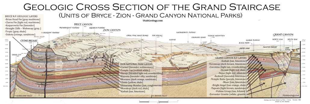
The Navajo Sandstone is a geologic formation in the Glen Canyon Group that is spread across the U.S. states of southern Nevada, northern Arizona, northwestColorado, and Utah; as part of the Colorado Plateau province of the United States.

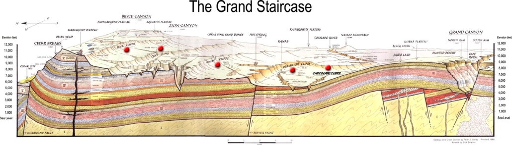
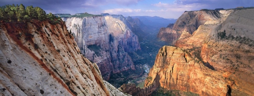
The Navajo Sandstone formation is particularly prominent in southern Utah, where it forms the main attractions of a number of national parks and monuments including Red Rock Canyon National Conservation Area,[3] Zion National Park, Capitol Reef National Park, Glen Canyon National Recreation Area, Grand Staircase-Escalante National Monument, and Canyonlands National Park.

Navajo Sandstone frequently overlies and interfingers with the Kayenta Formation of the Glen Canyon Group. Together, these formations can result in immense vertical cliffs of up to 2,200 feet (670 m). Atop the cliffs, Navajo Sandstone often appears as massive rounded domes and bluffs that are generally

Appearance and provenance

Navajo Sandstone frequently occurs as spectacular cliffs, cuestas, domes, and bluffs rising from the desert floor. It can be distinguished from adjacent Jurassic sandstones by its white to light pink color, meter-scale 
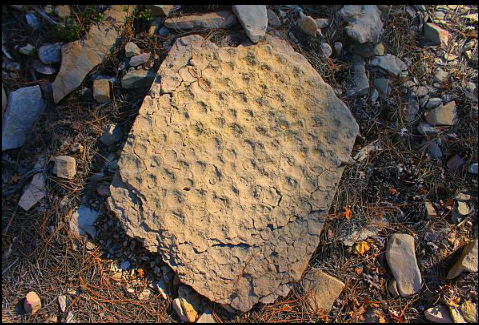
cross-bedding, and distinctive rounded weathering.

The wide range of colors exhibited by the Navajo Sandstone reflect a long history of alteration by groundwater and other subsurface fluids over the last 190 million years. The different colors, except for white, are caused by the presence of varying mixtures and amounts of hematite, goethite, andlimonite filling the pore space within the quartz sand comprising the Navajo Sandstone. The iron in these strata originally arrived via the erosion of iron-bearing silicate minerals.

Initially, this iron accumulated as iron-oxide coatings, which formed slowly after the sand had been deposited. Later, after having been deeply buried, reducing fluids composed of water and hydrocarbons flowed through the thick red sand which once comprised the Navajo Sandstone. The dissolution of the iron coatings by the reducing fluids bleached large volumes of the Navajo Sandstone a brilliant white. Reducing fluids transported the iron in solution until they mixed with oxidizing groundwater. Where the oxidizing and reducing fluids mixed, the iron precipitated within the Navajo Sandstone.

Depending on local variations within the permeability, porosity, fracturing, and other inherent rock properties of the sandstone, varying mixtures of hematite, goethite, and limonite precipitated within spaces between quartz grains. Variations in the type and proportions of precipitated iron oxides resulted in the different black, brown, crimson, vermillion, orange, salmon, peach, pink, gold, and yellow colors of the Navajo Sandstone.

The precipitation of iron oxides also formed laminea, corrugated layers, columns, and pipes of ironstone within the Navajo Sandstone. Being harder and more resistant to erosion than the surrounding sandstone, the ironstone weathered out as ledges, walls, fins, “flags”, towers, and other minor features, which stick out and above the local landscape in unusual shapes.


SOUTHWEST UTAH

Because of its thickness, massiveness, color, and its decorative carving, the Navajo sandstone is the most conspicuous and best known unit in the Mesozoic sequence in the plateau country. It has been described in many scientific and popular publications and pictured in pamphlets and on postcards issued by tourist bureaus and transportation companies. In Utah it surrounds the Henry Mountains, forms the famous White Cliffs and the walls of Glen Canyon. Complete sections are exposed in Paria Canyon, Kanab Canyon, Parunuweap Canyon, Zion Canyon, and LaVerkin Canyon, and in scores of other deep, narrow gorges that carry water from the Kaiparowits, the Paunsaugunt, and the Markagunt Plateaus. Generally throughout its expanse, the Navajo sandstone lies nearly flat and its sharply truncated edges are unscalable walls of commanding height. In eastern Southwest Utah part of the Navajo retains its normal attitude and is expressed in the topography as vertical cliffs; other parts have been steeply upturned and stand as ridges. The towering escarpment that rims the Kolob Terrace at the heads of Spring and Kanarra Creeks and outlines the lava-capped Square Mountain has been developed by cutting into Navajo sandstone, here fully 1,500 feet thick. Northward across the canyons of Murie, Shurtz, Squaw, and Coal Creeks, where horizontality of bedding is replaced by progressively steep inclination, the edge of the sandstone stands on the skyline as a rugged ridge, here and there broken into pyramids and domes. The Red Wall, prominently in view from Cedar City, is. the base of the uptilted Navajo, from which much of the underlying Chinle formation has been stripped.

Observations at many localities show that in composition and texture the Navajo sandstone in eastern Southwest Utah differs little from that exposed elsewhere. Its salient physical features were long ago outlined by Dutton in his pioneer study on the geology of Markagunt Plateau (1).

“The lithological characters of the Jurassic white sandstone render it a very conspicuous formation. Through a thickness of more than a thousand feet, sometimes of nearly two thousand feet, it is one solid stratum, without a single heterogeneous layer or shaly parting. A few horizontal cracks are seen here and there, but inspection shows that they are merely the seams where two systems of cross-bedding are cemented together. In general, it is one indivisible stratum. This massive character has had its effect upon the cliff-forms that have been sculptured out of it. These forms are bold headlands and gigantic domes, usually without any minor details, but simple in the extreme, and majestic by reason of their simplicity. . . . But of all the features of this rock the most striking is the cross-bedding. It is hard to find a single rock-face which is not lined off with rich tracery produced by the action of weathering upon the cross-lamination. The massive cliff fronts are etched from summit to base with a filagree as intricate and delicate as frost-work.”

Supplementing the original description by Dutton, lithic and strati-graphic observations recorded by later students reveal that the dominant cross bedding varies in style from place to place and is locally absent and that the sandstone includes thin, lenticular beds of dolomitic limestone, and in places argillaceous shale and calcareous conglomerate. Detailed examination shows that the Navajo sandstone in Southwest Utah is essentially an aggregate of clear quartz grains of which about 75 percent measure 0.08 to 0.75 millimeters in diameter ; that most of the grains are imperfectly rounded, though many are spherical and some plainly etched; and that, in addition to the dominant quartz, the rock contains fragmentary feldspar, mica, magnetite, more rarely zircon and tourmaline. The cement of the Navajo sandstone consists of loosely compacted lime or dolomite, and iron. The amount and chemical state of the iron oxides are indicated by the color tones: yellow, buff, tan, red, In a few places where leaching has removed the iron, the rock is white, but such great thicknesses of white rock as give character to the White Cliffs in Kanab and Johnson valleys and the Great White Throne in Zion Canyon are absent.

The Navajo sandstone is profusely jointed. Sets of roughly parallel joints with various trends and inclinations cut the sandstones into huge slabs. The major vertical joints are several hundred feet apart and are traceable for as much as a mile. But in places planes of fracture are so closely packed as to form “shatter belts.” On flat surfaces the rock joints, open or filled with calcite or iron, appear as surface markings and here and there provide runways for rills. On canyon walls they outline blocks, sheets, and slivers of rock preparatory to their removal by frost and combined with the bedding planes-horizontal, oblique, and curved-determine the shape of talus blocks. The uniformity of grain, the cross bedding, the weak cement, and the joints facilitate the production of the large and small scale erosion features, many times described as characteristic of the flat surfaces, the cliffs, buttresses, and canyon walls developed in the Navajo sandstone.

In Dutton’s (2) opinion, the sands that compose the Navajo were deposited in the sea: “The Jurassic sandstone appears to have been a littoral or offshore formation thrown down along the coast of the Mesozoic mainland, which occupied the region now forming the Great Basin . . . its red color becomes more common as we recede from the old shore line towards the east.” In common with his co-workers of the Wheeler and Powell survey, Dutton treated the Navajo sandstone as basal Jurassic, though recognizing the possibility that it may be “a mere upward continuation of the Vermilion Cliff series” (Chinle formation: Upper Triassic). More recent studies of sedimentation in the plateau country have compiled evidence that the Navajo is a terrestrial deposit, much of it eolian,20 and that its age is probably Middle Jurrassic.

In tracing the Navajo sandstone northwestward from its type locality in the Navajo Reservation, Arizona, it was noted that the part characterized by curved and angular crossbedding, laminae, and lack of division planes decreases in thickness. Particularly in areas where the Kayenta formation and the Wingate sandstone are lacking and the Navajo rests directly on the Chinle the usual single massive stratum is replaced by a massive stratum and below it a sequence of somewhat regular beds. In Southwest Utah fully half, in places nearly all, the Navajo is displayed as thick and thin layers composed chiefly of wedge-shaped groups of oblique crossbeds. These observations suggest that eastern Southwest Utah lies near the edge of an ancient interior basin where sediments deposited by streams were but slightly rearranged by wind.

SOUTHEAST UTAH

In the San Juan country the Navajo sandstone is exposed in the east and west flanks of the broad Monument up warp. The sandstone forms the crest and eastern slope of the “Comb”, the prominent ridge that crosses the San Juan and extends northward between Comb Wash and Butler Wash as a steeply dipping monocline, and continues to crop out along the east base of Elk Ridge and across the Causeway into the Indian Creek country.” The walls and mosques and alcoves that make the “wonderland” of the Allen Canyon country are chiefly exposures of Navajo sandstone.

In the remote Red Rock Plateau the Navajo is magnificently developed. The plateau is essentially one great sheet of sandstone, cut into huge segments by the San Juan, Castle, Moki, Red, and Colorado Canyons. On this plateau the Navajo shows its characteristic features of erosion. Along canyons and at their boxlike heads it forms vertical or even undercut walls-sheer cliffs 400 to 600 feet high that can be ascended only at fracture zones or on sand dunes that extend from the bottom to the rim. A traverse of miles of canyon floor may reveal no place where the walls can be climbed. Though the Navajo stands first among cliff makers in the plateau province, it does not form platforms or mesa tops. Unlike the Dakota(?) of Sage Plain and the Shinarump of Elk Ridge, which form extensive nearly horizontal plateaus, the Navajo shows very uneven surfaces. Its composition, texture, and structure combine to produce smooth or ribbed mounds on which stream ways are poorly defined. Between the San Juan River and upper Castle Wash and at the junction of the San Juan and the Colorado the surface of Red Rock Plateau is a maze of domes and saucer like depressions. The intricate network of narrow, deep canyons that carry the run-off from bare slopes seems to be arranged with little regard to surface topography.

The published descriptions of the Navajo sandstone in the Navajo country and in the Kaiparowits region apply equally well to the San Juan country and need only be ‘generalized here. In fact, the composition, structure, texture, and style of bedding of the Navajo are remarkably alike throughout the Colorado Plateaus: the differences relate chiefly to thickness, color, and degree of massiveness. Essentially the Navajo is a single massive bed of fine-grain ‘ marvelously cross-bedded sandstone composed of crystal-clear grains of quartz cemented by lime and iron. Cross-bedding is a scrollwork of curves and parallel lines etched on the surface and strengthened here and there by projecting seams of quartz and rows of cylindrical iron concretions. The Navajo sandstone includes lenses of thin regular bedded sandstone and lenses of resistant limestone a few inches to 5 feet thick and a few hundred feet long. On the rim of Lake Canyon dense blue-gray dolomitic limestone near the top of the Navajo caps low mesas and provided building materials for the walls of prehistoric structures. Numerous vertical and oblique joints outline slabs on cliff faces and in conjunction with cross-bedding determine the position and shape of buttresses, recesses, and alcoves on canyon walls and the caves once occupied by Cliff Dwellers.

As most of the Navajo in the San Juan country has been long exposed to erosion, its original thickness has been reduced. At Comb Ridge and in the Allen Canyon country 300 to 600 feet remains. In the south wall of Wilson Mesa, where the Navajo is overlain by younger strata, a complete section measured 880 feet. At most places west of the Colorado River measured thicknesses exceed 1,000 feet; at Zion Canyon, nearly 2,500 feet.

NORTHERN ARIZONA

STRUCTURE, TEXTURE, AND COMPOSITION.

The Navajo sandstone is nearly everywhere cross-bedded on a scale which for extent and perfection of detail is difficult to exaggerate. Angular cross bedding was observed, but the prevailing type is tangential; curved laminae become tangent to adjoining surfaces. Starting as highly inclined arcs of small radii the cross-bedding laminae gradually decrease in curvature until they merge into contact with the underlying strata. In some places the arcs are tangent to horizontal surfaces or meet them at angles of 1� or 2′; elsewhere arcs of various radii are tangent to one another. (See Pl. XII, A.) Many groups of curved laminae are sharply truncated along horizontal or inclined surfaces. In places the curved laminae have uninterrupted sweeps of 200 to 300 feet; commonly their length is measured in tens of feet, and many cliff faces are decorated by close-set loops and arabesques comparable with the lathe work in steel engraving. In general the cross-bedding laminae are outlined by layers of weakly cemented quartz grains that determine planes of fracture, but in places major joints exert a stronger control and furnish erosion remnants decorated on all sides by intersecting curved lines.

To the tangential cross bedding are due the exceptional erosion features of the Navajo sandstone the innumerable pockets, recesses, and alcoves bounded by curved planes which characterize this formation. Overhanging cliffs are common, and the beautiful arc of the Rainbow Bridge is only an unusually perfect example of the control exerted by curved lamination.

The prevailing color of the rock is light red and is surprisingly constant over large areas. Among the Segi Mesas and on the Rainbow Plateau the red tint is so boldly applied that no other color appears in the view. In places, however, dark reds and maroons are seen, and not uncommonly orange and even tan colors add variety to the landscape, and patches of white are not unusual. In the Echo Cliffs the rich red tints of the Navajo sandstone fade into yellow gray and become nearly white in the vicinity of Bitter Springs but the Wingate and the Todilto retain their dominant tones. It is interesting to note that all parts of the La Plata in Colorado are described as white and that the White Cliff sandstone of east-central Utah has been correlated with the La Plata.

The Navajo sandstone is composed of translucent quartz grains, with small amounts of feldspar, rare fragments of zircon, magnetite, garnet, pyroxene (?), and tourmaline (?). In two thin sections examined the grains are imperfectly rounded but without sharp edges; a third specimen consists of almost perfect spheres. The grains are of two sizes; probably 90 per cent of the rock consists of grains ranging between 0.15 and 0.25 millimeter in diameter; the other grains, formed as an interrupted coat on cross-bedding laminae, average about 0.65 millimeter. Only at a few localities were much larger pebbles of quartz, of shale, and of sandstone noted. In general the cement is calcite, with large or small amounts of iron oxide, which is reflected in the varying color of the rock. Hand specimens from the Echo Cliffs and the Chinle Valley have siliceous cement. In places the cement is stained green by copper, and in the White Mesa copper district the original cement is partly replaced by malachite and chrysocolla. Much of the cement is weak and grains of calcite and of kaolin are disseminated; the rock is consequently friable, and even where continuously swept by the wind crumbles under foot. It was found possible to trail a man who had strayed from camp by the hobnail prints he made on a bare ledge. In many places the joints in the Navajo are lined with quartz, and their position is indicated by a tracery of thin white ridges intersecting at various angles. In Copper Canyon, on Shato and Kaibito plateau and to a less extent elsewhere, some joints are lined with chrysocolla and other copper minerals.

The limestone, which is an almost universal feature near the top of the Navajo sandstone, is in lenses. The thin outcrops rarely extend more than a few hundred feet, and most of them are measured in tens of feet. The lenses are usually less than 1 foot thick and break up into shaly beds including sandstone. They are exceedingly resistant, however, and form the caps of low mesas and buttes, irregularly distributed over the otherwise smooth surfaces of Navajo sandstone exposures. The two specimens submitted to analysis proved to be dolomite. Chert and chalcedony are commonly found with the limestone.

CONDITIONS OF DEPOSITION.

The significant features of the Navajo sandstone are uniformity of grain, cross-bedding, and red color. Specimens taken from ledges 200 miles apart are indistinguishable in the laboratory by texture or composition or color; tangential cross bedding is persistent. The structure and composition of the rock suggests aridity and the uninterrupted control of the winds, and the “live dunes” now being formed on the floor of Chinle Valley differ only in color from the “frozen dunes” displayed in the bordering rock walls. There is little doubt that desert conditions prevailed in this region during part of Jurassic time, but the boundaries of this ancient Sahara and its relations to highlands and oceans are unknown. The thin lenses of dolomitic limestone and limestone conglomerate in the upper part of the Navajo sandstone probably represent local bodies of water of ephemeral character. It should be borne in mind, however, that these calcareous beds are in the stratigraphic position of the marine limestone of Kanab, described by Gilbert.

AGE AND CORRELATION.

No fossils have been found in the Navajo sandstone, and its age, like that of other formations of the La Plata group, is determined by stratigraphic position and lithologic similarity. It is the equivalent of the upper La Plata sandstone 2 of the La Plata Mountains, from which it differs in no essential except color and thickness.

On Dutton’s geologic map and sections 3 the massive “white sandstone” (Jurassic) is extended to cover the western edge of Kaibito Plateau. He says: “The extension of the Jura south of the Colorado and its exposure in the line of Echo Cliffs has been traced for nearly 60 miles.” In my view the sandstones forming the crest and escarpment of Echo Cliffs and the walls of Glen Canyon, mapped by Dutton as Triassic, belong in the La Plata group and Dutton’s descriptions and illustrations of the “Jurassic white sandstone” suggest lithologic equivalence with the Navajo and also with the massive phase of the McElmo. The upper limit of the La Plata along the southern base of Kaiparowitz Plateau has not been established. Sections on Warm Creek and Sentinel Creek include more than 100 feet of calcareous and gypsiferous shales and thin sandstones between typical Navajo sandstone and massive strata assigned to the McElmo.

I have been unable to recognize with assurance the Navajo sandstone in the Lower Cretaceous and Jura-Triassic strata along the San Juan described by Newberry, or in the Lower Dakota, Upper Dakota, and Triassic mapped by Holmes in the Carrizo Mountain area.

Grand Canyon

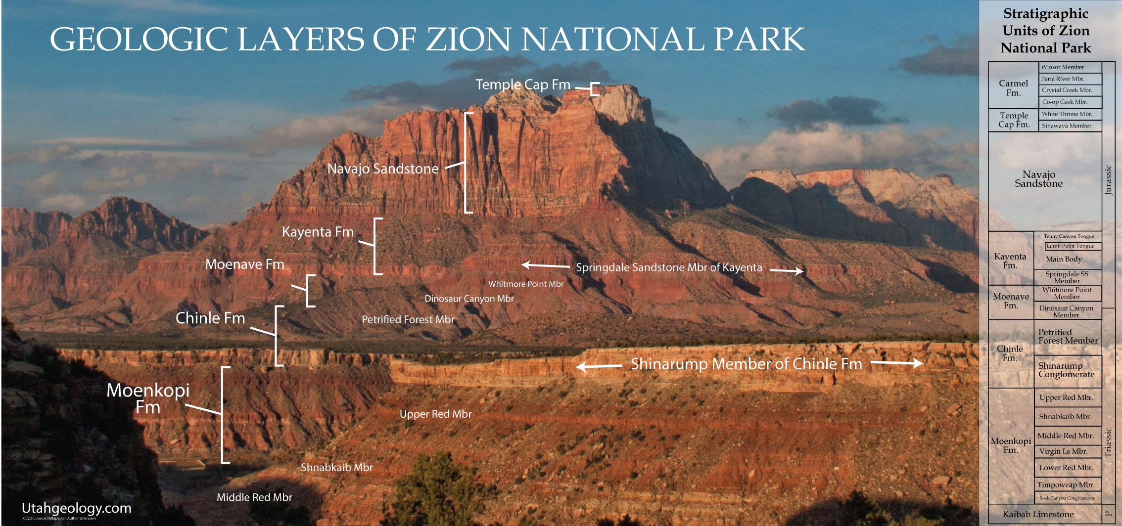
One of the most prominent and distinctive formations in the Colorado Plateau is the massive Navajo Sandstone. It weathers into nearly vertical cliffs and dominates the landscape wherever it is exposed. In the vicinity of Lee’s Ferry the Navajo Sandstone is approximately 1,400 feet thick and caps the high Vermillion and Echo cliffs behind the boat landing (Text-fig. 3). Exposures of the formation are abundant throughout much of the Navajo country to the northeast. In Utah the Navajo Sandstone forms the prominent White Cliffs north of Kanab and the walls of Zion Canyon. Precipitous canyons controlled by joints (fractures) (Text-fig. 3) are cut into most exposures of the formation and produce some of the most rugged and spectacular scenery of the West.

Large scale cross-bedding characterizes the Navajo Sandstone wherever it is exposed. Many outcrops contain some of the most spectacular development of this structure to be found anywhere in the world.

Navajo Sandstone consists of well-sorted, rounded grains of translucent quartz, many of which are etched and frosted. This, together with the large-scale cross-bedding, indicates that the Navajo sediments accumulated in a vast desert which covered much of Utah, Arizona, and New Mexico during early Jurassic time.