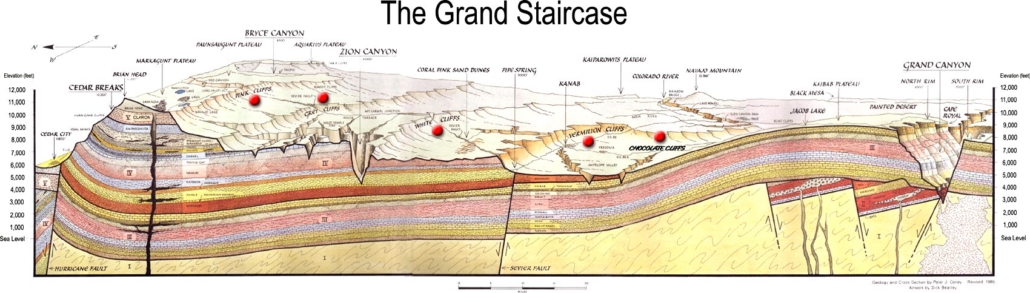
Morrison Formation (Geology of Utah’s Grand Staircase)
Explore unit thickness in All-in-One App

Exposure:
Within the Grand Staircase, the Morrison Formation is best exposed in Capital Reef National Park.
Age: Late Jurassic (Kimmeridgian) 155-148 Ma
Depositional Environment: Alluvial plain, fluvial channels and floodplains with paleosols
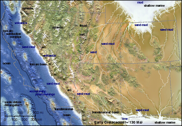
Tectonics:
Subduction to the west created a back arc rift basin (between Morrison basin and paleo Pacific Ocean).
Mountain ranges (rift shoulder) to the west were source for clastic sediment
Calderas in rift basin provided abundant ash fall during Brushy Basin deposition
Climate:
Located ~32° N (modern southern AZ)
Prevailing easterly winds (present day NE due to rotation of plate)
Warm, dry climate with high evaporation
Features:
Morrison Formation – 180-200 m thick
Tidwell Member (oldest)
- Alluvial plain – streams, overbank deposits, paleosols; locally (in Capitol Reef area)
- gypsiferous, hyper-saline lagoons
- Varicolored mudstone with interbedded sandstone, limestone, gypsum
Salt Wash Member (middle)
- Fluvial channel deposits, floodplain deposits, crevasse splays
- Predominately fine/medium sand – coarse sand/ pebble conglomerates; trough stratification,
- fining upward
Brushy Basin Member (youngest)
- Lacustrine/ wetlands; local fluvial channels
- Varicolored mudstone
- Mostly ground and surface water flowing to the east (present day NE)
- Losing streams with associated riparian environments prograding to the east
Floodplains with paleosols; grassy savannahs
Description:
The Morrison Formation is a distinctive sequence of Upper Jurassic sedimentary rock found in the western United States which has been the most fertile source of dinosaur fossils in North America. It is composed of mudstone, sandstone, siltstone, and limestone and is light gray, greenish gray, or red. Most of the fossils occur in the green siltstone beds and lower sandstones, relics of the rivers and floodplains of the Jurassic period.
It is centered in Wyoming and Colorado, with outcrops in Montana, North Dakota, South Dakota, Nebraska, Kansas, the panhandles of Oklahoma and Texas, New Mexico, Arizona, Utah, and Idaho. Equivalent rocks under different names are found in Canada.[2] It covers an area of 1.5 million square kilometers (600,000 square miles), although only a tiny fraction is exposed and accessible to geologists and paleontologists. Over 75% is still buried under the prairie to the east, and much of its western paleogeographic extent was eroded during exhumation of the Rocky Mountains.
It was named after Morrison, Colorado, where some of the first fossils in the formation were discovered by Arthur Lakes in 1877. That same year, it became the center of the Bone Wars, a fossil-collecting rivalry between early paleontologists Othniel Charles Marsh and Edward Drinker Cope. In Colorado, New Mexico, and Utah, the Morrison Formation was a major source of uranium ore.
https://web.archive.org/web/20171216143550/http://sed.utah.edu/Morrison.htm