Geology of Kolob Creek in Zion National Park
To the casual observer, the hydrology of the Colorado Plateau appears straightforward: water flows down-gradient, carving the spectacular “Slot Canyons” f..
To the casual observer, the hydrology of the Colorado Plateau appears straightforward: water flows down-gradient, carving the spectacular “Slot Canyons” f..
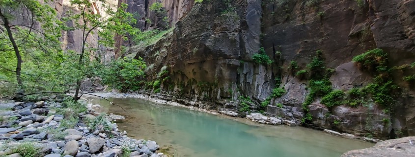
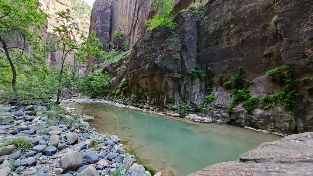
The Narrows is the narrowest section of Zion Canyon. It is an 18 mile gorge or canyon filled by the Virgin River just upstream from the part of Zion where the roads and trails end. This gorge, with walls a thousand feet tall and the river sometimes just twenty to thirty feet wide, is one of the most popular areas in Zion National Park. You can see the bottom section of the Narrows by hiking along the paved, wheelchair accessible Riverside Walk for one mile from the Temple of Sinawava. If you wish to see more, you will be walking in the Virgin River. Travel upstream in the Virgin River Narrows is allowed for the first 5 miles (until Big Spring) at which point travel is restricted to down canyon, permitted travelers only.
Wall-Street section of the Virgin River Narrows.
Most resources out there (including the Park Service brochure) like to say the Virgin River Narrows is a 16 mile hike from top to bottom. It is not! This number is based on old information, back when hikers used to be able to start at the end of the dirt road at Chamberlain Ranch. This is now against the rules, and hikers must start two miles sooner at the toilet facilities and parking lot above Chamberlain Ranch. A sign is posted saying “authorized vehicles only”, which forces hikers to hike the two mile dirt road making the entire hike from parking lot to parking lot 18 miles.
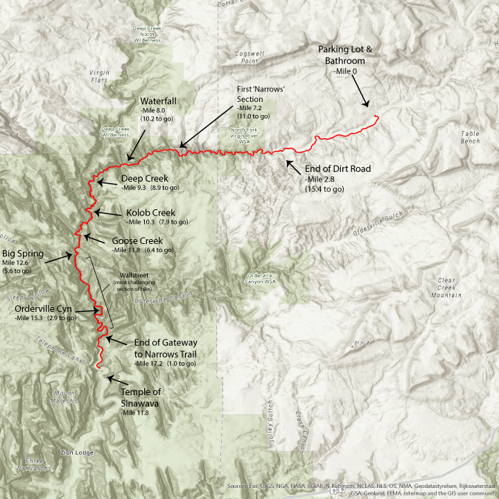
download a pdf printable version of the map here.
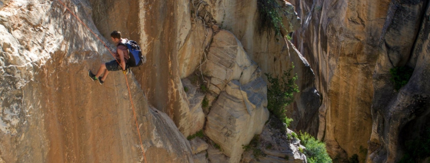
coming soon. Why Big Springs exists. What makes all the springs in the wallstreet section. Kolob Creek. Joint Systems.
Bottom Up Hike From the Temple of Sinawava (no permit required)
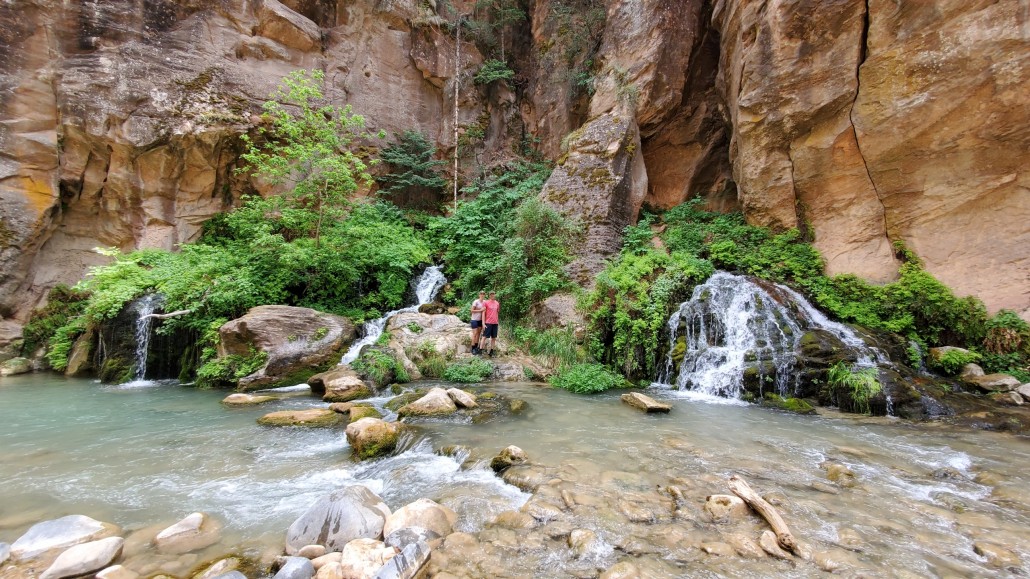
Hiking in The Narrows upstream as far as Big Spring does not require a permit. Doing the hike this way allows you to see some of the most spectacular and narrowest parts of the canyon. You can hike in the river for an hour and have a great experience, or you can hike as far as Big Spring, a strenuous, ten-mile round trip, all-day adventure.
Top Down Hike from Chamberlain’s Ranch (permit required)
You can also hike sixteen miles downstream over one or two days, entering the park soon after starting the hike and then exiting at the Temple of Sinawava. Those who choose this option must get a permit and arrange transportation for the one and a half hour ride to start the hike outside the park at Chamberlain’s Ranch.
What about flash floods?
The Narrows are susceptible to flash flooding because much of the surrounding area is bare rock that does not absorb water. During storms, runoff is funneled rapidly into the Narrows. During a flash flood the water level rises almost instantly–within seconds or minutes. Flash floods are common in Zion and hikers have been stranded, injured, and even killed by venturing into narrow, flood prone canyons.
Perhaps because it is covered in detail in Grade School and Middle School curriculum, one of the most asked geologic questions I hear from youth has to do with differentiating between the three types of volcanoes.
| Three Main Types of Volcanoes* | |||||
|---|---|---|---|---|---|
The three main types of volcanoes differ in shape, size, and make-up; the differences partly result from the different types of eruptions. | |||||
| Volcano Type | Volcano Shape | Volcano Size | Volcano Materials | Eruption Type | Utah Example |
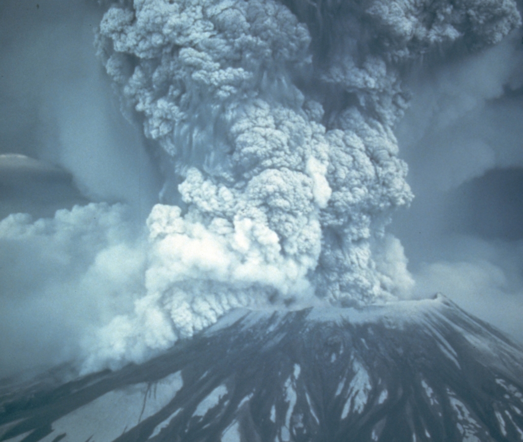
Cinder Cone | Steep conical hill with straight sides | Small less than 300m high | cinders | Explosive | Diamond Cinder Cone, Washington County |
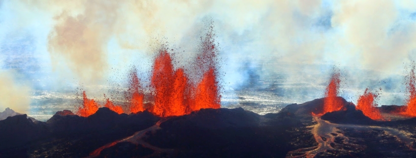
Shield Volcano | Very gentle slopes; convex upward (shaped like a warrior’s shield) | Large over 10s of kms across | fluid lava flows (basalt) | Quiet | Cedar Hill, Box Elder County |
Stratovolcano | Gentle lower slopes, but steep upper slopes; concave upward | Large 1-10 km in diameter | numerous layers of lava and pyroclastics | Explosive | Mount Belknap, Tushar Mountains, Paiute County |
In the State of Utah there are many examples of the three main types of volcanoes. The following is a brief introduction to Utah’s volcanoes; only several of numerous volcanoes are mentioned.
Stratovolcanoes erupted in western Utah between about 40 to 25 million years ago. At this time, Utah was closer to a continental-oceanic plate boundary where an oceanic plate (Farallon) was subducting underneath the North American continental plate. Stratovolcanoes are found at these types of plate boundaries.
Today’s active stratovolcanoes include those in the Cascade Range in Washington, Oregon, and California where an oceanic plate (Juan de Fuca) is subducting underneath the North American continental plate.
Two examples of Utah’s most recent stratovolcanoes are Mount Belknap in the Tushar Mountains and Monroe Peak on the Sevier Plateau. These stratovolcanoes exists on the tail end of a line of explosive volcanism that extended from near Richfield, southwestward to the Nevada border. Like ancient Yellowstone National Park, many of these volcanoes were among the largest volcanoes to ever erupt in North America.
Because these volcanoes are old and have been extensively eroded, it is difficult to distinguish the original volcano shapes.
Shield volcanoes and cinder cones started to erupt about 12 million years ago after plate motions and resulting crustal forces changed.
Compressional forces had eased, and the crust started to stretch between the Wasatch Range in Utah and the Sierra Nevada Range in California. This extension created splintered zones in the Earth’s crust where magma rose to the surface creating shield volcanoes and cinder cones. These types of volcanoes are far less explosive than stratovolcanoes and tend to create smaller deposits. Because the lava from shield volcanoes comes from a deeper source and contains more iron and less silica than stratovolcanoes, they tend to leave darker and thinner magma deposits.
The most recent volcanic activity in Utah occurred about 600 years ago in the Black Rock Desert (Millard County). The only place in the United States were these types of volcanoes are currently active is Hawaii.

Iceland and Hawaii are great modern examples of the shield volcanoes which have periodically erupted in Utah over the last 15 million years.
Science LanguageVolcano – a vent (opening) at the Earth’s crust through which magma (molten rock) and associated gases erupt. |
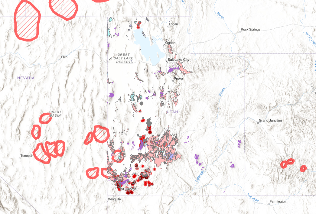
Map of Utah Volcanics. Hatched circles are ancient calderas. Pink shaded areas are exposed Rhyolite ash-fall and ash-flow tuffs (mostly Eocene/Oligocene). Purple are basalt deposits from Hawaii style lavas (mostly from the last 3 million years). Red starbursts are cinder cone volcanic vent/scoria cones which erupted the basaltic lava flows. Purple splotches on peaks of the Colorado Plateau/Colorado river area are oligocene/miocene laccolithic intrusions.
.
Use this map to zoom in and explore Utah’s various volcanic deposits. Each element can be clicked for more details. The top arrow opens a Legend which explains the meaning of the maps various features.Utah Volcano Map
.
Age of Major Volcanoes in Utah and the Intermountain West.
–Valles Caldera/Jemez Volcanic Field: 1.2-1.3 mya / 14 mya
–Yellowstone Caldera: 2.1, 1.3 & .631 mya eruptions
–Long Valley Caldera (Bishop Tuff): .761 mya eruption
–San Francisco Peaks Volcano (Arizona): 2.8 -.4 mya eruptions
–Mount Rainer Volcano: 2 – .5mya (Most Cascade stratovolcanoes = 2mya-0.1mya)
–Mount Shasta Volcano: .590k (last eruption 10k yrs ago)
(Bill Williams Peak 2.8mya, Kendrick Peak 1.4mya, Sitgreaves Mountain 1.9mya, Humphries Peak ?)
-White Mountain Tuff/Rhyolite: .400 mya
–Mineral Mountains Beaver County: 18mya. (but starting in Oligocene)
–Silverton Caldera/San Juan Caldera: 27.6/28.4mya
-Boulder Mountain Tuff/Antimony Tuff: 25.13 to 26 Ma. (Cant be equal to Bishop Cong!)
-Utah Laccoliths: 31-20mya. Henrys/Abajo/La Sal (excess argon)
–Marysville Volcanics: 40-25mya (32-22mya)
–Absaroka Volcanics/Sunlight Peak: 53-43mya
–Bishop Conglomerate Ash Beds: 36-27mya (Oligocene=33.9-23 ma)
–Wah Wah Springs Caldera: 30.06mya
–Desert Mountain Volcanics: 40-30mya
-La Plata Intrusion: 75-60mya
–Carrizo Mountains Intrusion/Pastora Peak: 73.8-70.6mya (excess argon too? – both use same modern hornblende argon dating)
-Sierra Nevada Batholith: mostly 105-85mya (Cretaceous)
-Notch Peak Granite Intrusion: 170 mya (Jurassic).
–Twentynine Palms Monzonite, Earliest of Joshua Tree NP intrusions: 170mya (Jurassic). Most others are K.
-Snake River Calderas= McDermitt 16-15.1mya, Owyhee 13.8-12mya, Bruneau 12.5-11.3mya, Twin Falls 10-8.6mya, Picabo 10.2mya, Heise 6.6-4.4mya, Huckleberry/IslandPark/Yellowstone 2-.6mya
–Columbia River Basalts: 17-14mya
Utah’s sandstone units tend to be exposed on the flanks of large gentle uplifts …
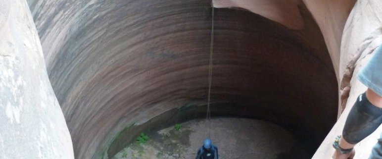
Keeper potholes are found in slot canyons. In the recent decades “slot” canyoneering has become a major sport, and very few areas of the world have nearly the number or diversity of slot canyons as southern Utah. People come from all over the world to descend slot canyons of varying difficulty in places such as Zion National Park, Grand Staircase–Escalante National Monument, Capitol Reef National Park, the San Rafael Swell, and Glen Canyon National Recreation Area.
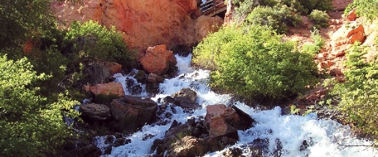
Nestled in the northwestern corner of Kane County is a geologically unique feature that receives relatively few visitors. Although most people in Utah have seen caves and waterfalls, it is peculiar for a waterfall to emerge from a cave system. Cascade Falls does just that, as an underground river emerges from a deep cave system and cascades down a steep cliff face.
![]()