
Grand Canyon’s Bright Angel Shale (Geology of The Grand Staircase)
Explore unit thickness in All-in-One App

Exposure: The unit is most famous for forming the wide, greenish “Tonto Platform” in the Grand Canyon, Arizona. It is best viewed along the Bright Angel Trail or the North Kaibab Trail, where it creates a distinct recessive slope between the cliff-forming Tapeats Sandstone below and the Muav Limestone above.
Age: Middle Cambrian (approx. 505–515 Ma)
Lateral Equivalents: Pioche Shale (UT/NV), Langston Fm (Northern UT/ID), Wolsey Shale (WY/MT), Peerless Fm (CO), Carrara Fm (NV)
Depositional Environment: The environment was a distal, shallow marine shelf to subtidal mudflat. It sat below the constant agitation of the surf zone but was shallow enough to be affected by storm waves. The presence of glauconite suggests slow sedimentation rates in a relatively quiet, normal-salinity marine setting.
Paleogeography: The region was located on the western “trailing” passive margin of Laurentia. During the Middle Cambrian, the Southwest was positioned at equatorial latitudes, specifically within the tropical belt. The area consisted of a vast, flooded continental shelf with no significant terrestrial vegetation to hold back sediment.
Tectonics: Tectonically, this was a period of extreme stability following the Neoproterozoic rifting of Rodinia. The lack of mountain building (orogeny) allowed for a remarkably flat landscape, enabling the “Great Unconformity” to be draped by thousands of square miles of flat-lying, minimally deformed marine sediments as sea levels rose.
Climate: The climate was predominantly tropical to subtropical. With no land plants to regulate carbon dioxide or albedo, the Earth was in a “greenhouse” state. Warm, shallow seas covered much of the continent, promoting high calcium carbonate saturation and vibrant, though primitive, biological productivity in the water column.
Features: The unit is notable for its distinct slope-forming weathering pattern and “candy-striped” appearance caused by alternating layers of siltstone and shale. It frequently contains abundant mud-cracks, ripple marks, and green glauconite pellets, which give the shale its characteristic olive-drab to forest-green hue in many canyon exposures.
Fossils: The Bright Angel is a world-class source for Middle Cambrian trilobites, including Alokistocare and Glossopleura. It is also famous for its diverse trace fossils (ichnofossils), brachiopods, and primitive sponges, capturing the rapid diversification of body plans during the Cambrian Explosion within the muddy seafloor sediments.


Description:
The Bright Angel Shale represents a pivotal chapter in the Paleozoic history of the American Southwest, serving as the middle member of the Tonto Group—a classic “transgressive sequence” that records the steady encroachment of the sea onto the North American craton. Formed approximately 505 to 515 million years ago during the Middle Cambrian, the unit consists primarily of fissile, greenish-gray micaceous shales, siltstones, and thin-bedded fine-grained sandstones. As the Sauk megasequence progressed, the high-energy beach environments of the underlying Tapeats Sandstone migrated eastward, giving way to the deeper, quieter waters of the Bright Angel. This depositional shift reflects a deepening marine shelf where fine-grained clastics could settle below the fair-weather wave base. In the modern world, geologists often look to the broad, shallow shelf of the Yellow Sea or parts of the northern Australian shelf as analogs, where sediment-starved epicontinental seas allow for the accumulation of extensive mudflats and subtidal silts.
Deposited along the passive margin of western Laurentia (the ancient core of North America), the Bright Angel Shale is a testament to the larger Cordilleran tectonic context. During this time, the supercontinent Rodinia had finished rifting apart, leaving behind a broad, flat coastal plain. The unit’s distinct “slope-forming” profile in the Grand Canyon is punctuated by intensive bioturbation, specifically the ichnofossil Skolithos and Cruziana—traces of ancient organisms churning through the mud. The geochemical environment was likely dysoxic to oxic, supporting a burgeoning community of marine life that benefited from the nutrient-rich runoff of the barren terrestrial landscape. Because the Cambrian sea transgressed from the west to the east over millions of years, the Bright Angel exhibits significant diachroneity; it is older in the western Grand Canyon and younger as it moves toward the cratonic interior, demonstrating how geologic units “climb” through time during a marine transgression.
On a regional scale, the Bright Angel Shale does not exist in isolation but is part of a massive, interconnected system of Cambrian marine deposits across the Rocky Mountain corridor. In northern Utah and southeastern Idaho, the unit is time-equivalent to the Pioche Shale and parts of the Langston Formation, which similarly record the transition from basal quartzites to trilobite-bearing mudstones. Further north and east into Wyoming and Montana, the Gros Ventre Formation and the Wolsey Shale represent the same sea-level rise, albeit with slight variations in sediment source and mineralogy. In Colorado, the Peerless Formation (often found above the Sawatch Quartzite) serves as the distal, younger equivalent. These units collectively define the “Cambrian Explosion” of life in the West, providing the primary substrate for some of the planet’s first complex reef-building organisms and diverse trilobite assemblages that flourished in the tropical, sun-drenched waters of the Cambrian shelf.
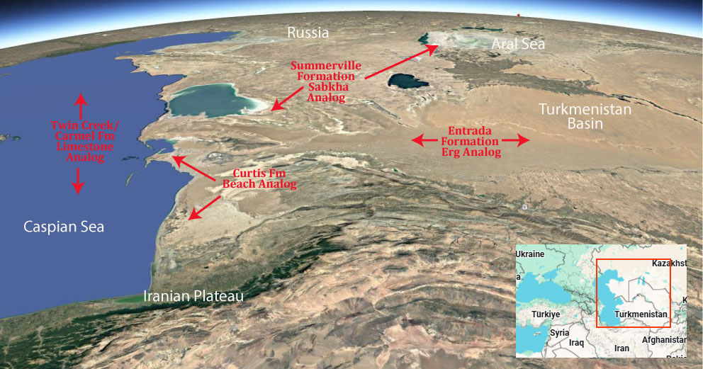
Modern Analog to Utah’s Middle Jurassic
.
Paleogeography or Depiction of Utah during Middle Jurassic

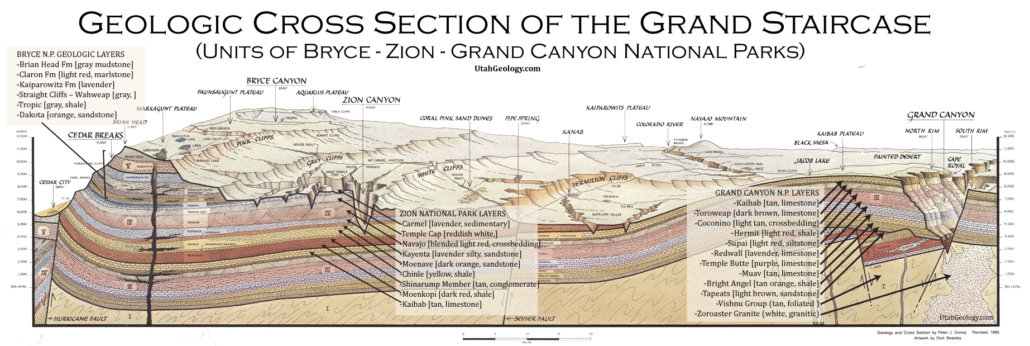
What is the Grand Staircase?
The Grand Staircase is a unique and extensive exposure of Earth’s history, showcasing over 200 million years of sedimentary rock layers. Geologists often liken these layers to a “book,” allowing for a detailed study of the Earth’s past, including changes in climate and environment.
The major sedimentary rock units exposed in the Grand Canyon range in age from 200 million to 600 million years and were deposited in warm shallow seas and near-shore environments. The nearly 40 identified rock layers of Grand Canyon form one of the most studied geologic columns in the world.

[flickr_tags user_id=”95435349@N04″ randomize=”true” margins=”4″ pagination=”numbers” tags=”navajo” max_num_photos=”9″]
[flickr_tags user_id=”95435349@N04″ tags=”chinle, navajo”]