
• Link to Facebook
  • Link to Instagram
  • Link to Youtube
  • Home
  • Tours
  • About
  • Contact
UtahGeology
  • Guided Tours
  • Hiking Guides
    • Geologic Hiking Guides
  • Geoarchaeology
    • Archaeology Explorer
    • Were the Ice Ages Caused by True Polar Wandering?
  • Geologic History
    • Utah Geologic History
    • Geologic History Overview
    • Geologic History of Utah & the Colorado Plateau
  • Road Guides
    • Utah Geologic Road Guides
    • Road Guides Overview
  • Geologic Formations
    • Geologic Formations
    • Geologic Formations Overview
  • Stratigraphic Columns
    • Utah Stratigraphic Columns
    • Stratigraphic Columns Overview
    • Layer Thickness Map
  • More
    • About
    • Contact
    • Geo Imagery
    • Earthquake Viewer
    • Interactive Map Gallery
    • Whats New?
    • Image & Copyright Policy
    • Web Links
  • Click to open the search input field Click to open the search input field Search
  • Menu Menu
You are here: Home1 / Geologic Formation Pages2 / Grand Canyon’s Muav Limestone (Geology of The Grand Staircase)

Grand Canyon’s Muav Limestone (Geology of The Grand Staircase)
March 7, 2026/in Geologic Formation Pages/by Lance Weaver
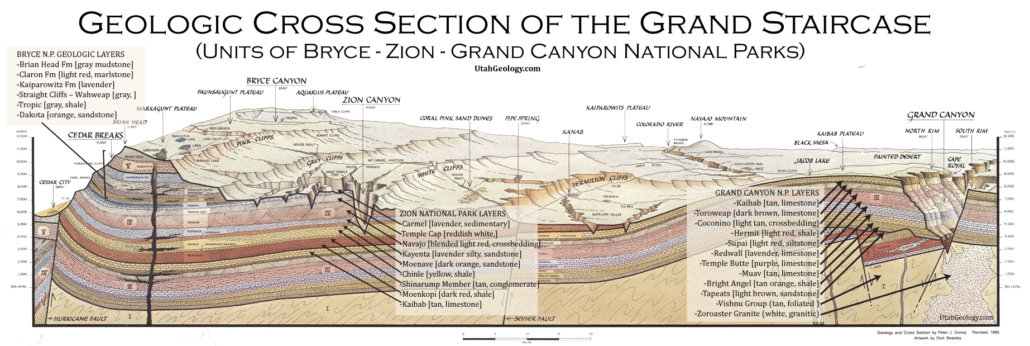
Geologic Cross section of the layers of The Grand Staircase from Bryce through Zion to the Grand Canyon National Parks. Note the Navajo forms the walls of Zion Canyon.

Explore unit thickness in All-in-One App

Grand Staircase Strat Column (Link).

Exposure: Best seen in the Grand Canyon as the top layer of the Tonto Platform (e.g., along the Bright Angel Trail). It also crops out in the Virgin River Gorge of Arizona/Utah and the Frenchman Mountain area near Las Vegas.

Age:  Middle Cambrian, 505-495 million years ago.

Depositional Environment: Primarily a shallow marine carbonate shelf. It transitioned between subtidal flats and deeper offshore “ramp” environments. The frequent silt partings suggest a fluctuating sea level where muddy terrestrial runoff occasionally mixed with the clear-water lime muds of the open shelf.

Paleogeography: Part of the western margin of Laurentia. The region was located near the equator, meaning the “Southwest” was actually a tropical, westward-facing coastline at the time. The vast, flat interior of the continent lay to the east, largely devoid of land plants.

Tectonics: Occurred during a passive margin phase. The crust was cooling and subsiding following the earlier breakup of the supercontinent Rodinia. There was very little tectonic deformation or volcanic activity, leading to the remarkably horizontal and consistent layering seen across the Colorado Plateau today.

Climate: Tropical to subtropical. Because Laurentia sat astride the equator, the waters were warm and conducive to carbonate chemistry. The lack of land vegetation meant that weathering on the continent was purely chemical and physical, leading to high mineral runoff into the warming Cambrian seas.

Features: Notable for its mottled, “edgewise” conglomerates and thin, silty interbeds. The limestone often weathers to a dull orange or buff color on the surface, but when freshly broken, it reveals a dark, fine-grained gray or green interior. It forms distinctive “stairstep” cliffs.

Fossils: Contains a variety of Middle Cambrian marine life, most notably trilobites (like Alokistocare), brachiopods, and hyoliths. However, the most pervasive “fossils” are ichnofossils—the preserved burrows and tracks of unknown worm-like creatures that created the formation’s signature mottled texture through bioturbation.

View looking north from Tuweap area near Toroweap Point.

Description:

The Muav Limestone represents the climactic, “deepest-water” chapter of the classic Tonto Group sequence, a geologic trilogy that records the Great Cambrian Transgression across the Southwest. While the underlying Tapeats Sandstone and Bright Angel Shale represent beach and muddy near-shore environments, the Muav signifies a time when the sea had moved far enough inland to allow for the deposition of carbonate muds. In the Grand Canyon and southern Utah, the Muav is a cliff-forming unit, though its ledges are often “stairstepped” or mottled compared to the sheer face of the much younger Redwall Limestone. It is primarily composed of calcareous (lime-rich) and dolomitic mudstones, characterized by a unique “mottled” appearance caused by ancient burrowing organisms that churned the seafloor before the sediment hardened—a process known as bioturbation.

Depositionally, the Muav formed on a vast, shallow marine shelf known as an epicontinental sea. During the Middle Cambrian (approx. 505 Ma), North America—then part of the paleocontinent Laurentia—was tilted and partially submerged. The Muav was deposited in the “middle shelf” zone, where the water was clear enough for carbonate precipitation but still close enough to the coast to receive occasional pulses of silt and clay. These pulses created the thin, micaceous partings that separate the thicker limestone beds. A modern analog for this environment would be the inner Sahul Shelf off the northern coast of Australia or parts of the Yucatán Platform, where broad, shallow carbonate ramps transition from muddy shorelines to clear-water limestone-producing factories.

In the broader Cordilleran context, the Muav Limestone is a testament to the “passive margin” phase of Western North America. During this period, there were no towering mountains to the west; instead, the continent thinned out into a wide, submerged plain. The Muav thickens significantly as you move westward toward the Cordilleran Miogeocline in Nevada, reflecting a seafloor that was gently sloping into deeper oceanic basins. This stable tectonic setting allowed for the accumulation of hundreds of feet of sediment without the interruption of volcanic activity or mountain building. However, the top of the Muav is marked by a dramatic unconformity; a massive gap in the geologic record exists between the Muav and the overlying Devonian rocks, where millions of years of history were eroded away before the next layer was laid down.

Modern Analog to Utah’s Middle Jurassic
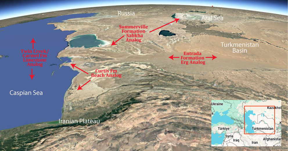
Trade this out with the Indus Delta!

.

Paleogeography or Depiction of Utah during Middle Jurassic

What is the Grand Staircase?

The Grand Staircase is a unique and extensive exposure of Earth’s history, showcasing over 200 million years of sedimentary rock layers. Geologists often liken these layers to a “book,” allowing for a detailed study of the Earth’s past, including changes in climate and environment.

The major sedimentary rock units exposed in the Grand Canyon range in age from 200 million to 600 million years and were deposited in warm shallow seas and near-shore environments. The nearly 40 identified rock layers of Grand Canyon form one of the most studied geologic columns in the world.

[flickr_tags user_id=”95435349@N04″ randomize=”true” margins=”4″ pagination=”numbers” tags=”navajo” max_num_photos=”9″]

[flickr_tags user_id=”95435349@N04″ tags=”chinle, navajo”]
Tags: formations, geology, muav limestone
Share this entry
  • Share on Facebook
  • Share on X
  • Share on WhatsApp
  • Share on Pinterest
  • Share on LinkedIn
  • Share on Tumblr
  • Share on Vk
  • Share on Reddit
  • Share by Mail
https://utahgeology.com/wp-content/uploads/2025/07/utah-geology-site-logo-420px-new.png 0 0 Lance Weaver https://utahgeology.com/wp-content/uploads/2025/07/utah-geology-site-logo-420px-new.png Lance Weaver2026-03-07 02:23:432026-03-10 23:39:36Grand Canyon’s Muav Limestone (Geology of The Grand Staircase)
You might also like
Grand Canyon’s Redwall Limestone (Geology of The Grand Staircase)
Entrada Formation (Geology of Utah’s Grand Staircase)
Summerville Formation (Geology of Utah’s Grand Staircase)
Toroweap/Coconino/White Rim Sandstone (Geology of The Grand Canyon)
Moenkopi Formation (Geology of Utah’s Grand Staircase)
Kaibab Limestone (Geology of The Grand Staircase)

Welcome

About me
Lance Weaver. about me.


Book a Tour

Popular
  • Tracks, Traces & Other Fossils of The Grand Canyon &...January 7, 2025 -
  • When Was The Colorado River Formed?February 21, 2025 -
  • Were the Ice Ages Caused by True Polar Wandering?September 21, 2020 -
  • Navajo SandstoneApril 16, 2015 -
  • The Vishnu SchistNovember 14, 2018 -
  • Take Away Lessons from my Experience with the Jerold Williams...August 10, 2015 -
  • The Geology of Zion National ParkNovember 14, 2018 -
  • Utah’s Three Types of VolcanoesMay 26, 2015 -
  • Grand Canyon’s Bright Angel Shale (Geology of The...March 10, 2026 -
Recent
  • When Was The Colorado River Formed?February 21, 2025 -
  • Tracks, Traces & Other Fossils of The Grand Canyon &...January 7, 2025 -
  • Grand Canyon’s Bright Angel Shale (Geology of The...March 10, 2026 -
  • Grand Canyon’s Tapeats Sandstone (Geology of The...March 10, 2026 -
  • Grand Canyon’s Muav Limestone (Geology of The Grand...March 7, 2026 -
  • Grand Canyon’s Redwall Limestone (Geology of The...March 7, 2026 -
  • The Cretaceous (Cretassic) Period: A Geologic Proposition...March 2, 2026 -
  • A Geologic Overview of Lake Powell, UtahFebruary 15, 2026 -
  • Pine Park and the Ancient Supervolcanoes of Southwestern...February 15, 2026 -
  • The Weaver Precessional Polar Oscillation Cycle & Core-Mantle...January 3, 2026 -
Comments
  • Lance WeaverIf you want to visit some of these formations check out...May 11, 2026 - by Lance Weaver
  • Mads Erik HusdalThe amount of work you have put in this is mind boggling!...February 23, 2026 - by Mads Erik Husdal
  • Gabor Szuecs dr.Because the pole was not where it is today. Around the year...February 8, 2026 - by Gabor Szuecs dr.
  • Alan FullerUpdate to previous post. After a more thorough read I have...December 30, 2025 - by Alan Fuller
  • Alan FullerFantastic piece of work I think you have basically described...December 26, 2025 - by Alan Fuller
  • Lance WeaverNo. Despite what some say, there are no specific 'angles'...November 21, 2025 - by Lance Weaver
  • Mark RademakerLance, i have read that the cross beds of Checkerboard Mesa...November 9, 2025 - by Mark Rademaker
  • Mark RademakerLance, have you dug into Dr. John Whitmore's material in...November 9, 2025 - by Mark Rademaker

Follow us on Facebook

UtahGeology
Logo image
Go to facebook page
Join the Facebook community!

Tag Cloud

Frontpage Article Geoarchaeology Geologic Formation Pages Geologic Hiking Guides Images News Uncategorized

Important Pages

Privacy Policy,    About utahgeology.com,    Contact Us,   
Image & Copyright Policy

Relevant Links

  • Utah Geological Survey
  • U.S. Geological Survey
  • Arizona Geology Blog
  • Durango Bill
  • Zion Experiences

Contact Me

Utahgeology is a 501c nonprofit. If you would like to contact me, drop me a line from the contact page. Or if you have questions about geology, call me during normal work hours at the Utah Geological Survey.
© Copyright - UtahGeology - Enfold Theme by Kriesi
  • Link to Facebook
  • Link to Instagram
  • Link to Youtube
Link to: Grand Canyon’s Redwall Limestone (Geology of The Grand Staircase) Link to: Grand Canyon’s Redwall Limestone (Geology of The Grand Staircase) Grand Canyon’s Redwall Limestone (Geology of The Grand Staircase)Link to: Grand Canyon’s Tapeats Sandstone (Geology of The Grand Staircase) Link to: Grand Canyon’s Tapeats Sandstone (Geology of The Grand Staircase) Grand Canyon’s Tapeats Sandstone (Geology of The Grand Staircase)
Scroll to top Scroll to top Scroll to top