• Link to Facebook
  • Link to Instagram
  • Link to Youtube
  • Home
  • Tours
  • About
  • Contact
UtahGeology
  • Guided Tours
  • Hiking Guides
    • Geologic Hiking Guides
  • Geoarchaeology
    • Archaeology Explorer
    • Were the Ice Ages Caused by True Polar Wandering?
  • Geologic History
    • Utah Geologic History
    • Geologic History Overview
    • Geologic History of Utah & the Colorado Plateau
  • Road Guides
    • Utah Geologic Road Guides
    • Road Guides Overview
  • Geologic Formations
    • Geologic Formations
    • Geologic Formations Overview
  • Stratigraphic Columns
    • Utah Stratigraphic Columns
    • Stratigraphic Columns Overview
    • Layer Thickness Map
  • More
    • About
    • Contact
    • Geo Imagery
    • Earthquake Viewer
    • Interactive Map Gallery
    • Whats New?
    • Image & Copyright Policy
    • Web Links
  • Click to open the search input field Click to open the search input field Search
  • Menu Menu
You are here: Home1 / Geologic Hiking Guides2 / The Virgin River Narrows (how far is it? geology of?)

The Virgin River Narrows (how far is it? geology of?)

August 10, 2018/0 Comments/in Geologic Hiking Guides/by Lance Weaver

What is the Zion Virgin River Narrows? (Zion National Park)

The Narrows is the narrowest section of Zion Canyon. It is an 18 mile gorge or canyon filled by the Virgin River just upstream from the part of Zion where the roads and trails end. This gorge, with walls a thousand feet tall and the river sometimes just twenty to thirty feet wide, is one of the most popular areas in Zion National Park. You can see the bottom section of the Narrows by hiking along the paved, wheelchair accessible Riverside Walk for one mile from the Temple of Sinawava. If you wish to see more, you will be walking in the Virgin River. Travel upstream in the Virgin River Narrows is allowed for the first 5 miles (until Big Spring) at which point travel is restricted to down canyon, permitted travelers only.

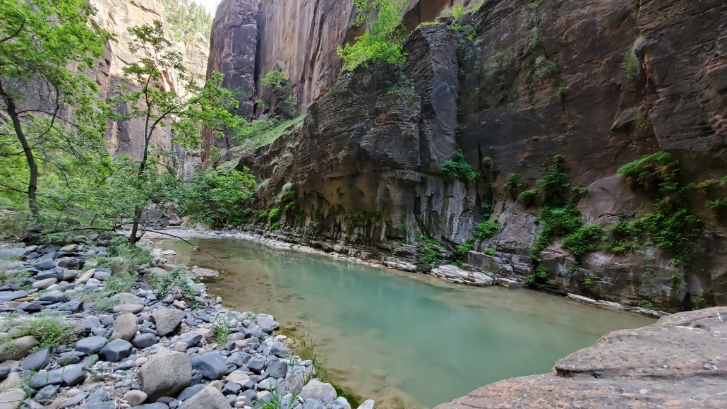
Wall-Street section of the Virgin River Narrows.


How far is the Virgin River Narrows Hike top to bottom?

Most resources out there (including the Park Service brochure) like to say the Virgin River Narrows is a 16 mile hike from top to bottom. It is not!  This number is based on old information, back when hikers used to be able to start at the end of the dirt road at Chamberlain Ranch.  This is now against the rules, and hikers must start two miles sooner at the toilet facilities and parking lot above Chamberlain Ranch. A sign is posted saying “authorized vehicles only”, which forces hikers to hike the two mile dirt road making the entire hike from parking lot to parking lot 18 miles.

Distances Map of the Virgin River Narrows

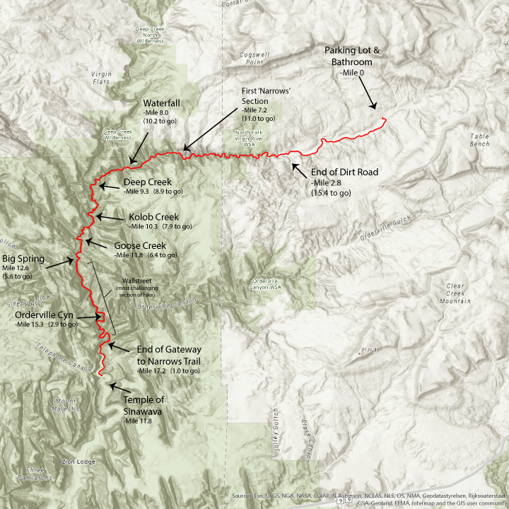
download a pdf printable version of the map here.

Interesting Geology Sites in the Virgin River Narrows

coming soon.   Why Big Springs exists.  What makes all the springs in the wallstreet section.  Kolob Creek.  Joint Systems.

How can I hike The Narrows?
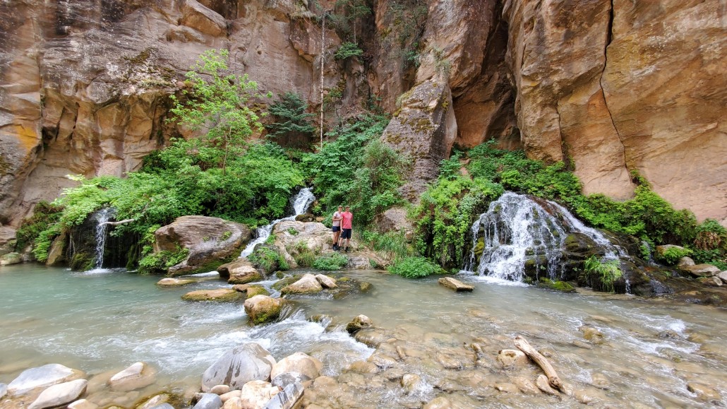
A hike through The Narrows requires hiking in the Virgin River. You must get your feet wet since there is no trail. Most people choose to start their hike from the Temple of Sinawava via the Riverside Walk and then walk upstream before turning around and hiking back down to the Temple of Sinawava.

Bottom Up Hike From the Temple of Sinawava (no permit required)
Hiking in The Narrows upstream as far as Big Spring does not require a permit. Doing the hike this way allows you to see some of the most spectacular and narrowest parts of the canyon. You can hike in the river for an hour and have a great experience, or you can hike as far as Big Spring, a strenuous, ten-mile round trip, all-day adventure.

Top Down Hike from Chamberlain’s Ranch (permit required)
You can also hike sixteen miles downstream over one or two days, entering the park soon after starting the hike and then exiting at the Temple of Sinawava. Those who choose this option must get a permit and arrange transportation for the one and a half hour ride to start the hike outside the park at Chamberlain’s Ranch.

What about flash floods?
The Narrows are susceptible to flash flooding because much of the surrounding area is bare rock that does not absorb water. During storms, runoff is funneled rapidly into the Narrows. During a flash flood the water level rises almost instantly–within seconds or minutes. Flash floods are common in Zion and hikers have been stranded, injured, and even killed by venturing into narrow, flood prone canyons.

Always check the weather forecast and the flash flood potential before you start your trip. Despite the forecast, flooding is possible at any time, and floods have occurred on days they were not expected. Your safety is your responsibility.
 
Hiking in the river is strenuous. The water is often murky and the bottom of the river is covered with rocks about the size of bowling balls. This makes proper footwear and bringing in trekking poles or a walking stick essential. The Narrows may be closed in the spring due to flooding while the snow melts off the upland areas to the north if the flow rate is higher than 120 cubic feet per second (3.4 m3/s). Thunderstorms can cause The Narrows to flash flood during the summer. Rain showers upriver can cause flash floods in the canyon without it raining over the canyon itself. Thus, hikers should exercise caution when hiking The Narrows during rainy periods as the winding canyon and sheer walls make approaching flash floods all the more sudden and difficult to evade.
 
Geology of the Narrows
The Virgin River narrows is a deep narrow canyon traversing one geologic unit, the Navajo Sandstone.  Much of the canyon fallows joint systems which the river has exploited and deepened.  For details on the geologic nature of the Navajo Sandstone, see my educational article on that unit here…

Share this entry
  • Share on Facebook
  • Share on X
  • Share on WhatsApp
  • Share on Pinterest
  • Share on LinkedIn
  • Share on Tumblr
  • Share on Vk
  • Share on Reddit
  • Share by Mail
https://utahgeology.com/wp-content/uploads/2018/08/20210601_160134-scaled.jpg 1440 2560 Lance Weaver https://utahgeology.com/wp-content/uploads/2025/07/utah-geology-site-logo-420px-new.png Lance Weaver2018-08-10 12:22:112021-07-13 21:45:39The Virgin River Narrows (how far is it? geology of?)
0 replies

Leave a Reply

Want to join the discussion?
Feel free to contribute!

Leave a Reply Cancel reply

Your email address will not be published. Required fields are marked *

Welcome

About me
Lance Weaver. about me.


Book a Tour

Popular
  • Tracks, Traces & Other Fossils of The Grand Canyon &...January 7, 2025 -
  • When Was The Colorado River Formed?February 21, 2025 -
  • Were the Ice Ages Caused by True Polar Wandering?September 21, 2020 -
  • Navajo SandstoneApril 16, 2015 -
  • The Vishnu SchistNovember 14, 2018 -
  • Take Away Lessons from my Experience with the Jerold Williams...August 10, 2015 -
  • The Geology of Zion National ParkNovember 14, 2018 -
  • Utah’s Three Types of VolcanoesMay 26, 2015 -
  • Grand Canyon’s Bright Angel Shale (Geology of The...March 10, 2026 -
Recent
  • When Was The Colorado River Formed?February 21, 2025 -
  • Tracks, Traces & Other Fossils of The Grand Canyon &...January 7, 2025 -
  • Grand Canyon’s Bright Angel Shale (Geology of The...March 10, 2026 -
  • Grand Canyon’s Tapeats Sandstone (Geology of The...March 10, 2026 -
  • Grand Canyon’s Muav Limestone (Geology of The Grand...March 7, 2026 -
  • Grand Canyon’s Redwall Limestone (Geology of The...March 7, 2026 -
  • The Cretaceous (Cretassic) Period: A Geologic Proposition...March 2, 2026 -
  • A Geologic Overview of Lake Powell, UtahFebruary 15, 2026 -
  • Pine Park and the Ancient Supervolcanoes of Southwestern...February 15, 2026 -
  • The Weaver Precessional Polar Oscillation Cycle & Core-Mantle...January 3, 2026 -
Comments
  • Lance WeaverIf you want to visit some of these formations check out...May 11, 2026 - by Lance Weaver
  • Mads Erik HusdalThe amount of work you have put in this is mind boggling!...February 23, 2026 - by Mads Erik Husdal
  • Gabor Szuecs dr.Because the pole was not where it is today. Around the year...February 8, 2026 - by Gabor Szuecs dr.
  • Alan FullerUpdate to previous post. After a more thorough read I have...December 30, 2025 - by Alan Fuller
  • Alan FullerFantastic piece of work I think you have basically described...December 26, 2025 - by Alan Fuller
  • Lance WeaverNo. Despite what some say, there are no specific 'angles'...November 21, 2025 - by Lance Weaver
  • Mark RademakerLance, i have read that the cross beds of Checkerboard Mesa...November 9, 2025 - by Mark Rademaker
  • Mark RademakerLance, have you dug into Dr. John Whitmore's material in...November 9, 2025 - by Mark Rademaker

Follow us on Facebook

UtahGeology
Logo image
Go to facebook page
Join the Facebook community!

Tag Cloud

Frontpage Article Geoarchaeology Geologic Formation Pages Geologic Hiking Guides Images News Uncategorized

Important Pages

Privacy Policy,    About utahgeology.com,    Contact Us,   
Image & Copyright Policy

Relevant Links

  • Utah Geological Survey
  • U.S. Geological Survey
  • Arizona Geology Blog
  • Durango Bill
  • Zion Experiences

Contact Me

Utahgeology is a 501c nonprofit. If you would like to contact me, drop me a line from the contact page. Or if you have questions about geology, call me during normal work hours at the Utah Geological Survey.
© Copyright - UtahGeology - Enfold Theme by Kriesi
  • Link to Facebook
  • Link to Instagram
  • Link to Youtube
Link to: Take Away Lessons from my Experience with the Jerold Williams Search Link to: Take Away Lessons from my Experience with the Jerold Williams Search Take Away Lessons from my Experience with the Jerold Williams SearchLink to: The Vishnu Schist Link to: The Vishnu Schist The Vishnu Schist
Scroll to top Scroll to top Scroll to top