
Navajo Sandstone (Geology of Utah’s Grand Staircase)
Explore unit thickness in All-in-One App

Exposure:
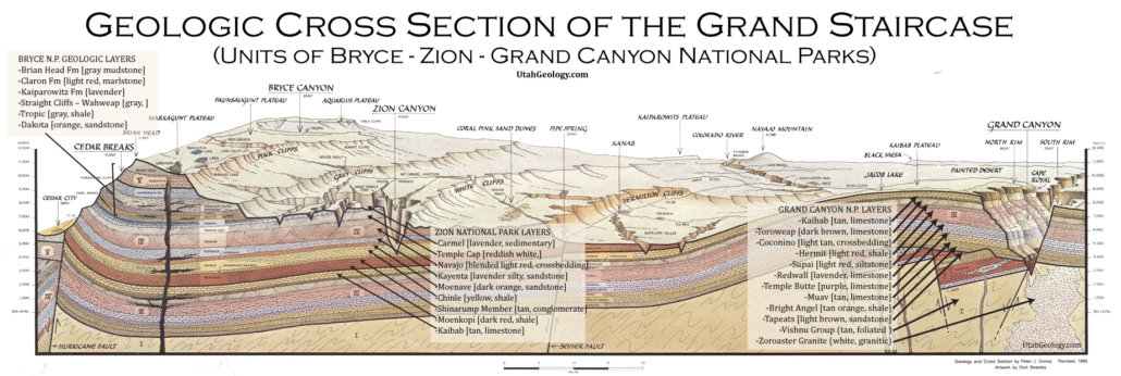
The Navajo is exposed throughout the state of Utah, but reaches maximum thickness near Zion National Park and Red Rocks Recreation area near Las Vegas.
Age: Early Jurassic
The Navajo Sandstone is dated as Early Jurassic, although precise dating is typically difficult due to a lack of age diagnostic fossils, a common problem in eolian deposits.
Depositional Environment: Eolian (wind blown)
The Navajo Sandstone was deposited in an eolian environment composed of large sand dunes, similar to portions of the modern Sahara Desert. In an eolian environment there are two primary types of deposits: 1) dunes, typified by large-scale trough cross stratification; and 2) interdunes, which are the flat lying areas between dunes.
Paleogeography:
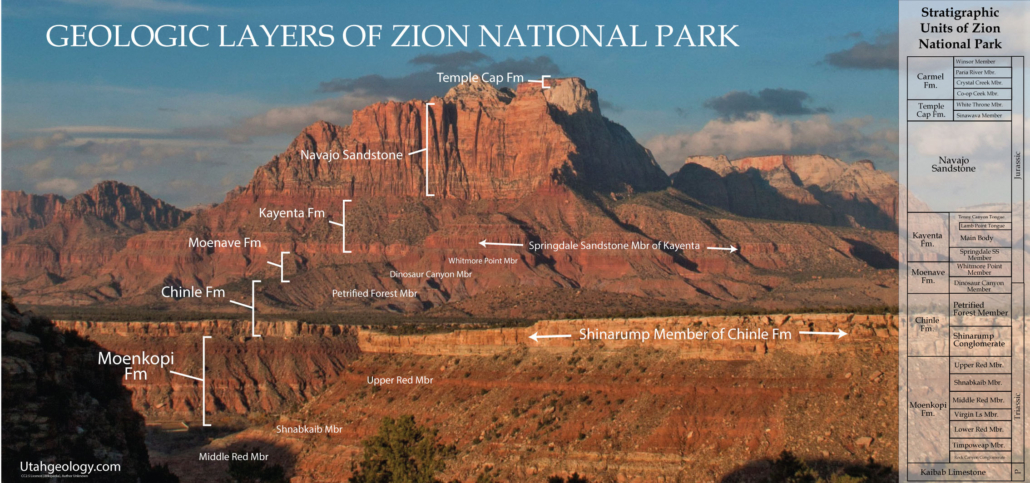
The Navajo Sandstone represents an enormous erg, a large sand sea. This sand sea extended over most of Utah as well as parts of New Mexico, Arizona, Colorado and Wyoming. Though the deposits are known by different names in different areas, they were all a part of this major erg system. At this time, the modern Colorado Plateau region was at very low latitude, approximately 10o north of the equator (Blakey 2008). The Colorado Plateau region was located near the western edge of Laurentia, the western-most portion of North America (not having accreted to the rest of the continent by then). By the Early Jurassic, Pangaea had begun to break up.
Detrital zircon geochronology indicates that the Navajo erg received some sediment from the Appalachian Mountains via a continental scale river system similar to the modern Mississippi River. (Dickinson and Gehrels 2003; Rahl et al.2003) To the south and west of the erg were mountains of the nascent Cordilleran Arc, while to the east lay to the platform of central North America and the remnants of the Ancestral Rocky Mountains. Directly adjacent to the south and west of the erg lay the fluvial facies of the Kayenta Formation.
Tectonics:
Although the Navajo Sandstone was not deformed by the active tectonics, it did form in a basin that was a result of the regional tectonics. As the mountains to the south and west were uplifting a flexural basin was formed from the added mass of the new mountain range. The subsidence of this basin created room for the sand to be deposited in. This also caused deceleration of the regional winds due to a decrease in the pressure gradient, which caused the sand being transported by the wind to be deposited in the erg (Kocurek 2003).
Climate: arid
The climate in the Colorado Plateau region during deposition of the Navajo Sandstone was very dry (classified as hyper-arid). Due to the mechanics of global atmospheric circulation, large desert, such as the Arabian Desert, are typically located around 25-30o north and south of the equator in the trade wind belt. Because of the Navajo location on the western side of the Laurentian landmass, easterly trade winds were very dry by the time that they reached the Colorado Plateau region at approximately 10o north latitude, delivering little rain all to the region (Kocurek and Dott 1983, Loope et al. 2004).
Dunes require strong winds to form. Winter monsoon winds blowing from the northwest seem to be counter to the northeasterly winds typically present at the low latitudes at which the Navajo Sandstone was deposited. Studies of modern low latitude atmospheric circulation shows that low latitude, low-pressure systems can cause monsoon winds that undergo a 900 change in direction as they approach latitudes within 100 of the equator. These observations explain how dune fields formed by northwesterly winds could develop at a latitude where northeasterly winds are expected. During the summer a lighter cross equatorial monsoon wind blew from the southwest modifying the dune shapes (Loope et al. 2004).
Features:
The Navajo Sandstone is most notable for its excellently preserved, large-scale trough cross strata recording lee-face deposition on the subareial sand dunes (Kocurek and Dott 1983). Two types of internal stratification are common in the cross strata: grain flow strata and wind ripple strata. Grain flow strata form as avalanches of sand grains slump down the lee faces of the dunes. They primarily form during periods when the wind is blowing in the dominant dune forming direction. These strata can be recognized most easily by their downslope pinch outs towards the toe of the dune. Wind ripple strata leave thin, inversely graded “pin stripe” laminae, formed by ripples superimposed on the much larger sand dunes. In some cases, wind ripples at the toe of the dune and form aprons or plinths of reworked sand. In Capitol Reef National Park there are two primary eolian deposits, the Navajo Sandstone and the Wingate Sandstone. Since they were formed in the same depositional environment the two formations on might think these should look fairly similar. However, the two formations weather quite differently. The Navajo tends to weather into smooth rounded domes and cliffs, whereas the Wingate tends to from very blocky, vertical cliffs. The Navajo also has a tendency to sometimes have weathered pockets from a process called honeycomb weathering. In general, the Wingate tends to be red in color, and the Navajo is typically more white in the field trip area. This is most likely the result of higher permeability in the Navajo, permitting higher fluid flow and diagenetic bleaching of the rock.
Description:
The Navajo Sandstone is particularly prominent in southern Utah, where it forms the main attractions of a number of national parks and monuments including Arches National Park, Zion National Park, Capitol Reef National Park, Canyonlands National Park,[3] Glen Canyon National Recreation Area,[4] and Grand Staircase–Escalante National Monument.
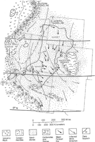
Navajo Sandstone frequently overlies and interfingers with the Kayenta Formation of the Glen Canyon Group. Together, these formations can result in immense vertical cliffs of up to 2,200 feet (670 m). Atop the cliffs, Navajo Sandstone often appears as massive rounded domes and bluffs that are generally white in color.
Navajo Sandstone frequently occurs as spectacular cliffs, cuestas, domes, and bluffs rising from the desert floor. It can be distinguished from adjacent Jurassic sandstones by its white to light pink color, meter-scale cross-bedding, and distinctive rounded weathering.
The wide range of colors exhibited by the Navajo Sandstone reflect a long history of alteration by groundwater and other subsurface fluids over the last 190 million years. The different colors, except for white, are caused by the presence of varying mixtures and amounts of hematite, goethite, and limonite filling the pore space within the quartz sand comprising the Navajo Sandstone. The iron in these strata originally arrived via the erosion of iron-bearing silicate minerals.
Initially, this iron accumulated as iron-oxide coatings, which formed slowly after the sand had been deposited. Later, after having been deeply buried, reducing fluids composed of water and hydrocarbons flowed through the thick red sand which once comprised the Navajo Sandstone. The dissolution of the iron coatings by the reducing fluids bleached large volumes of the Navajo Sandstone a brilliant white. Reducing fluids transported the iron in solution until they mixed with oxidizing groundwater. Where the oxidizing and reducing fluids mixed, the iron precipitated within the Navajo Sandstone.
Depending on local variations within the permeability, porosity, fracturing, and other inherent rock properties of the sandstone, varying mixtures of hematite, goethite, and limonite precipitated within spaces between quartz grains. Variations in the type and proportions of precipitated iron oxides resulted in the different black, brown, crimson, vermillion, orange, salmon, peach, pink, gold, and yellow colors of the Navajo Sandstone.
The precipitation of iron oxides also formed laminae, corrugated layers, columns, and pipes of ironstone within the Navajo Sandstone. Being harder and more resistant to erosion than the surrounding sandstone, the ironstone weathered out as ledges, walls, fins, “flags”, towers, and other minor features, which stick out and above the local landscape in unusual shapes.
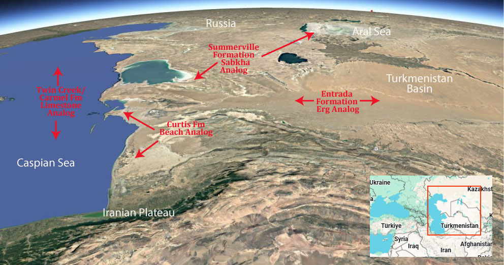
Modern Analog to Utah’s Middle Jurassic
.
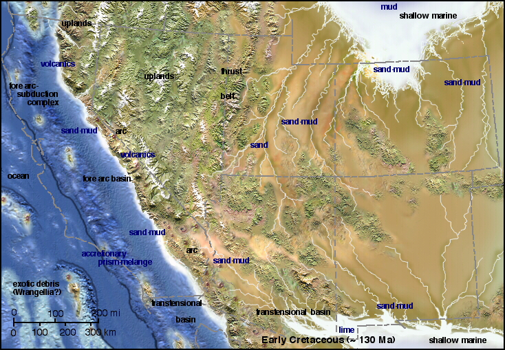
Paleogeography or Depiction of Utah during Middle Jurassic
What is the Grand Staircase?
The Grand Staircase is a unique and extensive exposure of Earth’s history, showcasing over 200 million years of sedimentary rock layers. Geologists often liken these layers to a “book,” allowing for a detailed study of the Earth’s past, including changes in climate and environment.
The major sedimentary rock units exposed in the Grand Canyon range in age from 200 million to 600 million years and were deposited in warm shallow seas and near-shore environments. The nearly 40 identified rock layers of Grand Canyon form one of the most studied geologic columns in the world.

[flickr_tags user_id=”95435349@N04″ randomize=”true” margins=”4″ pagination=”numbers” tags=”navajo” max_num_photos=”9″]
[flickr_tags user_id=”95435349@N04″ tags=”chinle, navajo”]