
• Link to Facebook
  • Link to Instagram
  • Link to Youtube
  • Home
  • Tours
  • About
  • Contact
UtahGeology
  • Guided Tours
  • Hiking Guides
    • Geologic Hiking Guides
  • Geoarchaeology
    • Archaeology Explorer
    • Were the Ice Ages Caused by True Polar Wandering?
  • Geologic History
    • Utah Geologic History
    • Geologic History Overview
    • Geologic History of Utah & the Colorado Plateau
  • Road Guides
    • Utah Geologic Road Guides
    • Road Guides Overview
  • Geologic Formations
    • Geologic Formations
    • Geologic Formations Overview
  • Stratigraphic Columns
    • Utah Stratigraphic Columns
    • Stratigraphic Columns Overview
    • Layer Thickness Map
  • More
    • About
    • Contact
    • Geo Imagery
    • Earthquake Viewer
    • Interactive Map Gallery
    • Whats New?
    • Image & Copyright Policy
    • Web Links
  • Click to open the search input field Click to open the search input field Search
  • Menu Menu
You are here: Home1 / Geologic Formation Pages2 / Esplanade Sandstone & Cutler Cedar Mesa Sandstone (Geology of The Grand...

Esplanade Sandstone & Cutler Cedar Mesa Sandstone (Geology of The Grand Canyon)
May 7, 2025/in Geologic Formation Pages/by Lance Weaver
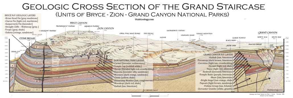
Geologic Cross section of the layers of The Grand Staircase from Bryce through Zion to the Grand Canyon National Parks. Note the Navajo forms the walls of Zion Canyon.

Explore unit thickness in All-in-One App

Grand Staircase Strat Column (Link).

Exposure:

The Esplanade Sandstone is the upper member of the Supai Group and forms a prominent bench visible throughout the Grand Canyon. It is time equivalent to the upper Culter Group units, the Cedar Mesa & Elephant Canyon Formations.

Age:  Early Permian, 290–294 million years ago.

Depositional Environment: deposited in a nearshore eolian, or wind-blown, environment. Specifically, it formed along the western edge of the ancient Pangaean Supercontinent. The Hermit Shale, which sits above the Esplanade, was deposited in a fluvial and coastal plain environment. The Esplanade Sandstone is part of the Supai Group, which generally represents a diverse range of environments, but eolian sands are most prevalent.

Paleogeography: Like most Grand Canyon units, the region was likely the western coast of the North American craton during much of the Paleozoic.

Tectonics: The collision of the Gondwana Plate with the North American Plate resulted in the Uncompahgre highland.

Climate: generally dry, with eolian (wind-blown) environments prevalent

Features: The Esplanade/Cedar Mesa Sandstones are a significant feature of the Grand Canyon & Canyonlands, forming a prominent shelf or terrace about a fourth of the way down from the rim. It’s a resistant sandstone, dark red in color, and plays a crucial role in the canyon’s landscape. This rock unit is a key element in creating a “canyon within a canyon” effect, as the Hermit Formation overlies it, forming the slopes below.

The Esplanade Sandstone is characterized by its cliff-forming nature and resistance to erosion, leading to its distinctive shelf formation. It’s also notable for its origin, formed from desert sand dunes that were subsequently compacted and cemented over long geological timescales. This formation also supports a unique ecosystem, with cyanobacteria, lichens, and mosses thriving on its surface, contributing to the overall biodiversity of the canyon.

The Esplanade Sandstone’s presence is particularly visible at locations like Toroweap Overlook and the east side of the canyon. The Esplanade Route trail, named after the sandstone, further highlights its prominence in the canyon’s landscape. Its resistant nature and distinctive color make it a visually striking and geologically important part of the Grand Canyon’s features.

Similarly, the Cedar Mesa forms a prominent shelf of the Hite region and may be lithologically equivalent as well as time equivalent (research this).

View looking north from Tuweap area near Toroweap Point.
Detailed schematic of the units of the Culter formation. (see full poster at this link).

Description:

The Lower Permian Esplanade Sandstone is a cliff-forming, resistant sandstone, dark red, geologic unit found in the Grand Canyon. The rock unit forms a resistant shelf in the west Grand Canyon, south side of the Colorado River, at the east of the Toroweap Fault, down-dropped to west, southeast of Toroweap Overlook (North Rim, at Lava Falls), and west of Havasupai. The red, sandstone shelf, The Esplanade is about 20-mi long. At Toroweap Overlook region, Toroweap Valley with Vulcan’s Throne, Uinkaret volcanic field, the resistant Esplanade Sandstone is described in access routes exploring the Toroweap Lake area (Hike 17, Vulcans Throne).[2]

The Esplanade Route–(trail), of the east Grand Canyon is also named for the Esplanade Sandstone. The coeval sandstone geologic unit from eastern Utah is the Cedar Mesa Sandstone

The Supai Group members were created from marine (oceanic) sequences of marine transgression, and regression, thus the alternating sandstone, siltstones, conglomerate subsections (facies); the subsections are not always a continuous transition into the above section, mostly due to ocean levels, falling, or rising, glaciation, or regional subsidence–(basins, etc.) or uplift of land. Today’s Wasatch Front is the approximate lineage, NNE to SSW of the western coast region of North America from where the oceans transgressed. The ancient Antler Mountains–(Antler orogeny, off-shore volcanic island arch(es)), of ancient Nevada supplied material, from the west, off the ‘ancestral’ West Coast. The continent supplied material from the east, both directions supplying the offshore basin, the Cordilleran Basin which became part of the Basin and Range Province, in later epochs. Three other basins were involved in this history: southwest of the Ancestral Rocky Mountains was the Paradox Basin–(eastern Utah to Southwest Colorado), northeast was the Central Colorado Basin–(NW Colorado, NE Utah, SW Wyoming); the Oquirrh Basin was north-northwest, at present day northwest Utah.

Modern Analog to Utah’s Middle Jurassic
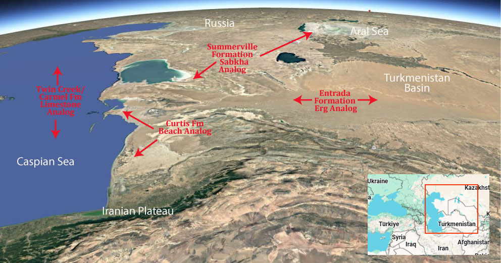
Trade this out with the Indus Delta!

.

Paleogeography or Depiction of Utah during Middle Jurassic

What is the Grand Staircase?

The Grand Staircase is a unique and extensive exposure of Earth’s history, showcasing over 200 million years of sedimentary rock layers. Geologists often liken these layers to a “book,” allowing for a detailed study of the Earth’s past, including changes in climate and environment.

The major sedimentary rock units exposed in the Grand Canyon range in age from 200 million to 600 million years and were deposited in warm shallow seas and near-shore environments. The nearly 40 identified rock layers of Grand Canyon form one of the most studied geologic columns in the world.

[flickr_tags user_id=”95435349@N04″ randomize=”true” margins=”4″ pagination=”numbers” tags=”navajo” max_num_photos=”9″]

[flickr_tags user_id=”95435349@N04″ tags=”chinle, navajo”]
Tags: cutler, esplanade, formations, geology
Share this entry
  • Share on Facebook
  • Share on X
  • Share on WhatsApp
  • Share on Pinterest
  • Share on LinkedIn
  • Share on Tumblr
  • Share on Vk
  • Share on Reddit
  • Share by Mail
https://utahgeology.com/wp-content/uploads/2025/07/utah-geology-site-logo-420px-new.png 0 0 Lance Weaver https://utahgeology.com/wp-content/uploads/2025/07/utah-geology-site-logo-420px-new.png Lance Weaver2025-05-07 04:56:532026-03-10 23:37:26Esplanade Sandstone & Cutler Cedar Mesa Sandstone (Geology of The Grand Canyon)
You might also like
Morrison Formation (Geology of Utah’s Grand Staircase)
Is the Orbit of Jupiter related to Solar Cycles and How Gravity Waves & Electrical Properties Affect the Earth and Shape the Arms of the Milky Way Galaxy
Grand Canyon’s Tapeats Sandstone (Geology of The Grand Staircase)
Grand Canyon’s Bright Angel Shale (Geology of The Grand Staircase)
Moenkopi Formation (Geology of Utah’s Grand Staircase)
Curtis Formation (Geology of Utah’s Grand Staircase)

Welcome

About me
Lance Weaver. about me.


Book a Tour

Popular
  • Tracks, Traces & Other Fossils of The Grand Canyon &...January 7, 2025 -
  • When Was The Colorado River Formed?February 21, 2025 -
  • Were the Ice Ages Caused by True Polar Wandering?September 21, 2020 -
  • Navajo SandstoneApril 16, 2015 -
  • The Vishnu SchistNovember 14, 2018 -
  • Take Away Lessons from my Experience with the Jerold Williams...August 10, 2015 -
  • The Geology of Zion National ParkNovember 14, 2018 -
  • Utah’s Three Types of VolcanoesMay 26, 2015 -
  • Grand Canyon’s Bright Angel Shale (Geology of The...March 10, 2026 -
Recent
  • When Was The Colorado River Formed?February 21, 2025 -
  • Tracks, Traces & Other Fossils of The Grand Canyon &...January 7, 2025 -
  • Grand Canyon’s Bright Angel Shale (Geology of The...March 10, 2026 -
  • Grand Canyon’s Tapeats Sandstone (Geology of The...March 10, 2026 -
  • Grand Canyon’s Muav Limestone (Geology of The Grand...March 7, 2026 -
  • Grand Canyon’s Redwall Limestone (Geology of The...March 7, 2026 -
  • The Cretaceous (Cretassic) Period: A Geologic Proposition...March 2, 2026 -
  • A Geologic Overview of Lake Powell, UtahFebruary 15, 2026 -
  • Pine Park and the Ancient Supervolcanoes of Southwestern...February 15, 2026 -
  • The Weaver Precessional Polar Oscillation Cycle & Core-Mantle...January 3, 2026 -
Comments
  • Lance WeaverIf you want to visit some of these formations check out...May 11, 2026 - by Lance Weaver
  • Mads Erik HusdalThe amount of work you have put in this is mind boggling!...February 23, 2026 - by Mads Erik Husdal
  • Gabor Szuecs dr.Because the pole was not where it is today. Around the year...February 8, 2026 - by Gabor Szuecs dr.
  • Alan FullerUpdate to previous post. After a more thorough read I have...December 30, 2025 - by Alan Fuller
  • Alan FullerFantastic piece of work I think you have basically described...December 26, 2025 - by Alan Fuller
  • Lance WeaverNo. Despite what some say, there are no specific 'angles'...November 21, 2025 - by Lance Weaver
  • Mark RademakerLance, i have read that the cross beds of Checkerboard Mesa...November 9, 2025 - by Mark Rademaker
  • Mark RademakerLance, have you dug into Dr. John Whitmore's material in...November 9, 2025 - by Mark Rademaker

Follow us on Facebook

UtahGeology
Logo image
Go to facebook page
Join the Facebook community!

Tag Cloud

Frontpage Article Geoarchaeology Geologic Formation Pages Geologic Hiking Guides Images News Uncategorized

Important Pages

Privacy Policy,    About utahgeology.com,    Contact Us,   
Image & Copyright Policy

Relevant Links

  • Utah Geological Survey
  • U.S. Geological Survey
  • Arizona Geology Blog
  • Durango Bill
  • Zion Experiences

Contact Me

Utahgeology is a 501c nonprofit. If you would like to contact me, drop me a line from the contact page. Or if you have questions about geology, call me during normal work hours at the Utah Geological Survey.
© Copyright - UtahGeology - Enfold Theme by Kriesi
  • Link to Facebook
  • Link to Instagram
  • Link to Youtube
Link to: Hermit/Organ Rock (Geology of The Grand Canyon) Link to: Hermit/Organ Rock (Geology of The Grand Canyon) Hermit/Organ Rock (Geology of The Grand Canyon)Link to: Supai & Hermosa Group / Weber Sandstone (Geology of The Grand Staircase) Link to: Supai & Hermosa Group / Weber Sandstone (Geology of The Grand Staircase) Supai & Hermosa Group / Weber Sandstone (Geology of The Grand Staircas...
Scroll to top Scroll to top Scroll to top