
• Link to Facebook
  • Link to Instagram
  • Link to Youtube
  • Home
  • Tours
  • About
  • Contact
UtahGeology
  • Guided Tours
  • Hiking Guides
    • Geologic Hiking Guides
  • Geoarchaeology
    • Archaeology Explorer
    • Were the Ice Ages Caused by True Polar Wandering?
  • Geologic History
    • Utah Geologic History
    • Geologic History Overview
    • Geologic History of Utah & the Colorado Plateau
  • Road Guides
    • Utah Geologic Road Guides
    • Road Guides Overview
  • Geologic Formations
    • Geologic Formations
    • Geologic Formations Overview
  • Stratigraphic Columns
    • Utah Stratigraphic Columns
    • Stratigraphic Columns Overview
    • Layer Thickness Map
  • More
    • About
    • Contact
    • Geo Imagery
    • Earthquake Viewer
    • Interactive Map Gallery
    • Whats New?
    • Image & Copyright Policy
    • Web Links
  • Click to open the search input field Click to open the search input field Search
  • Menu Menu
You are here: Home1 / Geologic Formation Pages2 / Entrada Formation (Geology of Utah’s Grand Staircase)

Entrada Formation (Geology of Utah’s Grand Staircase)
April 25, 2025/in Geologic Formation Pages/by Lance Weaver
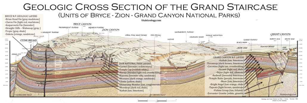
Geologic Cross section of the layers of The Grand Staircase from Bryce through Zion to the Grand Canyon National Parks. Note the Entrada is absent in Zion but sits atop the Carmel Fm.

Explore unit thickness in All-in-One App

Exposure:

Without a doubt the most striking exposures of the Entrada Formation are in Arches National Park. Other great exposures exist in Canyonlands, Goblin Valley State Park and Lake Powell NRA.

Age:  Upper Jurassic, 80 and 140 ma

Depositional Environment: Eolian, sabkha, and tidal flat. The Entrada Sandstone preserves terrestrial environments.  Within the field trip area, the deposits generally indicate a high water table with some dunes (wet eolian) present.  The bedding contains sandstone laminations, sand lenses with some lenses starved and encased in mud.  This environment is broadly interpreted as a tidal regime (tidal flat) in this region.

Paleogeography:

In the Upper Jurassic, the supercontinent, Pangea, was beginning to break up with North American and Eurasia pulling apart from South America.  Utah was closer to the equator with eastern Utah as a dry Sahara-like desert, with shallow seas that intermittently covered the area (Blakey 2008).

At around 170 Ma, the Goblin Valley State Park area was a wide tidal flat between the sea to the north and continental mountains and hills to the west.  Tidal channels migrated across the tidal flats, routing flowing water to the open sea. Coastal sand dunes also covered parts of the tidal flats.  Oscillatory tide motions were a dominant force in the deposition of this area.  Silts, sands, and clays were primarily sourced from erosional debris shed from granitic highlands of Northwestern Utah and then were re-deposited in seas, shorelines, river channels, and playas.

Tectonics:

Goblin Valley State Park is near the edge of a regional system of faults that cut across the San Rafael Swell (Fillmore 2000, Milligan 2003).  Several sets of microfaults divide the Entrada Sandstone into yard sized rhombohedral blocks. The blocks exhibit reduced grain size, decreasing porosity and permeability within the fractures. In Goblin Valley only small-scale fractures with small offsets may be visible.

Climate: warm and arid

Features:

The dark reddish color of the Entrada Sandstones comes mainly from the mineral hematite (an iron oxide and principal ore of iron) staining the sandstone.  This is the same formation that makes up the natural arches of Arches National Park in southeastern Utah.  A synthesis of the Entrada Sandstone is given in Carr and Kocurek (1993).

Joint or fracture patterns in the Entrada Sandstone create initial weak zones that become enlarged over time. Joints intersections are susceptible to weathering because of increased surface to area volume ratio.  These joints weather quickly, creating spherical-shaped goblins, from spheroidal weathering (Milligan 2003).  Interbedded and underlying shale and siltstone beds are capped by the sandstone beds. The soft shale and siltstone beds help create the smooth shaped pedestals in Goblin Valley State Park.
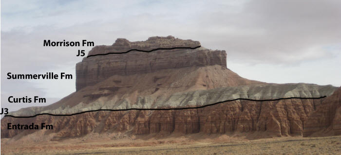
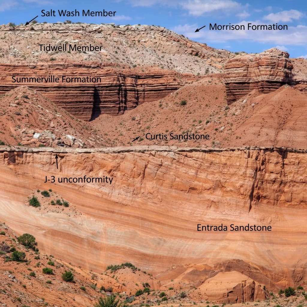
View of the Morrison Formation, the Summerville Formation, the Curtis Formation, and the Entrada Formation.

Description:

At its type section at Entrada Point, located in the northern part the San Rafael Swell in Emery County, Utah,[4] the Entrada consists of red silty sandstone and lesser interbedded mudstone and is a slope-forming formation. This part of the Entrada is sometimes described as the “earthy facies”.[5] Here the Entrada is overlain by the Curtis Formation, and overlies the Carmel Formation.[4] To the south and east, the Entrada transitions to cliff-forming red or white crossbedded sandstone, sometimes called the “slickrock facies”. This is actually more typical of the Entrada as a whole, and a principal reference section including both facies was designated by Peterson in 1988 at Pine Creek, 5 kilometers (3.1 mi) north of Escalante, Utah, in the Kaiparowits Basin.[5]

At the reference section in the Kaiparowitz Basin, the Entrada is 314 meters (1,030 ft) thick and is divided into three informal members. The lower member is 113 meters (371 ft) of orange-red silty sandstone, with occasional beds of red mudstone, corresponding to the earthy facies. The middle member is 132 meters (433 ft) of red to green mudstone interbedded with red to white sandstone. The upper member is 69 meters (226 ft) of crossbedded white sandstone.[6] The white color is attributed to bleaching by organic-rich fluids from overlying beds. The formation rests on the Carmel Formation and is overlain by the Morrison Formation.[7]

In the Curtis Mountains region of northeastern Arizona, the Entrada is overlain by the Wanakah Formation.[8]

In the San Juan Basin of northwestern New Mexico, the Entrada consists of upper and lower sandy members and a medial silty member, the Rehoboth Member. The Curtis Formation is sometimes absent and the Entrada then overlies Chinle Formation. It is overlain by the Todilto Formation. Southeast of Fort Defiance, Arizona, the lower sandy beds are assigned to the Iyanbito Member. Total thickness is up to 37 meters (121 ft).[8]

In the Slick Rock, Colorado area, the Entrada is divided into a “middle sandstone”, the Rehoboth Member, and the Slick Rock Member, in ascending order

Modern Analog to Utah’s Middle Jurassic
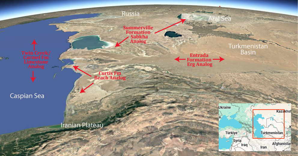
Many modern analogs have been proposed for the desert ergs, sabkha’s and limestone’s of Utah’s Middle Jurassic, but we favor Africa & the Turkmenistan/Caspian Basin as it includes all the depositional environments found for this geologic period.

.

Paleogeography or Depiction of Utah during Middle Jurassic
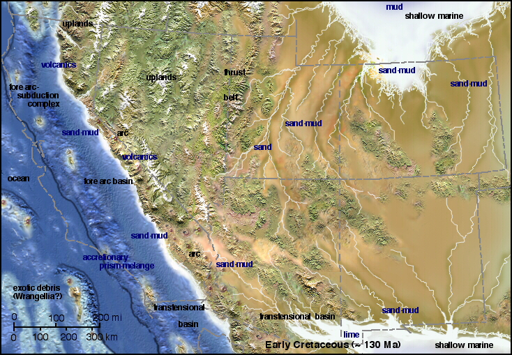
Figure 1: Paleogeographic map of the Middle Jurassic, Page Sandstone, Carmel Formation, Entrada Sandstone, Curtis Formation, and Summerville Formation. (Blakey, 2008)

What is the Grand Staircase?

The Grand Staircase is a unique and extensive exposure of Earth’s history, showcasing over 200 million years of sedimentary rock layers. Geologists often liken these layers to a “book,” allowing for a detailed study of the Earth’s past, including changes in climate and environment.

The major sedimentary rock units exposed in the Grand Canyon range in age from 200 million to 600 million years and were deposited in warm shallow seas and near-shore environments. The nearly 40 identified rock layers of Grand Canyon form one of the most studied geologic columns in the world.

[flickr_tags user_id=”95435349@N04″ randomize=”true” margins=”4″ pagination=”numbers” tags=”navajo” max_num_photos=”9″]

[flickr_tags user_id=”95435349@N04″ tags=”chinle, navajo”]

Tags: entrada, formations, geology
Share this entry
  • Share on Facebook
  • Share on X
  • Share on WhatsApp
  • Share on Pinterest
  • Share on LinkedIn
  • Share on Tumblr
  • Share on Vk
  • Share on Reddit
  • Share by Mail
https://utahgeology.com/wp-content/uploads/2025/07/utah-geology-site-logo-420px-new.png 0 0 Lance Weaver https://utahgeology.com/wp-content/uploads/2025/07/utah-geology-site-logo-420px-new.png Lance Weaver2025-04-25 04:14:122026-04-26 17:25:26Entrada Formation (Geology of Utah’s Grand Staircase)
You might also like
Summerville Formation (Geology of Utah’s Grand Staircase)
Esplanade Sandstone & Cutler Cedar Mesa Sandstone (Geology of The Grand Canyon)
Grand Canyon’s Bright Angel Shale (Geology of The Grand Staircase)
Moenkopi Formation (Geology of Utah’s Grand Staircase)
Curtis Formation (Geology of Utah’s Grand Staircase)
Supai & Hermosa Group / Weber Sandstone (Geology of The Grand Staircase)

Welcome

About me
Lance Weaver. about me.


Book a Tour

Popular
  • Tracks, Traces & Other Fossils of The Grand Canyon &...January 7, 2025 -
  • When Was The Colorado River Formed?February 21, 2025 -
  • Were the Ice Ages Caused by True Polar Wandering?September 21, 2020 -
  • Navajo SandstoneApril 16, 2015 -
  • The Vishnu SchistNovember 14, 2018 -
  • Take Away Lessons from my Experience with the Jerold Williams...August 10, 2015 -
  • The Geology of Zion National ParkNovember 14, 2018 -
  • Utah’s Three Types of VolcanoesMay 26, 2015 -
  • Grand Canyon’s Bright Angel Shale (Geology of The...March 10, 2026 -
Recent
  • When Was The Colorado River Formed?February 21, 2025 -
  • Tracks, Traces & Other Fossils of The Grand Canyon &...January 7, 2025 -
  • Grand Canyon’s Bright Angel Shale (Geology of The...March 10, 2026 -
  • Grand Canyon’s Tapeats Sandstone (Geology of The...March 10, 2026 -
  • Grand Canyon’s Muav Limestone (Geology of The Grand...March 7, 2026 -
  • Grand Canyon’s Redwall Limestone (Geology of The...March 7, 2026 -
  • The Cretaceous (Cretassic) Period: A Geologic Proposition...March 2, 2026 -
  • A Geologic Overview of Lake Powell, UtahFebruary 15, 2026 -
  • Pine Park and the Ancient Supervolcanoes of Southwestern...February 15, 2026 -
  • The Weaver Precessional Polar Oscillation Cycle & Core-Mantle...January 3, 2026 -
Comments
  • Lance WeaverIf you want to visit some of these formations check out...May 11, 2026 - by Lance Weaver
  • Mads Erik HusdalThe amount of work you have put in this is mind boggling!...February 23, 2026 - by Mads Erik Husdal
  • Gabor Szuecs dr.Because the pole was not where it is today. Around the year...February 8, 2026 - by Gabor Szuecs dr.
  • Alan FullerUpdate to previous post. After a more thorough read I have...December 30, 2025 - by Alan Fuller
  • Alan FullerFantastic piece of work I think you have basically described...December 26, 2025 - by Alan Fuller
  • Lance WeaverNo. Despite what some say, there are no specific 'angles'...November 21, 2025 - by Lance Weaver
  • Mark RademakerLance, i have read that the cross beds of Checkerboard Mesa...November 9, 2025 - by Mark Rademaker
  • Mark RademakerLance, have you dug into Dr. John Whitmore's material in...November 9, 2025 - by Mark Rademaker

Follow us on Facebook

UtahGeology
Logo image
Go to facebook page
Join the Facebook community!

Tag Cloud

Frontpage Article Geoarchaeology Geologic Formation Pages Geologic Hiking Guides Images News Uncategorized

Important Pages

Privacy Policy,    About utahgeology.com,    Contact Us,   
Image & Copyright Policy

Relevant Links

  • Utah Geological Survey
  • U.S. Geological Survey
  • Arizona Geology Blog
  • Durango Bill
  • Zion Experiences

Contact Me

Utahgeology is a 501c nonprofit. If you would like to contact me, drop me a line from the contact page. Or if you have questions about geology, call me during normal work hours at the Utah Geological Survey.
© Copyright - UtahGeology - Enfold Theme by Kriesi
  • Link to Facebook
  • Link to Instagram
  • Link to Youtube
Link to: Curtis Formation (Geology of Utah’s Grand Staircase) Link to: Curtis Formation (Geology of Utah’s Grand Staircase) Curtis Formation (Geology of Utah’s Grand Staircase)Link to: Carmel Formation (Geology of Utah’s Grand Staircase) Link to: Carmel Formation (Geology of Utah’s Grand Staircase) Carmel Formation (Geology of Utah’s Grand Staircase)
Scroll to top Scroll to top Scroll to top
