
The Kolob Canyons Trifecta: Icebox, Sweatbox & Glovebox Canyoneering- The Timber Creek Loops
.
Part 1: Icebox Canyon (aka Waterfalls Canyon)
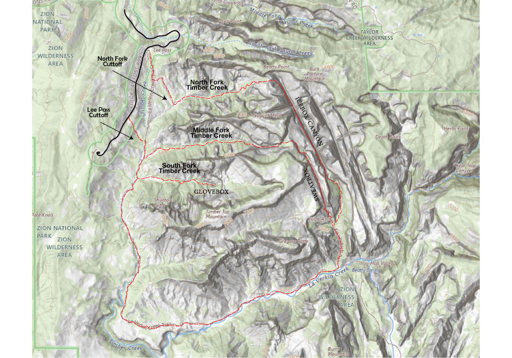
Icebox is the one canyon of the three with published betas. It’s tucked behind Timber Top Mountain and Nagunt Mesa, and the route climbs a brushy ridge out of Timber Creek, drops over a slickrock pass into a lush, spring-fed canyon, and finishes at a huge triple waterfall just above the Kolob Arch viewpoint. From there you take the trail back to Lee Pass. Below is my summary of the existing beta; the sources are credited at the end.
Quick Facts
| Rating | North Pass entry: 3B IV (Ropewiki lists v3a2 IV; BluuGnome lists 3B III (IV)). Slickrock Pass entry: 4B IV |
| Distance | 12.4–15 miles round trip (12.4 RTR, 13 BluuGnome, 15 Ropewiki). The technical section itself is about 2.9 miles |
| Time | 8–15 hours. Fast, fit groups take 8–10 hours; slow or less-skilled groups often take 14+ |
| Elevation | Roughly 6,960 ft at North Pass down to 5,050 ft along La Verkin Creek. About 2,000 ft of total gain, including an 800–1,000 ft climb on the hike out |
| Rappels | 5 to 9, depending on entry and how much you downclimb. Longest is 160–165 ft (50 m) |
| Permit | Required (Zion wilderness/canyoneering permit) |
| Season | Late spring, summer, and fall. The hike out can be brutally hot in summer |
| Flash flood risk | Moderate. The collection zone is small and visible, and only short sections of slot present a risk |
| Water | A trickle runs even in drought. You’ll hit a few pools and at least one swim of about 100 ft. Filterable water starts about halfway through the day, but carry plenty for the dry approach |
| Wetsuit | Not needed in hot weather. Bring a wetsuit or drysuit in cool weather, and a dry bag either way |
| Rope | A rope and pull-cord system that can handle a 165 ft (50 m) rappel. BluuGnome got by with gear for raps up to 150 ft on the North Pass entry. Road Trip Ryan lists rappels up to 60 m (197 ft) if you rap the entry couloir rather than downclimbing it |
| Gear | Helmets, rappel gear, about 70 ft of 1-inch webbing, rapid links, and a dry bag. Be ready to build or back up anchors |
| Shuttle | None. It’s a loop from Lee Pass |
Approach (about 3 miles; roughly 2 hours for a fast group)
There are actually TWO approaches to get into North Fork of Timber Creek. You can either take the Lee pass trail all the way to the Timber Creek drainage and backtrack. OR you can bushwack your way through to a shortcut (highly perferred!) If you find the right drainage its smooth sailing after a short 200 yard bushwacky traverse. If you drop into the wrong drainage (south of the correct one), you’ll know because its a bushwack all the way down even though it dumps you in the same place.
- Scout it from the road first. Drive about ¼–½ mile past the Lee Pass Trailhead (3.6–3.7 miles past the Kolob Canyons Visitor Center) and look at the area between Beatty Point and Nagunt Mesa. The wooded ridge and dirt landslide on the left lead to a V-notch, North Pass. The slickrock notch to its right is Slickrock Pass (the “south” entry).
- Lee Pass to Timber Creek. Hike the cuttoff or just take the La Verkin Creek Trail about 1 mile to where it drops into and crosses a deep wash. Leave the trail and go left down the wash for 30 yards or so to the main Timber Creek drainage. Turn left and backtrack upstream.
- Up Timber Creek (about 1.5 miles). It’s overgrown and bushwhacky, with social trails that come and go. Stay toward the canyon bottom, especially higher up, so you aren’t fighting brushy side slopes. You’ll pass a huge fallen boulder. Near the head of the canyon the drainage forks, with a big vertical dryfall a minute up the left (north) fork.
- Up the ridge. Climb the dirt between the two forks to the base of the cliff and an alcove. At the right end, scramble up a short cliff band (about 10 ft) to the steep, vegetated slopes above. Then grind up the wooded ridge and dirt landslide; an emerging use trail helps a little. Near the top, both passes come into view: the gentle trough-shaped saddle on the right is Slickrock Pass, and the one on the left is North Pass.
The Descent
Option A: North Pass entry (3B IV), the more moderate start
North Pass drops into a wide slickrock couloir that rounds over and steepens as you go. Single bolts are scattered along it at odd intervals; they’re hard to find and mostly optional. How many of these upper anchors you use depends on comfort level and conditions, which is why the sources count the entry rappels anywhere from 2 to 5.
| # | Anchor | Height | Notes |
|---|---|---|---|
| Optional | Single bolts (one with an old homemade hanger) | — | Walkable or downclimbable in dry conditions. Crab-walk the steeper bits. RTR suggests a first rap from a lone bolt about 148 ft below the pass, and a second about 181 ft lower to a 2-bolt ledge |
| E1 | 2 bolts on a small ledge | ~83–90 ft (traverse) | More of a traversing handline down and right to a pine on a ledge. A fall here means a pendulum tumble, so be careful |
| E2 | Pine tree | 115–160 ft | Starts sloped, then goes vertical, landing on a ledge for 2–3 people with several bolts. (BluuGnome ~120, RTR ~115, Tom Jones/Ropewiki 160) |
| E3 | 3 bolts on the ledge | 140–165 ft | To the canyon floor. (Tom Jones/Ropewiki 140, BluuGnome ~150, RTR ~165) |
Option B: Slickrock Pass entry (4B IV), a big-wall start for experts only
Climb about halfway up the wooded ridge, then work over to the slickrock below Slickrock Pass. Over the pass, a short 5.2 slab leads to a slanted corridor. Some 4th-class downclimbing gets you to the top of a slab above a big dropoff, where a single bolt can be used for a handline to the first anchor. The rappels go station to station and two of the stations hang, so this is not suitable for parties larger than 2.
| # | Anchor | Height | Notes |
|---|---|---|---|
| E1 | 2 bolts + piton | 160 ft | To a hanging station on a steep wall |
| E2 | 3 bolts | 164 ft | To a hanging station |
| E3 | 3 bolts + piton | 140 ft | To the main canyon floor |
In the canyon (both entries)
From the floor of the main canyon, head downstream through ferns and lush vegetation, with plenty of scrambling and some bushwhacking. A trickle of water soon appears. Side slots come in from both sides and are worth a few minutes of poking around. BluuGnome upclimbed 300–400 ft into one from the west.
The sources number these differently, so this table lines them up by feature:
| # | Feature / anchor | Height | Notes |
|---|---|---|---|
| R1 | Drop into a slot with a pool; 2 bolts on a ledge, right side going downcanyon (DCR) | ~50 ft (15 m) | Traverse right to the anchor and do a diagonal, traversing rappel to avoid the swim. The anchor ledge is slippery when the walls are seeping |
| — | Narrow section | — | Downclimb to a pool and swim briefly, or walk a ledge about a foot underwater on the right |
| R2 | Log jam / very old single bolt with no hanger (RTR: poor anchor) | 10–23 ft | Drops into a narrow, cold, water-filled slot, with a swim of about 100 ft. You can stem it and get wet only to the knees, but plan to swim. Tall, skilled people can downclimb it. (BluuGnome ~10, Ropewiki 15, RTR 23) |
| — | Rockfall, spring-fed pool, log-choked slot | — | Climb over the rockfall, then pass the spring-fed pool on the right. Bypass the deep, debris-filled slot on the wide ledge system on the right (about 400 ft) |
| R3 | Bench on the right, ending in a single old bolt (BluuGnome, RTR) or 2 bolts on a ledge (Ropewiki) | 30–85 ft | The “third obstacle.” Tom Jones says the swim is avoided by “a long hike out” on the right to a bolt anchor. (BluuGnome ~30, RTR 33, Ropewiki 85 to a beach by a large pool). Inspect this anchor carefully. RTR notes you can instead stay in the bottom and do two short rappels |
| R4 | Tree, after traversing a ledge on the right around a large rock bowl | 60 ft | Ropewiki only. You can also hike around the other side of the bowl and downclimb |
| — | Boulder field, then the top of the waterfall | — | A fabulous view from the top of the triple waterfall, a roughly 400 ft (120 m) system of trough-shaped, spring-fed falls. The first trough is worth exploring |
| R5 | Tree, left side going downcanyon (DCL) | 150–160 ft | Bypass the first fall by going left onto the ridge and down to the top of the second trough fall, then rap the mostly vertical wall. You can split it into two stages (100 + 60 ft). (BluuGnome ~150, Ropewiki 160) |
| — | 8 ft drop on the right wall | ~8 ft | Do an aggressive partner assist, or rap from a small tree a little way back |
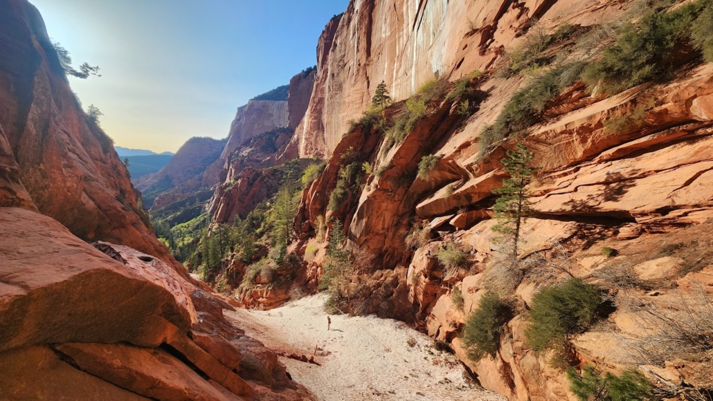
No-rappel waterfall bypass: RTR and Tom Jones skip R5. A couple of minutes below the final pool, a cairn marks an escape up a steep dirt slope on the left. Follow a vague social trail over the adjacent ridge and down the gully on the other side to the canyon floor below the waterfall. Route-finding is a little tricky; stay left.
From there, scramble about ½ mile down the canyon (you may get wet, so keep wetsuits on) until the Kolob Arch Trail and viewpoint appear. The arch is visible to the west/right.
Key Hazards
- Bushwhacking. It’s heavy on the Timber Creek approach and the ridge, and in spots inside the canyon. This is the main complaint in every report.
- Anchors. Several mid-canyon bolts were in poor condition as of 2015. Two of the Slickrock stations rely partly on pitons, and the R2 and R3 bolts are old singles. Bring webbing and rapid links and be ready to build anchors.
- Exposure on the North Pass entry. The slickrock couloir steepens gradually, and the traversing handline to the pine can turn a slip into a pendulum fall.
- Cold water. Expect at least one forced swim (about 100 ft) in a shaded slot, plus slippery seeps at the first in-canyon anchor. Wear a wetsuit when it’s cool.
- Commitment and length. None of the sources describe an escape between the entry rappels and the waterfall. The first real exit is the waterfall bypass. Start early; slow groups take 14+ hours.
- Heat. The 6–7 mile hike out is mostly in full sun and can be brutal in summer.
- The waterfall. The finish is a roughly 400 ft triple waterfall. Either rap the second trough from the tree, or take the cairned bypass on the left. Don’t improvise a line down the falls.
- Flash flood. Moderate risk. Check the forecast before you commit.
Exit: Kolob Arch to Lee Pass (about 6–7 miles)
From the Kolob Arch viewpoint, follow the spur trail about 0.5 miles down to the La Verkin Creek Trail junction. Turn right (southwest) on the La Verkin Creek Trail. After about 1.8 miles you reach a nice spot right on the creek for a break. About 1.1 miles past that is Camp Site 3, where the trail turns north up Timber Creek. From there it’s about 3.4 miles back up to Lee Pass. Allow 2.5–3 hours, with 800–1,000 ft of climbing at the end of a long day.
Overnight option: Road Trip Ryan suggests getting a La Verkin Creek camping permit (sites 6 through 10 or 11) and turning Icebox into a light overnight backpack, which also lets you explore up La Verkin Creek. Tom Jones disagrees: carrying bivy gear up that ridge and down the rappels is “a lot of work, and not recommended.” Pick your poison.
Part 2: Sweatbox, the Middle Fork of Timber Creek Loop
Icebox gets the guidebook ink, but it isn’t the only fork of Timber Creek worth exploring. The other two forks run right alongside it, and as far as I can tell nobody has published beta for either one. They don’t have names on the USGS topo, so I’ve been calling them Sweatbox and Glovebox.
Quick Facts
| Rating | Probably: 3B IV, Maybe 4B IV |
| Distance | If taking the Lee Pass cutoff, 11 miles on map, but with the back& forth of bushwacking, plan on 13-15. |
| Rope | Largest of 6 rapels is about 80-100 ft, so bring 200+ ft rope. Webbing! |
| Time | Plan on at least 8-10 hours (fast), up to 14 hours. Bushwacking takes up lots of time, as does the 0.5 miles of rapels. |
| Wetsuit | Only one short (sometimes dry or gross) pluge pool. Good climbers can easily stem accross. |
| Flash Flood Risk | Very low. Even narrow spots have tiny watersheds/tons of vegitation. |
Approach (about the Lee Pass Cutoff)
There are two options to get into Middle Fork. The first is the tradtional Lee Pass trailhead. But many prefer the Lee Pass cutoff. This bushwack has two advantanges. First, with the increasing popularity of the Kolob Canyons section of Zion, the park service woefully undersized the Lee Pass trailhead parking area which is often full. The cutoff allows for parking in the scenic pullout 0.6 miles down the road from the traditional trailhead parking lot. Second, some prefer a short but steap 0.3 mile drop/rise in & out of Timber Creek verses the drawn out 1.2 mile up and down of the traditional route. Honestly, I wish the Park Service would build a trail heading down and north from the Kolob Viewpoint (end of the road), to accomidate more parking and save 1.8 miles on the Lee pass trail. At any rate, the cuttoff descends the middle of the ridge exactly 0.15 miles down the road from the afore mentioned viewpoint (with the benches and split rock on its south end). Some also choose the bottom of the drainage just south of this ridge. Be warned, its steep and bushwacky and will certainly never gain much popularity as is.
Sweatbox: Middle Fork of Timber Creek / Kolob Arch Loop
Sweatbox is the middle fork of Timber Creek. It runs parallel to Icebox and, like Icebox, comes out on the Kolob Arch Trail, so the hike out to La Verkin Creek and Lee Pass is the same. It rewards hikers with one of the most breathtaking views in Kolob Canyons, but until it gets a little more traffic, its a serious bushwack. Be prpared for hacking your way through a maple, oak and pine forest in central Middle Fork, that feels a lot like pioneering a route through the Northwest or Upstate New York.
It’s best accessed from the Lee’s Pass cutoff, because the up & down climbing nature of the last mile of Lee Pass sucks a duck and whoever made the trail should be flogged.
Similiar to South Fork of Timber Creek or going back into Kolob Arch/ La Verking Creek, I suggest taking the Lee Pass cutoff, which dumps you onto the Lee Pass trail and shaves about 3/4 mile off the approach by taking a steep direct entrance-exit instead the grueling and retarded up and down climb on the last mile of the Lee Pass Trail.
From the confluence of the cutoff hike down the Lee Pass trail aproximately 0.25 miles until you cross Middle Fork of Timber Creek.
NOTE, IT IS INCREDIBLY EASY TO MISS. If you dont have a GPS, you will almost certainly mistake the crossing for just another crossing of the main fork of Timber Creek and not catch the mistake until you get another 0.25 miles down stream and see South Fork of Timber creek come in.
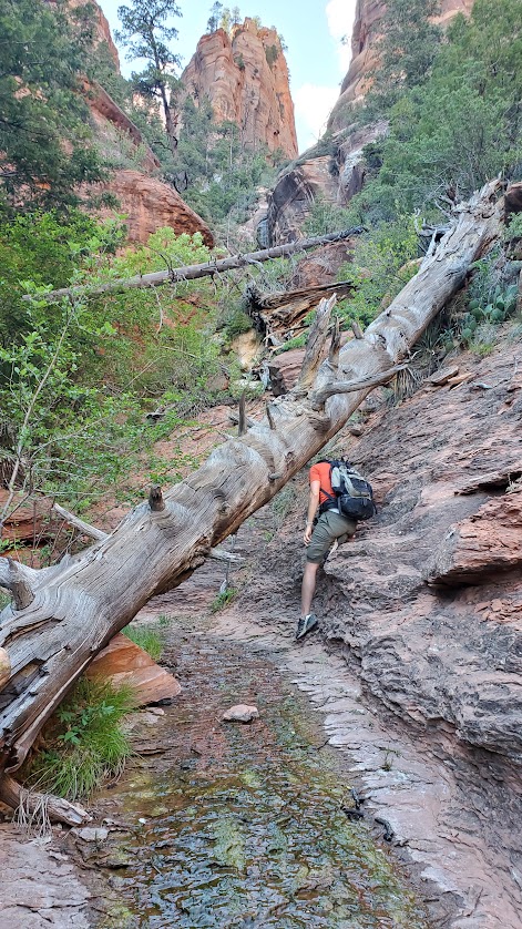
Once you get hiking up Middle Fork of Timber Creek the bushwacking starts almost immediately. If the river is dry it’s a bit more easy going, but either way you want to stay out of the river course as much as possible for the first mile. After this, the bushwacking gets really bad, and all but the most dedicated & awesome will turn around.
There are two small water falls which are both easily bypassed up steep slopes to the right.
Sweatbox beta: To Do
- Descent: each rappel/downclimb in order (height, anchor type), key obstacles
- Where it meets the Kolob Arch trail and the hike out
- Photos / GPS waypoints
The Saddle. The saddle is huge pile of sand, and is most easily climbed on the left/north side of the canyon until you get about 1/2 to 2/3’s the way up and you’ll see paths up out of the rocky watercoarse toward the big pine trees at the center of the saddle. Travel up the left/north side also allows for a short 150 yard slickrock traverse back downcanyon to an amazing lookout viewpoint.
From the saddle you’ll see amazing views of Icebox canyon and several unnamed canyons feeding into it. Ours is the canyon at the base of the immediate slope heading down to the south (this small subcanyon parallels, and flows into Icebox). You will want to descend staying RIGHT/WEST as much as possible to attain the western side of this canyon.
Follow the ledge into the great alcove instead of following the drainage to its bottom
As you drop steeply down out of the grand alcove at its southern-most end to a forrested shelf 20-40 feet above the canyon floor you should cross a old faint trail which you can follow southward along the the canyon. About 30 yards before it cliffs out, there is a wooded slope which allows access the the canyon floor.
Follow the canyon floor uphill as it gets steeper and steeper but allows a fairly easy (but steep) access to the top of the sadle by staying primarily on the left/east side of the canyon.
Once atop the saddle there is a short bushwack through a thick maple grove until a wash starts to develop on the right/west which allows for slightly easier decent down the canyon. The first rapel is a little over .25/quarter mile from the saddle, after downclimbing a large 10′ boulder near a pine tree. There should be webbing on this tree. A quick succession of six rapels follows in the next .25/quarter mile as the canyon steeply descends.
All of these rapels are often wet, slipery, narrow and full of assorted chalkstone hazards so take care not to get ropes stuck. Only one of them has a vertical drop larger than 30 feet, but all of them have very steep tricky sections above or below the actual drop which even if easily downclimbable, most will simply choose to stay on rope and rapel for safty sake. Because the largest rapel necesitates a rop of at least 160′ (and preferably 220′), I am counting the entire ‘on-rope’ drop in the height.
| # | Anchor | Height | Notes |
|---|---|---|---|
| R1 | Tree webbing | 65 ft | Use tree 15′ up from rapel, which has 2 parts. A 25′ vertical overhang from chalkrocks and less vertical lower crack. |
| R2 | Chalkstone Rock/Logs | 45 ft | slickrock spillover to ~15ft vertical drop above 10′ long plung pool. (often a swimmer, but skilled cimbers can stem accross & help others to bypass) |
| R3 | Tree/log | 65 ft | Very slippery/narrow 2 part rapel. Stay on rope for second ~15′ bottom which looks downclimbable but is VERY slippery. Pool at bottom ussually easy to bypass. |
| R4 | 5″ Tree | 110 ft | Two part slickrock spillover direcly above R5, which can be descended without rope, but if wet/slippery you may want to rapel to be safe. |
| R5 | Double ~3″ Tree | 80-105 ft | Largest Rapel from set of two small pine trees. Desend either straight down the watercoarse or hang right for a ledgy/chaucy stairstep with an easier lip. Landing is a steep 15′ slope which is easier if you have enough rope to descend to second landing. |
| R6 | ~3″ Tree or log | 45 ft | Rapel ~25′ to a large ledge then an additional 15′ to the canyon bottom near shallow pool. |
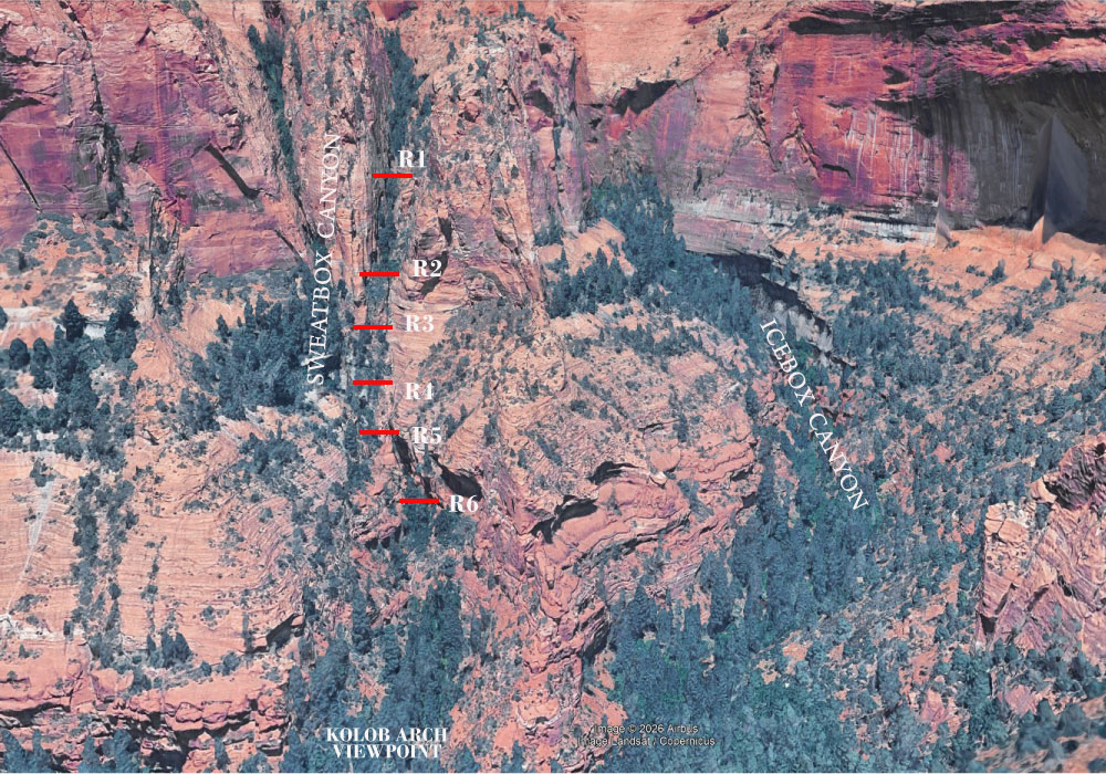
Note: If your rope isn’t long enough, there mayb be other options on Rapel #5. Before decending or rapeling R4, you can climb up the right side ridge and there may be some trees and shelves that you can drop into the sidecanyon which R5 descends, with a slightly smaller rope.
From the bottom of R6 follow the watercourse 0.2 miles to the Kolob Arch trail/viewpoint. Exit is 0.6 miles from viewpoint to Lee Pass/Kolob Arch trail confluence and then 6.5 miles to Lee Point trailhead or less if you entered through Lee Pass cutoff.
Part 3: Glovebox, South Fork of Timber Creek
Glovebox is the south fork of Timber Creek. It’s an out-and-back that ends at a beautiful alcove.
There’s really not much to this trail description. It’s best accessed from the Lee’s Pass cutoff, because the up & down climbing nature of the last mile of Lee Pass sucks a duck and whoever made the trail should be flogged.
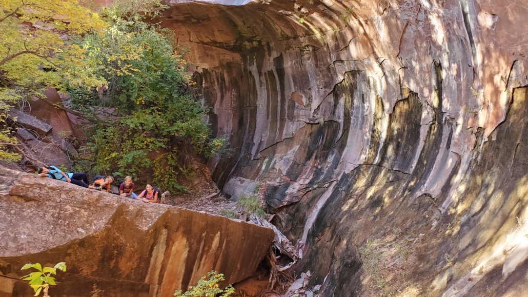
The Lee Pass cutoff dumps you onto the Lee Pass trail about 0.5 miles from the confluence of South Fork of Timber Creek and the main fork. Just bushwack your way up the (ussually dry) creek bed until you hit the alcove and spring.
The alcove is quite pretty, and the bushwack is not bad.
[Glovebox beta: To Do]
- Quick facts: distance, time, difficulty, any scrambling, water
- Route up the south fork and what’s at the alcove
- Photos / GPS waypoints
A Note on the Bushwhack (and Leaving No Trace)
All three of these canyons are bushwhacks right now: Icebox’s Timber Creek approach and ridge, and the full length of Sweatbox and Glovebox. They could honestly use a little more traffic so that a single, less miserable use trail settles in. If you go, please help that happen the right way:
- Keep to one line. Follow the existing use trail or the canyon bottom and wash instead of fanning out and making new braids.
- Walk on durable surfaces like rock, gravel, and the wash bed whenever you can, and stay off the cryptobiotic soil.
- Keep groups small, especially in the narrow sections and on the Slickrock entry.
- Pack out everything, including old webbing you replace at anchors.
- Get your permit, and respect Kolob Arch closures and the “don’t approach” signs at the viewpoint.
Sources (Icebox)
- Tom Jones, Canyoneering USA: Icebox Canyon, plus the Kolob Arch hike page for the waterfall height
- BluuGnome: Icebox Canyon North Entry, with detailed waypoints and a rappel-by-rappel log
- Road Trip Ryan: Icebox Canyon
- Ropewiki: Icebox Canyon (Zion National Park)
Beta changes, and anchors especially. Check recent condition reports before you go. These are not official trails and rangers are NOT going to be up to date on conditions. Probably only a handful of people have ever done Middle Fork, and rescue from injury in some parts of these canyons could be incredibly difficult. DO NOT GO ALONE. Be sure someone knows where you are Be VERY aware of snow bridges… falling through can be DEADLY.