
• Link to Facebook
  • Link to Instagram
  • Link to Youtube
  • Home
  • Tours
  • About
  • Contact
UtahGeology
  • Guided Tours
  • Hiking Guides
    • Geologic Hiking Guides
  • Geoarchaeology
    • Archaeology Explorer
    • Were the Ice Ages Caused by True Polar Wandering?
  • Geologic History
    • Utah Geologic History
    • Geologic History Overview
    • Geologic History of Utah & the Colorado Plateau
  • Road Guides
    • Utah Geologic Road Guides
    • Road Guides Overview
  • Geologic Formations
    • Geologic Formations
    • Geologic Formations Overview
  • Stratigraphic Columns
    • Utah Stratigraphic Columns
    • Stratigraphic Columns Overview
    • Layer Thickness Map
  • More
    • About
    • Contact
    • Geo Imagery
    • Earthquake Viewer
    • Interactive Map Gallery
    • Whats New?
    • Image & Copyright Policy
    • Web Links
  • Click to open the search input field Click to open the search input field Search
  • Menu Menu
You are here: Home1 / redwall limestone

Tag Archive for: redwall limestone

Grand Canyon’s Redwall Limestone (Geology of The Grand Staircase)
March 7, 2026/in Geologic Formation Pages/by Lance Weaver
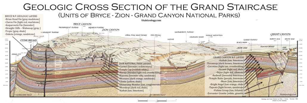
Geologic Cross section of the layers of The Grand Staircase from Bryce through Zion to the Grand Canyon National Parks. Note the Navajo forms the walls of Zion Canyon.

Explore unit thickness in All-in-One App

Grand Staircase Strat Column (Link).

Exposure:

Prominent throughout the Grand Canyon (e.g., South Kaibab Trail); also visible in the Virgin River Gorge, Pavant Range, and San Rafael Swell.

Age:  Mississippian, 359-330 million years ago.

Depositional Environment: High-energy shallow marine shelf. Specifically, a carbonate platform featuring oolitic shoals, crinoid thickets, and lime-mud flats distal from continental sediment sources.

Paleogeography: Located on the western passive margin of Laurentia. The region sat at approximately 10°–20° North latitude, effectively making it a tropical coastal shelf.

Tectonics: Characterized by a stable cratonic platform with slow subsidence. Distal to the developing Antler Orogeny (Cordilleran arc) to the west; largely undeformed until the Laramide.

Climate: Tropical to subtropical; warm, clear, and well-oxygenated waters promoted massive biological carbonate production and the growth of widespread coral and bryozoan colonies.

Features: Notable for its massive verticality and Thunder Springs Member, which contains distinctive alternating bands of gray limestone and dark, weather-resistant chert lenses.

Fossils: Extremely fossiliferous; dominated by crinoid columnals, spiriferid brachiopods, rugose (horn) corals, and bryozoans. Rare nautiloid “death beds” and fish teeth are also found

View looking north from Tuweap area near Toroweap Point.

Description:

The Redwall Limestone is perhaps the most iconic architectural element of the Grand Canyon, forming a singular, vertical precipice that averages 500 to 800 feet in height. Despite its name and vibrant exterior, the formation is actually a light-gray, high-purity carbonate (~99% limestone and dolomite); its famous “red wall” is merely a superficial iron-oxide stain leached from the overlying Supai Group and Hermit Formation. Depositionally, the Redwall represents a massive marine transgression during the Mississippian Period (approx. 340 million years ago), when a warm, clear, epicontinental sea flooded the stable North American craton. This shallow-water shelf environment was largely free of terrigeneous (land-derived) sediment, allowing for the accumulation of thick successions of bioclastic lime muds and sands.

From a broader tectonic perspective, the Redwall Limestone was deposited along a passive margin on the western edge of the Laurentian continent, situated within the subtropics. This was a time of relative tectonic quiescence for the Southwest, preceding the dramatic crustal shortening of the later Paleozoic. To the west, the Cordilleran Miogeocline was beginning to transition into a more active setting as the Antler Orogeny initiated in present-day Nevada, yet the Colorado Plateau remained a stable, subsiding platform. The unit is divided into four distinct members—the Whitmore Wash, Thunder Springs, Mooney Falls, and Horseshoe Mesa—which record two major cycles of rising and falling sea levels (transgressions and regressions), resulting in a complex internal stratigraphy of massive limestone ledges and chert-rich layers.

A modern analog for the Redwall’s depositional environment can be found in the Great Bahama Bank. Like the ancient Mississippian seaway, the Bahamas feature a broad, shallow carbonate platform where biological activity—rather than river-fed silt—drives sedimentation. In this clear, sunlit water, a diverse community of benthos thrived, including crinoids, brachiopods, and corals. Eventually, as the sea retreated at the end of the Mississippian, the exposed limestone surface underwent intense subaerial weathering. This led to a widespread paleokarst landscape characterized by sinkholes and caverns, many of which were later filled with the red mudstones of the Surprise Canyon Formation and Supai Group, creating a significant disconformity (a gap in the geologic record).

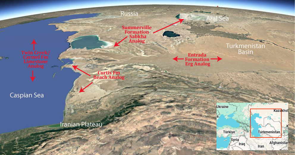
Modern Analog to Utah’s Middle Jurassic
Trade this out with the Indus Delta!

.

Paleogeography or Depiction of Utah during Middle Jurassic

What is the Grand Staircase?

The Grand Staircase is a unique and extensive exposure of Earth’s history, showcasing over 200 million years of sedimentary rock layers. Geologists often liken these layers to a “book,” allowing for a detailed study of the Earth’s past, including changes in climate and environment.

The major sedimentary rock units exposed in the Grand Canyon range in age from 200 million to 600 million years and were deposited in warm shallow seas and near-shore environments. The nearly 40 identified rock layers of Grand Canyon form one of the most studied geologic columns in the world.

[flickr_tags user_id=”95435349@N04″ randomize=”true” margins=”4″ pagination=”numbers” tags=”navajo” max_num_photos=”9″]

[flickr_tags user_id=”95435349@N04″ tags=”chinle, navajo”]

https://utahgeology.com/wp-content/uploads/2025/07/utah-geology-site-logo-420px-new.png 0 0 Lance Weaver https://utahgeology.com/wp-content/uploads/2025/07/utah-geology-site-logo-420px-new.png Lance Weaver2026-03-07 02:06:152026-03-10 23:39:17Grand Canyon’s Redwall Limestone (Geology of The Grand Staircase)

Welcome

About me
Lance Weaver. about me.


Book a Tour

Popular
  • Tracks, Traces & Other Fossils of The Grand Canyon &...January 7, 2025 -
  • When Was The Colorado River Formed?February 21, 2025 -
  • Were the Ice Ages Caused by True Polar Wandering?September 21, 2020 -
  • Navajo SandstoneApril 16, 2015 -
  • The Vishnu SchistNovember 14, 2018 -
  • Take Away Lessons from my Experience with the Jerold Williams...August 10, 2015 -
  • The Geology of Zion National ParkNovember 14, 2018 -
  • Utah’s Three Types of VolcanoesMay 26, 2015 -
  • Grand Canyon’s Bright Angel Shale (Geology of The...March 10, 2026 -
Recent
  • When Was The Colorado River Formed?February 21, 2025 -
  • Tracks, Traces & Other Fossils of The Grand Canyon &...January 7, 2025 -
  • Grand Canyon’s Bright Angel Shale (Geology of The...March 10, 2026 -
  • Grand Canyon’s Tapeats Sandstone (Geology of The...March 10, 2026 -
  • Grand Canyon’s Muav Limestone (Geology of The Grand...March 7, 2026 -
  • Grand Canyon’s Redwall Limestone (Geology of The...March 7, 2026 -
  • The Cretaceous (Cretassic) Period: A Geologic Proposition...March 2, 2026 -
  • A Geologic Overview of Lake Powell, UtahFebruary 15, 2026 -
  • Pine Park and the Ancient Supervolcanoes of Southwestern...February 15, 2026 -
  • The Weaver Precessional Polar Oscillation Cycle & Core-Mantle...January 3, 2026 -
Comments
  • Lance WeaverIf you want to visit some of these formations check out...May 11, 2026 - by Lance Weaver
  • Mads Erik HusdalThe amount of work you have put in this is mind boggling!...February 23, 2026 - by Mads Erik Husdal
  • Gabor Szuecs dr.Because the pole was not where it is today. Around the year...February 8, 2026 - by Gabor Szuecs dr.
  • Alan FullerUpdate to previous post. After a more thorough read I have...December 30, 2025 - by Alan Fuller
  • Alan FullerFantastic piece of work I think you have basically described...December 26, 2025 - by Alan Fuller
  • Lance WeaverNo. Despite what some say, there are no specific 'angles'...November 21, 2025 - by Lance Weaver
  • Mark RademakerLance, i have read that the cross beds of Checkerboard Mesa...November 9, 2025 - by Mark Rademaker
  • Mark RademakerLance, have you dug into Dr. John Whitmore's material in...November 9, 2025 - by Mark Rademaker

Follow us on Facebook

UtahGeology
Logo image
Go to facebook page
Join the Facebook community!

Tag Cloud

Frontpage Article Geoarchaeology Geologic Formation Pages Geologic Hiking Guides Images News Uncategorized

Important Pages

Privacy Policy,    About utahgeology.com,    Contact Us,   
Image & Copyright Policy

Relevant Links

  • Utah Geological Survey
  • U.S. Geological Survey
  • Arizona Geology Blog
  • Durango Bill
  • Zion Experiences

Contact Me

Utahgeology is a 501c nonprofit. If you would like to contact me, drop me a line from the contact page. Or if you have questions about geology, call me during normal work hours at the Utah Geological Survey.
© Copyright - UtahGeology - Enfold Theme by Kriesi
  • Link to Facebook
  • Link to Instagram
  • Link to Youtube
Scroll to top Scroll to top Scroll to top
