When Was The Colorado River Formed?
Raise of the Colorado Plateau (33-15 MYA), and Formation of the Colorado River & Grand Canyon
Introduction
For over two decades, the geologic community has remained locked in a debate regarding the “Old” versus “Young” Colorado River, often missing the forest for the trees. By hyper-focusing on localized datasets—such as the geochemical signatures of the Grand Wash Trough, the Peach Springs Tuff, or the elusive zircon dating of downstream alluvium—researchers frequently ignore the most significant evidence staring them in the face: the relationship between drainage reversal, ponding events, canyon incision and the regional tectonic upwarps. To understand the Colorado River’s evolution, we must prioritize two diagnostic features: the canyons that cut through massive structural folds and the lacustrine (lake) “fill-to-spill” deposits that inevitably accompany major drainage reversals.
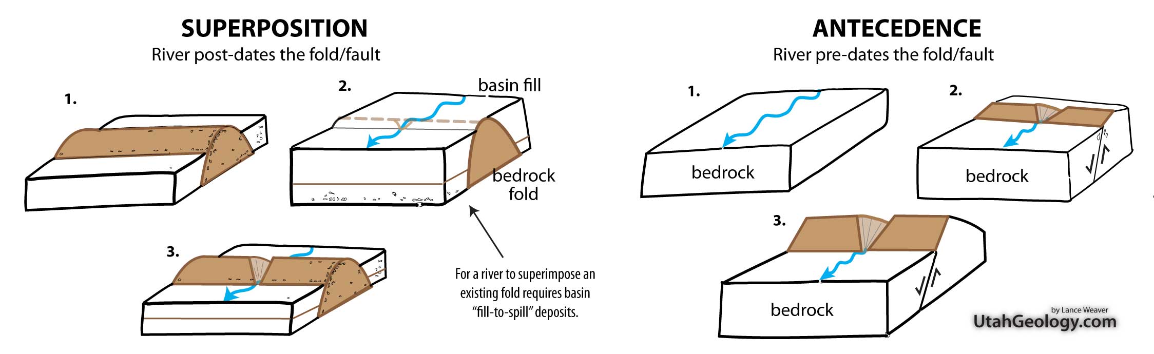
Addressing the former first, its important to remember that in all locations which completely lack ANY evidence of large basin fill deposits suggesting a fill-to-spill scenario of fold overtopping– the fold had to pre-date or “antecede” the upwarps of the Colorado Plateau in order to maintain eroding a coarse & canyon through these massive folds as they formed. Let me repeat that. A river HAD TO PREDATE most the major Laramide folds which the modern rivers currently cut through. There is simply no way around it. (Pun intended!). The Colorado River cuts through the Kaibab, Monument, Circle Cliffs, Uinta/Split Mountain, and Uncompahgre uplifts, and its tributaries cut through the Cockscomb, VRG, San Rafael swell and other upwards, with ZERO evidence of basin fill deposits behind the fold in most cases. This strongly suggesting these watercourses were established BEFORE the upwarps began to rise significantly in the Cretaceous & early Tertiary.
This fact alone helps us to ascertain that the river courses through most large folds on the Colorado Plateau are very old. Older than the very folds themselves.
However, it’s also fairly well established that the general drainage in Utah & the Colorado Plateau throughout the Cretaceous & earliest Tertiary was opposite of present, to the NORTH and EAST from the Nevada & Arizona highlands into the retreating Cretaceous seaway, which causes a bit of a puzzle. Much like the fill-to-spill character of a river crossing a superimposed fold, drainage reversal REQUIRES ponding of a drainage as the continental divide passes perpendicularly across the drainage.
The Great Reversal: A Case for the Oligocene Integration of the Colorado River
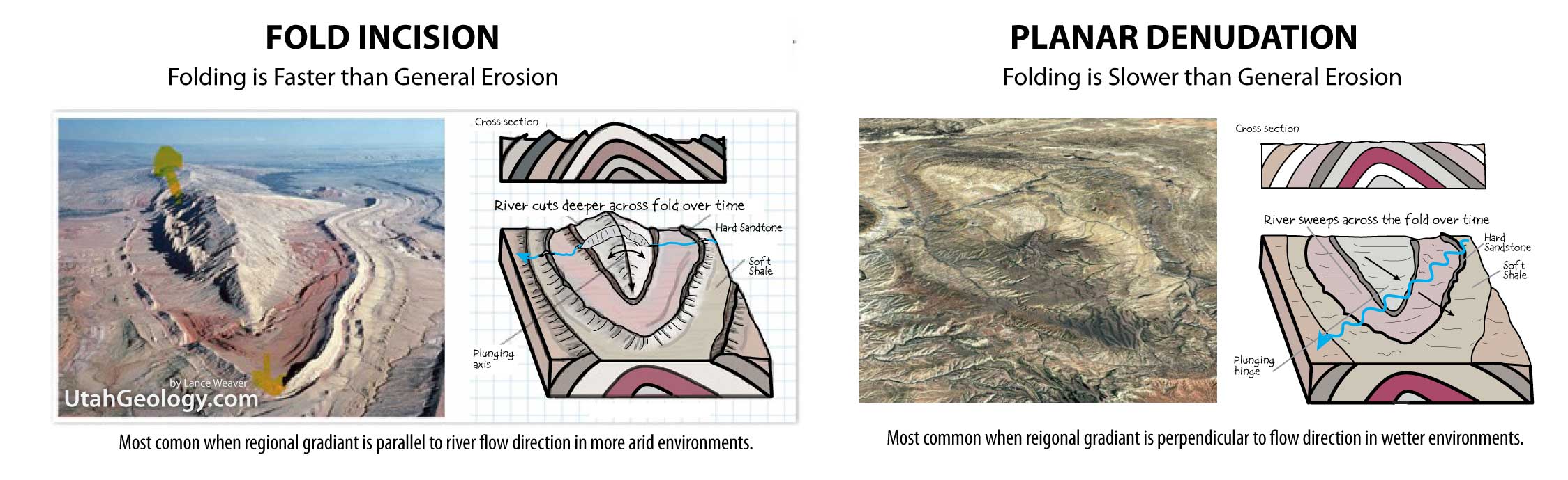
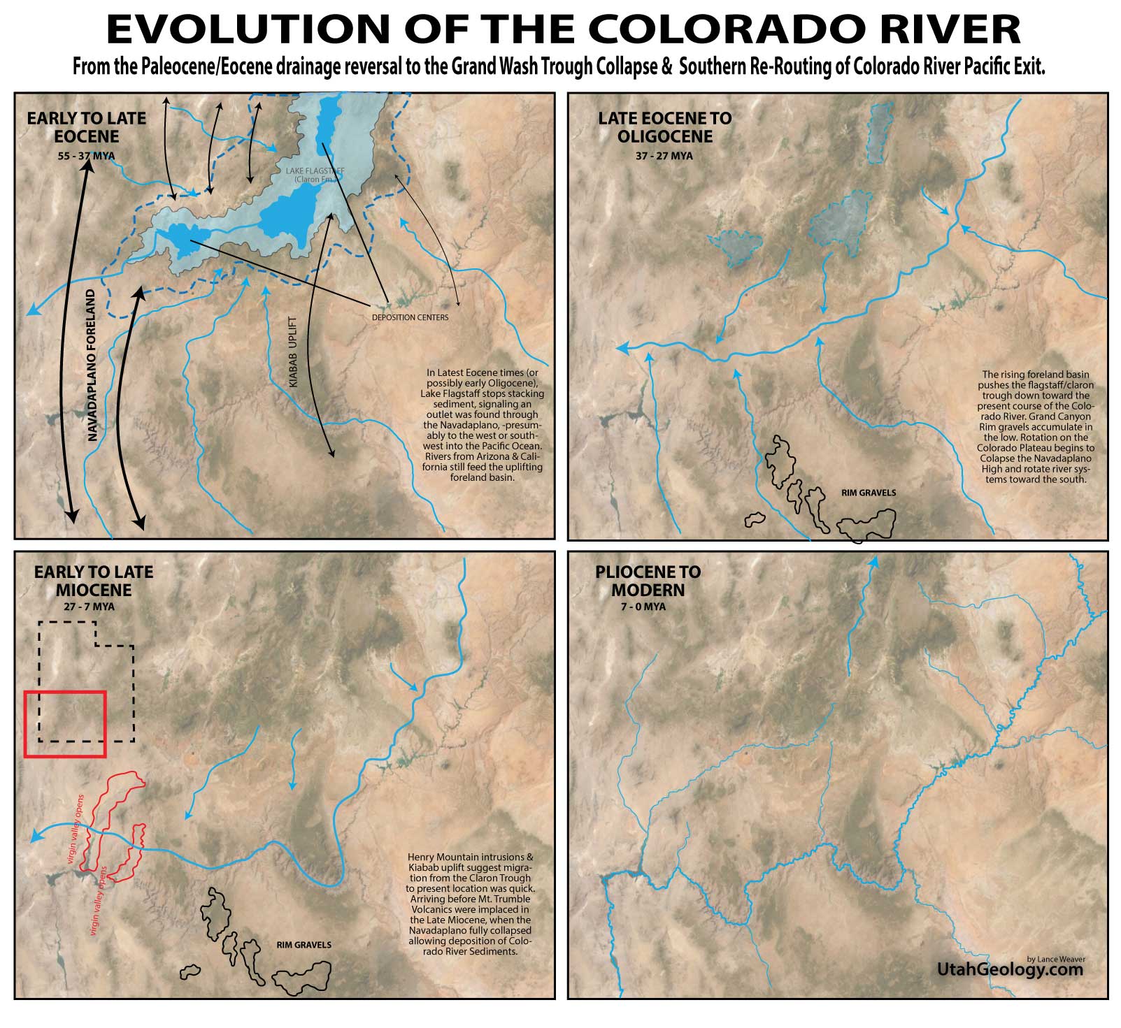
So the question is… where is the ponding evidence for the drainage reversal? Researchers have been looking for ‘reversal deposits’ for decades in regard to the debate on the Colorado River’s evolution. Yet to date, the paltry Bidahochi Formation on the Defiance Upwarp is the only proposed candidate for a Tertiary Lake deposit marking the ‘Great Reversal’. But frankly the obvious answer has been staring us in the face the whole time. The Great Paleocene & Eocene lakes of Utah & Wyoming are the evidence of the reversal & beginning of the Colorado River! It was during the Paleocene & Eocene that drainage reversed from Northeastward flow to Southwestward flow, and the proto-Colorado River established its outlet to the Pacific Ocean through a pass in the Mountains during that time. Much like present Ganges River draining the Tibetan plateau through the front range of the Himalayas. It follows then, that as the Nevadan/Arizonan Arc collapsed in the Mid to Late tertiary, the Colorado River had ALREADY established an outlet to the Pacific, allowing it to maintain courses through canyons of the “Navadaplano” and the gentle folds of the Colorado Plateau. Afterwards, the river was pushed ‘laterally east & southward’ from the centerline of the Eocene lakes to its present location causing ‘planar denudation’ (see figure) of many folds before it settled into its present location and began rapid canyon incision late in the Cenozoic.
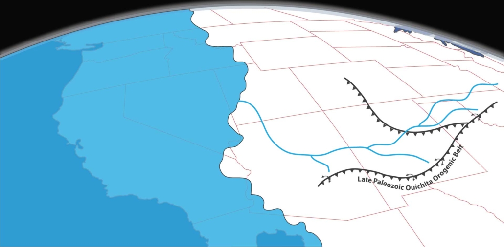
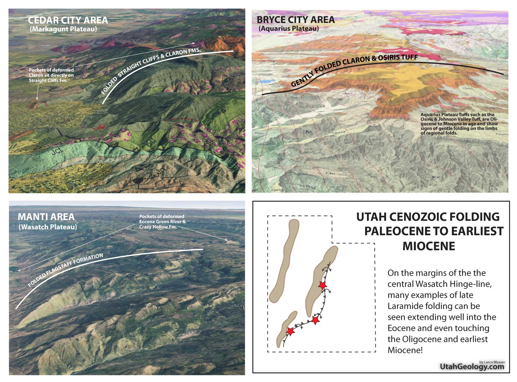
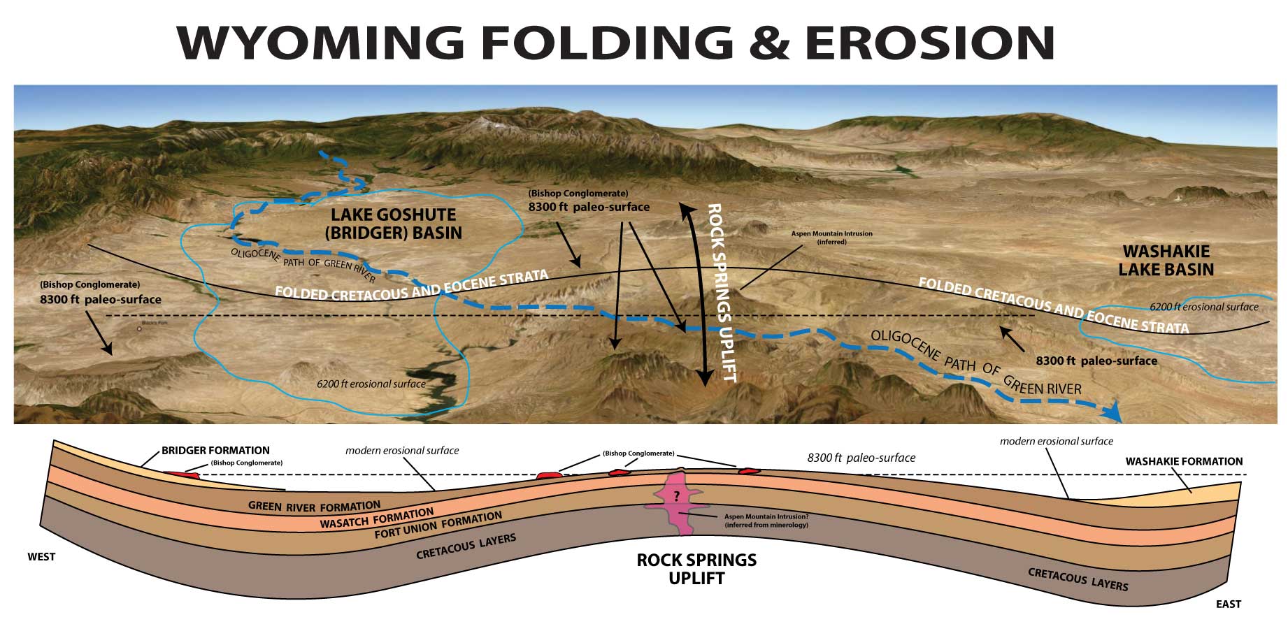
This lateral ‘pushing’ of the river from the west toward the east by eastward migrating Laramide orogenic forces can be clearly seen by the folding of Eocene and Oligocene (and even early Miocene) deposits in central Utah. The steeply folding early Cenozoic deposits on the Wasatch Plateau as well as folding under Thousand Lakes Mountain and Boulder Mountain clearly show that folding persisted at least as late as the Signal Peak volcanic rhyolites (26-25mya) which blanket Boulder Mountain. These eastward migrating fold belts would have pushed the proto-Colorado river from the location of its initial inception (in the center of the filled Eocene lake Uinta & Flagstaff) to it its current location between the dates of around 35mya and 21 mya as constrained by the period Oligocene lakes STOPPED retaining sediment (~35mya) to the time that the Signal Peak Volcanics and Henry Mountain laccoliths were emplaced.
Oligocene Folding and Volcanism
There is a widespread misconception, even among seasoned geologists, that the elevation differential of the west-facing slopes of plateaus like Markagunt Plateau, Pansagunt Plateau, Wasatch Plateau, and the Aquarius Plateaus have somehow been “uplifted” by the Normal Faults that bound their west sides. To the contrary, however, every one of these plateaus are actually remnants of pre-extensional folds. And as already discussed, because many of these folds deform Eocene, Oligocene & even early Miocene strata, they must post-date the 45-23 Ma deposition of that strata. This evidence necessitates that massive folding must POST-DATE 33 Ma and PRE-DATE the the onset of Basin and Range extension around 17–12 Ma. This “window” is a huge, poorly understood, and poorly taught fact in Western geology! This timeframe includes the late deposition of the Browns Park Formation, which was likely being deposited behind deformation of the Uinta Arch. As well as Miocene deposits associated with the Rio Grande rift and the Mesquite Basin north of the Grand Wash Trough– caused by rotation of the Colorado Plateau which I believe was responsible for the initial uplift of the Plateau and obliteration of evidence of the ancient outlet of the pre-extensional Colorado River.
This all fits together because these Colorado Plateau bounding folds are undoubtedly associated with the Plateau’s primary rise and the widespread explosive volcanism of the region. From the massive calderas bounding the Plateau to the intrusive laccoliths and dikes, everything points to a rise dating from 33 Ma to 15–12 Ma when the Basin and Range collapse began. The transition from the marine Cretaceous to the lacustrine Claron and Green River lakes is the biggest clue we have. Furthermore, the age of the massive erosional surface of the clastic apron of Bishop Conglomerate undoubtedly dates a major erosional surface on the Colorado Plateau and its folds. It is well-constrained by ash beds to 34–30 Ma and correlates to the Starr Flat Member of the Duchesne River Formation, marking a massive erosional pulse that followed the plateau’s first great heave.
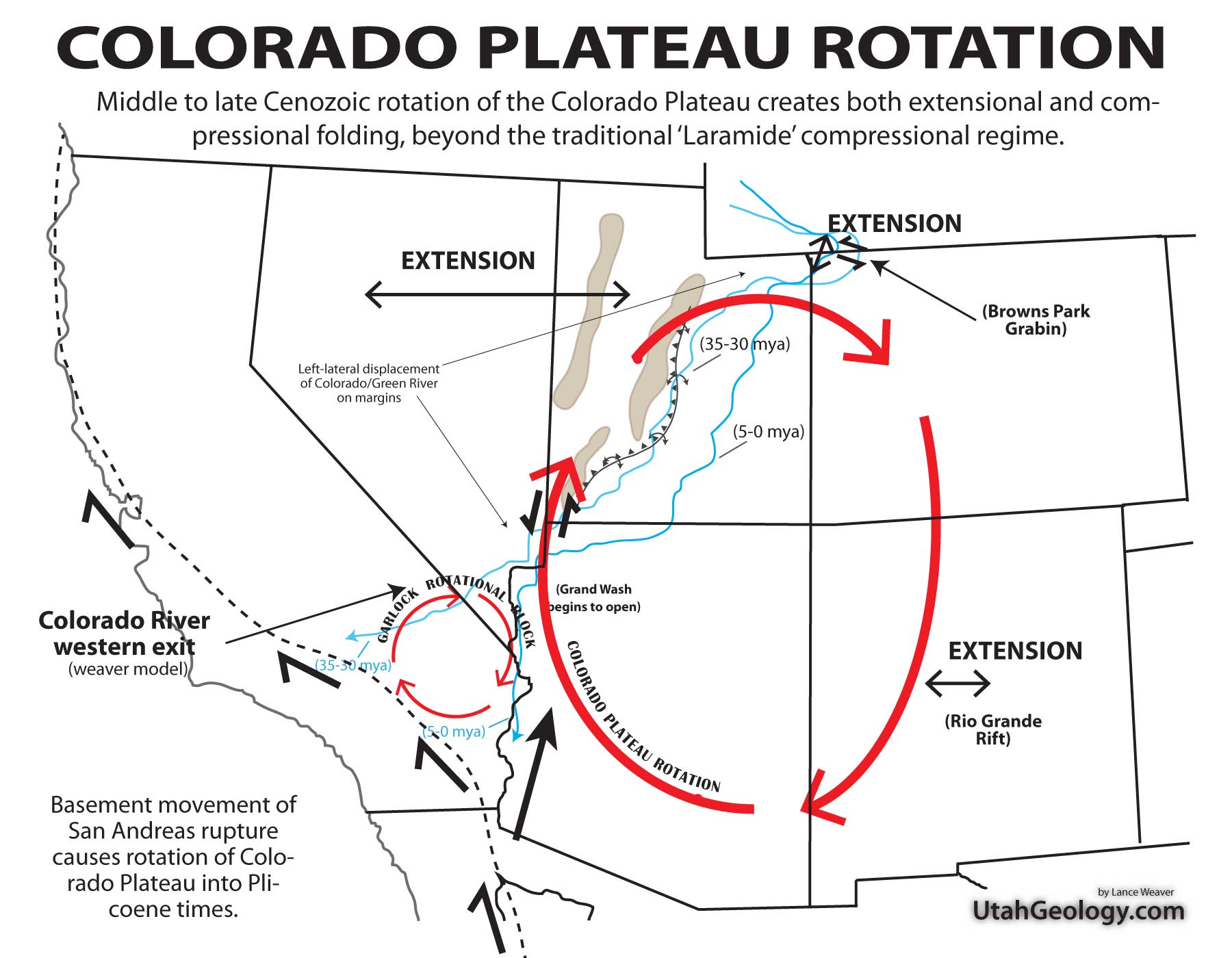
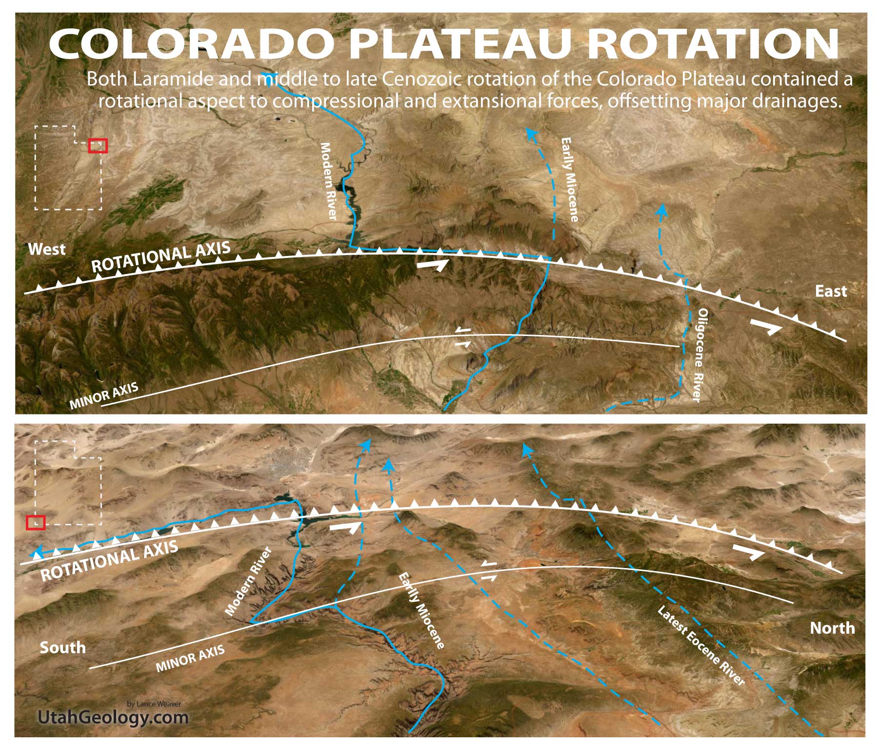
Clockwise Rotation of the Colorado Plateau
The rotation of the Colorado Plateau began as a byproduct of Laramide Orogeny crustal shortening, where the lithospheric block acted as a rigid “microplate” resisting the intense deformation surrounding it. While initial movement was subtle, the rotation accelerated significantly with the transition to a transform plate boundary and the development of the San Andreas Fault system. As the Pacific Plate began its northward migration, it exerted a dextral shear force on the basement blocks of the Mojave and Basin and Range provinces. These blocks essentially “tugged” at the southwestern periphery of the plateau. This mechanical coupling—facilitated by the Garlock Fault acting as a conjugate shear zone—transformed translational motion into a clockwise pivoting action. This rotation is uniquely characterized by contemporaneous extension, a phenomenon often overlooked by researchers who treat the plateau as entirely stable; in reality, the “dragging” of the periphery creates a tearing effect that opens extensional basins even as the core remains intact.
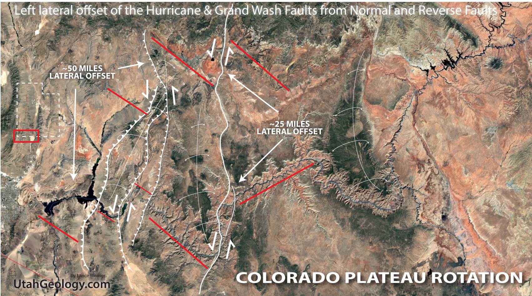
This rotational torque is deeply tied to the fate of the subducted Farallon Plate. As the Farallon slab foundered and “swallowed” into the mantle, the resulting slab rollback and delamination created a suction effect that allowed the lithosphere to move more freely, potentially providing the “lubrication” necessary for the plateau to rotate over the mantle. This motion has profoundly altered the structural landscape of Southern Nevada and Northern Arizona, most notably along the Grand Wash Fault. As the plateau pivots, it exerts a “shoving” force against the Basin and Range, intensifying faulting and causing the southward “migration” of drainage systems. The Colorado River, in particular, has been caught in this tectonic mill; the plateau’s rotation has effectively “dragged” the river’s lower course southward, forcing it to incise through rapidly rising basement blocks and contributing to the complex, multi-stage evolution of the Grand Canyon’s exit point at the Grand Wash Cliffs. On the opposite sides of the Colorado Plateau, this same rotation can be seen in lateral offsets of both the Rio Grande Rift and the Browns Park Graben as well.
.
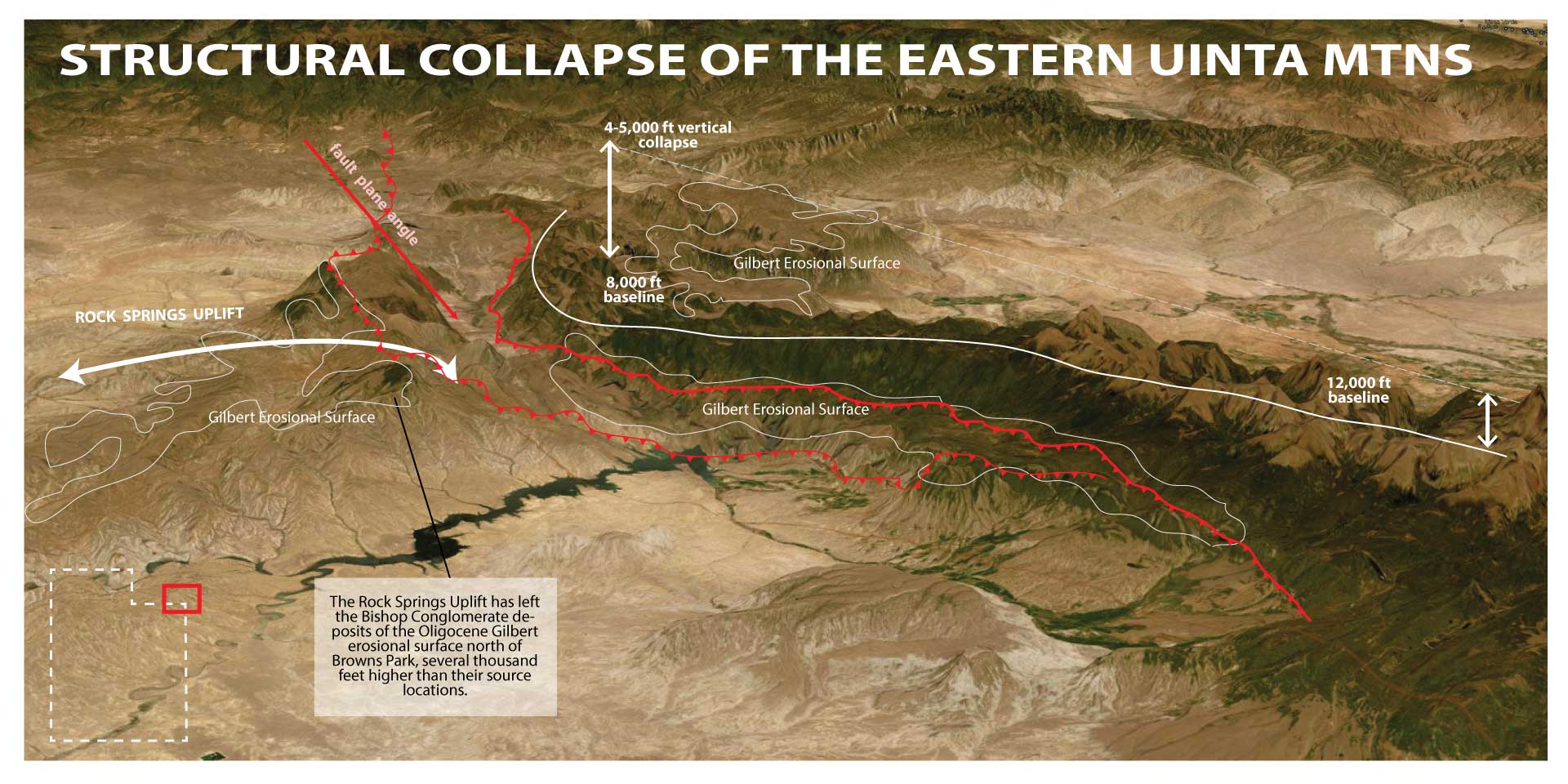
The Gilbert Erosional Surface
The Gilbert erosional surface and the Bishop Conglomerate that is draped over it, provide an unmistakable structural “timestamp” for the evolution of the Colorado River system. This vast, high-level pediment surface suggests that by the Oligocene (roughly 34–30 Ma), the intense tectonic activity of the Laramide Orogeny had transitioned into a period of relative topographic stability. During this window, the valley’s below the Uintah’s (and other Laramide mountains) were worn down into a broad peneplain—a nearly level, low-relief landscape where rivers flowed across a flat expanse of eroded older rocks, much like the plains of modern-day Wyoming. The fact that the Bishop Conglomerate, a coarse, high-energy gravel deposit, sits undisturbed atop this surface proves that the deep incision of the Green and Colorado rivers had not yet begun in that region. Similar ‘rim gravels’ south of the Grand Canyon suggest a similiar situation at the south end of the Colorado Plateau. At that moment, the “saw” had not yet touched the “log”; the drainage was established on a flat, elevated sheet of sediment, poised to begin its downward cut only after the subsequent collapse of the Navadaplano Mountain belt or base-level shift of the Miocene.
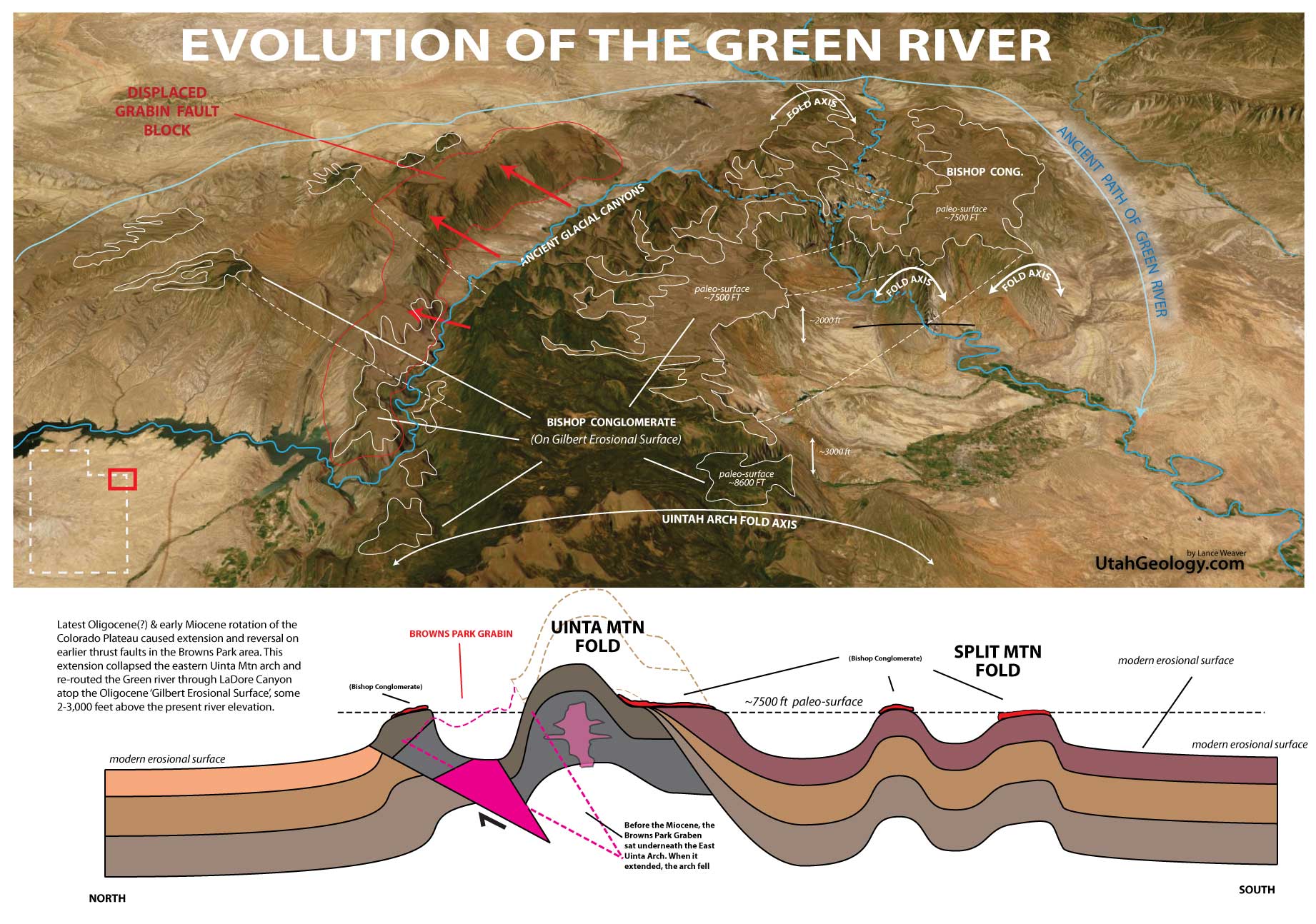
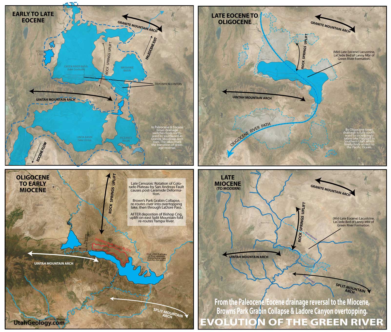
Integration of the Green River into the Colorado River
My argument in this article is that the Colorado River found its present outlet to the Pacific ocean in the latest Eocene or Oligocene as the Eocene lake systems of Utah, Colorado & Wyoming filled with sediment and allowed a ‘spillover’ of drainages through a low southwestern pass. I also argue that the 5-7 million year evidence for Colorado incision is misinterpreted. This being the point that collapse of the Navadaplano allowed deposition of Colorado River sediments and rapid down-cutting into the Colorado Plateau. NOT THE AGE OF THE RIVER! In a similar fashion I argue that the Green River found an early integration into the Colorado River during the same late Eocene & Oligocene fill-to-spill of the lake systems. And that the Browns Park Formation marks a period of Colorado Plateau rotation and graben collapse and incision, NOT the initial integration of the Green & Yampa rivers into the Colorado.
The Browns Park Formation and its associated graben do however provide the critical constraint on exactly when the Green River found its present course and began ‘sawing’ through the Uinta Arch. As the northeast limb of the Uinta Mountains were pulled apart by Miocene extension, the Browns Park graben began to drop, creating a structural trough that filled with volcanic ash and fluvial sediments. The crucial detail lies in the fact that the Green River currently flows across this graben and then dives directly into the heart of the Uinta uplift at Lodore Canyon. This relationship suggests that the river was “captured” or established within the soft fill of the Browns Park graben during the Miocene. Once the river overtopped its basin (one of the Colorado Plateau’s few “fill-to-spill” events), it was superimposed onto the harder, underlying Precambrian rocks of the Uintas. The timing of the Browns Park deposition (roughly 25 to 10 Ma) effectively pinpoints the transition from the flat Oligocene peneplain to the aggressive, canyon-cutting drainage system we see today.
Integrate these two papers. Link in the image descriptions:
‘Cenozoic collapse of the eastern Uinta Mountains and drainage evolution of the Uinta Mountains region’ https://doi.org/10.1130/GES01523.1
‘Assessment of In-Place Oil Shale Resources of the Eocene Green River Formation’ https://pubs.usgs.gov/dds/dds-069/dds-069-dd/REPORTS/69_DD_CH_1.pdf
.
Grand Canyon ‘Rim Gravels‘ as a Signal of Incision
The Oligocene “Rim Gravels” of Peach Springs and the Hualapai Plateau are great evidence for when the foreland basin of the raising central Utah thrust belt finally pushed the structural low to the present location of the Colorado River . Why don’t they exist until the Oligocene? Because from the Cretaceous to the Paleocene, rivers flowed unimpeded Northward into the Cretaceous seaway and later into the great Eocene lake systems and later into the rapidly approaching Colorado River system. In the Paleocene through Eocene the Claron & Green River basins became closed and waters and sediments were trapped in the closed lakes of.., these lakes began to rapidly rise, and it was the Oligocene when sediment filled the basin to the point of overflow finding an exit through a low pass in the Navadaplano mountains. After overflow, the river began to rapidly migrate toward the area of the Grand Canyon region, which acted as the structural low or hinge-point likely in the late Oligocene. That is why gravels started accumulating there and why it became the stopping point of the southward migrating river system. [rewrite]
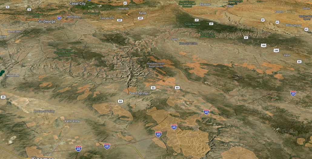
The Oligocene ‘Rim Gravels’ of Peach Springs and the Hualapai Plateau are another GREAT evidence of my theory. Why dont they exist UNTIL the Oligocene? Because from the Cretaceous to Oligocene rivers flowed unimpeded on high gradiants into the Utah oceans and lakes, but in the end Eocene these lakes began to rapidly raise, and it was the Oligocene when their rise reached the Grand Canyon region which was the hingepoint. Thats why it started accumulating gravels and why it became the stopping point of the southward migrating river!
.
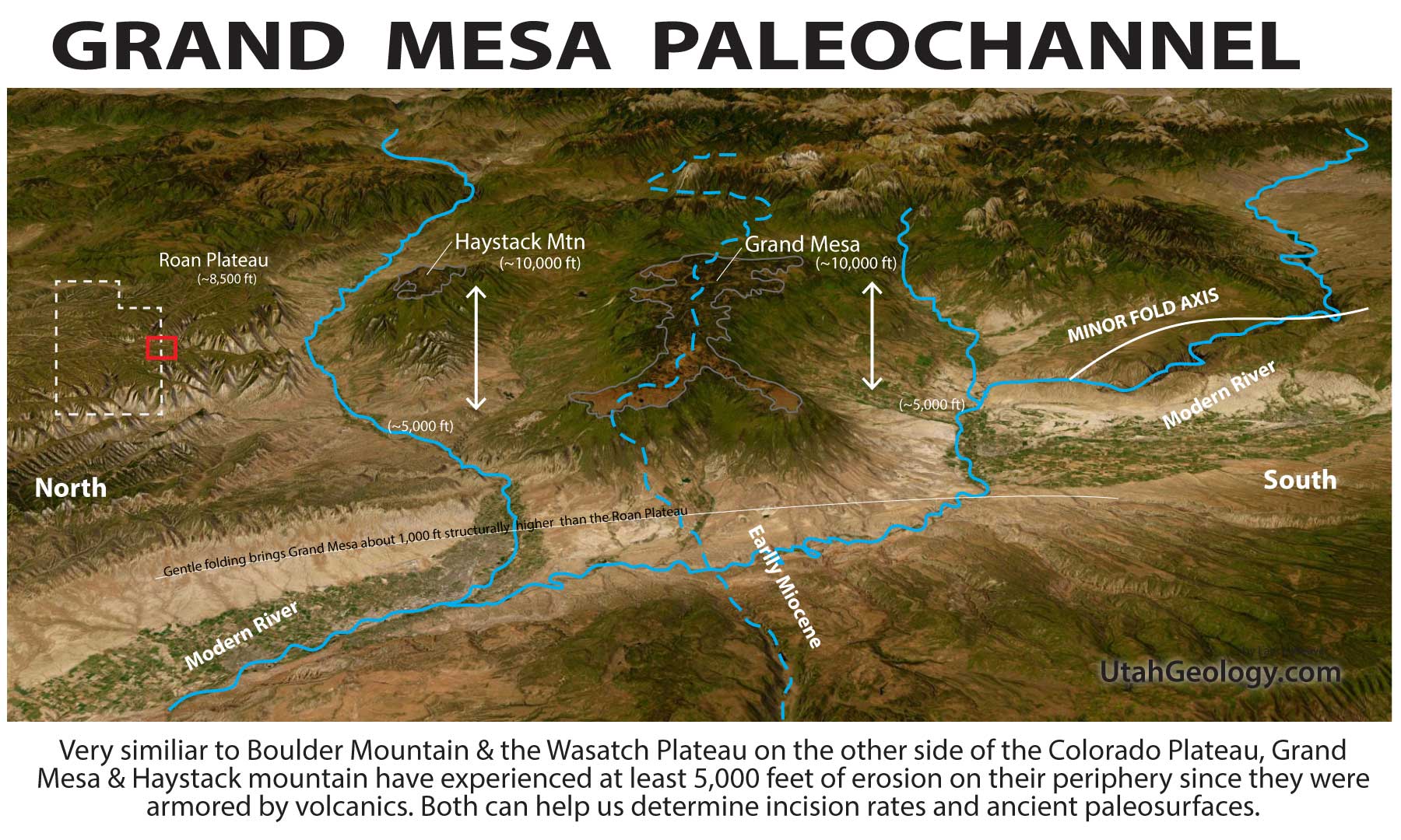
Grand Mesa as a Proxy for Rapid Incision
Grand Mesa in Westernmost Colorado is another great indicator for the geologic period when rapid incision on the Colorado River and Plateau began. It and its neighbor, Haystack Mountain, represent one of the most striking examples of “inverted topography” in the American West. Approximately 10 million years ago (Late Miocene), basaltic lavas erupted from vents to the east and flowed into a broad, low-relief paleovalley. This ancestral valley floor was carved into the Eocene-aged Green River and Wasatch Formations. At the time of the eruption, the landscape was remarkably stable; the unconformity between the Eocene sediments and the Miocene basalts suggests that very little of the original rock section—likely less than a few hundred feet—had been stripped away prior to the volcanic activity. These hard basaltic flows essentially “armored” the valley floor, preserving a snapshot of the regional elevation before the onset of the Great Denudation.
Since the emplacement of these basalts 10 million years ago, the regional drainage systems have undergone a period of rapid and aggressive incision. Today, the Colorado River to the north and the Gunnison River to the south have carved deep canyons, leaving the basalt-capped Grand Mesa standing approximately 5,000 to 6,000 feet above the modern valley floors. This implies an average incision rate of roughly 150 to 180 meters per million years. This dramatic downcutting provides critical evidence for the relative youth of the modern Colorado River system; it suggests that the massive erosional power required to carve both the Grand Mesa region and the Grand Canyon downstream was likely triggered by the river’s integration with the Gulf of California around 6 million years ago, leading to a wave of headward erosion that rapidly dismantled the surrounding Eocene landscape while the armored mesa remained as a high-altitude sentinel.
Deposits of the Grand Wash Trough & Mesquite Valley
Finally, we must address the Hualapai Limestone, which fills the easternmost and highest basin of the Grand Wash Trough as the uppermost member of the Muddy Creek Formation. Some researchers, like Pearce (2010), suggest that because these layers lack “Colorado River signatures,” the river couldn’t have been there any earlier than detrital zircons might suggest. I think many greatly misinterpret detrital evidence. The location of the Oligocene river gravels and the Henry Mountains laccoliths upstream suggest the Colorado was pushed into a trough near its present location quite quickly after the end of drainage reversal manifested by the Eocene lakes. But ANY DEPSITS in the Grand Wash trough or Misquite basin do not necessarily tell us when the Colorado River started flowing through the region. They instead only tell us when those basins collapsed to a point where they began receiving depositional sediments. I suggest that the Colorado flowed through its upper gorge to a region south of the present Grand Wash Trough (transported south by rotational forces), likely without leaving much evidence until 5 Ma, when it was temporarily blocked from its west exit and redirected south by a pulse of collapse/shear forces. The layers in that trough are much like the flood deposits of Grand Junction to the north; most of the sediment comes from adjoining Cretaceous hills, but the river backed up occasionally during huge outflow floods from the Rockies. Pearce even mentions that the water chemistry is similar to spring-fed Havasu Creek (high in carbonate). I suggest this is not evidence of a local spring, but rather evidence of an ice-dam break, which caused a short-lived backup, allowing the limestone to form from the carbonate-rich waters of the high plateau.
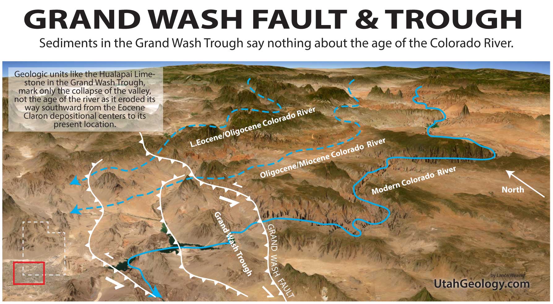
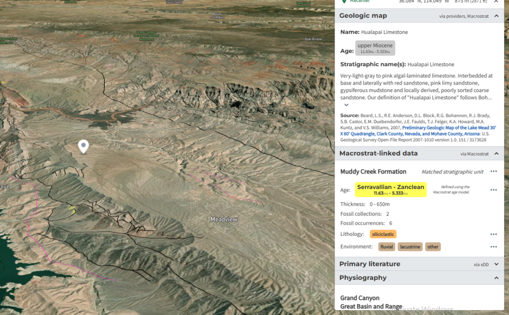
Also NOTE how the Hualapai Limestone fills the easternmost and highest basin of the Grand Wash Trough. It is the uppermost member of the Muddy Creek Formation.
Be sure to answer the Pearce 2010 paper that suggests that the Grand Wash Trough’s Hualapai Limestone (Miocene) and its layers beneath did NOT have Colorado River signatures. My argument is that the Colorado flowed through without leaving much evidence until 5mya when it was BLOCKED from its west exit and was redirected south. The layers in that trough were MUCH like the flood deposits of Grand Junction to the north, most the sediment in those layers come from the adjoining Cretaceous hills, but the river does back up occasionally during huge outflow floods from the Rockies. IN FACT she mentions that the water chemistry is like spring fed Havasu creek (high in carbonate), I suggest this is evidence of an ice dam break, which caused a short lived backup and limestone formation.
(See. Pearce, 2010) https://digitalrepository.unm.edu/cgi/viewcontent.cgi?article=1047&context=eps_etds
Write a bit on how you shouldn’t be looking in the grand wash trough for early colorado river sediments….
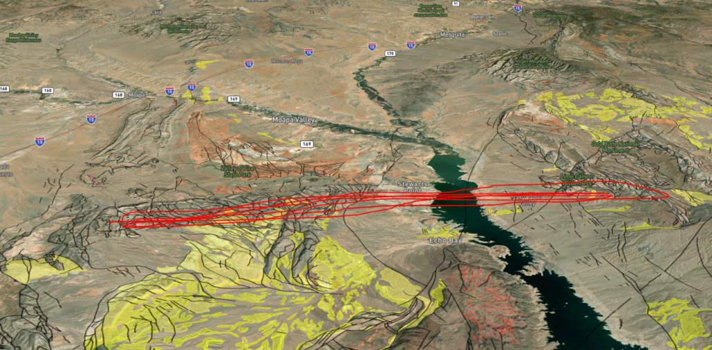
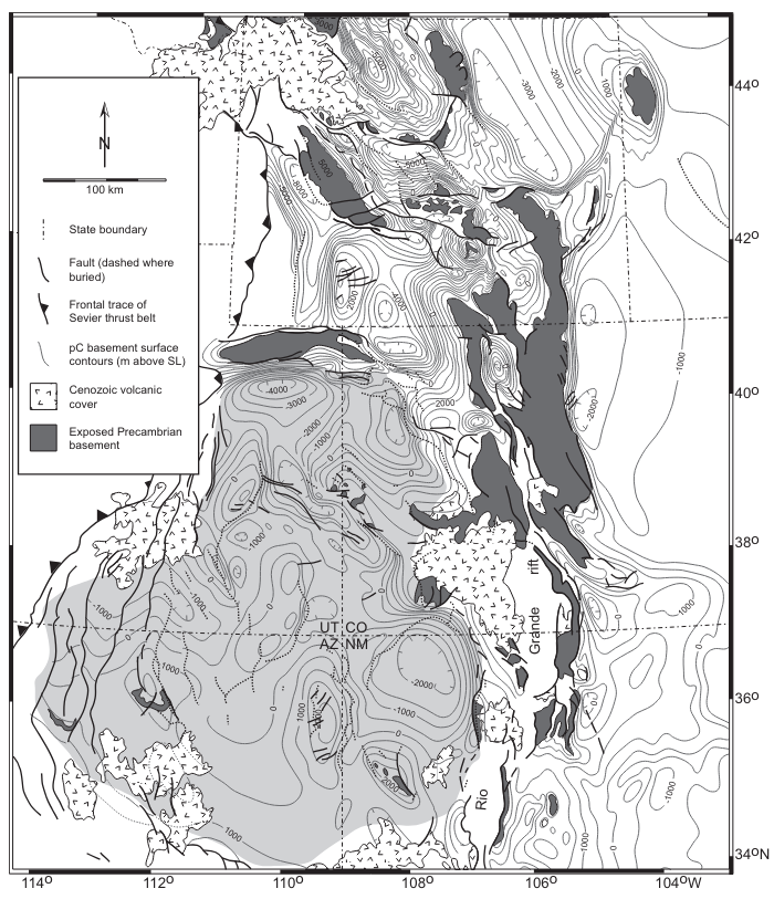
The Muddy Creek layers in the Mesquite Basin say nothing of the age of the Colorado, but instead they infer the date when the upper virgin basin was separated from the Colorado by the traverse fold highlighted in red in the figure above.
.
THE SALTON TROUGH AS AN ANALOG
A great modern analog of Lake Hualapai and Muddy Creek Lakes depression is the Salton Trough. It also has thick limestone deposits that border on Tufa. I’ll bet it has a similar geochemistry. Deposits on the alluvial fans downstream of Borrego Springs are locally derived and the natural levees of the Colorado River keep it separate from the Trough most the time with small exceptions.
Image of Lake Cahuilla Shoreline, just above Coolidge Springs north-west of the Modern Salton Sea. Ancient shoreline of the short-lived Lake are readily visible. (Image from google earth from user Robert Hyatt. Likely open source-ish)
IMAGINE USING SIMILAR GEOLOGIC UNITS IN THE SALTON TROUGH TO SUGGEST THE COLORADO DIDN’T EXIT TO THE SEA DURING THE LAST ICE AGE?!
CATHEDRAL VALLEY AS AN ANALOG TO HUALAPAI FM
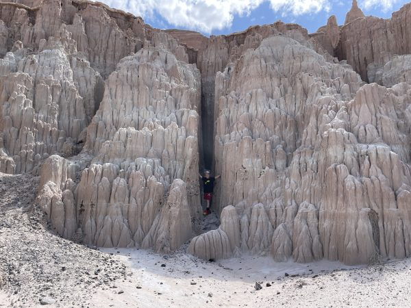
(Image of lacustrine sediments of Cathedral Valley Nevada. replace with my pics)
The thick basel limestone units are a good example of how a trapped lake can form right next to an existing river course.
.
Be sure to answer the Pearce 2010 paper that suggests that the Grand Wash Trough’s Hualapai Limestone (Miocene) and its layers beneath did NOT have Colorado River signatures. My argument is that the Colorado flowed through without leaving much evidence until 5mya when it was BLOCKED from its west exit and was redirected south. The layers in that trough were MUCH like the flood deposits of Grand Junction to the north, most the sediment in those layers come from the adjoining Cretaceous hills, but the river does back up occasionally during huge outflow floods from the Rockies. IN FACT she mentions that the water chemistry is like spring fed Havasu creek (high in carbonate), I suggest this is evidence of an ice dam break, which caused a short lived backup and limestone formation.
(Pearce 2010) https://digitalrepository.unm.edu/cgi/viewcontent.cgi?article=1047&context=eps_etds
GRAND MESA & EAGLE RIVER VOLCANICs
The Grand Mesa basalts date to around 10mya and sit about 5,000 feet east above Grand Junction and give some indication of the timing and amount of erosion of the upper Colorado River. They are often used to suggest the 5 Ma age of Colorado River creation. But these can’t be considered without also considering the Miocene Eagle River Collapse Center basalts just upstream (Hinsdale Formation & Servilleta Formations?). These basalts sit on the Weber Sandstone on a surface that feels like eastern Split Mountain. And they date to EARLIER than those of Grand Mesa (as early as 30-20 Ma), and yet they are on a more eroded surface suggesting….
This GSA paper by Lidke et al 2002 details the entire Miocene/Oligocene history of the upper colorado, and there was definitely considerable erosion on the surfaces these 30-20 Ma basalts are deposited on!
https://coloradogeologicalsurvey.org/wp-content/uploads/RT-0061890-i0-8137-2366-3-366-0-101.pdf
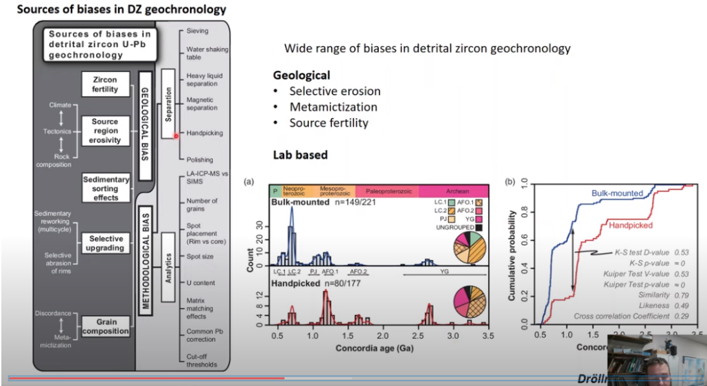
DETRIDAL ZIRCONS
The detridal Zircon evidence see page 83, Pearce 2010, ONLY speaks to where most the sediment in those beds was coming from.
Fall of the Nevadaplano (15-0 MYA)
-The beginning of Basin & Range extension is well researched from abundant evidence. (write a summary of it here)
I think the only common misunderstanding I see and read about regarding it, is the fact that nearly EVERY extensional fault and mountain range in the region is a reactivated Mesozoic & early cenozoic feature. And many of the normal faults likely began during compression. I think many geologists forget or dont learn that although compressional faults are rare under extensional forces, extensional (normal) faults are incredibly common during compressional forces.\
In other words, many normal faults that are often supposed to be associated with Basin & Range extension were actually formed during early compression. Likewise, many basin deposits which are believed to be associated with Basin & Range extension were actually deposited in subsiding basins during compression. [AND HONESTLY THIS IS HUGE… WE NEED MORE GEOLOGIST FINDING THESE DEPOSITS BECAUSE THEY WILL FILL IN HUGE GAPS OF OUR UNDERSTANDING.]
The Grand Castle and Canan Peak Formations are late Cretaceious in age, perhaps as early as 100mya suggesting orogenic uplift made its way to central utah around this time

Colorado River Formation References (Papers to Cite)
-Great overview of Green River capture: Revisiting the Classic Conundrum of the Green River’s Integration through the Uinta Uplift. Joel Pederson (use its refs, its in my peleo drive folder)
-Pre-Colorado River Paleogeography and ext along the… James Faulds, Price & Wallace (my folder)
-search through all of these: file:///H:/My%20Drive/%60UtahGeology.com%20Website%20Stuff/paleogeography%20reconstructions/paleogeography%20papers/Tons_Of_Colorado_Platuea_Evolution_Papers.htm
-DRAW SOME ILLUSTRATIONS WITH ALL THESE EVIDENCES ON THE MAP!!
-ALSO DRAW A MAP OF CLARON FM area of the Grand Staircase showing that as soon as the four basins (pinevalley, markugunt, paunsagunt & Aquarius Plateaus) finish filling, they are uplifted and SEPARATED at 33 mya which causes EACH to find an outlet to the south through the paleo-virgin, Kanab creek, Paria and Escalante drainages.
-REMEMBER: knowing from the Bishop Cng and Wasatch Plateau that the folds really took off AFTER 33 mya, is important, because then we can also assume that the Paria/Cockscomb, Kaibab uplift and Virgin River Gorge uplift really take off then too. AND WE KNOW EACH OF THEM MUST HAVE REVERSED BY 33 MYA!
-And the reversal of the Paria drainage has major implication to the formation of the Grand Canyon, It must have been flowing the current direction by not much after 33 mya, and had to have been flowing INTO the claron basins,
-WHEN DOES THE VIRGIN RIVER REVERSE? During the Claron of course! Between 55-33 mya, and all the others are likely the same!
WHEN DO THE COLORADO PLATEAU UPLIFTS OCCUR?
-I think they must be later/more recent than I first thought. It makes sense that they match with the emplacement of the intrusions, AND they have to be late if the colorado river migrated from the early cenozoic lakes, because it had to move across the san rafael swell, circle cliffs AND kaibab, so they must post date 33-25ish mya. Check out this article and quote which backs this up:
“the rise of the Kaibab and Circle Cliffs uplifts. Stockli et al. (2002) hoped to apply the (then) new technique of (U-Th)/He thermochronology to the problem of dating structural deformation of many of the Colorado Plateau uplifts. To that end, they collected and analyzed samples from stratigraphic profiles on the Circle Cliffs, San Rafael, Monument, and Kaibab uplifts. Unfortunately, all of the samples yielded ages from 33 to 11 Ma, consistent with uplift and denudation of the Colorado Plateau, but too young to be referencing the rise of individual Laramide uplifts”
https://www.geo.arizona.edu/sites/www.geo.arizona.edu/files/Colorado%20Plateau%20Structure.pdf
Stop using detrital Zircons!!!
They may work great in a wide variety of cases such as the dating of the Bishop conglomerate and Browns park fms, or Peach Springs conglomerates, but they just don’t work for finding the Colorado because ITS LIKE A FINDING A NEEDLE IN A HAYSTACK trying to find the early signatures for the colorado river in all those extensional basins, and what are you going to match it with? There are no good matches of areas upstream (other than the bishop cng?)
Source: https://www.youtube.com/watch?v=CiyNnu5o0O4
Here’s another bullcrap paper on re-dating the Browns Park Fm with detridal zircon (write a rebuttal to this and the colorado river one..
https://par.nsf.gov/servlets/purl/10081863