Toroweap/Coconino/White Rim Sandstone (Geology of The Grand Canyon)
Explore unit thickness in All-in-One App

Exposure:
The Toroweap & White Rim Sandtones are best seen in Southern Utah and Northern Arizona.
Age: Early Permian, 280 million years ago.
Depositional Environment: Coastal dune field (eolian with some marine transgressions). Marine transgressions, terrestrial wind-blown sand, coastal environments laid down the Kaibab, Toroweap, and Coconino formations. At different time, the marine waters came from the west, and receded and re-transgressed. The Coconino Formation represents a regional subaerial sea of sand that existed during a major regression. The Toroweap Formation represents a major marine transgression into the Grand canyon area during which red beds of the Seligman Member accumulated in supratidal, tidal, and terrestrial coastal plain environments. The overlying limestones of the Brady Canyon Member accumulated in open and brackish-water environments during the maximum extent of the marine transgression. A brief regression buried the sediments of the Brady Canyon Member under additional supratidal, tidal, and terrestrial coastal plain red beds of the Woods Ranch Member. The two members of the overlying Kiabab Limestone represent two additional major marine transgression into the Grand Canyon region.
Paleogeography: Sediment deposition was affected by the Uncompahgre uplift , but by the end of the Permian the Uncompahgre mountains had been worn down and was not longer a major sediment source.
Tectonics: The collision of the Gondwana Plate with the North American Plate resulted in the Uncompahgre highland.
Climate: Warm current winds
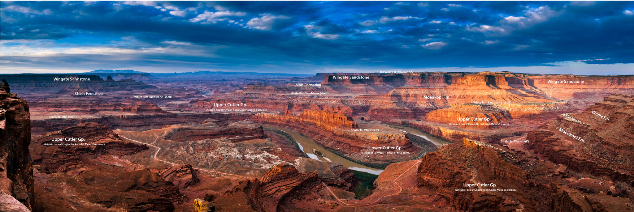
Features: The White Rim Sandstone is the upper member of the Permian Cutler Croup of rocks. The White Rim Sandstone gets its name from the white color that is due to bleaching from hydrocarbons (organic compounds). This formation often creates a white band found along canyon rims where it is often relatively thin. The White Rim Sandstone is a cliff-forming formation consisting of fine- to coarse-grained sandstone (Condon, 1997). This sandstone commonly displays large scale, high-angle cross-beds (dipping sediment layers) deposited by wind blown dunes. The thickness of this formation ranges from 5 to 75 feet thick (Morris, 2003). The depositional environment that this was deposited in was a coastal dune field that was intermittently flooded by marine water resulting is some reworking of sediments (Komola and Chan, 1988). The White Rim Sandstone can be viewed from the Goosenecks Overlook at the bottom of Sulphur Creek Canyon in Capitol Reef National Park.


Description:
The White Rim Sandstone is a sandstone geologic formation located in southeastern Utah. It is the last member of the Permian Cutler Group, and overlies the major Organ Rock Formation and Cedar Mesa Sandstone; and again overlies thinner units of the Elephant Canyon and Halgaito Formations.
The White Rim is eponymous, as the sandstone is named for its prominent white color, and forms the rims of cliffs.
It is the continental geologic formation deposited at the time of marine transgressions during the Early to Middle Permian Period.
The coeval Toroweap Formation was laid down under marine conditions along the southwest margin of the North American continent and is found in northwest Arizona layered between Coconino Sandstone and the Kaibab Formation. The Toroweap is mostly from the Grand Canyon and just eastwards to Lee’s Ferry-(Colorado River, Grand Canyon), south to the Verde Valley region (Sedona, Sycamore Canyon, Oak Creek Canyon), but the Toroweap also occurs within sections in southeast Utah, and also became overlain by the Kaibab Formation, specifically at the Circle Cliffs, west of the Waterpocket Fold.
Toroweap Description:
The Toroweap Formation exhibits well-defined lateral and vertical changes in facies over its outcrop. In the western extent of its outcrop in the Grand Canyon region and adjacent parts of Utah and Nevada, the Toroweap Formation is readily subdivided, in ascending order, into the Seligman, Brady Canyon, and Woods Ranch members. Two of these members (Seligman and Woods Ranch members ) consist of red beds and evaporites (gypsum) and are separated by a fossiliferous limestone member (Brady Canyon Member). The red beds of the Seligman and Woods Ranch members are largely of soft, friable sediments, which rapidly weather into slopes, The Brady Canyon Member is a resistant limestone which characteristically stands up as a prominent cliff between the slopes of the Seligman and Woods Ranch members. Further eastward, the Brady Canyon Member disappears, and the two red bed members merged together into an undivided Toroweap Formation. Further east, the red beds grade laterally into cross-bedded sandstones of the Sand Cave Member of the Coconino Sandstone.[4][9][10]
The Seligman Member of the Toroweap formation largely consists of fine-grained, red and yellow sandstone. It typically exhibits flat or irregular bedding. Its maximum observed thickness is about 50 ft (15 m) and in most places is no thicker than 45 ft (14 m). At its upper contact, the Seligman Member grades upwards through a transitional zone of alternating beds of sandstone and limestone into the fossiliferous limestone of the Brady Canyon Member. In Grand Wash Canyon on Lake Mead, the sandstones of the Seligman Member contain a very conspicuous layer of breccia, interpreted to be an intraformational conglomerate, only a few feet above the top of the Coconino Sandstone. The basal layer of the Seligman Member is a red sandstone or siltstone composed of Coconino-like quartz grains scattered through finer-grained sediment. The Seligman Member interfingers with and lies conformably on the underlying Coconino Sandstone.[3][4][10]
Overlying the Seligman Member is the Brady Canyon Member. It consists of cliff-forming limestone and dolomite. Laterally, the Brady Canyon Member is divisible into two facies grading from one through a third transitional facies into the other using differences in lithology and fossil content. The first facies is exposed in an area from the extreme western edge of its outcrop belt east to Toroweap Valley and southeast almost to Seligman, Arizona. This facies consists of a marine limestone that is mostly coarsely crystalline and cherty in some beds. This facies contains a fauna dominated by brachiopods and echinoids. The second facies of the Brady Canyon Member is exposed in outcrops eastward past Seligman, Arizona to where it merges and terminates within the enclosing red beds. In consist of fine-grained, mostly sand-, silt-, and clay-free limestone. It contains a fauna composed almost exclusively of abundant, but poorly preserved, pelecypods and gastropods. It apparently accumulated nearer the coastline and likely under brackish-water conditions. The transition zone between the two facies consists of an unfossiliferous, thin-bedded (1 to 2 in (2.5 to 5.1 cm) thick), uniform-textured dolomite. This limestone weathers into smooth, small, angular cobbles. In western Grand Canyon region, it is thickest, as much as to 280 ft (85 m) thick. The Brady Canyon Member thins uniformly to the east where it is of approximately 220 ft (67 m) thick in the type section in Toroweap Valley and disappears near Marble Canyon as it merges with the overlying Woods Ranch Member. Beds of the third (dolomite) facies recur between overlying red beds of the Woods Ranch Member and the other facies of the Brady Canyon Member as part of a gradational contact between these members. Below Desert View Point in Grand Canyon, the Brady Canyon Member is about 20 ft (6.1 m) thick and is entirely missing in outcrops along the Little Colorado Canyon and in Sycamore Canyon.[3][4][10]
The red beds of the Woods Ranch Member consist of interbedded layers of gypsum, thin-bedded dolomite, and sandstone. Eastward of Havasu Canyon this member lack gypsum and dolomite and contains beds of white, cross-bedded sandstone. Breccias or intraformational conglomerates occur in many places throughout the entire outcrop of the Woods Ranch Member. Associated with these breccias in some places are lacustrine travertines. A prominent feature found throughout the entire outcrop of the Woods Ranch Member is a fossil-bearing limestone, It occurs over a remarkably wide area without appreciable variation with a thickness of only 3 to 4 ft (0.91 to 1.22 m). The fossils found everywhere in with this marker bed consist only of a pelecypod of the genus Schizodus. This member forms distinctive slopes and attains a maximum thickness of about 180 ft (55 m).
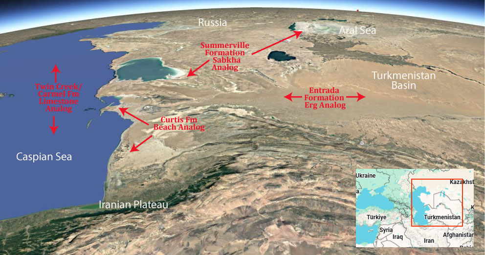
Modern Analog to Utah’s Middle Jurassic
.
Paleogeography or Depiction of Utah during Middle Jurassic

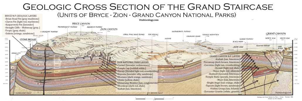
What is the Grand Staircase?
The Grand Staircase is a unique and extensive exposure of Earth’s history, showcasing over 200 million years of sedimentary rock layers. Geologists often liken these layers to a “book,” allowing for a detailed study of the Earth’s past, including changes in climate and environment.
The major sedimentary rock units exposed in the Grand Canyon range in age from 200 million to 600 million years and were deposited in warm shallow seas and near-shore environments. The nearly 40 identified rock layers of Grand Canyon form one of the most studied geologic columns in the world.

Trackways in the Coconino Sandstone, Grand Canyon.


[flickr_tags user_id=”95435349@N04″ randomize=”true” margins=”4″ pagination=”numbers” tags=”navajo” max_num_photos=”9″]
[flickr_tags user_id=”95435349@N04″ tags=”chinle, navajo”]