Grand Canyon’s Tapeats Sandstone (Geology of The Grand Staircase)
Explore unit thickness in All-in-One App

Exposure: The Tapeats is most spectacularly exposed in the Grand Canyon, Arizona, where it forms the dark, prominent cliff directly above the Inner Gorge. Excellent accessible views are found at the base of the Bright Angel Trail and along the Tonto Trail, where the unit creates a distinct “stair-step” in the canyon’s profile.
Age: Early to Middle Cambrian (approx. 508–525 Ma)
Lateral Equivalents: Flathead Sandstone (WY/MT), Sawatch Quartzite (CO), Geertsen Canyon Quartzite (UT/ID), Tintic Quartzite (Central UT), Prospect Mountain Quartzite (NV)
Depositional Environment: The environment was a high-energy, tide-dominated nearshore and shoreface setting. It includes beach sands, intertidal flats, and shallow subtidal channels. The presence of large-scale cross-bedding and rounded quartz pebbles indicates powerful water currents and constant wave action that winnowed out finer silts, leaving behind mature, resistant sand.
Paleogeography:During deposition, the Southwest was located on the western passive margin of Laurentia at equatorial latitudes. The area was a vast, low-relief coastal plain transitioning into a broad epicontinental shelf. The lack of terrestrial vegetation meant the coastline was a stark landscape of sand dunes and rocky outcrops.
Tectonics: This period followed the successful rifting of Rodinia, occurring during a tectonically quiet phase. The region experienced thermal subsidence as the crust cooled, allowing the sea to transgress across the “Great Unconformity.” There was very little active deformation, resulting in the widespread, flat-lying nature of these basal sands.
Climate: The climate was tropical to subtropical, as North America straddled the equator. With high atmospheric CO2 levels, the Earth was in a greenhouse state. Intense chemical weathering on the barren continents provided the massive volume of quartz sand, while warm, shallow coastal waters facilitated high energy and sediment transport.
Features: The unit is notable for its resistant, cliff-forming nature and deep brown to reddish-tan coloration. It features spectacular primary sedimentary structures, including meter-scale tabular and trough cross-bedding, ripple marks, and “lag” deposits of well-rounded quartz pebbles at the contact with the underlying Precambrian Schist and Granite.
Fossils: The Tapeats is famous for its ichnofossils (trace fossils), particularly Skolithos—vertical, pipe-like burrows created by suspension-feeding organisms in the surf zone. While body fossils like trilobites are rare due to the high-energy environment, they are occasionally found in the upper, finer-grained transition zones leading into the Bright Angel Shale.


Description:
The Tapeats Sandstone represents the dramatic onset of the Paleozoic Era across the American Southwest, serving as the basal member of the Tonto Group. Formed approximately 508 to 525 million years ago during the Early to Middle Cambrian, the Tapeats is the stratigraphic record of a massive marine transgression—the Sauk Transgression—where rising sea levels pushed the shoreline eastward across the barren crystalline basement of the North American craton. In the Grand Canyon, this unit is famous for draping over the “Great Unconformity,” a staggering erosional gap representing over a billion years of missing geologic time. The formation is primarily composed of cliff-forming, cross-bedded quartz sandstones and conglomerates, reflecting a high-energy depositional environment characterized by migrating sand waves and shoreface currents. Modern analogs can be found in the high-energy, tide-dominated sandy shorelines of the North Sea or the Bay of Fundy, where powerful currents redistribute coarse sediments across a broad, shallow shelf.
The deposition of the Tapeats occurred along the western passive margin of Laurentia, the ancient core of North America. Following the Neoproterozoic rifting of the supercontinent Rodinia, the continental edge subsided, allowing the ocean to spill onto a remarkably flat landscape known as a “peneplain.” Because there were no land plants to stabilize the soil, the terrestrial surface was a stark, rocky wasteland. Weathering produced vast quantities of quartz-rich sand that were transported by wind and ephemeral braided streams toward the encroaching coast. As the sea advanced, these sands were reworked into a complex mosaic of beach, shoreface, and tidal-channel deposits. This process was diachronous, meaning the Tapeats “climbed” in time; it is older in the west (Basin and Range) and becomes progressively younger as it moves toward the continental interior of Arizona and Utah, recording the slow, relentless landward march of the Cambrian tides.
Regionally, the Tapeats Sandstone is part of a vast “blanket sand” that covers much of the Western United States, though it bears different names in adjacent basins. In northern Utah and southeastern Idaho, this basal Cambrian quartzite is known as the Geertsen Canyon Quartzite or the Brigham Group, which similarly rests atop Precambrian basement rock. In Wyoming and Montana, the time-equivalent unit is the Flathead Sandstone, a prolific ridge-former in the Wind River and Bighorn mountains. To the east in Colorado, the Sawatch Quartzite represents the same transgressive event as the sea reached the Ancestral Rocky Mountain region. Collectively, these units represent the first pulse of the Sauk Megasequence, a global sea-level rise that fundamentally restructured the paleogeography of the Cordilleran margin and set the stage for the subsequent “Cambrian Explosion” of marine life.
Modern Analog to Utah’s Middle Jurassic
.
Paleogeography or Depiction of Utah during Middle Jurassic

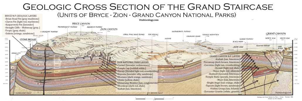
What is the Grand Staircase?
The Grand Staircase is a unique and extensive exposure of Earth’s history, showcasing over 200 million years of sedimentary rock layers. Geologists often liken these layers to a “book,” allowing for a detailed study of the Earth’s past, including changes in climate and environment.
The major sedimentary rock units exposed in the Grand Canyon range in age from 200 million to 600 million years and were deposited in warm shallow seas and near-shore environments. The nearly 40 identified rock layers of Grand Canyon form one of the most studied geologic columns in the world.

[flickr_tags user_id=”95435349@N04″ randomize=”true” margins=”4″ pagination=”numbers” tags=”navajo” max_num_photos=”9″]
[flickr_tags user_id=”95435349@N04″ tags=”chinle, navajo”]