Utahgeology.com Overview
The purpose of this site is to make Utah’s (and the Colorado Plateau’s) geology accessible to all and easy to learn. Utah already ranks third in the nation for national parks and monuments (behind only Alaska & California). This is a direct result of the states very unique geology. Zion, Bryce, Arches, Capitol Reef, Canyonlands, The Grand Staircase, Glen Canyon, and the Grand Canyon attract millions of visitors every year because these areas display the earth’s strata in a unique and spectacular way rivaled by few places on earth. This site tries to compliment these incredible geologic exposures of the Colorado Plateau by supplying a database of pictures and information which will aid those seeking to understand its unique geology.

Lance Weaver Bio
Welcome to Utah Geology! I began building this site nearly 20 years ago as a labor of love for sharing my passion for Utah’s geology. I have degrees & graduate training in Geology & Geophysics, and have worked in Public Outreach for the Utah Geology Survey for around 15 years as a Geologist pioneering their Data Management Program which helps to disseminate the research of our 60+ scientists to the public through interactive and engaging means.
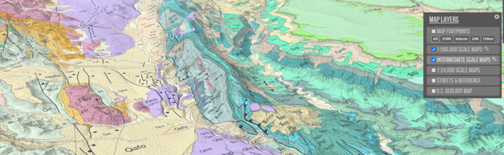
I am a pioneer in the geologic visualization space, creating perhaps the first state interactive geologic map visualizations way back with the very first release of Google Maps. At the UGS I’ve gained national notoriety for envisioning, designing and coding our 3D Map Portal, mapping application, which has consistently been among the top Interactive Geologic Mapping applications in the Nation. Working in information outreach and data management I’ve found unique ways to make our agencies scientific research more readily available to the public (primarily through articles, online storytelling and 3d visualizations and mapping applications). I’ve published more than a dozen circular articles on the geology of Utah, and am continually publishing additional geologic material, visualizations and ideas on my website.
My Story
I grew up in St George, Utah (located in the southwestern corner of the state). As a high school student I became captivated by maps. Hiking was my favorite pastime and I began to acquire topo maps in order to fulfill my goal to hike every canyon in nearby Zion National Park. As I started buying topo maps for Zion, I slowly expanded my area of interest. I bought every 7.5 Minute series topo map for Washington County and taped them together floor to ceiling on my bedroom walls. I was fascinated by the way maps allowed me to come to know a place without even being there–and better understand it once I was there. I would sit and memorize them for hours and try to guess what a canyon would look like before I hiked it, attempting to accomplish a goal of exploring every possible canyon in the region.
Later I began to acquire aerial photos, satellite imagery and geological maps as well which entirely captivated me. The more I learn about an areas geology and physiography – the more I want to know about what makes it the way it is. I believe that the more perspectives we can view an area with, the more we appreciate what’s there. I am also very interested in cosmology, history, religion and in debates such as evolution and the age of the earth. I think there is a lot more to this blue marble on which we live than meets the eye, but in the end… I don’t really care about all that stuff as much as I care about enjoying and having fun with my family.
This site is basically a compilation of all the resources I wish I had when I was first trying to learn Utah’s geology. And since I still have a lifetime of learning to do, the site will continue to grow, as I pass along the things that help me to view the earth from as many angles as possible.
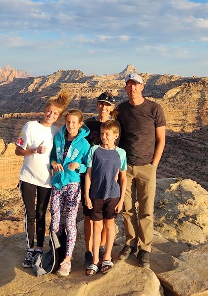
In my personal research I also specialize in general prehistoric paradigms, stratigraphic paleo-reconstructions and making complex scientific research digestible to the public through computer mapping visualizations. As well as geoarchaeology or the interaction of archaeology with earth systems (especially in regard to earth’s magnetic field, radiometric dating and ice ages). By hobby, I consume history, physics, channeled literature and spiritualism. In practice, I am mostly a father, tour guide and nature explorer.
.
.
PUBLICATIONS
Weaver Lance, The Henry Mountains, Utah Geological Survey. Survey Notes, v. 53 Number 3, September 2021. pdf, web, ugc
Weaver, Lance. What Gives Utah’s “Redrock Country” Its Color? Utah Geological Survey. Survey Notes, Volume 52, No. 3, September 2020. pdf, web, ugc
Weaver, Lance. The Cockscomb And Kaibab Uplift Of Southern Utah. Utah Geological Survey. Survey Notes, v. 49 no. 1, January 2017. pdf, web, ugc
Lance Weaver, Dao Yank & Derek Anderson. A Water Resource Feasibility Study for the Kanab Water District, Feb 2022.
Robert Blackett, Mark Gwynn, Rick Allis, Christian Hardwick, Lance Weaver, and Kevin Thomas. Utah Contributions to the National Geothermal Data System. Utah Geological Survey, GRC Transactions, Geothermal Resources Council. Vol. 37, p559-563. 2013.
Weaver, Lance. Pine Park and the Ancient Supervolcanoes of Southwestern Utah, Utah Geological Survey. Survey Notes, Volume 51, Number 2 • May 2019. pdf, web, ugc
Weaver, Lance. Why are there so Many Natural Arches in Utah, Utah Geological Survey. Survey Notes, v. 46 no. 3, September 2014. pdf, web, ugc
Weaver, Lance. Keeper Potholes & How Are They Formed, Utah Geological Survey. Survey Notes, v. 46 no. 3, September 2014. pdf, web, ugc
Lance Weaver, Dao Yank & Derek Anderson. Geothermal potential of Caliente Springs Area. Geotechnical Investigation for Central Nevada Water Authority, 2010.
Lance Weaver, Marshall Robinson, Jay Hill. UGS Geologic Map Portal. Utah Interactive Compilation of UGS mapping. UGS Web Applications, 2016. web, pdf
Lance Weaver, Jay Hill, Utah Hazards Portal. GIS compilation of all major hazards mapping data for the Wasatch Front and Washington County. UGS Web Applications, 2019.
Lance Weaver, Steve Bowman. The Utah Geochronology Database. Online portal to all available UGS geochronology data. UGS Web Applications, 2018.
Weaver Lance. Earthquakes of the Last 12 Months: An Interactive 3D Visualization. UGS Web Applications, 2020. web
Weaver, Lance. Cascade Falls, Kane County, Utah. Utah Geological Survey. Survey Notes, v. 42 no. 1, January 2010. pdf, web, ugc
Weaver, Lance. Crystal Geyser, Grand County, Utah. Utah Geological Survey. Survey Notes Volume 50 Number 1, January 2018. pdf, web, ugc
Weaver, Lance. 2018 Zion National Park Rockfall River Walk Trail Hazard Photo Assessment. Utah Geological Survey. Hazard Data Collections, June 04 2018
Biek, Robert, Brown, Kent & Weaver, Lance. Virtual Geologic Map Overlays: A New Way to Visualize Geologic Map Information. Utah Geological Survey, Survey Notes, Volume 41 Number 2, May 2009. pdf, web
Kent D. Brown, Lance B. Weaver, and Robert F. Biek. Creating a Virtual Geologic Map and Field Trip of the St. George 30’x60’ Quadrangle, Washington County, Utah: An Adventure in Google Earth. Digital Mapping Techniques ‘08—Workshop Proceedings, U.S. Geological Survey Open-File Report 2009–1298 https://pubs.usgs.gov/of/2009/1298/ web
Utahgeology.com. Author, Content Creator and Manager. Consistently ranked as one of the premier online resources for stratigraphic information on Utah’s Geology.
Miller, Rick. Our Geological Wonderland: Blue Clay. SUU Independent. 2018. contributing material. web
Laura Zuckerman. Two dead in Utah as boulders crush home near U.S. national park. Chicago Tribune, Dec 12, 2013. contributing material. web
Williams, Carter. This is arch: Utah geologists begin ‘Arch Madness’ to highlight state’s many arches. KSL editorial. 2021. contributing material. web
–
RESEARCH INTERESTS
Paleogeography/Geologic History. Research and application development to create paleogeography reconstructions similar to those of Ron Blakey at ASU, except on an interactive web interface and tied to a stratigraphic database backend.
Geologic Hazards. Particular landslides and rock falls. Consulting geologist for Zion National Park 2016-2020 on rock fall and landslide hazards.
General geologic education. Currently writing a geologic road guide to Utah book, as well as geologic trail guides
–
AWARDS & RECOGNITION
Brians and braun behind (creator, coder and manager) of Utah’s most utilized geologic resource. The Utah Geological Survey Geologic Map Portal. Seemless portal to all of Utah’s geologic maps.
2010 UGA Crawford Award. Bob Biek, Grant Willis, Janice Hayden, Lance Weaver. St. George 30×60 quadrangle Geologic Map. Online edition.
2011 Outstanding Service Award for contribution to furthering geologic knowledge in the State of Utah
–
IN THE MEDIA
Featured on live Channel 4 ‘Good4Utah’ 6/4/2014. “Underneath Utah”, speaking on the volcanism on Cedar Mountain, near Panguitch Lake
Featured on live Channel 4 ‘Good4Utah’ 5/2014. Speaking on the formation of Cedar Breaks National Monument
–
WORK EXPERIENCE
UTAH STATE GEOLOGICAL SURVEY, SALT LAKE CITY, UTAH.
• Position(s): Geologist, Data, mapping resources & development. Researcher & Author
UTAH GEOLOGY SCENIC TOURS. Owner. Sole Operator.
WEAVER ENGINEERING, ST. GEORGE, UTAH.
• Position(s): Manager / Engineering Assistant.
ROSENBERG AND ASSOCIATES CONSULTING ENGINEERS AND LAND SURVEYORS, ST. GEORGE, UTAH. (2002)
• Position(s): Geotechnical Technician. Lab work and field testing.
–
EDUCATION
University of Utah Salt Lake City, Utah
• 2006 Geology & Geophysics.
Brigham Young University Provo, Utah
• 2004 Geology.
Dixie State University St. George, Utah.
• 2000. General Studies