Summerville Formation (Geology of Utah’s Grand Staircase)

Explore unit thickness in All-in-One App

Exposure:
Within the Grand Staircase, the Summerville Formation is best exposed in east of Capital Reef National Park just south of Goblin Valley State Park.
Age: Deposited Middle Jurassic, early to late Oxfordian time (161 – 155 Ma) (Wilcox, 2007).
Depositional Environment:
Marginal marine and sabkha/tidal. One unconformably-bound, transgressive-regressive (T-R) sequence, marine (saline lacustrine?) and marginal-marine (Wilcox, 2007).
Paleogeography:
A major transgression of the Late Jurassic seaway drowned the eolian sand sea of the Entrada Sandstone. Subsequent regressive paleoflow was to the northeast into the Late Jurassic interior seaway (Kocurek & Dott, 1983, Blakey 2008).
Tectonics:
Deposition was in a retroarc to craton-margin basin as the region drifted north (Kocurek & Dott, 1983).
Climate:
Hot & Arid. Kocurek & Dott, 1983 suggest paleolatitude range of 5 to 25 degrees north. I disagree and suggest 25-40 degrees north within a stark rain shadow of the ancient Navadaplano, similar to current Mapmi basin in Mexico.
Features:
The Summerville is noted for its thin red beds of rippled sandstones and mud cracks, overprinted with secondary gypsum veins. The Jurassic “J3” unconformity, a regional surface of erosion atop the Entrada Sandstone, marks the basal bounding surface of the Curtis-Summerville T-R sequence. A thin, lower Curtis transgressive systems tract is the finest grained facies of the Curtis Formation topped by a maximum flooding surface. Thick middle and upper Curtis represents a highstand systems tract reflected in upward coarsening cycles from marine shelf to tidal channels to shoreface. The upper sequence is tidal flat, reddish-brown mudstones and evaporites of the Summerville Fm topped by the “J5” unconformity, the upper sequence bounding surface and the contact with overlying Morrison Formation (Wilcox, 2007).

Description:
The Summerville formation consists of up to 100 meters (330 ft) of red mudstone, with thin interbeds of green and red sandstone. The lower portion of the formation shows polygonal desiccation cracks and localized salt-hopper casts while the upper portion contains considerable gypsum, consistent with deposition in a sabkha on the margin of the Sundance Sea.It is exposed in the San Rafael Reef, the Waterpocket Fold, in the Henry Mountains, with additional exposures scattered across the region from the San Rafael Reef to the Paradox Basin, and in north-central New Mexico. The thin bedding is characteristic throughout the formation, but gypsum is not found in the San Juan Basin and some conglomerate is found on the south and southwestern margins of the formation. The correlation of late Jurassic beds in northwestern New Mexico with the Summerville Formation in Utah has been questioned, and it has been suggested that they be assigned to the Beclabito Formation instead.
The Summerville Formation rests conformably on the underlying Curtis Formation (Utah and western Colorado) or Todilto Formation (southwest Colorado and New Mexico) but is separated from the overlying Morrison Formation by the regional J5 unconformity.[1] It thins significantly in the Moab-La Sal area, the likely area of the divide between the marine Curtis basin to the northwest and the salina lake Todilto basin to the southeast. Here the formation is just 1.2 meters (3.9 feet) thick and rests directly on Entrada Sandstone. In many locations the Summerville is separated from the Morrison by eolian sandstones, such as the Bluff Sandstone, variously assigned to the Morrison Formation or the San Rafael Group. The Morrison Formation represents a return to more humid conditions with increased clastic input.
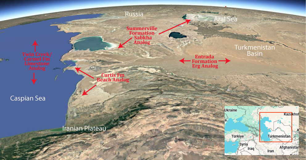
Modern Analog to Utah’s Middle Jurassic

.
Paleogeography or Depiction of Utah during Middle Jurassic

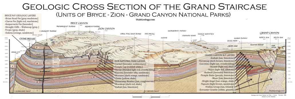
What is the Grand Staircase?
The Grand Staircase is a unique and extensive exposure of Earth’s history, showcasing over 200 million years of sedimentary rock layers. Geologists often liken these layers to a “book,” allowing for a detailed study of the Earth’s past, including changes in climate and environment.
The major sedimentary rock units exposed in the Grand Canyon range in age from 200 million to 600 million years and were deposited in warm shallow seas and near-shore environments. The nearly 40 identified rock layers of Grand Canyon form one of the most studied geologic columns in the world.


